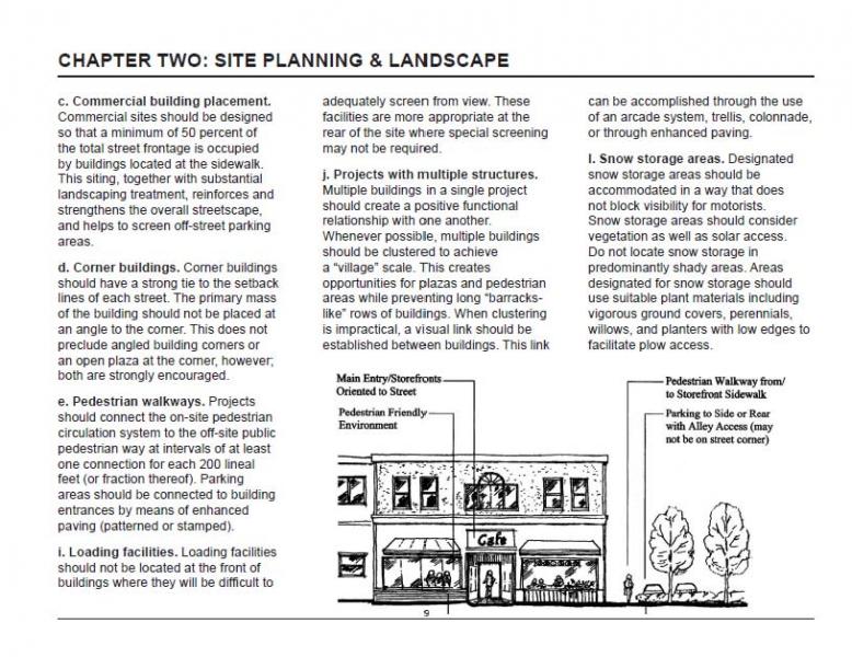
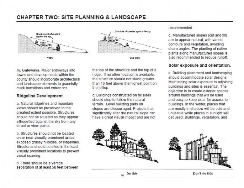
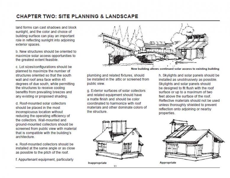
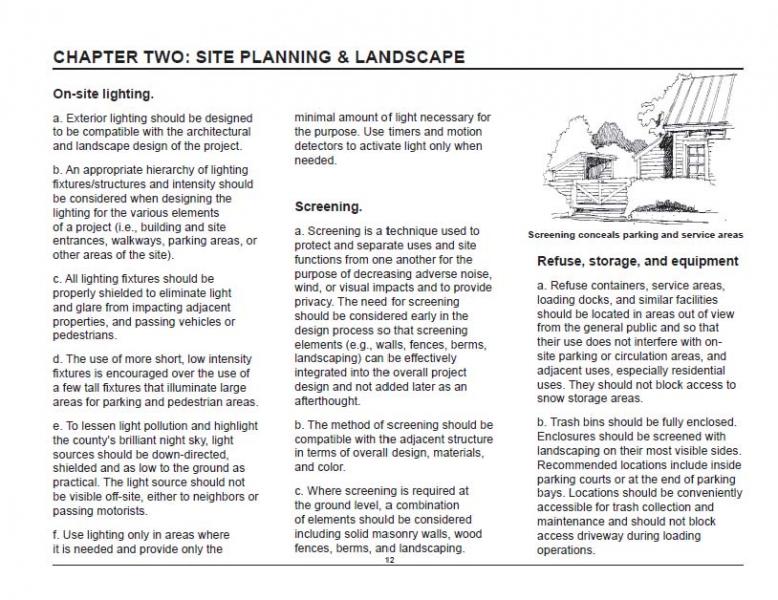
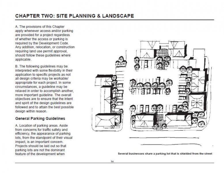
General Plan
Government Code § 65300 requires each county to "adopt a comprehensive long-term general plan for the physical development of the county." Mono County is unique in that the General Plan and Zoning Code have been combined into one document.
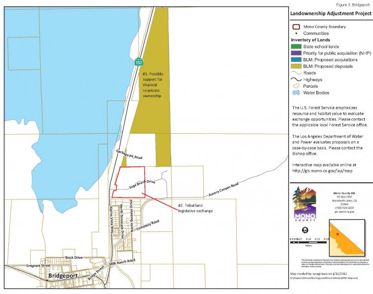
The purpose of the Mono County General Plan is to establish policies to guide decisions on future growth, development, and conservation of natural resources in the unincorporated area of the county. The plan reflects community-based planning and includes individual area plans for Mono County communities.
The following summarizes the vision of the Mono County General Plan:
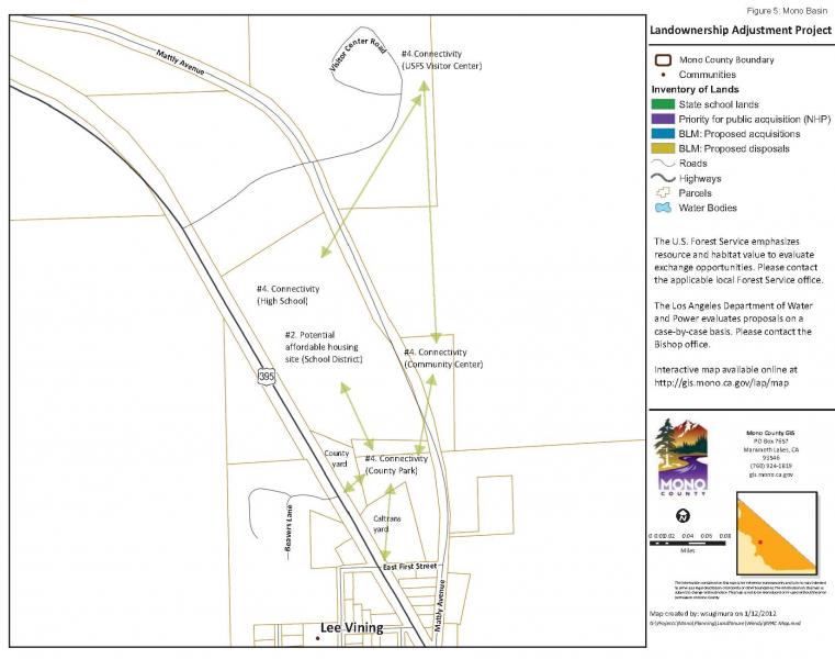
The environmental and economic integrity of Mono County shall be maintained and enhanced through orderly growth, minimizing land use conflicts, supporting local tourist and agricultural based economies, and protecting the scenic, recreational, cultural, and natural resources of the area. The small-town atmosphere, rural- residential character and associated quality of life will be sustained consistent with community plans. Mono County will collaborate with applicable federal, state and local entities in pursuing this vision through citizen-based planning and efficient, coordinated permit processing.
The planning areas of June Lake and Mono Basin also have separately published area or community plans, which are incorporated into the Land Use Element of the General Plan. These documents will be posted below when they are available.
The work upon which this publication is based was funded in part through a grant awarded by the California Strategic Growth Council. Disclaimer: The statements and conclusions of this report are those of Mono County and not necessarily those of the California Strategic Growth Council or of the California Department of Conservation, or its employees. The California Strategic Growth Council and the California Department of Conservation make no warranties, express or implied, and assume no liability for the information contained in the succeeding text.
02-06 Land Development Regulations
24.010 Definitions.
24.020 Findings.
24.030 Purpose and intent.
24.040 Nuisance.
24.050 Disclosure.
24.060 Notification.
24.070 Severability.
24.010 Definitions.
“Agricultural land” means land designated in the Land Use Element of the Mono County General Plan as “Agricultural,” regardless of the minimum acreage associated with the designation.
“Agricultural activity, operation, or facility or appurtenances thereof” (herein collectively referred to as “agricultural operations”) means and includes, but is not limited to the cultivation and tillage of the soil, dairying, the production cultivation, growing, and harvesting of any agricultural commodity including timber, viticulture, apiculture, or horticulture, aquaculture, the raising of livestock, fur-bearing animals, fish, or poultry, and any practices performed by a farmer or on a farm as incident to or in conjunction with those farming operations, including preparation for market, delivery to storage or to market, or delivery to carriers for transportation to market.
24.020 Findings.
The Board of Supervisors finds that it is in the public’s interest to preserve and protect agricultural land and agricultural operations within Mono County. The Board of Supervisors also finds that when nonagricultural land uses occur in or near agricultural areas, agricultural operations frequently become the subjects of nuisance complaints due to the lack of information about such operations. Such actions discourage investments in farm improvements to the detriment of agricultural uses and the viability of the county’s agricultural industry as a whole.
24.030 Purpose and intent.
The purposes of this chapter are to protect agricultural operations on land designated as Agricultural from conflicts with adjacent or nearby non-agricultural land uses, to support and encourage continued agricultural operations in the county, and to forewarn prospective purchasers of property located adjacent to or near agricultural operations of the inherent attributes of such purchase including, but not limited to, the sounds, odors, dust and chemicals that may accompany agricultural operations so that such purchasers and residents will understand the inconveniences that accompany living near agricultural operations and be prepared to accept those inconveniences as the natural result of living in or near agricultural lands.
This chapter is not to be construed as in any way modifying or abridging State law as set out in the California Civil Code, Health and Safety Code, Fish and Game Code, Food and Agricultural Code, Water Code, or any other applicable provision of State law relative to nuisance.
24.040 Nuisance.
No agricultural operation conducted or maintained for commercial purposes and in a manner consistent with proper and accepted standards within the agricultural industry as established and followed by similar agricultural operations in the same locality, shall be or become a nuisance, private or public, due to any changed condition in or about the locality, after the same has been in operation for more than three years if it was not a nuisance at the time it began.
24.050 Disclosure.
- Mono County recognizes the statewide policy to protect and encourage agriculture. Sections 3482.5 and 3482.6 of the California Civil Code and Section 24.040 of the Mono County General Plan protect certain preexisting agricultural production and processing operations (“agricultural operations”) from nuisance claims. If your property is near a protected agricultural operation, you may be subject to certain inconveniences and/or discomforts that are protected by law. In order for the agricultural operation to be protected, the following requirements of Civil Code Sections 3482.5 and 3482.6 must be satisfied:
- The agricultural operation must be conducted or maintained for commercial purposes;
- The agricultural operation must be conducted or maintained in a manner consistent with proper and accepted customs and standards as established and followed by similar agricultural operations in the same locality;
- The agricultural operation must predate the affected use(s) on your property;
- The agricultural operation must have been in existence for more than three years; and
- The agricultural operation must not have been a nuisance at the time it began.
- If your property is near an agricultural operation in the unincorporated area of the county, which satisfies the above requirements, you may at times be subject to inconvenience and/or discomfort arising from that operation. Such inconvenience may include (depending upon the type of agricultural operation protected), but is not necessarily limited to, the following: noise, odors, fumes, dust, legal pesticide use, fertilizers, smoke, insects, farm personnel and truck traffic, visual impacts, nighttime lighting, operation of machinery and the storage, warehousing and processing of agricultural products or other inconveniences or discomforts associated with the protected agricultural operations. For additional information pertaining to this disclosure and the county Right to Farm standards as set forth in the county General Plan, or concerns with an agricultural operation, please contact the Mono County Agricultural Commissioner’s office.
- This disclosure statement is given for informational purposes only and nothing in this chapter or in the disclosure statement shall prevent anyone from complaining to any appropriate agency or taking any other available remedy concerning any unlawful or improper agricultural practice.
- The disclosure statement set forth above shall be used as described in Section 24.060.
24.060 Notification.
Upon any transfer of real property located in the unincorporated area of the county by sale, exchange, installment land sale contract (as defined in Civil Code Section 2985), lease with an option to purchase, any other option to purchase, ground lease coupled with improvements, residential stock cooperative, improved with or consisting of not less than one nor more than four dwelling units, or resale transaction for a manufactured home (as defined in Health and Safety Code Section 18007) or a mobile home (as defined in Health and Safety Code Section 18008), which manufactured home or mobile home is classified as personal property and intended for use as a residence, the transferor shall deliver to the prospective transferee the written disclosure statement required by this chapter. The disclosure statement shall be delivered in the manner set forth in Civil Code Sections 1102.2 and 1102.10. Exceptions to the applicability of this section are set forth in Civil Code Section 1102.2. The written disclosure shall be set forth in, and shall be made on a copy of, the following disclosure form:
LOCAL OPTION
REAL ESTATE TRANSFER DISCLOSURE STATEMENT
THIS DISCLOSURE STATEMENT CONCERNS THE REAL PROPERTY SITUATED IN THE UNINCORPORATED AREA OF THE COUNTY OF MONO, STATE OF CALIFORNIA, DESCRIBED AS ___________________________. THIS STATEMENT IS A DISCLOSURE OF THE CONDITION OF THE ABOVE PROPERTY IN COMPLIANCE WITH CHAPTER 24 OF THE MONO COUNTY GENERAL PLAN AS OF _____________, 2006. IT IS NOT A WARRANTY OF ANY KIND BY THE SELLER(S) OR ANY AGENT(S) REPRESENTING ANY PRINCIPALS(S) IN THIS TRANSACTION, AND IS NOT A SUBSTITUTE FOR ANY INSPECTIONS OR WARRANTIES THE PRINCIPAL(S) MAY WISH TO OBTAIN.
I.
SELLER’S INFORMATION
The Seller discloses the following formation with the knowledge that even though this is not a warranty, prospective Buyers may rely on this information in deciding whether and on what terms to purchase the subject property. Seller hereby authorizes any agent(s) representing any principal(s) in this transaction to provide a copy of this statement to any person or entity in connection with any actual or anticipated sale of the property.
THE FOLLOWING ARE REPRESENTATIONS MADE BY THE SELLER(S) AS REQUIRED BY THE COUNTY OF MONO, AND ARE NOT THE REPRESENTATIONS OF THE AGENT(S) IF ANY. THIS INFORMATION IS A DISCLOSURE AND IS NOT INTENDED TO BE PART OF ANY CONTRACT BETWEEN THE BUYER AND SELLER.
“The County of Mono recognizes the statewide policy to protect and encourage agriculture. Sections 3482.5 and 3482.6 of the California Civil Code and Section 24.040 of the Mono County General Plan protect certain preexisting agricultural production and processing operations (“agricultural operations”) from nuisance claims. If your property is near a protected agricultural operation, you may be subject to certain inconveniences and/or discomforts that are protected by law. In order for the agricultural operation to be protected, the following requirements of Civil Code Sections 3482.5 and 3482.6 must be satisfied:
- The agricultural operation must be conducted or maintained for commercial purposes;
- The agricultural operation must be conducted or maintained in a manner consistent with proper and accepted customs and standards as established and followed by similar agricultural operations in the same locality;
- The agricultural operation must predate the affected use(s) on your property;
- The agricultural operation must have been in existence for more than three years; and
- The agricultural operation must not have been a nuisance at the time it began.
If your property is near an agricultural operation in the unincorporated area of the county, which satisfies the above requirements, you may at times be subject to inconvenience and/or discomfort arising from that operation. Such inconvenience may include (depending upon the type of agricultural operation protected), but is not necessarily limited to, the following: noise, odors, fumes, dust, legal pesticide use, fertilizers, smoke, insects, farm personnel and truck traffic, visual impacts, nighttime lighting, operation of machinery and the storage, warehousing and processing of agricultural products or other inconveniences or discomforts associated with the protected agricultural operations. For additional information pertaining to this disclosure and the county Right to Farm standards as set forth in the county General Plan, or concerns with an agricultural operation, please contact the Mono County Agricultural Commissioner’s office.”
Seller _________________________ Date
Seller _________________________ Date
II.
BUYER(S) AND SELLER(S) MAY WISH TO OBTAIN PROFESSIONAL ADVICE AND/OR INSPECTIONS OF THE PROPERTY AND TO PROVIDE FOR APPROPRIATE PROVISIONS IN A CONTRACT BETWEEN BUYER AND SELLER(S) WITH RESPECT TO ANY ADVICE/INSPECTIONS/DEFECTS.
I/WE ACKNOWLEDGE RECEIPT OF A COPY OF THIS STATEMENT.
Seller __________________ Date _____________ Buyer ____________________
Date ______
Seller __________________ Date _____________ Buyer ____________________
Date ______
Agent (Broker Representing Seller) ______________________
(by)______________________ (Associate Licensee or Broker signature)
Date ______
Agent (Broker Obtaining the Offer) _______________________
(by) ____________________ (Associate Licensee or Broker signature)
Date ______
A REAL ESTATE BROKER IS QUALIFIED TO ADVISE ON REAL ESTATE IF YOU DESIRE LEGAL ADVICE, CONSULT YOUR ATTORNEY.
24.070 Severability.
If any section or provision of this chapter or the application thereof to any person or circumstance is held invalid or unconstitutional by a court of competent jurisdiction, such invalidity or unconstitutionality shall not affect any other section or application of this chapter that can be given effect without the invalid or unconstitutional provision or application.
25.010 Intent.
25.020 Establishment of district.
25.030 Uses permitted.
25.040 Uses permitted subject to Director Review.
25.050 Uses permitted subject to Use Permit.
25.060 District requirements
25.070 Additional requirements.
25.010 Intent.
The Transient Rental Overlay District (TROD) is intended to provide additional tourism-based economic opportunities and homeowner economic stability by allowing a transient rental district to be overlaid on properties within residential neighborhoods exhibiting support for allowing transient rentals. The land use designation followed by the letters TR (e.g., SFR-TR) would indicate a Transient Rental Overlay District (TROD).
25.020 Establishment of district.
The transient rental district may be overlaid on any residential neighborhood, parcel, or group of parcels meeting the requirements of 25.060, and having land use designation(s) of SFR, ER, RR, MFR-L or RMH. In addition to the requirements of this chapter, initiation and application of a TROD shall be processed in the same manner as any land use redesignation (see Ch. 48, Amendments).
25.030 Uses permitted.
The following uses shall be permitted in the TROD, plus such other uses as the Commission finds to be similar and not more obnoxious or detrimental to the public safety, health and welfare:
- All uses permitted in the underlying land use designation.
- Where the principal use of the subject parcel(s) is single-family or multifamily residential the residence or any accessory dwelling unit on the parcel(s), may be rented on a transient basis subject to the requirements of 25.070.
25.040 Uses permitted subject to Director Review.
All uses permitted subject to Director Review in the underlying land use designation with which the TROD is combined shall be permitted, subject to Director Review approval.
25.050 Uses permitted subject to Use Permit.
All uses permitted subject to use permit in the underlying land use designation with which the TROD is combined shall be permitted, subject to securing a use permit.
25.060 District requirements.
- Overlay district area and overlay district formation noticing process:
A TROD may be applied to one or more existing legal parcels, provided that at least one parcel within the district is developed with a single-family or multifamily residence.
Applicants are strongly encouraged to propose districts made up from three or more parcels and to communicate with all adjacent property owners before submitting an application.
Applications for transient overlay districts consisting of one or two parcels or at the discretion of the planning director if greater than two parcels will require an overlay district formation noticing process prior to public hearing. Notice shall be provided to all property owners adjacent to the proposed transient overlay district and include a 20-day period for noticed property owners to request inclusion in the district.
- Overlay District shape:
New TRODs consisting of more than one parcel and district additions shall be contiguous, compact and orderly in shape as determined by the Planning Commission. Factors used to determine compact and orderly district shape include but are not limited to:
- Street-frontage sharing;
- Adjoining yards; and
- Existing neighborhood separation characteristics such as
- Subdivision boundaries
- Major roads
- Natural features
- Large undeveloped parcels
- Commercial or civic land use
25.070 Additional requirements.
Any person or entity that leases, rents, or otherwise makes available for compensation, a single-family or multifamily residence located within a TROD designated by this chapter, for a period fewer than 30 days, must first obtain a vacation home rental permit and comply with all applicable requirements of that permit, as set forth in Chapter 26, Transient Rental Standards and Enforcement.
Parcels located within conditional development zones (avalanche) shall not be allowed transient rentals during the avalanche season, November 1 through April 15.
26.010 Purpose and Findings.
26.020 Vacation Home Rental Permit.
26.030 Application and Issuance of a Vacation Rental Permit.
26.040 Standards and Requirements.
26.050 Rental Agreement and Owner Responsibility.
26.060 Compliance with Transient Occupancy Tax Requirements.
26.070 Enforcement.
26.080 Existing and Otherwise Permitted Rentals.
26.090 Unauthorized Rentals Prohibited.
26.010 Purpose and Findings.
- The purpose of this chapter is to implement procedures, restrictions, and regulations, and to provide for the payment of transient occupancy tax and applicable fees for the transient rental of properties within Transient Rental Overlay Districts (TRODs) designated pursuant to Chapter 25 of the Mono County General Plan and to provide enhanced enforcement tools to address unauthorized transient rentals countywide.
- The Board of Supervisors finds that allowing transient rentals within areas of the county designated for residential use will provide a community benefit by expanding the number and types of lodging available to visitors to Mono County, increasing the use of property within the county, and providing revenue to property owners so that the units may be maintained and upgraded.
- The Board of Supervisors also finds that the operation of transient rentals within residential communities should be regulated in order to minimize fire hazard, noise, traffic, and parking conflicts and disturbance to the peace and quiet. The Board further finds that current enforcement tools have been ineffective to address the illegal operation of transient rentals countywide, primarily because the penalty amount is easily offset by the revenue such uses generate.
26.020 Vacation Home Rental Permit.
Any person who rents a residential structure that is not a condominium (hereinafter "rental unit" or "property") within an area of the county designated as a transient overlay district on a transient basis shall comply with the provisions of this chapter, the Mono County General Plan, and any applicable area plans or specific plans. Transient rental of a private residence within a transient overlay district without a valid vacation home rental permit is a violation of this chapter.
26.030 Application and Issuance of a Vacation Home Rental Permit.
- Applicant. An applicant for a vacation home rental permit shall be either the owner of title to the subject property or his or her expressly authorized representative. The authorization shall be in writing and notarized.
- Application. An application for a vacation home rental permit shall be on a form that may be obtained from the Department of Finance or the Community Development Department. The following requirements and approvals must be met and substantiated before a vacation home rental permit will be issued:
- The rental unit must be located within an area of the county designated as a transient overlay district;
- The rental unit must comply with the standards and requirements as set forth in section 26.040, and any other requirement provided by this chapter. An inspection to verify compliance with such requirements shall be the responsibility of the owner or designated property manager. The owner or property manager shall certify in writing, under penalty of perjury, the rental unit’s conformance to such standards. Such certification shall be submitted to the Mono County Community Development Department prior to permit issuance;
- The applicant must designate the management company or property manager for the rental unit who will be available on a 24-hour basis to address any problems that may be associated with the property or the transient users of the property. The management company or property manager must be duly licensed, and shall be in good standing with the County. Alternatively, the property owner may serve as the property manager;
- The property must be certified by the Community Development Department as complying with parking requirements and any applicable land use regulations set forth in the Mono County General Plan;
- A Mono County business license must be obtained and must remain active during all times that the property is used as a transient rental;
- Any required fees must be paid in full; and
- A Mono County Transient Occupancy Certificate must be obtained from the Department of Finance and will be issued at the time the vacation home rental permit is issued and all conditions of approval have been met.
26.040 Standards and Requirements.
The following standards and requirements must be met in order to obtain a vacation home rental permit and to maintain that permit in good standing:
- Health and Safety Standards. The purpose of these standards is to establish minimum requirements to safeguard the public safety, health, and general welfare from fire and other hazards, and to provide safety to firefighters and emergency responders during emergency operations. These standards include without limitation:
- The address of the rental unit must be clearly visible;
- Carbon monoxide and smoke detectors must be installed and maintained in good operating condition in each bedroom, sleeping area, or any room or space that could reasonably be used as a sleeping area, and at a point centrally located in the corridor or area giving access to each separate sleeping room;
- All stairs, decks, guards, and handrails shall be stable and structurally sound;
- The rental unit shall be equipped with a minimum of one 2A:10B:C type fire extinguisher with no more than 75 feet of travel distance to all portions of the structure; there shall be no fewer than one such extinguisher per floor. Fire extinguishers shall be mounted in visible locations with the tops of the fire extinguishers mounted between 3 and 5 feet above the floor and shall be accessible to occupants at all times. California State Fire Marshal annual certification tags must be provided and be current on all extinguishers;
- If there is a fireplace or solid-fuel barbecue, the rental unit shall be equipped with a minimum five-gallon metal container with a tight-fitting lid for ash removal. This container shall be clearly labeled and constructed to meet the purpose of containing ash. Instructions on the proper disposal of ash shall be stated in the rental agreement and clearly posted in the rental unit. The ash container shall not be placed on or near any furniture or other combustible material; ashes must be wet down thoroughly with water; the ash can must be stored outdoors with a minimum of 3 feet clearance from building, porch, trees, and other combustible materials; the lid must remain on the ash container when in use;
- Wall or baseboard heaters in the rental unit shall be in good working condition, and instructions on the proper use of these units shall be clearly stated in the rental agreement and posted in the rental unit;
- Furniture and any other material that may be flammable shall be kept a minimum of 54 inches from any fireplace opening and 30 inches from any wall or floor heaters;
- Flammable or hazardous liquid or materials, firearms, controlled substances, or any unlawful material shall not be stored in the rental unit.
- The roof and grounds of the transient rental property shall be kept clear of accumulations of pine needles, weeds, and other combustible materials;
- Any locking mechanism on exterior doors must be operable from inside the unit without the use of a key or any special knowledge. If the dwelling unit is greater than 3,000 square feet in area, two exit doors shall be required, each of which shall conform to this requirement;
- All fixtures, appliances, furnaces, water heaters, space heaters, plumbing, wiring, electrical, propane or gas connections, doors, windows, lighting, and all parts of the structure and furnishings (interior and exterior) must be in operable working condition and repair;
- If telephone service is available, there shall be a telephone connected to the local carrier and in working condition for use in the event of an emergency or to contact the owner or property manager. The phone shall be connected to the reverse 911 directory. If there is no telephone service available, then the rental agreement must so state;
- Bedroom windows shall be operable and free of obstructions to allow for emergency escape and rescue;
- There shall be at least one screened window per bedroom to allow for proper ventilation;
- All utilities (electric, gas, water, sewage, etc.) shall be connected, in good operating condition, and connected to approved sources.;
- Any hot tubs, pools, and spas shall be fenced or equipped with a cover with locking mechanisms, and shall be maintained in a safe and sanitary condition;
- There shall be no evidence of pest infestations, and all firewood and other stored items shall be kept in a neat and clean condition;
- Exits shall be kept free from storage items, debris or any impediments at all times;
- No tree limbs are allowed within 10 feet of any chimney or flue openings;
- Spark arresters of a minimum opening size of 3/8-inch and a maximum opening size of 1/2-inch shall be required on all fireplace flue openings; and
- If any applicable law, rule, or regulation enacted after the enactment of this chapter imposes requirements more stringent than those set forth herein, such requirements shall apply.
- Sign and Notification Requirements.
- Exterior Sign and Notice. Each rental unit shall be equipped with one temporary exterior identification sign not to exceed 8 ½ x 11 inches in size that shall be posted as long as the unit is being rented on a transient basis. This identification sign shall be placed in a location that is clearly visible from the front entrance of the unit, and may be illuminated in a manner that does not conflict with any County exterior lighting standards or signage standards. This sign shall clearly state the following information in lettering of sufficient size to be easily read:
- The name of the managing agency, agent, property manager or owner of the unit and the telephone number where said person or persons can be reached on a 24-hour basis;
- The maximum number of occupants permitted to stay in the unit; and
- The maximum number of vehicles allowed to be parked on the property. A diagram fixing the designated parking location shall be included.
- Interior Notice. Each rental unit shall have a clearly visible and legible notice posted within the unit adjacent to the front door that shall contain the same information set forth above, and shall additionally include the following:
- Notification and instructions about the proper disposal of trash and refuse, including any bear-safe disposal requirements;
- Notification and instructions concerning the proper use of any appliances, fireplaces, heaters, spas, or any other fixture or feature within the unit;
- Notification that failure to conform to the parking, trash disposal and occupancy requirements for the rental unit shall be a violation of this chapter and may result in immediate removal from the premises and administrative, civil or criminal penalty;
- Notification that any violation of rules or regulations set forth in the Rental Agreement may be a violation of this Chapter and may result in immediate removal from the premises and administrative, civil or criminal penalty; and
- Physical street address of the unit and emergency contact information consisting of 911, the property manager’s phone number, and contact information of the local fire department and the Mono County Sheriff’s Department.
- Exterior Sign and Notice. Each rental unit shall be equipped with one temporary exterior identification sign not to exceed 8 ½ x 11 inches in size that shall be posted as long as the unit is being rented on a transient basis. This identification sign shall be placed in a location that is clearly visible from the front entrance of the unit, and may be illuminated in a manner that does not conflict with any County exterior lighting standards or signage standards. This sign shall clearly state the following information in lettering of sufficient size to be easily read:
- Occupancy. The maximum number of persons who may occupy the property as transient renters or their overnight guests shall be limited to two persons (2) per bedroom plus two additional persons. In no event may the maximum occupancy exceed 10 persons in any rental unit unless the unit is certified and approved by the Mono County Building Official as meeting all applicable building standards for such occupancy. Additionally, occupancy may be further restricted by the limitation of the septic system serving the dwelling as determined by Mono County Environmental Health.
- Parking. Parking requirements shall be based on the parking requirements set forth in the Mono County General Plan. Parking requirements for the rental unit shall be noticed in the rental agreement and posted on and in the unit. There shall be no off-site or on-street parking allowed, and parking on property owned by other persons shall be considered a trespass. A violation of this section may subject any person to administrative, civil and criminal penalty, including fines and towing of any vehicle, as authorized by state and local law.
- Trash and Solid Waste Removal. A sufficient number of trash receptacles shall be available. Trash and other solid waste shall not be allowed to accumulate in or around the property and shall be removed promptly to a designated landfill, transfer station or other designated site. For purposes of this paragraph, promptly shall mean at least one time per week during any week that the unit is occupied, regardless of the number of days it is occupied. Any trash receptacles located outside a unit shall be in bear-proof containers (in areas with bears) and comply with County standards. Trash removal requirements for each rental unit shall be included in the rental agreement and posted on and in the property. Property management shall be responsible for the cleanup if the tenants do not properly dispose of trash in bear-proof containers.
- Snow Removal. Snow removal from driveways, walkways, stairs, decks, and all exits and entrances shall be performed prior to each occupancy period, and during any occupancy period as needed to maintain the functionality of these areas. Snow removal from driveways, pathways, exits and entrances, and removal of snow, ice, and ice dams from roofs, decks, and stairs shall be performed in a timely manner as necessary to protect any person who may be using or visiting the rental unit.
26.050 Rental Agreement and Owner Responsibility.
- Rental Agreement. The temporary rental or use of each rental unit shall be made pursuant to a rental agreement. The rental agreement shall include, as attachments, a copy of this chapter and the vacation home rental permit for the unit. Each rental agreement shall contain all required notices and shall specify the number of persons who may occupy the unit, parking requirements and number of allowed vehicles, trash disposal requirements, and include the telephone number of the person or persons to be notified in the event of any problem that arises with the rental. The agreement shall include the phone number, address, and contact information for the person responsible for renting the unit, and any other information required by the County. The rental agreement shall notify the renters that they may be financially responsible and personally liable for any damage or loss that occurs as a result of their use of the unit, including the use by any guest or invitee. The property manager or owner shall keep a list of the names and contact information of the adult guests staying in the unit.
- Owner Responsibility.
- The owner, managing agency, and property manager shall be responsible for compliance with all applicable codes regarding fire, building and safety, health and safety, other relevant laws, and the provisions of this chapter.
- An owner, managing agency, and/or property manager shall be personally available by telephone on a 24-hour basis to respond to calls regarding the conditions and/or operation of the unit. Failure to timely respond in an appropriate manner may result in revocation of the vacation home rental permit and business license.
- The owner shall require, as a term of a written agreement with a management company or agent, that said agent comply with this chapter. The owner shall identify the management company or agent, including all contact and license information in the application for a vacation home rental permit, and shall keep this information current. Such agreement shall not relieve owner of the obligation to comply with this chapter.
- The owner shall maintain property liability and fire insurance coverage in an appropriate amount and shall provide proof of such insurance to County upon reasonable request. Additionally, the owner shall defend, indemnify, and hold the County harmless from any and all claims, judgments, liabilities, or other costs associated with the property or the rental unit, or the rental thereof.
- The owner, managing agency, property manager and guest shall comply with all lawful direction from any law enforcement officer, fire official, building official, or code compliance officer.
- The owner shall be responsible for assuring that the occupants and/or guests of the rental property do not create unreasonable noise or disturbances, engage in disorderly conduct, or violate any law. If an owner, property manager, or other agent of the owner is informed about any violation of this chapter, the owner, property manager, or owner’s agent shall promptly take action and use best efforts to stop or prevent a recurrence of such conduct, including, when appropriate, calling law enforcement.
26.060 Compliance with Transient Occupancy Tax Requirements.
Each owner shall be responsible for obtaining a transient occupancy registration certificate and for complying with Chapter 3.28 of the Mono County Code. An owner may contract with a management company or property manager to collect, disburse, report, and maintain all records related to transient occupancy tax, but the owner remains responsible for any failure to collect, disburse, or accurately report such tax.
26.070 Enforcement.
- A violation of any provision of this chapter, and/or the renting of any property in a land use designation that does not allow for such transient rental, or without proper land use approvals, is subject to the General Penalty provisions and/or the Administrative Citation provisions set forth in Section 1.04.060 and Chapter 1.12 of the Mono County Code, respectively, and any other civil or administrative remedy allowed by law. Notwithstanding Section 1.12.030, the administrative fine for the operation of any transient rental facility within a transient overlay district without a valid vacation home rental permit, or the operation of any transient rental facility in violation of applicable land use requirements in any other land use designation of the county shall be $1,000 for the first violation and $2,000 for a second or subsequent violation within three years. In addition to these penalty provisions, the failure to comply with any provision of this chapter may result in the suspension or revocation of the vacation home rental permit in accordance with subsection D below, or the suspension or revocation of the business license and/or transient occupancy registration certificate. The failure of a management company or property manager to comply with the provisions of this chapter may additionally result in a finding that such management or company or property manager is not in good standing.
- An inspection and/or audit of each unit subject to this chapter, and any contract or agreement entered into in furtherance of, or to implement, this chapter, may be made at any reasonable time, and upon reasonable notice to confirm compliance with this chapter.
- Transient rentals may not be conducted if there are any code violations, stop-work orders, or other violation of law or regulation outstanding on the property.
- The following procedures shall be followed in conjunction with any proposed revocation or suspension of a vacation home rental permit.
- The County shall provide the property owner with a notice of proposed revocation or suspension stating the nature of the violation, whether revocation or suspension is proposed, and the date, time, and place of a hearing before a hearing officer, who shall be a Planning Commissioner appointed for this purpose by the County Administrative officer, will be held. The notice shall be served on the owner at least 10 business days prior to the date of the hearing by personal service or by certified mail, postage prepaid, return receipt requested to the address for such purpose provided on the vacation home rental permit application. Service by mail shall be deemed effective on the date of mailing.
- At the hearing, the hearing officer shall consider any written or oral evidence consistent with the following:
- The contents of the County’s file shall be accepted into evidence (except as to such portions of the file, if any, that contain confidential or privileged information); and
- The notice of revocation or suspension shall be admitted as prima facie evidence of the facts stated therein.
- The hearing officer shall independently consider the facts of the case and shall draw his or her own independent conclusions.
- Upon conclusion of the hearing and receipt of information and evidence from all interested parties, the hearing officer shall render his or her decision affirming the revocation or suspension as proposed, modifying the revocation or suspension, or rejecting the revocation or suspension.
- If directed by the hearing officer, staff shall prepare a written decision reflecting the hearing officer’s determination. Following approval of the written decision by the hearing officer, the secretary of the Planning Commission shall serve the written decision on the property owner by certified mail, postage prepaid, return receipt requested.
- The decision of the hearing officer shall be the final administrative action of the County, and the property owner shall be advised of his rights to challenge that decision in Superior Court pursuant to section 1094.5 of the Code of Civil Procedure and of the timelines in which such an action must be brought.
- Notwithstanding the foregoing, in the event the code compliance officer determines that suspension or suspension pending revocation of a vacation home rental permit is necessary for the immediate protection of the public health, safety, or welfare, such suspension may be made without prior hearing or determination by the hearing officer, upon the giving of such advance notice to the property owner as the code compliance officer deems reasonable given the nature of the violation and risks presented. The code compliance officer shall inform the property owner in writing of the duration of the suspension, the reasons therefor, the procedure and timelines for filing an appeal, in accordance with the following:
- The property owner may appeal the suspension by filing an appeal with the clerk of the Planning Commission within 10 calendar days of the date the suspension or revocation takes effect. Such appeal shall also function as a hearing on revocation of the permit, if the suspension is made pending revocation. In the event the property owner does not appeal a suspension pending revocation within the time provided, then the suspension shall automatically become a revocation if notice of such was included in the notice of the suspension;
- The hearing shall be in accordance with the procedures set forth in section D above; and
- The suspension shall remain in effect for the number of days provided by the code compliance officer, or until the appeal/revocation hearing is finally decided by the hearing officer, whichever occurs later, unless extended by the Board.
- When a vacation home rental permit is revoked pursuant to the procedures set forth in this chapter, a new vacation home rental permit may not be issued to the same property owner for a period of five years.
26.080 Existing and Otherwise Permitted Rentals.
Any lawful use of property as a transient rental occurring, or subsequently authorized, in a land use designation that permits such uses (or permits such uses subject to Use Permit or Director Review approval) without the application of a transient overlay district shall be exempt from the provisions of this chapter.
26.090 Unauthorized Rentals Prohibited.
The transient rental of any property, unit, or structure that is not within a designated transient overlay district or within a land use designation that permits such use and for which all necessary approvals have been granted, is prohibited. Any violation of this section shall be subject to the provisions of section 26.070, including the fines set forth therein.
30.010 Preapplication conference.
30.020 LDTAC review.
30.030 Environmental review.
30.040 Project modifications.
30.010 Preapplication conference.
Prior to submitting an application for a discretionary project, the County encourages applicants to contact the Planning Division or, in the case of energy-related projects, the Economic Development Department, for a preliminary review of the project concept and an informal identification of probable concerns.
For complex or potentially controversial projects, a prospective applicant should attend a preapplication conference with the Land Development Technical Advisory Committee (LDTAC) to refine the project design in order to avoid anticipated impacts and to ensure compliance with federal, state and local regulations. The preapplication conference also provides an opportunity to discuss the permit process, the environmental review process, and time frames for the project.
For the preapplication conference, the applicant shall provide a project description, a conceptual site plan, and any other information that the Planning Division deems relevant to the application.
30.020 LDTAC review.
The Land Development Technical Advisory Committee (LDTAC) consists of the Public Works director, the Community Development director, the Environmental Health director, and any other affected County departments, or their designated representatives. The LDTAC acts in a technical capacity to the Planning Commission by reviewing discretionary projects prior to the initial hearing before the Planning Commission. The purpose of the LDTAC review is to discuss the project and proposed conditions/mitigation measures with the applicant and/or project engineer, to provide solutions for potential concerns, and to ensure that the project complies with federal, state and local regulations.
In addition to reviewing discretionary permit applications, the LDTAC approves lot line adjustments and makes written recommendations to the Planning Commission on subdivisions and land divisions. The LDTAC also participates in preapplication conferences.
30.030 Environmental review.
Applications for discretionary permits are subject to environmental review and assessment, as provided in the Mono County Environmental Handbook.
30.040 Project modifications.
During preapplication and application processing, County staff and, when applicable, staff from applicable federal, state and local agencies, shall work with project applicants to ensure that the proposed development is of the highest quality and is consistent with or, when reasonably feasible, exceeds Mono County General Plan policies and the implementing standards in the Land Development Regulations.
Those policies and standards shall be viewed as minimum requirements; development should strive to exceed those minimums whenever reasonably feasible. County staff may require project modifications as necessary to implement this subsection.
31.010 Director Review permit.
31.020 Director Review permit with notice.
31.030 Findings.
31.040 Director action.
31.050 Notice of decision.
31.060 Effect of decision.
31.070 Termination.
31.080 Extensions.
31.090 Revocation.
31.010 Director Review permit.
This procedure allows the Director to issue a permit for planning projects without the delay and expense of a public hearing as long as the project is exempt from CEQA, and is not controversial or environmentally sensitive.
When reviewing a request for Director Review, the Director may require that the applicant submit in such form and type as the Director may specify, additional information as may be deemed relevant to the application.
If the Director determines during the application review that the project is controversial, is environmentally sensitive, or is not Categorically Exempt from CEQA, then a use permit shall be required per Chapter 32.
31.020 Director Review permit with notice.
Unless the matter has been referred to the Planning Commission per the provisions of 31.010, it shall be the responsibility of the Director to determine if the application warrants notice to contiguous property owners (see Noticing Requirements, Chapter 46). Notice shall be given when the application may have an impact upon contiguous property owners and/or public agencies.
The notice shall be given after filing of application and after determination by the Director that the information submitted by the applicant is sufficient to consider the matter. The notice shall include a brief description of the project and specify the duration of the comment and response period.
The notice shall be designed to ensure that affected parties, including the Planning Commission, are aware of the pending application and are given a chance to comment prior to the Director’s rendering a decision. Such notice shall also state the procedure to obtain a copy of the Director's decision.
31.030 Findings.
In order to issue a Director Review permit, the Director must find that all of the following are true:
- All applicable provisions of Land Use Designations and Land Development Regulations are complied with, and the site of the proposed use is adequate in size and shape to accommodate the use and to accommodate all yards, walls and fences, parking, loading, landscaping and other required features;
- The site for the proposed use relates to streets and highways adequate in width and type to carry the quantity and kind of traffic generated by the proposed use;
- The proposed use will not be detrimental to the public welfare or injurious to property or improvements in the area in which the property is located;
- The proposed use is consistent with the map and text of this General Plan and any applicable area plan;
- That the improvements as indicated on the development plan are consistent with all adopted standards and policies as set forth in the Land Development Regulations, this General Plan and any applicable area plan; and
- That the project is exempt from CEQA.
31.040 Director action.
The Director, based upon available information, shall in writing, grant, grant in modified form, or deny the requested use, or determine that a use permit will be required.
31.050 Notice of decision.
The Director shall give written notice of the decision to the applicant and engineer, Planning Commission and any other person, so requesting in writing, a copy of the notice of decision. The notice of decision shall set forth the procedure for filing appeals, specify any conditions of the permit, and include a summary of the Director's findings.
31.060 Effect of decision.
The Director Review permit shall become effective 15 days following the issuance of the Director's decision. During the 15-day period, an appeal may be filed in accordance with Chapter 47. If an appeal is filed, the permit will not be issued until the appeal is considered and a decision is rendered by the Planning Commission.
31.070 Termination.
A Director Review shall terminate and all rights granted therein shall lapse, and the property affected thereby shall be subject to all the provisions and regulations applicable to the land use designation in which such property is classified at the time of such abandonment, when any of the following occur:
- There is a failure to commence the exercise of such rights, as determined by the Director, within two years from the date of approval thereof or as specified in the conditions. Exercise of rights shall mean substantial construction or physical alteration of property in reliance with the terms of the Director Review;
- There is discontinuance for a continuous period of one year, as determined by the Director, of the exercise of the rights granted; or
- No extension is granted as provided in Section 31.080.
31.080 Extensions.
If there is a failure to exercise the rights of the Director Review within two years (or as specified in the conditions) of the date of approval, the applicant may apply for an extension for an additional one year. Any request for extension shall be filed at least 60 days prior to the date of expiration and shall be accompanied by the appropriate fee. Upon receipt of the request for extension, the Planning Division shall review the application to determine the extent of review necessary. Conditions of approval for the Director Review may be modified or expanded, including revision of the proposal, if deemed necessary. The Planning Division may also deny the request for extension. Exception to this provision is permitted for those Director Reviews approved concurrently with a tentative parcel or tract map; in those cases the approval period(s) shall be the same as for the tentative map.
31.090 Revocation.
The Commission may revoke the rights granted by a Director Review and the property affected thereby shall be subject to all of the provisions and regulations of the Land Use Designations and Land Development Regulations applicable as of the effective date of revocation. Such revocation shall include the failure to comply with any condition contained in the Director Review or the violation by the owner or tenant of any provision pertaining to the premises for which such Director Review was granted. Before revocation of any permit, the Commission shall hold a hearing thereon after giving written notice thereof to the permittee at least 10 days in advance of such hearing. The decision of the Commission may be appealed to the Board of Supervisors in accordance with Chapter 47, Appeals, and shall be accompanied by an appropriate filing fee.
32.010 Required findings.
32.020 Application.
32.030 Hearing.
32.040 Action.
32.050 Notice of decision.
32.060 Termination.
32.070 Extensions.
32.080 Revocation.
32.010 Required findings.
Use permits may be granted by the Planning Commission only when all of the following findings can be made in the affirmative:
- All applicable provisions of the Land Use Designations and Land Development Regulations are complied with, and the site of the proposed use is adequate in size and shape to accommodate the use and to accommodate all yards, walls and fences, parking, loading, landscaping and other required features.
- The site for the proposed use relates to streets and highways adequate in width and type to carry the quantity and kind of traffic generated by the proposed use.
- The proposed use will not be detrimental to the public welfare or injurious to property or improvements in the area in which the property is located.
- The proposed use is consistent with the map and text of this General Plan and any applicable area plan.
32.020 Application.
Application for a use permit shall be made to the Planning Division, or the Economic Development Department for energy-related use permits, and shall be accompanied by the general application form, environmental documents, plans and elevations necessary to show details of the proposed use and/or structures and shall be accompanied by a fee, no part of which shall be returnable to the applicant. Fees shall not be required for public buildings and uses (see definition 02.940). If a preapplication conference has been determined to be appropriate; minutes from this conference shall accompany the application (see Site Plan Review).
The Director may substitute use permit procedures specified in other chapters of the Land Development Regulations with a Director Review subject to Chapter 31, when sufficient standards have been adopted, the project is minor in nature, and the project is exempt from CEQA. Sufficient standards may include provisions included in the County Code, applicable General Plan documents, Board of Supervisors resolutions, planning and other County departments’ procedures and standards, or responsible agencies' regulations.
32.030 Hearing.
A public hearing shall be held after filing of application and after determination by the Director that the information submitted by the applicant is sufficient to consider the matter. After making such determination, the Director shall give notice of the time, place and subject matter at a public hearing at least 10 days prior to the date set, as provided in Chapter 46, Noticing Requirements. Errors in the giving of notice or the failure of any person to receive notice shall not invalidate the proceeding.
Any hearing may be continued by a majority of the members of the Planning Commission present or, in the absence of a quorum, shall be continued by the secretary to a time and place certain, which shall be publicly announced, and no further notice shall be required except as may be required by California Government Code Sections 54955 and 54955.1.
32.040 Action.
Upon the close of the public hearing, the failure of the Commission to grant the use permit shall constitute a denial and disapproval of the use permit, unless action on the matter is continued to a later date. Refer to Chapter 47, Appeals, for specific procedures for appealing a denial. The Commission shall take action within one year or the application shall be deemed approved as per Chapter 4.5, Article 5, commencing with Section 65956 of the Government Code.
The Commission may designate such conditions in connection with the granting of the use permit as it deems necessary to secure compliance with the purpose of the Land Use Designations and Land Development Regulations, including street dedication, street and drainage improvements, and such guarantees as it deems appropriate in accordance with protection of the public health, safety, and welfare. Whenever performance of any condition or accomplishment of any development is required by the granting of the use permit and the performance or accomplishment is to occur at or after a specified time, the Commission may require the record owner of the land involved to execute a covenant running with the land, in a form approved by the County Counsel, which shall contain the requirements imposed, and it shall be recorded in the office of the County Recorder. The Director shall issue and record releases from such covenants when they are no longer applicable to a property.
32.050 Notice of Decision.
The Director shall give notice of the decision of the Commission relating to use permits. All such notices shall be mailed to the applicant and engineer and any other persons, so requesting in writing within 10 days after the decision is made. The notice shall set forth the procedure for filing appeals.
Use permits shall not be issued until after 15 days have elapsed from the granting thereof, and if an appeal is filed as provided in Chapter 47, Appeals, such permit shall not be issued until the decision is made by the Board of Supervisors on such appeal.
32.060 Termination.
A use permit shall terminate and all rights granted therein shall lapse, and the property affected thereby shall be subject to all the provisions and regulations applicable to the land use designation in which such property is classified at the time of such abandonment, when any of the following occur:
- There is a failure to commence the exercise of such rights, as determined by the Director, within two years from the date of approval thereof or as specified in the conditions. If applicable, time shall be tolled during litigation. Exercise of rights shall mean substantial construction or physical alteration of property in reliance with the terms of the use permit;
- There is discontinuance for a continuous period of one year, as determined by the Director, of the exercise of the rights granted; and
- No extension is granted as provided in Section 32.070.
32.070 Extensions.
If there is a failure to exercise the rights of the use permit within two years (or as specified in the conditions) of the date of approval, the applicant may apply for an extension for an additional one year. Only one extension may be granted. Any request for extension shall be filed at least 60 days prior to the date of expiration and shall be accompanied by the appropriate fee. Upon receipt of the request for extension, the Planning Division shall review the application to determine the extent of review necessary and schedule it for public hearing. Conditions of approval for the use permit may be modified or expanded, including revision of the proposal, if deemed necessary. The Planning Division may also recommend that the Commission deny the request for extension. Exception to this provision is permitted for those use permits approved concurrently with a tentative parcel or tract map; in those cases the approval period(s) shall be the same as for the tentative map.
32.080 Revocation.
The Commission may revoke the rights granted by a use permit and the property affected thereby shall be subject to all of the provisions and regulations of the Land Use Designations and Land Development Regulations applicable as of the effective date of revocation. Such revocation shall include the failure to comply with any condition contained in the use permit or the violation by the owner or tenant of any provision pertaining to the premises for which such use permit was granted. Before the Commission shall consider revocation of any permit, the Commission shall hold a public hearing thereon after giving written notice thereof to the permittee at least 10 days in advance of such hearing. The decision of the Commission may be appealed to the Board of Supervisors in accordance with Chapter 47, Appeals, and shall be accompanied by an appropriate filing fee.
33.010 Required findings.
33.020 Application.
33.030 Hearing.
33.040 Action.
33.050 Notice of decision.
33.060 Termination.
33.070 Extensions.
33.080 Revocation.
33.010 Required findings.
A variance from the provisions of the land use designations or land development regulations shall be granted only when all of the following findings can be made:
- Because of special circumstances (other than monetary hardship) applicable to the property, including its size, shape, topography, location or surroundings, the strict application of the provision of the land use designations or land development regulations deprives such property of privileges (not including the privilege of maintaining a nonconforming use or status) enjoyed by other property in the vicinity and in an identical land use designation; and,
- The grant of variance will not constitute a special privilege inconsistent with the limitations upon other properties in the vicinity and in the land use designation in which the property is situated; and,
- The grant of variance will not be detrimental to the public welfare or injurious to property or improvements in the area in which the property is situated; and,
- The grant of variance will not be in conflict with established map and text of the general and specific plans and policies of the County.
33.020 Application.
Application for a variance shall be made to the Planning Division and shall be accompanied by the general application form, environmental documents, plans and elevations necessary to show details of the proposed use and/or structure; and shall be accompanied by a fee, no part of which shall be returnable to the applicant. Fees shall not be required for public buildings and uses (see Definition 02.940).
33.030 Hearing.
A public hearing shall be held after filing of application and after determination by the Community Development director that the information submitted by the applicant is sufficient to consider the matter. After making such determination, the Director shall give notice of the time, place and subject matter of a public hearing at least 10 days prior to the date set therefor, as provided in Chapter 46, Noticing Requirements. Errors in the giving of notice or the failure of any person to receive notice shall not invalidate the proceeding.
Any hearing may be continued by a majority of the members of the Commission present or, in the absence of a quorum, shall be continued by the secretary to a time and place certain, which shall be publicly announced, and no further notice shall be required except as may be required by California Government Code Section 54955 and 54955.1.
33.040 Action.
The action by the Commission on any application for a variance shall be in the manner prescribed below.
Upon close of the public hearing, the failure of the Commission to grant the variance shall constitute a denial and disapproval for the variance, unless action on the matter is continued to a later date. Refer to Chapter 47, Appeals, for specific procedures for appealing a denial. The Commission shall take action within one year or the application shall be deemed approved as per Chapter 4.5, Article 5, commencing with Section 65956, of the Government Code.
The Commission may designate such conditions in connection with the granting of the variance as it deems necessary to secure compliance with the purpose of the land use designations and the land development regulations, including street dedication, street and drainage improvements and such guarantees as it deems appropriate. Whenever performance of any condition or accomplishment of any development is required by the granting of the variance and the performance or accomplishment is to occur at or after a specified time, the Commission may require the record owner of the land involved to execute a covenant running with the land, in a form approved by the County Counsel, which shall contain the requirements imposed, and it shall be recorded in the office of the County Recorder. The Director shall issue and record releases from such covenants when they are no longer applicable to a property.
33.050 Notice of decision.
The Director shall give notice of the decision of the Commission relating to variances. All such notices shall be mailed to the applicant and engineer and any other persons, so requesting in writing within 10 days after the decision is made. The notice shall set forth the procedure for filing appeals.
Variances shall not be issued until after 15 days have elapsed from the granting thereof, and if an appeal is filed as provided in Chapter 47, Appeals, such variance shall not be issued until the decision is made by the Board of Supervisors on such appeal.
33.060 Termination.
A variance shall terminate and all rights granted therein shall lapse, and the property affected thereby shall be subject to all of the provisions and regulations applicable to the land use designation in which such property is classified at the time of such abandonment, when any of the following occur:
- There is a failure to commence the exercise of such rights as determined by the Director within two years from the date of approval thereof or as specified in the conditions. If applicable, time shall be tolled during litigation. Exercise of rights shall mean substantial construction or physical alteration of property in reliance with the terms of the variance; or
- There is discontinuance for a continuous period of two years, as determined by the Director, of the exercise of the rights granted; or
- No extension is granted as provided in Section 33.070.
33.070 Extensions.
If there is a failure to exercise the rights of the variance within two years (or as specified in the conditions) of the date of approval, the applicant may apply for an extension for an additional one year. Only one extension may be granted. Any request for extension shall be filed at least 60 days prior to the date of expiration and shall be accompanied by the appropriate fee. Upon receipt of the request for extension, the Planning Division shall review the application to determine the extent of review necessary and schedule it for public hearing. Conditions of approval for the variance may be modified or expanded, including revision of the proposal, if deemed necessary. The Planning Division may also recommend that the Commission deny the request for extension. Exception to this provision is permitted for those variances approved concurrently with a tentative parcel or tract map; in those cases the approval period(s) shall be the same as for the tentative map.
33.080 Revocation.
The Commission may revoke the rights granted by a variance and the property affected thereby shall be subject to all of the provisions and regulations of land use designations and development requirements applicable as of the effective date of revocation. Such revocation shall include the failure to comply with any condition contained in the variance or the violation by the owner or tenant of any provision of this General Plan pertaining to the premises for which such variance was granted. Before the Commission shall consider revocation of any variance, the Commission shall hold a public hearing thereon after giving written notice thereof to the permittee at least 10 days in advance of such hearing. The decision of the Commission may be appealed to the Board of Supervisors in accordance with Section 47, Appeals, and shall be accompanied by the appropriate filing fee.
34.010 General provisions.
34.020 Alterations to nonconforming uses, buildings and structures.
34.010 General provisions.
The lawful uses of land, buildings or structures existing on the effective date of the adoption of this General Plan, when such use does not conform to the land development regulations, may be continued except as provided in this chapter.
The regulations of this chapter are intended to set standards that will not inhibit the continued and/or expanded or altered use of such properties, provided that the general intent of the provisions of the land use designations and land development standards are met, the character of the community is not adversely affected, and that wherever practical, deficiencies are mitigated.
34.020 Alterations to nonconforming uses, buildings and structures.
The following criteria shall be considered by staff during the review of any application to expand/alter a nonconforming use. Any alteration required by governmental or court action shall be exempt from these conditions and restrictions. Conditions affecting a nonconforming use shall apply to the existing use, land and structures and shall not be affected by ownership change.
- Alterations of the nonconforming use shall not be detrimental to the intent of the land use designations, objectives and policies, specified in this General Plan.
- The granting of permission to alter the nonconforming use shall not be substantially detrimental to the public health, safety or welfare or injurious to the property or improvements in the vicinity or adversely impact the surrounding properties more than the existing nonconforming use.
- The alteration shall not increase the intensity of the use-category of the land, building or structure.
- If the proposed alteration could generate public controversy, the Director shall refer the application to the Planning Commission for its consideration.
- Nonconforming Use of Land.
- Expansion. The use may not be enlarged, increased or extended to occupy a greater area of land than that occupied by such use at the time of application of the land use designations and development standards to the subject property unless it complies with 34.020 criteria A-D.
- Discontinued use. If the nonconforming use of the land is discontinued for a period of one year or more, any subsequent use is to conform to the requirements of the land use regulations and development standards where feasible, if determined to be unfeasible by the Director, the subsequent use shall conform with 34.020 criteria A-D..
- Nonconforming Uses of Buildings.
- Extension of Use. The use may be extended throughout the building provided that structural alterations are of a minor nature and are necessary to improve or maintain the health or safety of occupants or are required by law or ordinance.
- Discontinued Use. If the nonconforming use of the building is discontinued for a period of six months (180 days) or more, any subsequent use of the building is to conform to the requirements of this General Plan, where feasible; if determined to be unfeasible by the Director, the subsequent use shall conform to 34.020 criteria A-D.
- Nonconforming Structures.
Any structure that does not conform to yard, height, parking, lot coverage requirements or other development standards of the land use designations may continue to be used as a lawful nonconforming use provided:
- Alterations and Expansions. This structure may not be altered or expanded except for minor alterations necessary to improve or maintain the health and/or safety of the occupants or if required by law or ordinances unless the expansion complies with 34.020 criteria A through D; and
- Destroyed Structures. If the nonconforming structure is damaged or destroyed to 50% or more of its value for whatever reason (fire, explosion, intentional demolition, act of God), the building and land shall then be subject to all requirements of this General Plan. Deviations to this requirement, such as rebuilding to a former size or in a previous location, may be permitted subject to a use permit. In no case may the intensity of use or size of the structure be increased beyond what existed before it was destroyed unless it complies with all current County requirements. Single-family homes are exempt from this provision and may be rebuilt as originally permitted when destroyed beyond 50% of value (excluding intentional demolition) when sufficient evidence is provided confirming any nonconformance was legally permitted.
- Nonconforming Use – Animals.
- Expansion and Replacement – Domestic. The number of nonconforming domestic animals may not be increased above the number existing on the effective date of application of the land use designation to the subject property. Deceased or relocated nonconforming animals may not be replaced except in conformance to the land use designations and land development regulations.
- Public Nuisance. Regardless of any other provision of this General Plan, the keeping of any nonconforming animals may be declared a public nuisance by the Board of Supervisors upon recommendation of the Planning Division and/or Environmental Health and abated in accordance with Chapter 7.20, the Health and Welfare Title, Mono County Code, where the use is found to be dangerous or prevents the full use and enjoyment of neighboring properties.
35.010 Purpose and Intent.
35.020 Definitions.
35.030 Reclamation Plan Requirements.
35.040 Amendments.
35.050 Reclamation Standards.
35.060 Vested Surface Mining Operations.
35.070 Idle Mine Status.
35.080 Annual Inspections.
35.090 Administration.
35.100 Surety Requirements.
35.110 Enforcement.
35.010 Purpose and Intent.
It is the purpose of this chapter to provide standards and procedures for reclamation of resource development activities in Mono County. Specifically, it is the purpose of this chapter to implement the policies of this General Plan pertaining to reclamation of energy-related projects, mining projects, and other resource development activities and to fulfill the legislative mandate contained in the Surface Mining and Reclamation Act (SMARA) and the corresponding sections of the California Code of Regulations. It is the intent of the Board of Supervisors to provide for the reclamation of disturbed lands, and to eliminate hazards to public health, safety, and welfare.
35.020 Definitions.
Definitions and applicable provisions contained in SMARA and in the corresponding sections of the California Code of Regulations are incorporated herein by reference. The following definitions are also applicable to the provisions of this chapter:
“Abandoned or Abandonment” means the cessation of resource development activities prior to completion of required reclamation or to cease resource development activities whether or not actual reclamation has commenced, or both. Mere non-use shall not in and of itself constitute abandonment; provided, however, non-use for more than 12 consecutive months without filing an interim management plan shall create a rebuttable presumption of intent to abandon. Regarding geothermal well abandonment, it is the discontinued, non-operative condition of a well as determined and defined by the California Division of Oil and Gas on non-federal lands and by the Bureau of Land Management on federal lands.
“Expansion of resource development activities” means any substantial increase in the size or scope of a resource development activity. Expansion includes, without limitation, any resource development activities beyond the boundaries defined in an approved reclamation plan.
"Idle" means to curtail for a period of one year or more, surface mining operations by more than 90% of the operation's previous maximum annual mineral production, with the written intent to resume those surface mining operations at a future date.
"Mined lands" means the surface, subsurface, and groundwater of an area in which resource development activities will be, are being, or have been conducted, including those private ways and roads appurtenant to any such area, land excavations, workings, mining waste, and areas in which structures, facilities, equipment, machines, tools, or other materials or property that result from, or are used in, resource development activities are situated.
"Minerals" means any naturally occurring chemical element or compound, or groups of elements and compounds, formed from inorganic processes and organic substances, including, but not limited to, coal, peat, and bituminous rock, but excluding geothermal resources, natural gas, and petroleum.
"Operator" means any person who is engaged in resource development activities himself, or who contracts with others to conduct operations on his behalf, except a person who is engaged in surface resource development activities as an employee, with wages as his sole compensation.
"Reclamation" means the combined processes of land treatment that minimize water degradation, air pollution, damage to aquatic or wildlife habitat, flooding, erosion, and other adverse effects from resource development activities, including surface effects incidental to underground mines, so that disturbed lands are reclaimed to a usable condition that is readily adaptable for alternate land uses and creates no danger to public health and safety. The process may extend to affected lands surrounding disturbed lands, and may require grading, resoiling, revegetation, soil compaction, stabilization, or other measures.
"Reclamation Plan" means the plan approved by the County for reclaiming the lands disturbed by resource development or exploration activities.
"Resource Development Activities" means projects that propose to utilize or develop natural resources. Resource development activities include, but are not limited to, the following: a) geothermal exploration and development projects; b) surface mining operations; c) hydroelectric, wind or solar power facilities; d) oil and gas exploration and development projects; and e) timber production.
"SMARA" means the Surface Mining and Reclamation Act of 1975 as amended (Section 2710 et seq. of the Public Resources Code) and the corresponding sections of the California Code of Regulations, Title 14.
"State Geologist" means the individual holding that office created by Sec. 667, Article 3, Chapter 2 of Division 1 of the Public Resources Code, or his designee.
"Surface Mining Operations": All, or any part of, the process involved in the mining of minerals on mined lands by removing overburden and mining directly from the mineral deposits, open pit mining of minerals naturally exposed, mining by the auger method, dredging and quarrying, or surface work incidental to an underground mine. Surface operations shall include, but are not limited to:
- In-place distillation or retorting or leaching;
- The production and disposal of mining waste; and
- Prospecting and exploratory activities.
In addition, borrow pitting, stream bed skimming, segregation and stockpiling of mined materials (and recovery of same) are also deemed to be surface mining operations unless specifically excluded in conformance to other regulatory provisions.
"Vested Surface Mining Operation" means a person shall be deemed to have obtained "vested" rights when sufficient documentation has been submitted to the Community Development director and County Counsel to indicate that prior to January 1, 1976, he or she has, in good faith and in reliance on a permit or other authorization, if a permit or other authorization was required, diligently commenced surface mining operations and incurred substantial liabilities for work and materials therefor. The operator may also be required to submit documentation indicating that no substantial changes have occurred in the operation since January 1, 1976, except for those changes that were in conformance to applicable regulations in effect at the time of the change. Expenses incurred in obtaining the enactment of an ordinance in relation to a particular operation or the issuance of a permit shall not be deemed liabilities for work and materials.
35.030 Reclamation Plan Requirements.
- Filing:
- Submittal: Reclamation plans shall be submitted to Economic Development Department (for energy-related projects) or to the Planning Division, on forms supplied by the applicable department. Reclamation plan submittals must be complete, containing all information required by the applicable department to justify findings for approval or disapproval, and for surface mining operations, all information required in conformance to applicable provisions of SMARA.
- Acceptance: Reclamation plan submittals shall not be deemed complete or accepted for filing and processing time limits shall not begin to run until the Economic Development or Community Development director or his delegate accepts the submittal as complete.
- Procedure:
- Processing: Within 30 days after receipt of a reclamation plan submittal, the Economic Development or Community Development director or his delegate shall review the submittal and shall notify the applicant or his designated representative, in writing, concerning any deficiencies.
- Reclamation plan submittals shall be deemed complete, unless the applicant or his designated representative has been notified in writing that the submittal is incomplete prior to the expiration of the 30-day review period.
- Complete reclamation plan submittals shall be accepted and processed in accordance with applicable provisions of the County Code, CEQA and when applicable SMARA. Acceptance of a reclamation plan submittal by the Economic Development Department or Planning Division shall not constitute an indication of project approval.
- Simultaneous Processing: In the event that an application for a use permit and a reclamation plan pertaining to the same project are submitted for approval at the same time, review and processing of the reclamation plan may occur simultaneously with that of the resource use permit application. The issuance of a use permit shall be predicated on the approval of a reclamation plan in conformance to this chapter.
- Approval: The Planning Commission may approve or conditionally approve a reclamation plan only when all of the following findings can be made:
- That the reclamation plan complies with the provisions of CEQA;
- That the reclamation plan is consistent with the objectives and policies set forth in this General Plan and any applicable area or specific plans;
- That appropriate conditions have been imposed to ensure and verify that the site during and after reclamation will not cause a public hazard, nor be detrimental to the public health, safety, or welfare;
- That an approved end use has been identified and that the reclamation of the site shall be finally completed as soon as is feasible, considering the particular circumstances of the site to be reclaimed, and that the plan provides for concurrent reclamation, where appropriate and feasible;
- That the reclamation plan conforms to minimum verifiable performance standards established in this chapter and, in the case of surface mining operations, meets or exceeds the minimum, verifiable statewide reclamation standards adopted by the state Mining and Geology Board, and in the case of geothermal well abandonment, conforms to the requirements and guidelines of the California Division of Oil and Gas on non-federal lands, and the Bureau of Land Management on federal lands;
- That the estimated cost of the reclamation reasonably approximates the probable cost of performing the reclamation work as proposed in the plan and that adequate surety (consistent with applicable provisions of SMARA for surface mining operations) will be posted to ensure completion of the required reclamation; and
- That the person or entity responsible for reclamation plan compliance has a public liability insurance policy in force for the duration of the reclamation that provides for personal injury and property protection in an amount adequate to compensate all persons injured or for property damaged as a result of the proposed reclamation activities.
- Processing: Within 30 days after receipt of a reclamation plan submittal, the Economic Development or Community Development director or his delegate shall review the submittal and shall notify the applicant or his designated representative, in writing, concerning any deficiencies.
35.040 Amendments.
- Minor Amendments to an Approved Reclamation Plan:
- Minor amendment: Minor changes to an approved reclamation plan may be approved by the Economic Development director or the Community Development director, using the Director Review with Notice process, in accordance with the following provisions.
- Processing: Requests for approval of a minor amendment shall be submitted on forms provided by the Economic Development or Planning Division, along with the applicable fees. Within 30 days of receipt of such a request, the applicable Director shall determine whether or not the application should be considered a minor amendment. The applicable Director shall approve or deny the request and notify the applicant in writing within 10 days of his decision. The decision of the Director as to whether the request should be approved or denied shall be final, unless an appeal is filed. If it is determined that the request is not a minor amendment, the request may be processed as a major amendment.
- Requests for a minor amendment may be approved only if the applicable Director is able to make all of the following findings:
- That the proposed change involves only minor changes in dimensions, volumes or timing of the reclamation plan and will not affect the basic character or implementation of the reclamation plan;
- No substantial adverse environmental damage, either on site or off site, will result from the proposed change and the proposed change is consistent with adopted environmental determinations; and
- That the proposed change will not be detrimental to the public health, safety and welfare and is compatible with the objectives and policies of this General Plan, applicable area or specific plans or approved end land use of the site.
- Major Amendments to an Approved Reclamation Plan:
- Major amendment: Major amendments to approved reclamation plans may be approved by the Planning Commission subject to the following provisions.
- Processing: Applications for proposed amendments shall be submitted on forms provided by the Economic Development or Planning Division and shall include such data as may be required to complete an environmental assessment. Applications shall include the required filing fee, and shall be noticed and scheduled for public hearing before the Planning Commission in the same manner as the original reclamation plan submittal.
- Amendments may be approved by the Planning Commission only if all of the following findings can be made:
- The proposed amendments are necessary or desirable to assure a more practical recovery of the resource or to avoid multiple future disturbances of surface land or waters; and
- No substantial adverse environmental damage, either on-site or off-site, will result from the proposed change, and the proposed change is consistent with adopted environmental determinations; and
- The security required to be filed by the applicant with the County is adequate or additional security has been filed to guarantee compliance with the revised reclamation plan; and
- The reclamation plan, as amended, will continue to meet the requirements of this chapter and will be conducted in conformity to all applicable laws, ordinances, and regulations of all agencies with jurisdiction over the resource development project; and
- The approval of the amendment will not be detrimental to the public health, safety, or welfare and is compatible with the objectives and policies of this General Plan, applicable area or specific plans or approved end land use of the site.
35.050 Reclamation Standards.
- All reclamation plans must conform to all applicable provisions of the following minimum verifiable standards. The standards shall apply to each project to the extent that they are consistent with required mitigation for the project (as identified in the environmental documents for the project), provided that such mitigation is at least as stringent as the standards, and they are consistent with the approved or actual subsequent use or uses of the reclaimed site.
- Where an applicant demonstrates to the satisfaction of the County that an exception to the standards specified in this chapter is necessary based upon the approved end use, the Planning Commission may approve a different standard for inclusion in the approved reclamation plan. Where the County allows such an exception, the approved reclamation plan shall specify verifiable, site-specific standards for reclamation.
- When substantial amendments are proposed to reclamation plans that were approved prior to January 1, 1992, the standards set forth in this chapter shall be applied by the County in approving or denying the amended reclamation plan.
- The standards in this chapter shall not apply to projects:
- that completed reclamation prior to January 1, 1992, in conformance to an approved reclamation plan; or
- for which a reclamation plan has been approved prior to January 1, 1992.
- The following definitions, in addition to those in Section 35.020 of this chapter, shall govern the interpretation of these standards:
"Arid" means landscapes with an average annual precipitation of five inches or less;
"Indigenous Plants" means plants occurring naturally in an area, not introduced;
"Native Species" means plant species indigenous to California, using pre-European as the historic time reference;
"Vegetative Cover" means the vertical projection of the crown or shoot area of a species to the ground surface expressed as a percentage of the reference area (percentage can be greater than 100%);
"Vegetative Density" means the number of individuals or stems of each species rooted within the given reference area;
"Vegetative Species-Richness" means the number of different plant species within the given reference area; and
"Wetlands" means lands transitional between terrestrial and aquatic systems where the water table is usually at or near the surface or the land is covered by shallow water. For purposes of these regulations, wetlands must have one or more of the following attributes: 1) at least periodically, the land supports predominantly hydrophytes; 2) the substrate is predominantly undrained hydric soil; and 3) the substrate is non-soil and is saturated with water or covered by shallow water at some time during the growing season of each year.
Wildlife Habitat.
Wildlife and wildlife habitat shall be protected in accordance with the following standards:
- Rare, threatened or endangered species or species of special concern, as defined by the California Department of Fish and Game, US Forest Service (USFS), Bureau of Land Management (BLM), or the US Fish and Wildlife Service, and their respective habitat shall be conserved as prescribed by the federal Endangered Species Act of 1973, 16 U.S.C. section 1531, and the California Endangered Species Act, Fish and Game Code section 1900, et seq. If avoidance cannot be achieved through the available alternatives, mitigation shall be proposed in accordance with the rules and regulations of the California Department of Fish and Game, USFS, BLM, the US Fish and Wildlife Service, the US Army Corps of Engineers and other applicable agencies.
- Wildlife habitat shall be established on disturbed lands in a condition similar to or better than that which existed before the lands were disturbed, unless the proposed end use precludes its use as wildlife habitat or the approved reclamation plan establishes a different habitat type than that which existed prior to disturbance.
- Wetland habitat shall be avoided. Any wetland habitat impacted as a consequence of resource development activities shall be mitigated at a minimum of a 1:1 ratio for wetland habitat acreage and wetland habitat value.
Backfilling, Regrading, Slope Stability, and Recontouring.
Backfilling, regrading, slope stabilization, and recontouring shall conform to the following standards:
- Where backfilling is proposed for urban uses (e.g., roads, building sites, or other improvements sensitive to settlement), the fill material shall be compacted in accordance with the Uniform Building Code, the Mono County Grading Ordinance, or other methods approved by the County as appropriate for the approved end use;
- Where backfilling is required for resource conservation purposes (e.g., agriculture, fish and wildlife habitat, and wild land conservation), fill material shall be backfilled to the standards required for the resource conservation use involved;
- Piles or dumps of waste material, such as mining waste, shall be stockpiled in such a manner as to facilitate phased reclamation. They shall be segregated from topsoil and topsoil substitutes or growth media salvaged for use in reclamation;
- Final reclaimed fill slopes, including permanent piles or dumps of mine waste rock and overburden, shall not exceed 2:1 (horizontal:vertical), except where site-specific geologic and engineering analyses demonstrate that the proposed final slope will have a minimum slope stability factor of safety that is suitable for the approved end use, and when the proposed final slope can be successfully revegetated;
- At closure, all fill slopes, including permanent piles or dumps of mine waste and overburden, shall conform to the surrounding topography and/or approved end use;
- Cut slopes, including final high walls and quarry faces, shall have a minimum slope stability factor of safety that is suitable for the proposed end use and that conforms to the surrounding topography and/or approved end use; and
- Permanent placement of piles or dumps of waste material, such as mining waste and overburden, shall not occur within wetlands unless mitigation accepted by the lead agency has been approved to offset wetland impacts and/or losses.
Revegetation.
Revegetation shall be part of the approved plan, unless it is not consistent with the approved end use.
- A vegetative cover suitable for the approved end use and capable of self-regeneration without continued dependence on irrigation, soil amendments or fertilizer shall be established on disturbed lands unless an artificially maintained landscape is consistent with the approved reclamation plan. Vegetative cover-density and species-richness shall be, where appropriate, sufficient to stabilize the surface against effects of long-term erosion and shall be similar to naturally occurring habitats in the surrounding area. The vegetative density, cover and species-richness of naturally occurring habitats shall be documented in baseline studies carried out prior to the initiation of resource development activities.
- Test plots conducted simultaneously with resource development activities shall be required to determine the most appropriate planting procedures to be followed to ensure successful implementation of the proposed revegetation plan. The County may waive the requirement to conduct test plots when the success of the proposed revegetation plan can be documented from experience with similar species and conditions or by relying on competent professional advice based on experience with the species to be planted.
- Where resource development activities result in compaction of the soil, ripping, disking, or other means shall be used in areas to be revegetated to eliminate compaction and to establish a suitable root zone in preparation for planting.
- Prior to closure, all access roads, haul roads, and other traffic routes to be reclaimed shall be stripped of any remaining road base materials, prepared in accordance with section G below, covered with suitable growth media or topsoil, and revegetated.
- Soil analysis shall be required to determine the presence or absence of elements essential for plant growth and to determine those soluble elements that may be toxic to plants, if the soil has been chemically altered, or if the growth media consists of other than the native topsoil. If soil analysis suggests that fertility levels or soil constituents are inadequate to successfully implement the revegetation program, fertilizer or other soil amendments may be incorporated into the soil. When native plant materials are used, preference shall be given to slow-release fertilizers, including mineral and organic materials that mimic natural sources, and shall be added in amounts similar to those found in reference soils under natural vegetation of the type being reclaimed.
- Temporary access for exploration or other short-term uses on arid lands shall not disrupt the soil surface except where necessary to gain safe access. Barriers shall be installed when necessary to prevent unauthorized vehicular traffic from interfering with the reclamation of temporary access routes.
- Indigenous plant species shall be used for revegetation, except when introduced species are necessary to meet the end uses specified in the approved reclamation plan. Areas to be developed for industrial, commercial or residential uses shall be revegetated for the interim period, as necessary, to control erosion. In this circumstance, non-indigenous plant species may be used if they are not noxious weeds and if they are species known not to displace indigenous species in the area.
- Planting shall be conducted during the most favorable period of the year for plant establishment.
- Soil stabilizing practices shall be used where necessary to control erosion and for successful plant establishment. Irrigation may be used when necessary to establish vegetation.
- If irrigation is used, the operator must demonstrate that the vegetation has been self-sustaining without irrigation for up to five years prior to release of the financial assurances by the County, unless an artificially maintained landscape is consistent with the end use.
- Weeds, as defined by the Soil Conservation Service, or the county Agricultural Commissioner, or the California Native Plant Society, shall be managed: 1) when they threaten the success of the proposed revegetation; 2) to prevent spreading to nearby areas; and 3) to eliminate fire hazard.
- Protection measures, such as fencing of revegetated areas and/or the placement of cages over individual plants, shall be used in areas where grazing, trampling, herbivory, or other causes threaten the success of the proposed revegetation. Fencing shall be maintained until revegetation efforts are successfully completed and the County authorizes removal.
- Success of revegetation shall be judged based upon the effectiveness of the vegetation for the approved end use, and by comparing the quantified measures of vegetative cover, density, and species-richness of the reclaimed lands to similar parameters of naturally occurring vegetation in the area. Either baseline data or data from nearby reference areas may be used as the standard for comparison. Quantitative standards for success and the location(s) of the reference area(s) shall be set forth in the approved reclamation plan. Comparisons shall be made until performance standards are met provided that, during the last two years, there has been no human intervention, including for example, irrigation, fertilization, or weeding. Standards for success shall be based on expected local recovery rates. Valid sampling techniques for measuring success shall be specified in the approved reclamation plan. Sample sizes must be sufficient to produce at least an 80% confidence level.
Drainage, Diversion Structures, Waterways, and Erosion Control.
- Reclamation activities shall be conducted to protect on-site and downstream beneficial uses of water in accordance with the Porter-Cologne Water Quality Control Act, Water Code Section 13000 et seq., and the Federal Clean Water Act, 33 U.S.C. Section 1251 et seq.
- The quality of water, recharge potential, and storage capacity of groundwater aquifers shall not be diminished, except as allowed in the approved reclamation plan.
- Erosion and sedimentation shall be controlled during all phases of construction, operation, reclamation, and closure of an operation to minimize siltation of lakes and watercourses, as required by the Lahontan Regional Water Quality Control Board, the State Water Resources Control Board, and the Mono County Grading Ordinance.
- Surface runoff and drainage shall be controlled by berms, silt fences, sediment ponds, revegetation, hay bales, or other erosion control measures, to ensure that surrounding land and water resources are protected from erosion, gullying, sedimentation, and contamination. Erosion control methods shall be designed to handle runoff from not less than the 20-year/one-hour intensity storm event.
- Where natural drainages are covered, restricted, rerouted or otherwise impacted, mitigating alternatives shall be proposed and specifically approved in the reclamation plan to assure that runoff shall not cause increased erosion or sedimentation.
- When stream diversions are required, they shall be constructed in accordance with:
- applicable stream and lake alteration agreements between the operator and the California Department of Fish and Game; and
- the requirements of the Federal Clean Water Act, Sections 301 (33 U.S.C. Section 1311) and 404 (33 U.S.C. Section 1344) and/or section 10 of the Rivers and Harbors Act.
- When no longer needed to achieve the purpose for which they were authorized, all temporary stream channel diversions shall be removed and the affected land reclaimed.
Prime Agricultural Land Reclamation.
In addition to the standards for topsoil salvage, maintenance, and redistribution, the following standards shall apply to operations on prime agricultural lands where the approved end use is agriculture:
- Resource development activities that will operate on prime agricultural lands, as defined by the US Soil Conservation Service, shall return all disturbed areas to a fertility level as specified in the approved reclamation plan;
- When distinct soil horizons are present, topsoil shall be salvaged and segregated by defined A, B and C soil horizons. Upon reconstruction of the soil, the sequence of horizons shall have the A atop the B, the B atop the C, and the C atop graded overburden;
- Reclamation shall be deemed complete when productive capability of the affected land is equivalent to or exceeds, for two consecutive crop years, that of the pre-disturbance condition or similar crop production in the area. Productivity rates, based on reference areas described in the approved reclamation plan, shall be specified in the approved reclamation plan; and
- Use of fertilizers or other soil amendments shall not cause contamination of surface or groundwater.
Other Agricultural Land.
The following standards shall apply to agricultural lands, other than prime agricultural lands, when the approved end use is agriculture.
- In addition to the standards for topsoil salvage, maintenance, and redistribution, non-prime agricultural lands shall be reclaimed so as to be capable of sustaining economically viable production of crops commonly grown in the surrounding areas.
Building, Structure and Equipment Removal.
- All equipment, supplies, and other materials shall be stored in designated areas (as shown in the approved reclamation plan). All waste shall be disposed of in accordance with state and local health and safety ordinances.
- All buildings, structures, and equipment shall be dismantled and removed prior to final site closure except those buildings, structures, and equipment approved in the reclamation plan as necessary for the end use.
Stream Protection, Including Surface and Groundwater.
- Surface and groundwater shall be protected from siltation and pollutants that may diminish water quality as required by the Federal Clean Water Act, sections 301 et seq. (33 U.S.C. section 1311), 404 et seq. (33 U.S.C. section 1344), the Porter-Cologne Act, section 13000 et seq., the county Grading Ordinance, the Lahontan Regional Quality Control Board or the State Water Resources Control Board.
- In-stream surface mining operations shall be conducted in compliance with Section 1603 of the California Fish and Game Code, section 404 of the Clean Water Act, and section 10 of the Rivers and Harbors Act.
- Surface mining activities in stream or river channels shall be regulated to control channel degradation in order to prevent undermining of bridge supports, exposure of pipelines or other structures buried within the channel, loss of spawning habitat, lowering of groundwater levels, destruction of riparian vegetation, and increased stream bank erosion (exceptions may be specified in the approved reclamation plan). Changes in channel elevations and bank erosion shall be evaluated annually using records of annual extraction quantities and bench marked annual cross sections and/or sequential aerial photographs to determine appropriate extraction locations and rates.
- In accordance with requirements of the California Department of Fish and Wildlife, in-stream mining activities shall not cause fish to become entrapped in pools or in off-channel pits, nor shall they restrict spawning or migratory activities.
Topsoil Salvage, Maintenance and Redistribution.
When the approved reclamation plan calls for revegetation or cultivation of disturbed lands, the following performance standards shall apply to topsoil salvage, maintenance, and redistribution activities:
- All salvageable topsoil suitable for revegetation shall be removed as a separate layer from areas to be disturbed. Topsoil and vegetation removal shall not precede development activities by more than one year, unless a longer time period is approved by the County.
- Topsoil resources shall be mapped prior to stripping and the location of topsoil stockpiles shall be shown on a map in the reclamation plan. If the amount of topsoil needed to cover all surfaces to be revegetated is not available on site, other suitable material capable of sustaining vegetation (such as subsoil) shall be removed as a separate layer for use as a suitable growth media. Topsoil and suitable growth media shall be maintained in separate stockpiles. Test plots may be required to determine the suitability of growth media for revegetation purposes.
- Soil salvage operations and phases of reclamation shall be carried out in accordance with a schedule that: 1) is set forth in the approved reclamation plan; 2) minimizes the area disturbed; and 3) is designed to achieve maximum revegetation success allowable under the mining plan.
- Topsoil and suitable growth media shall be used to phase reclamation as soon as can be accommodated by the operations schedule presented in the approved reclamation plan. Topsoil and suitable growth media that cannot be utilized immediately for reclamation shall be stockpiled in an area where it will not be disturbed until needed for reclamation. Topsoil and suitable growth media stockpiles shall be clearly identified to distinguish them from waste dumps. Topsoil and suitable growth media stockpiles shall be planted with a vegetative cover or shall be protected by other equally effective measures to prevent water and wind erosion and to discourage weeds. Relocation of topsoil or suitable growth media stockpiles for purposes other than reclamation shall require prior written approval from the County.
- Topsoil and suitable growth media shall be redistributed in a manner that results in a stable, uniform thickness consistent with the approved end use, site configuration, and drainage patterns.
Tailing and Waste Management.
- State Water Resources Control Board mine waste disposal regulations in Article 7 of Chapter 15 of Title 23, California Code of Regulations, shall govern mine waste and tailings, and mine waste disposal units shall be reclaimed in conformance to this article.
- Geothermal drilling waste and cuttings shall be disposed of in a manner approved by the Lahontan Regional Water Quality Control Board.
Closure of Surface Openings.
- Except those used solely for blasting or those that will be mined through within one year, all drill holes, water wells, and monitoring wells shall be completed or abandoned in accordance with each of the following:
- Water Code Sections 13700 et seq. and 13800 et seq.;
- The applicable local ordinance adopted pursuant to Water Code Section 13803;
- The applicable Department of Water Resources report issued pursuant to Water Code Section 13800; and
- Subdivisions (1) and (2) of Section 2511 (g) of Chapter 15 of Title 23 regarding discharge of waste to land.
- Prior to closure, all portals, shafts, tunnels, or other surface openings to underground workings shall be gated or otherwise protected from public entry in order to eliminate any threat to public safety and to preserve access for wildlife habitat.
- All geothermal wells shall be completed or abandoned in accordance with the California Division of Oil and Gas if located on non-federal land or with the Bureau of Land Management if located on federal land.
35.060 Vested Surface Mining Operations.
- Reclamation Plan:
- Reclamation Plan: The reclamation plan required pursuant to this chapter shall apply to "vested" surface mining operations conducted after January 1, 1976.
- Where a person with a "vested" right has continued surface mining operations in the same area subsequent to January 1, 1976, he shall obtain approval of a reclamation plan, in conformance to applicable provisions of this chapter, covering the mined lands disturbed by such subsequent surface mining operations. In those cases where an overlap exists (in the horizontal or vertical sense) between pre and post January 1, 1976, surface mining operations, the reclamation plan shall call for reclamation proportional to that disturbance caused by the surface mining operation after January 1, 1976.
- Reclamation Plan: The reclamation plan required pursuant to this chapter shall apply to "vested" surface mining operations conducted after January 1, 1976.
35.070 Idle Mine Status.
- Interim management plan:
- Filing: Unless specified in the use permit, within 90 days of a surface mining operation becoming idle, the operator shall submit to the Planning Division for review and approval, an "interim management plan.” The interim management plan shall describe, in detail, measures the operator will implement to maintain the site in compliance with conditions specified in the use permit and with standards specified in the approved reclamation plan.
- Term of plan: The interim management plan may remain in effect for a period not to exceed five years, at which time the County shall do one of the following:
- Renew the interim management plan for an additional period not to exceed five years, provided the County finds that the operator has complied fully with the interim management plan; or,
- Require the operator to commence reclamation in accordance with the approved reclamation plan.
- Financial assurances: Financial assurances required by this chapter shall remain in effect during the period the operation is idle.
- Interim management plan approval: The receipt of an interim management plan shall be considered and processed as an amendment to the approved reclamation plan in accordance with applicable provisions of this chapter. As specified in SMARA, the review and approval of an interim management plan for a surface mining operation shall not be considered a project under CEQA.
- The operator of a resource development activity that has been abandoned for a period of more than 12 months shall be subject to revocation of the approved use permit and be required to commence reclamation in accordance with the approved plan.
35.080 Annual Inspections.
- Inspections:
- Inspections Required: Resource development activities shall comply with the following inspection and reporting requirements:
- The operator shall file a request for annual inspection with the county Compliance Officer at least once in each calendar year. Requests for annual inspections shall be accompanied by the appropriate filing fee and, for surface mining operations, shall coincide with the dates for annual SMARA inspections. All such requests shall include a written report prepared by a qualified registered professional that identifies to what extent the reclamation at the site conforms or deviates from the approved reclamation plan.
- The Compliance Officer shall inspect or cause to be inspected the site within 30 working days of receipt of the written report, filing fee, and application for inspection. Unless otherwise agreed, failure to inspect within 30 working days shall be deemed acceptance of the report and a finding that the resource development operation is in compliance with the reclamation plan.
- Inspections Required: Resource development activities shall comply with the following inspection and reporting requirements:
35.090 Administration.
- Appeals:
Appeals of any decision pertaining to reclamation plans may be made in conformance to the provisions of Chapter 19.42 of the land development regulations.
- Fees:
Fees required in conjunction with the provisions of this chapter shall be established from time to time by the Board of Supervisors.
- Public Records and Proprietary Information:
Public record: Reclamation plan submittals, interim management plans and other documents submitted in support of this chapter are public records unless it is demonstrated to the satisfaction of the County that the release of such information, or part thereof, would reveal reserves, production, or rates of depletion entitled to protection as proprietary information. The operator shall identify such proprietary information as a separate part of the application, and such proprietary information shall be made available only to persons authorized in writing by the operator to receive such proprietary information, and for surface mining operations to the State Geologist.
- Successor in Interest:
Whenever any resource development activity or portion of such an operation is sold, assigned, conveyed, exchanged, or otherwise transferred, whether voluntarily or by operation of law, the original permittee as well as each successor in interest shall be bound by the provisions of any reclamation plan approved pursuant to the provision of this chapter, provided, however, that the original permittee or any successor in interest may be relieved from all liability for completing the reclamation by action of the Board of Supervisors if, after application to the Board, it is determined that the current owner has posted adequate security to ensure completion of all remaining reclamation.
35.100 Surety Requirements.
- Surety:
- Surety Required: The operator or person responsible for the reclamation plan submittal shall be required to execute an agreement and to provide adequate and acceptable surety, made payable to the County and (for surface mining operations) the State Geologist, guaranteeing compliance with the approved reclamation plan. This requirement shall be satisfied prior to commencing any on-site resource development activity, and liability shall continue until all reclamation work required by the reclamation plan has been concluded and accepted by the County.
- Continued liability: In addition, the operator or person responsible for final reclamation shall have a continued liability to guarantee the continued viability of the reclamation effort not to exceed five growing seasons following the conclusion and acceptance of reclamation by the County. This liability shall begin anew whenever reclamation efforts fail to meet the reclamation plan performance standards and additional reclamation is required. The minimum security to be retained to guarantee the continued viability of the reclamation effort shall be as follows:
- If the security guarantees the cost of all reclamation, 10% of the aggregate cost of all reclamation; or
- If the security was posted in conformance to a phased reclamation program any other method acceptable to the County that ensures the continued viability of the reclamation effort.
- Insurance: The operator shall maintain, to the satisfaction of the County and for the life of the reclamation plan, liability insurance of not less than $500,000 for one person, $1 million for all persons, and $2 million for property damage, or other amounts adopted by the Board of Supervisors. This requirement would not preclude the operator from being self-insured.
- Form of Surety: The security required in conformance to the provisions of this chapter shall be made payable to the County and, in the case of surface mining operations, the State Geologist; shall be subject to review and approval by the County; and shall be in the form of one the following:
- Surety Bonds;
- Irrevocable Letters of Credit;
- Trust Funds; or
- For surface mining operations, other forms of financial assurance as may be specified by the State Mining & Geology Board.
- Surety Adjustments: The amount of financial assurances required by this chapter may be adjusted annually by the County in consideration of information provided in the annual report. Adjustments shall take into consideration, but not be limited to, new lands disturbed, inflation, prior compliance, and reclamation accomplished in accordance with the approved plan.
- Prior surety approvals: If a surface mining operation and/or reclamation plan has received approval of its financial assurances prior to January 1, 1991, from a public/federal agency other than Mono County, the County shall deem those financial assurances adequate for the purposes of this chapter, or shall credit them toward fulfillment of financial assurances required by this chapter.
- Release of Surety:
- Acceptance: The operator shall file a request for final inspection with the county Compliance Officer, accompanied by the appropriate filing fee. No reclamation or phase of reclamation shall be deemed accepted until the work has been inspected and approved and a certificate of acceptance has been executed by the county Compliance Officer and filed with the Board of Supervisors and, for surface mining operations, the State Geologist.
- Inspection: Within 60 days after the county Compliance Officer has received a request for final inspection for completion of reclamation, or any phase of reclamation; the county Compliance Officer shall inspect, or cause to be inspected, the subject area. The county Compliance Officer shall then file the certificate of acceptance or shall notify the operator, in writing, of any items that are found to be inconsistent with the approved reclamation plan.
- Release of Bond: Thirty days after the county Compliance Officer files the certificate of acceptance with the Board of Supervisors, unless otherwise directed by the Board of Supervisors, the County shall release the surety.
35.110 Enforcement.
- Enforcement:
The provisions of this chapter shall be enforced by the Economic Development Department, the county Planning Division, and/or the county Compliance Officer or such other persons as may be designated by the Board of Supervisors. Enforcement of the provisions contained in this chapter shall be in accordance with applicable provisions of the Mono County Code.
- Right of Entry:
Whenever it becomes necessary to inspect resource development activities as provided in this chapter or to investigate complaints associated with resource development activities or to monitor conditions of approval as may be imposed on resource development activities, reasonable access to the project site shall be afforded by the operator in conformance to Chapter 1.08 of the Mono County Code. Authorized representatives of the County, upon presentation of appropriate credentials, shall have access to the site without advance notice.
36.010 Intent.
36.020 Definition.
36.030 Contents.
36.040 Environmental review.
36.050 Land projects.
36.060 Amendments.
36.010 Intent.
Specific plans are intended to function as an implementation device for general plans, and as a standard-setting mechanism for detailed land use, subdivisions, and use permits. Therefore, when it is determined that a specific plan is needed, County action on the specific plan will precede land use changes, subdivisions, or other related actions affecting the same property. Once adopted, a specific plan can be used to expedite other matters.
36.020 Definition.
A "Specific Plan" shall include "all detailed regulations, conditions, programs and proposed legislation" (Gov. Code Section 65451) regarding:
- The location of and standards for land uses and facilities;
- The location of and standards for streets, roads, and transportation facilities;
- Standards for population density and building intensity and provisions for supporting services;
- Standards for the conservation, development, and use of natural resources; and
- Provisions for implementing the open space element.
A specific plan must be consistent with this General Plan, and once adopted, can be used in lieu of other land development regulations, and shall effect the approval of subdivisions and capital facilities.
While the specific plan is normally optional, the Subdivision Map Act requires the adoption of a specific plan prior to approval of a land project that would place a residential subdivision of 50 or more parcels in a sparsely populated area (see definition of "Land Project,” contained in Title 17, Mono County Code).
36.030 Contents.
A specific plan must contain measures to implement all the policies required in the pertinent General Plan, and may contain measures to implement policies in optional elements. It must also show existing and proposed land uses by parcel.
A specific plan includes:
- A written text describing the proposed project, standards for its development, and an analysis of its relationship to each element of the county General Plan and any area plan adopted for the area;
- Mapped information clearly showing the pertinent features of the proposed development, as well as conditions on and around the site affecting the overall design of the project.
36.040 Environmental review.
Adoption or amendment of a specific plan constitutes a project under the California Environmental Quality Act (CEQA) and the state Environmental Impact Report (EIR) guidelines. If the initial study shows that the proposed or amended specific plan could significantly affect the environment, the jurisdiction must prepare an EIR and submit it in draft form for public review. Although the need for an EIR will be determined on a case-by-case basis, EIRs are usually required because of the detailed development patterns and complex potential effects associated with a specific plan or major amendment.
A specific plan and an EIR on a specific plan overlap extensively; they must address many of the same concerns and the process for preparing them is nearly identical. Thus, environmental assessment should be an integral part of preparing or revising a specific plan.
When residential subdivisions and land use designation changes are consistent with the specific plan, permit processing can be speeded up since another EIR is not necessary as long as the specific plan EIR was certified after January 1, 1980 (Gov. Code Section 65453(b)). It will, however, be necessary to complete a supplemental EIR if, after adoption of the specific plan:
- Substantial changes are proposed in the project;
- Substantial changes occur in the reasons why a project is being undertaken; or
- New information on the project becomes available.
36.050 Land projects.
As described under the specific plan definition, land projects require submittal of a specific plan before approval. Because many land projects are located in remote areas lacking public services, they are often speculative ventures. They may involve only one developer and are intended primarily for residential use. Consequently, particular attention shall be paid to the relationship of the land project to the surrounding area and the need for new community facilities.
A specific plan must include (in addition to those listed under 36.030 "Contents"), that land projects close to one another be considered jointly under a single plan so that cumulative effects can be assessed.
36.060 Amendments.
Amendments to a specific plan can be handled through the Director Review process if no change in density results and no change in conditions are necessary. All other amendments shall follow the procedures in Chapter 48, Amendments.
38.010 Intent.
38.020 Forms and fees.
38.030 Qualification as an applicant.
38.040 Review of application.
38.050 Transmittal to Planning Commission.
38.060 Planning Commission report.
38.070 Decision by Board of Supervisors.
38.080 Approval of development agreements.
38.090 Required notice.
38.100 Irregularity of proceedings.
38.110 Amendment and cancellation of agreement by mutual consent.
38.120 Recordation.
38.130 Periodic review.
38.140 Procedure for periodic review.
38.150 Proceedings upon modification or termination.
38.160 Hearing on modification or termination.
38.010 Intent.
The intent of this chapter is to provide both the applicant, as well as affected public entities, with an alternative mechanism to guarantee required public improvements and/or amenities associated with the approval of any project.
38.020 Forms and fees.
There are no separate application forms for development agreements; the application form used for the project requiring the development agreement will be utilized. There will be an additional fee attached to the processing of development agreements. A current fee schedule is available with the application forms. This fee shall reflect the actual cost of processing such agreement.
Each application shall be accompanied by the form of development agreement proposed by the applicant. The Board of Supervisors may adopt by resolution a standard form of development agreement. The applicant may choose to use the standard form and include specific proposals for changes in or additions to the language of the standard form. The proposed agreement shall contain all the elements required by Government Code Sections 65864 through 65869.5.
38.030 Qualification as an applicant.
Only a qualified applicant may file an application to enter into a development agreement. A qualified applicant is a person who has legal or equitable interest in the real property that is the subject of the development agreement. Applicant includes authorized agent. The Community Development director may require an applicant to submit proof of his interest in the real property and of the authority of the agent to act for the applicant. Before processing the application, the Community Development director shall obtain the opinion of the County Counsel as to the sufficiency of the applicant's interest in the real property to enter into the agreement.
38.040 Review of application.
The Community Development shall enter on the application the date it is received. He/she shall review the application and may reject it for processing if it is incomplete or inaccurate. If he/she finds that the application is complete, he/she shall accept it for filing. The Director shall review the application and determine the additional requirements necessary to complete the agreement. After receiving the required information, he/she shall prepare a staff report to the Planning Commission with a recommendation and shall state whether the agreement proposed or in an amended form would be consistent with this General Plan and any applicable specific plan.
38.050 Transmittal to Planning Commission.
The Director shall transmit the application to the Commission for a public hearing when all the necessary reports and recommendations are completed. Notice of the public hearing shall be given as provided in Chapter 46, Noticing Requirements. The application for a development agreement may be considered concurrently with, but not before, other discretionary permits for the project.
38.060 Planning Commission report.
After a public hearing, the Commission shall consider the application and prepare a report and recommendation for the Board of Supervisors. The report and reasons for the recommendation shall include findings on the matters stated in Section 38.070. This report and the reasons for the recommendation shall be forwarded to the board clerk who shall set the matter for public hearing before the Board of Supervisors.
38.070 Decision by Board of Supervisors.
- After the Board of Supervisors completes the public hearing, it may approve, modify or deny the development agreement. It may refer matters not previously considered by the Commission during its hearing back to the Commission for report and recommendation if new information comes to light at the Board hearing.
- Board of Supervisors shall not approve the development agreement unless it finds that the agreement contains all of the following:
- Is consistent with the objectives, policies, general land uses and programs specified in this General Plan and any applicable specific plan; and
- Is compatible with the uses authorized in, and the regulations prescribed for, the land use district in which the real property is located; and
- Is in conformity to public convenience, general welfare and good land use practices; and
- Will not be detrimental to the health, safety and general welfare; and
- Will not adversely affect the orderly development of property or the preservation of property values; and
- Is consistent with the provisions of Government Code Sections 65864 through 65869.5.
38.080 Approval of development agreements.
If the Board of Supervisors approves the development agreement, it shall adopt an ordinance approving the agreement and directing the Board Chairman to execute the agreement on behalf of the County after the effective date of the ordinance.
38.090 Required notice.
- Notice of public hearing required by this chapter shall be given as provided in Chapter 46, Noticing Requirements.
- The notice requirements referred to in subsection A is declaratory of existing law (Government Code Sections 65867, 65864, 65864.5 and 65856). If State law prescribes a different notice requirement, notice shall be given in that manner.
38.100 Irregularity of proceedings.
No action, inaction or recommendation regarding the proposed development agreement shall be held void or invalid or be set aside by a court by reason of an error, irregularity, informality, neglect or omission as to any matter pertaining to petition, application, notice, finding, record, hearing, report, recommendation, or any matters of procedure whatever unless after an examination of the entire case, including the evidence, the court is of the opinion that the error complained of was prejudicial and that by reason of the error the complaining party sustained and suffered substantial injury, and that a different result would have been probable if the error had not occurred or existed. There is no presumption that error is prejudicial or that injury was done if error is shown.
38.110 Amendment and cancellation of agreement by mutual consent.
Either party may propose an amendment to or cancellation in whole or in part of the development agreement previously entered into. The amendment or cancellation permitted by this section must be by mutual consent of the parties.
The procedure for proposing and adoption of an amendment to, or cancellation in whole or in part, of the development agreement is the same as the procedure for entering into an agreement in the first instance. However, where the County initiates the proposed amendment to or cancellation in whole or in part of the development agreement, it shall first give notice to the property owner of its intention to initiate such proceedings at least 30 days in advance of public notice of the hearing to consider the amendment or cancellation.
38.120 Recordation.
Within 10 days after the County enters into the development agreement, the Board Clerk shall have the agreement recorded with the County Recorder.
If the parties to the agreement or their successors in interest amend or cancel the agreement as provided in Government Code Section 65868, or if the County terminates or modifies the agreement as provided in Government Code Section 65865.1 for failure of the applicant to comply in good faith with the terms or conditions of the agreement, the board clerk shall have notice of such action recorded with the County Recorder.
38.130 Periodic review.
- The Director shall review the development agreement every 12 months from the date the agreement is entered into.
- The time for review may be shortened either by agreement between the parties, or by initiation in one or more of the following ways:
- Recommendation of the Director;
- Resolution of intention by the Commission; or
- Resolution of intention of the Board of Supervisors.
- The Director shall begin the review proceeding by giving written notice that he/she intends to undertake a periodic review of the development agreement to the property owner. He/she shall give the notice at least 10 days in advance of the time at which the matter will be considered by the Planning Division.
38.140 Procedure for periodic review.
- The Director, or the Commission if the matter has been referred, shall conduct a public review hearing at which time the property owner must demonstrate good faith compliance with the terms of the agreement. The burden of proof on this issue is upon the property owner.
- The Director shall determine upon the basis of substantial evidence whether or not the property owner has, for the period under review, complied in good faith with the terms and conditions of the agreement.
- If the Director finds and determines on the basis of substantial evidence that the property owner has complied in good faith with the terms and conditions of the agreement during the period under review, the review for that period is concluded.
- If the Director finds and determines on the basis of substantial evidence that the property owner has not complied in good faith with the terms and conditions of the agreement during the period under review, the Director may initiate proceedings to modify or terminate the agreement.
38.150 Proceedings upon modification or termination.
If, upon a finding under Section 38.140(D), the Director determines to proceed with modification or termination of the agreement, the Director shall give notice to the property owner of his/her intention to do so. The notice shall contain:
- The time and place of the hearing;
- A statement as to whether or not the Director proposes to terminate or to modify the development agreement; and
- Other information that the Director considers necessary to inform the property owner of the nature of the proceeding.
38.160 Hearing on modification or termination.
At the time and place set for the hearing on modification or termination, the property owner shall be given an opportunity to be heard. The Board of Supervisors may refer the matter back to the Planning Commission for further proceedings or for report and recommendation. The Board of Supervisors may impose those conditions it considers necessary to the action it takes to protect the interests of the Planning Division. The decision of the Board of Supervisors is final.
39.010 Designations in which permitted.
39.020 Application for time-share project approval.
39.030 Time-share Conditional Use Permit.
39.040 Transient occupancy tax applicable.
39.010 Designations in which permitted.
A time-share project shall be permissible, subject to a use permit, only in such land use designations in which commercial transient rental operations would otherwise be permitted. The land use designations in which time-share projects are permissible are the MFR-H and commercial districts. Time-share projects shall also be permitted in the SP district only if such project is shown or described as a time-share on the original approved specific plan.
39.020 Application for time-share project approval.
The applicant for approval of a proposed time-share project shall submit a completed application for a use permit, in addition to any other applications or forms that may be necessary in the particular case. The applicant shall accompany such application with the following documentation and information:
- Identification by name of the time-sharing project and street address where the time-share project is situated, including the legal description;
- Any restrictions on the use, occupancy, alteration or alienation of time-share estates or uses, contained in conditions, covenants and restrictions (CC&Rs) or elsewhere; and
- Any other matters the time-share developer or the County deems reasonably necessary to consider the project, including the required environmental documents.
39.030 Time-share Conditional Use Permit.
In addition to the use permit requirements set forth in Chapter 32, the following shall apply:
- In the event an existing condominium project is proposed to be converted to a whole or partial time-share project, evidence must be submitted showing that at least 66-2/3% of the current condominium owners consent to the proposed conversion. Also in such instances, there shall be submitted a verified statement of the number and percentage of owners who have received notification, either personally (proof by signature of the recipient or witness) or by receipted certified US mail, that application to so convert the project would be submitted to the Commission.
- The Commission may impose such conditions as it determines are necessary to protect the public safety, health, peace and welfare. Each conditional use permit shall be issued with a condition attached that no time-share rights or entitlements shall be issued by the Department of Real Estate of the State of California. In determining whether, and under what conditions, to issue any such conditional use permit, the Commission, among other things, may consider:
- The impact of the time-sharing project on transient or permanent rental stock;
- The fiscal impact of the time-sharing project upon the entire range of all services provided to the public upon the County, and reasonable conditions to be imposed by the Commission to mitigate same, including but not limited to the payment of mitigation fees;
- The fiscal impact of the time-sharing project upon the various departments of County government in respect to staff time, paperwork and related costs created by the time-sharing project, said County departments to include, but not limited to Assessor, Auditor/Controller, Board of Supervisors, Building, Clerk/Recorder, Planning, Public Works, and Treasurer/Tax Collector. There shall be adopted by the Board of Supervisors by resolution on an annual basis the fee schedule to cover the actual costs to the County in respect to said time-sharing projects;
- Nonconformity to current land development regulations and this General Plan, and reasonable conditions to eliminate same;
- Nonconformity to existing uniform building and fire codes and reasonable conditions to eliminate same;
- The sign program proposed for the project;
- The landscaping proposed for the project;
- Traffic circulation and parking;
- The applicant's description of the methods proposed to be employed to guarantee the future adequacy, stability and continuity of a satisfactory level of management and maintenance of the time-share project;
- The desirability of requiring an office of the managing agent or agency be located locally or on site, as appropriate;
- Consistency with the design standards duly adopted by any design review district under the authority of Chapter 9;
- With respect to time-share projects involving time-share estates, the time-share developer shall designate an agent to accept service on behalf of all time-share owners of legal notices and secured real property tax bills; and
- Any other factors deemed relevant and any other information that the Commission or the applicant considers necessary or desirable to an appropriate and proper consideration of the application.
39.040 Transient occupancy tax applicable.
All time-share projects shall be subject to the provisions of the transient occupancy tax as set forth in Chapter 3.28 of the Mono County Code.
40.010 Intent.
40.020 Requirements generally.
40.030 Conversion standards.
40.010 Intent.
It is the intent of this chapter to regulate the conversion of mobile-home parks to other uses in order to protect mobile-home spaces in that they provide a valuable supply of rental and affordable housing opportunities within the county.
40.020 Requirements generally.
A use permit must be obtained prior to the conversion of a mobile-home park to another use, or prior to closure of a mobile-home park or cessation of use of the land as a mobile-home park. Conditions required to obtain a use permit shall include, and not be limited to, a requirement that the person or entity proposing the change in use shall file a report on the impact of the conversion, closure, or cessation of use upon the displaced residents of the mobile-home park as provided for in Government Code Section 65863.7, and as that section may from time to time be amended. The use permit and required report shall be required in addition to any other required permits or approvals, including subdivision map approval.
40.030. Conversion standards.
- Application for a use permit to convert an existing mobile-home park to another use, and/or an application for the filing of a tentative or parcel map for a subdivision to be created from the conversion of a mobile-home park to another use, shall be accompanied by a conversion impact statement report setting forth the impacts of the proposed conversion upon: 1) displaced residents of the mobile-home park, 2) availability of adequate replacement housing in mobile-home parks or other affordable housing units, 3) relocation costs; and 4) recommendations or measures to be taken to mitigate the identified impacts.
- The applicant proposing the change in use shall provide a copy of the report to a resident of each mobile home in the mobile-home park at least 15 days prior to the hearing on the impact report and by the Planning Commission. An applicant filing a tentative or parcel map for a subdivision to be created from the conversion of a mobile-home park shall make a copy of the report available to each resident of the mobile-home park at least 15 days prior to the hearing on the impact report and use permit by the Planning Commission.
- The Planning Commission shall review the report prior to any change of use, and may require, as a condition of the change, the person or entity to take steps to mitigate any adverse impact of the conversion, closure, or cessation of use on the ability of displaced mobile-home park residents to find adequate housing in a mobile-home park or within other affordable housing. The steps required to be taken to mitigate shall not exceed the costs of relocation.
- The Planning Commission may require a subdivider who has applied for a tentative or parcel map for a subdivision to be created from the conversion of a mobile-home park to take steps to mitigate any adverse impact of the conversion on the ability of displaced mobile-home park residents to find adequate space in a mobile-home park or within other affordable housing. This section will not apply to a subdivision that is created from the conversion of a rental mobile-home park to resident ownership (Government Code §66427.4).
46.010 Cause for notice.
46.020 Notice requirements.
46.030 Notice contents.
46.040 Notice definitions.
46.010 Cause for notice.
Upon receipt of a request for a land use decision that utilizes a public hearing or Director Review with Notice, the Planning Division shall cause notice to be given.
46.020 Notice requirements.
- Notice shall be published once in a newspaper of general circulation for the following land use decisions:
- Subdivisions (refer to Title 17, Mono County Code, for specific processing requirements).
- Land use designation amendments.
- General Plan amendments.
- Amendments to the text of the General Plan, area plans, land development regulations, or specific plans.
- Use permits; and
- Variances.
- Notice shall be given by first-class mail or electronic mail to any person who has filed a written request.
- Notice shall be given by first-class mail or delivery to all surrounding property owners for land use decisions utilizing public hearing procedures.
- Notice shall be given by first-class mail or delivery to all contiguous property owners for land use decisions utilizing Community Development’s Director Review with Notice procedures.
- An eighth-page advertisement in a newspaper of general circulation may be substituted for individual property owner notice whenever the individual notice would require notification of 1,000 or more property owners. This alternative is often applicable to large General Plan or land use redesignations.
- Notice shall be given to each local agency expected to provide water, sewage, streets, roads, schools, or other essential facilities or services to the project, whose ability to provide those facilities and services may be significantly affected.
- Notice shall be given in such other manner as is deemed necessary or desirable.
46.030 Notice contents.
Notice of Public Hearing shall contain the time and place of the hearing, a general description of the request, the location of the site, and any additional information the Director may deem appropriate.
Notice of Director Review shall contain the same information as that for Public Hearing except that the date of the Director decision shall be substituted for time and place of the hearing.
Errors in the giving of notice or of the failure of any person to receive notice shall not invalidate the proceeding.
46.040 Notice definitions.
- "Surrounding property,” for the purposes of this General Plan, shall be defined as those properties that fall within a 300-foot radius drawn from the nearest limits of the parcel that is subject of the land use application. If a property is located more than 300 feet from the boundary of the parcel, but will be directly affected by any land use application on the subject parcel, then that property owner should also be noticed. Further, any property owners, regardless of their location or proximity to the parcel subject to a land use application, may receive notice as long as they submit their request in writing to the Planning Division more than 10 days in advance of the hearing. Such notice shall be given to those properties at least 10 days in advance of the hearing by mail to all persons whose names and addresses appear on the latest adopted tax roll of the County.
- "Contiguous property,” for the purposes of this General Plan, shall be the same as that found in definitions, Chapter 02. Such notice shall be given to these properties at least 10 days before the Director decision by mail to all persons whose names and addresses appear on the latest adopted tax roll of the County.
47.010 General provisions.
47.020 Procedures & fees.
47.030 Public notice of appeal.
47.040 Appeal hearing.
47.050 Action of appeal.
47.060 Withdrawal of appeal.
47.070 Reinitiation of project.
47.080 Finality of appeal.
47.010 General provisions.
Appeals of any action of the Planning Division or Planning Commission may be made by a party adversely affected by the action. Appeals shall be made in accordance with this chapter. The taking of any appeal stays proceedings in the matter appealed until a decision is rendered on the appeal. For purposes of this section, a party adversely affected by the action shall mean any party who, upon exhaustion of administrative remedies, would have standing to challenge the action in court.
47.020 Procedures & fees.
Appeals shall be filed in the manner specified below and shall be accompanied by the appropriate filing fee set by the Board of Supervisors:
- Planning Division Determinations. Appeals of a Planning Division determination or interpretation of the provisions of this General Plan, including consistency with the Land Use Element, shall be made by filing a written notice of appeal on a form provided by the division with the secretary of the Planning Commission within 10 calendar days following the division’s action; and
- Planning Commission Determinations. Appeals of any decision of the Planning Commission may be made to the Board of Supervisors by filing a written notice of appeal, on a form provided by the division, with the Community Development director within 10 calendar days following the Commission action. The Director will determine if the notice is timely and if so, will transmit it to the clerk of the Board of Supervisors to be set for public hearing as specified in Section 47.030.
47.030 Public notice of appeal.
Within 30 days of the acceptance of a Notice of Appeal, the Community Development director, in the case of an appeal of a Planning Division determination, or clerk of the Board of Supervisors, in the case of an appeal of a Planning Commission determination, shall set the matter for hearing and shall give notice of the date, time and place of the hearing to the appellant, the applicant, and to any other party who has requested in writing to be so notified. All appeals shall be scheduled for a hearing, which shall commence within 60 days of the date of filing the appeal.
47.040 Appeal hearing.
Appeals shall be de novo (i.e., the appeal body is not limited to a review of the record before the decision maker and the entire case may be repeated), except that the scope of the appeal shall be limited to those matters from which an appeal is taken. In hearing any such appeal, the appeal body may affirm, affirm in part, or reverse the previous determination that is the subject of appeal, provided that an appeal is not to be granted when the relief sought should be granted through a variance or amendment.
The hearing may be continued from time to time by the appeal body.
47.050 Decision.
The appeal body may render its decision at the conclusion of the hearing or at any time within 30 days following the hearing.
47.060 Withdrawal of appeal.
Any person who files an appeal of any decision rendered under any of the procedures included in the chapter may withdraw that appeal in accordance with the following:
- All withdrawals shall be in writing and signed by all persons who signed the appeal; and
- Any appeal may be withdrawn by the appellant prior to the giving of the Notice of Hearing on appeal with the consent of the Director, who shall have the discretion to withhold such consent if he/she is of the opinion that such withdrawal might act to deprive other interested persons of an opportunity to oppose the action appealed from.
Any withdrawal effectively made pursuant to the above rules shall be an abandonment of the appeal and the decision appealed from shall be reinstated as though no appeal had been made.
47.070 Reinitiation of project.
No matter appealed from and denied/disapproved by the Board of Supervisors or Planning Commission may be reconsidered for a period of one year from the date of final action unless such action was specifically stated to be without prejudice.
47.080 Finality of appeal.
The appeal of any decision to the Board of Supervisors, pursuant to the provisions of this chapter, constitutes the administrative appeal and remedy procedure for all land use decisions of the County. The decision of the appeal body, pursuant to 47.050, shall be final for all purposes unless a judicial action challenging the same is commenced within the time provided by law. Failure to make timely utilization of the administrative remedies of this chapter and the exhaustion of same shall bar further review.
I. GENERAL PLAN MAP/LAND USE DESIGNATION AMENDMENTS
48.010 Initiation.
48.020 Planning Commission action.
48.030 Board action.
48.040 Covenants.
48.050 Reinitiation.
II. TEXT AMENDMENTS – GENERAL PLAN POLICIES, LAND DEVELOPMENT REGULATIONS
48.060 Initiation.
48.070 Planning Commission action.
48.080 Board action.
48.090 Reinitiation.
I. GENERAL PLAN MAP/LAND USE DESIGNATION AMENDMENTS
48.010 Initiation.
The provisions of this section, or portion thereof, to the extent that the same may be referred to in any specific procedure, shall govern in the initiation of proceedings. Initiation may be by:
- The adoption of a resolution of initiation by the Board of Supervisors;
- The adoption of a resolution of initiation by the Commission; or
- Filing with the Director an application signed by one or more of the record owners of the parcel of property that is the subject of the application or by an agent of the owner, authorized in writing, or by a public utility company or other agency with the powers of eminent domain. In the event that more than one parcel is submitted for district amendment, owners of parcels representing at least 60% of the area involved must sign the application. The names of all record owners of all land involved must be stated. A petition for amendment shall be on a form designated by the Commission, and shall be accompanied by the required application, environmental forms, and fee. In addition, the applicant shall also be assured that the proposed district amendment is consistent with this General Plan before his application is deemed accepted.
- General plan amendments addressing matters applicable throughout the county and/or not directly associated with specific parcels of land may be initiated only by the Planning Commission or Board of Supervisors.
48.020 Planning Commission action.
Decisions to change the classification of land from one adopted land use designation to another shall be the subject of a public hearing and noticed according to the requirements of Chapter 46, Noticing Requirements. The application shall be heard first before the Commission.
Prior to taking an action to approve or recommend approval of a change in district designation classification, the Commission shall find as follows:
- The proposed change in land use designation is consistent with the text and maps of this General Plan;
- The proposed change in land use designation is consistent with the goals and policies contained within any applicable area plan;
- The site of the proposed change in land use designation is suitable for any of the land uses permitted within that proposed land use designation;
- The proposed change in land use designation is reasonable and beneficial at this time; and
- The proposed change in land use designation will not have a substantial adverse effect on surrounding properties.
The Commission recommendation shall then be acted upon by the Board, excepting, however, that a recommendation for denial shall terminate any application for a change in land district classification unless it is appealed in accordance with the provisions of Chapter 47, Appeals. Excepting, however, an application for a change in land use designation, when accompanied by a land use application that requires an action by the Board of Supervisors, shall be referred without appeal to the Board of Supervisors.
48.030 Board action.
The Board of Supervisors shall act on the recommendation for the land use redesignation from the Commission at a public hearing noticed according to the requirements of Chapter 46, Noticing Requirements.
The Board may approve, modify or disapprove the recommendation of the Commission. If new information regarding the application is presented at the Board hearing that may have influenced the Commission recommendation, the Board may refer it back to the Commission for report and recommendation before taking action, but the Commission shall not be required to hold a public hearing thereon.
The action of the Board shall be the final administrative action.
48.040 Covenants.
Whenever performance of any condition or accomplishment of any development is required by the grant of a special permit or in connection with the redesignation of property, and the performance or accomplishment is to occur at or after a specified time, the Director may require the record owner of the land involved to execute a covenant running with the land in a form approved by the County Counsel, which shall contain the requirements imposed and it shall be recorded in the office of the County Recorder. The Director may issue releases from such covenants when they are no longer applicable (snow storage and joint parking agreements are common applications of this provision).
48.050 Reinitiation.
No matter initiated pursuant to Section 48.010C (Initiation), may be reinitiated for a period of one year from the date of final action denying or disapproving such matter, unless such action was specifically stated to be without prejudice.
II. TEXT AMENDMENTS – GENERAL PLAN POLICIES, LAND DEVELOPMENT REGULATIONS
48.060 Initiation.
- Amendments to the text of the General Plan or the land development regulations may be initiated by:
- The adoption of a resolution of initiation by the Board of Supervisors; and
- The adoption of a resolution of initiation by the Commission.
- General Plan text amendments may be initiated by either 1 or 2 delineated in A. above except that the processing of amendments to the text of this General Plan are limited by State law to four cycles per year, unless the amendment will qualify as an affordable housing project. There is also a one-year moratorium on General Plan amendments following the adoption of a newly prepared plan.
48.070 Planning Commission action.
Action to change the text of the land development regulations, or the text of any area plan or countywide General Plan element, shall be the subject of a public hearing and noticed according to the requirements of Chapter 46.020, Noticing Requirements.
After the hearing, the Commission shall render its decision in the form of a written recommendation to the Board. If it is a land development regulation amendment, the recommendation for approval shall include a finding that the proposed change to the text is consistent with this General Plan as well as any applicable area plans. Prior to making a recommendation to amend an area plan, the Commission shall find that the proposed adoption or amendment is consistent with the countywide General Plan.
A land development text amendment that imposes any regulation listed in Government Code Section 65860 (Adoption of Regulations), not theretofore imposed; or removes or modifies any such regulations theretofore imposed, shall be adopted as provided in this section.
48.080 Board action.
The Board of Supervisors shall act on the recommendation for the text amendment from the Commission at a public hearing and noticed according to the requirements of Chapter 46.020, Noticing Requirements.
The Board may approve, modify or deny the recommendation of the Commission. If new information regarding the application is presented at the Board hearing that may have influenced the Commission recommendation, the Board may refer it back to the Commission for report and recommendation before taking action, but the Commission shall not be required to hold a public hearing thereon.
The action of the Board shall be the final administrative action.
48.090 Reinitiation.
No matter indicated pursuant to Section 48.060(2) can be reinitiated for a period of one year, unless Board action was specifically stated to be without prejudice.
49.010 Interpretation – Generally.
49.020 Enforcement – Duties.
49.030 Enforcement procedures.
49.010 Interpretation – Generally.
Except as specifically provided herein, the land use designations and the land development regulations shall not be interpreted to repeal, abrogate, annul or in any way affect any existing provision of law or ordinance, or regulations or permits previously adopted or issued relating to the erection, construction, moving, alteration or the enlargement of any building or improvement. Except that where the Land Use Element of this General Plan imposes greater restrictions than is imposed or required by an existing law, ordinance or regulation; the provisions of this General Plan shall control. Consult Section 04.030 B for "Interpretation of Similar Uses.”
The remedies provided for in this chapter shall be in addition to any other remedies or penalties provided in Land Use Element or any other law or ordinance.
49.020 Enforcement – Duties.
- Building Official: The building official or his/her authorized representative shall enforce the provisions pertaining to building height and minimum setbacks.
- Environmental Health director: The Environmental Health director shall enforce provisions pertaining to the regulation of food establishments, sewage disposal facilities, water systems, well construction, swimming pools, and recreational health facilities, occupied housing, underground storage tank facilities, solid waste facilities, land use development, rabies and vector control, and the management of hazardous waste/materials.
- Community Development director: The Community Development director or his/her authorized representative shall enforce provisions pertaining to use of land and structures, and maintenance and use of property, structures and buildings so far as matters of health are concerned on a complaint basis.
49.030 Enforcement procedures.
- Any person, company or corporation that causes any use to be established, any structure to be altered, converted, moved or commenced contrary to the provisions of land use designations and the land development regulations shall be notified by the Community Development director or his/her authorized representative to correct all violations through the issuance of a Notice of Violation.
The notice shall be served upon the owner of the property by registered or certified mail and shall be sent to the persons shown on the latest equalized County tax roll to be the owners of the property. Such notice shall contain the following information: location of the property, name of the property owner(s), nature of the violation, an order to correct the violation/completion of abatement within 30 days, and a statement that if not corrected as specified, the violation will be enforced pursuant to Mono County Code sections 1.12 and/or 7.20, or will be referred immediately to the District Attorney for enforcement proceedings.
- If, upon the expiration of the period specified in the Notice of Violation, action to abate the nuisance has not been commenced, or, if it has been commenced, it has not been pursued with due diligence nor completed within the time specified, the Director or his/her authorized representative shall effect enforcement by any of the following:
- Transmit a copy of the Notice of Violation to the Office of the District Attorney along with notification that the violation has not been corrected. The District Attorney shall commence the necessary action or proceedings for the abatement, removal and enjoinment thereof in the manner prescribed by law, in a court that may have jurisdiction to grant such relief that will accomplish such abatement and restraint; or
- Transmit the Notice of Violation along with a request to commence nuisance abatement proceedings to the Board of Supervisors as permitted in Chapter 7.20 of the Mono County Code.
- Issue an administrative citation pursuant to Mono County Code section 1.12.
03-01 Introduction
The Circulation Element is intended to serve as an infrastructure plan addressing communications, County facilities, community services infrastructure, and the movement of people and goods. The Regional Transportation Plan (RTP), developed through a coordinated effort with Caltrans and including the municipal jurisdiction of the Town of Mammoth Lakes, is utilized in its entirety to address the movement of people and goods. Policies relating to energy, water, sewage, and storm drainage infrastructure are contained in the Conservation/Open Space Element.
The communications policies are intended to provide information, guidance, and recommendations as they relate to the development, implementation, and accessibility of communications infrastructure, particularly basic telephone, wireless telephone, and broadband Internet. These policies draw from a number of technical resources, reports, and other jurisdictions, including but not limited to the Humboldt County General Plan, policy work developed by the City of Santa Cruz, the Eastern Sierra Innovation and Prosperity Report developed by Sierra Business Council, and the Mono County Economic Development Strategy.
The County facilities policies are intended to provide structure for the cataloging and selection of projects relating to County facilities. Policies to reduce energy consumption in County facilities are located in the Conservation/Open Space Element. The community infrastructure policies are intended to describe the mechanisms that ensure adequate services within community areas.
By statute, the Circulation Element must correlate directly with the Land Use Element, and has direct relationships with the Housing, Open Space, Noise, and Safety elements.
Land Use: The Regional Transportation Plan (RTP) considers and incorporates demographic and land use projections, correlating transportation issues directly with the Land Use Element. In addition, communication policies directly correlate with development standards in the Land Use Element.
Housing: In Mono County, the circulation system is well established, and there is little traffic congestion. When congestion does occur, it is not the result of residents’ commuting, but of recreational traffic at peak use periods or special events, combined with local use. The existing circulation system is generally adequate to provide for additional housing, and the RTP provides for improvements to the local transportation system that will allow for the continued development of housing.
Conservation/Open Space: Since 94% of the land in Mono County is publicly owned, and 90% is federally owned, much of Mono County remains open space. Policies in both the Conservation/Open Space Element and the Land Use Element focus future development in existing community areas, providing additional open-space protection. The RTP focuses on transportation issues within and connecting these existing community areas, and communications and facilities/infrastructure policies focus on serving these existing communities. The communications policies and related regulations in the Land Use Element are sensitive to the potential impacts of communication infrastructure on the open-space character of the county.
Noise: The transportation network is the primary source of noise within Mono County, and the Noise Element quantifies noise exposure of the transportation routes identified in the RTP.
Safety: The Safety Element recognizes the potential impacts of seismic, geologic, flooding, avalanche, and fire hazards to the transportation network and existing communities. In addition, the RTP and communication policies in the Circulation Element address lack of cell phone coverage along transportation corridors as safety needs of traveling motorists.
03-02 Issues/ Opportunities/ Constraints
- Telecommunications infrastructure and services are critical components for long-term growth and sustainability for the county, as they provide the basic resources necessary for businesses to operate and add to the quality of life for residents. Increasingly, business success is tied to online accessibility, including e-commerce solutions, discoverability, and the overall necessity of high-quality broadband capable of high speeds with symmetric up and down transfer rates. Of equal importance is broadband to residents for access to online education, research, employment, health care, and government resources.
- Historically, Mono County has suffered from a lack of quality broadband due to our rural nature and low population with dispersed community areas. With the installation of Digital 395 (see III.C. Definitions for more information) in 2013, however, capacity issues will be resolved and new opportunities will arise.
- With the rapid advances in mobile device technology, both providers and subscribers are increasingly looking to mobile solutions to help fill communication gaps and provide alternatives to typical fixed deployments. While the mobile alternatives are extremely valuable at fulfilling their role, they are not a panacea for solving broadband issues throughout the county.
- The primary issues with the mobile broadband solution are the data caps that are placed on customers, the overall cost of the service, and the typical requirement of a long-term contract in order to receive the service. While these are hurdles typically overcome by those looking to utilize this technology as a secondary method for accessing the Internet, for those who are looking at it as their primary, they may be insurmountable.
- For the most part, some form of cellular coverage exists in almost every community; however, it is carrier dependent. AT&T and Verizon are the two main carriers, whose coverage models overlap, but do not provide the same coverage in all of the same areas. In addition to some communities not having cellular service, there are significant sections of our primary highway corridors without coverage, which poses safety concerns and convenience issues for travelers.
- With Digital 395, cellular coverage throughout the county may improve as new sites are developed and existing sites improved with upgraded technology that adopts a fiber-fed backhaul. This development pattern is important, and should be considered strategically and implemented thoughtfully in order to meet goals and objectives while adhering to policies and parameters.
- Within the context of non-mobile broadband technology, Mono County continues to struggle with the basic aspects of accessibility, reliability, and adoption. These three aspects are closely related to each other, as the region as a whole has been starved of quality Internet until very recently. Where service is accessible (mainly in the major community areas), the reliability and usability of that service has not always been great enough to motivate everyone to adopt. Coupled with the demographics of the region (a mix of income levels, education, age, and ethnicities), a portion of the population still does not use the Internet.
- Outside the town of Mammoth Lakes and the community of June Lake, most communities do not have more than one Internet Service Provider. For the most part, smaller communities are serviced by a single, fixed wireless provider (Schat.net), leaving only one other small, wireline provider (Escape Broadband) to compete with the bigger companies offering wireline service – Suddenlink and Verizon.
- Due to limited competition, the market in each community has been dominated by a single (non-mobile) carrier, which limits consumer choice, stifles competition, and does not afford redundancy. In addition, business use of Internet is limited to residential- grade service plans, with only a small number of T1 type connections, or similar higher- speed service offerings. In general, this has not only resulted in those businesses being confined to Mammoth or June Lake, but also made it difficult or financially impractical for businesses to get higher speeds or symmetric service offerings.
- A high priority is placed on broadband market development, and the engagement of Mono County in the regional deployment of this critical infrastructure. Participation in local, regional, statewide, and federal efforts that are aimed at the improved diffusion of broadband and communications technology is an important part of achieving the goals and objectives.
- County facilities provide important public gathering spaces and focal points in local communities. Determining the highest priority community facilities is often a challenging public conversation.
- County facilities provide important office space for employees to serve the public and are critical to work-space quality. Care and consideration should be given to facility purpose, work-space planning, special requirements, etc. when designing and building.
- The operations and maintenance of facilities and infrastructure, both ongoing and ever-increasing costs, are a challenge and should be considered in the planning and financing for capital improvements.
- Adherence to a standardized procedure for submitting, reviewing, approving and implementing facilities projects is needed to ensure limited resources are utilized effectively.
- Due to the size, isolation and dispersed nature of Mono County and its communities, there is a need to maintain geographically convenient services for north and south county.
- Due to limited resources, there is a need and opportunity to coordinate public facilities with other agencies, particularly special districts and the Town of Mammoth Lakes.
- Due to land ownership patterns, efficient service provision requires collaboration with public land management agencies, including the Los Angeles Department of Water and Power.
- The completion of the Digital 395 project created a significant opportunity to expand communication services to communities and for use within County facilities.
03-03 Definitions
- Digital 395: A 583-mile long Middle Mile fiber-optic project between Carson City, NV, and Barstow, CA. This project was jointly funded by the US Department of Commerce under the American Recovery and Reinvestment Act of 2009 (ARRA), and a ratepayer fund dedicated to broadband development known as the California Advanced Services Fund, which is administered by the California Public Utilities Commission.
- California Broadband Cooperative: A not-for-profit telephone cooperative that will serve as the long-term owner and operator of the Digital 395 network.
- Praxis Associates Inc.: A recognized California-based fiber-optic development firm responsible for securing the funding and serving as the lead on the design, management, and construction of the Digital 395 project.
- Middle Mile: In utilities and telecommunication networks, this is the core portion of the infrastructure that provides the high-capacity, long-haul routes from points of origin for service to local service providers and smaller distribution networks.
- Last Mile: In utilities and telecommunication networks, this is the local network that delivers service to consumers, as developed and carried out by Internet Service Providers (ISPs).
- Anchor: As it relates to Digital 395, these are government, education and medical facilities, and service provider points of interconnect where services are provided by Digital 395.
- Node: As it relates to Digital 395, these are locations along the fiber route where hardware is located that amplifies signal in the fiber, routes traffic on the network, and provides points of interconnect.
- Fiber Access Point (FAP): Typically located in underground vaults, these are points of access to fibers broken out from the Digital 395 backbone for the purpose of providing a point of interconnect for future middle- or last-mile services.
- Network Interface Device (NID): A piece of technology installed at anchors where the Digital 395 network is terminated and can be interfaced with a local network.
- Mobile Wireless: A general term used to describe broadband service that is offered typically by cellular carriers via 3G, 4G, LTE or similar types of networks to smartphones, tablets, and other mobile technology.
- Fixed Wireless: A term used to describe broadband service that is offered by an Internet Service Provider via wireless infrastructure that is installed on premise and aimed at a repeater site.
- Wireline: A general term that is used to describe a connection to the Internet that is provided via hardwire, as in the case of DSL, Cable, or Fiber-based technologies.
- Capital Improvement Program (CIP): A separate accounting fund for projects that are expected to exceed the capitalization threshold. In 2014, the capitalization threshold was $25,000.
- County Comprehensive Facilities Plan: A complete list of the County’s various facility projects and needs, and a procedure for selecting projects for implementation based upon limited resources.
03-04 Policies
Broadband Distribution and Quality of Service
Goal 1. Facilitate the distribution of the best broadband service possible, to as many users within community areas and key transportation corridors as possible, in a timely and cost- effective manner that minimizes impacts to visual and natural resources.
Objective 1.A. Work with providers to deliver the best service possible to Mono County residents, businesses, and visitors.
Policy 1.A.1. Providers shall develop new infrastructure projects using the best available technology that meets or exceeds current industry standards and is consistent with Goal 2.
Action 1.A.1.a. Providers shall meet or exceed standards set by the California Advanced Services Fund (CASF) for “Served” communities.[1]
Action 1.A.1.b. Encourage new infrastructure projects to use high-capacity wireline solutions (such as Fiber-to-the-Premise). Providers should demonstrate a justification for alternative technologies requirements when wireline is impractical.
Policy 1.A.2. Providers shall develop and deliver services that improve accessibility to high-quality broadband while protecting consumers and ensuring fair and equal access to those utilizing services within the county.
Action 1.A.2.a. Ensure Internet Service Providers (ISPs) possess a current business license, and be current on all applicable franchise licenses, taxes, and fee payments.
Action 1.A.2.b. ISPs shall furnish and uphold Customer Service Standards that provide privacy protection, clear service and billing procedures, reliability, or a similar service level agreement, and means by which to contest service not meeting said standards.
Action 1.A.2.c. The County should work with providers to establish and maintain consumer awareness information and materials. Periodically review and publish information on local providers based on service standards, including but not limited to coverage area, speeds, etc.
Objective 1.B. Deploy broadband to as many community areas and key transportation corridors as possible, and pursue additional providers to increase competition and improve quality of service.
Policy 1.B.1. Work with providers and other entities to develop projects that deliver broadband service to all communities.
Action 1.B.1.a. Establish and maintain a list of high-priority communities that can be referred to when providers are looking to build new projects.
Action 1.B.1.b. Actively seek out providers and other reasonable alternatives to establish broadband service in unserved communities throughout the county.
Action 1.B.1.c. Coordinate and work with Eastern Sierra Connect Regional Broadband Consortium (ESCRBC) and other entities to locate funding opportunities for providers interested in building projects in “unserved” and “underserved” communities.
Action 1.B.1.d. Pursue additional providers or other reasonable alternatives to improve the quality of service, competition, and reliability in communities throughout the county.
Action 1.B.1.e. Look for opportunities to establish access to broadband in other rural or outlying areas for the purpose of enhancing health & safety or economic development purposes where traditional approaches or solutions are impractical.
Policy 1.B.2. Establish free WiFi in public spaces including County buildings, parks, community centers, and in commercial corridors in community areas.
Action 1.B.2.a. Provide free WiFi for public use in County offices and facilities.
Action 1.B.2.b. Work with service providers to establish free WiFi in commercial corridors and other public areas to support and promote local businesses.
Action 1.B.2.c. Limit speeds on public WiFi networks so as not to compete with residential or business connections offered by local service providers.
Design and Placement of Communications Infrastructure
Goal 2. Ensure deployment and implementation minimizes impacts to visual and natural resources. Provide development standards for communication infrastructure located throughout the county.
Objective 2.A. Minimize the impact on the environment and scenic resources of communications projects and infrastructure.
Policy 2.A.1. Providers shall utilize distribution practices that cause the least amount of long-term/significant environmental and visual impacts, including the use of design and screening tactics (also see Mono County Design Guidelines).
Action 2.A.1.a. Projects shall comply with requirements in Chapter 11, Section 11.010, of the Land Use Element.
Action 2.A.1.b. To support utilization of existing infrastructure and co-location, the County should maintain a database of existing communications infrastructure that can be referenced when evaluating projects and prior to permitting, and that is available to providers.
Action 2.A.1.c. Encourage placement of towers outside community areas.
Policy 2.A.2. Underground existing overhead infrastructure when possible.
Action 2.A.2.a. Seek and utilize Rule 20, grant funds, public-private partnerships, or other creative funding opportunities, such as loans or mortgages, to underground infrastructure.
Action 2.A.2.b. Utilize a community-based public planning process to help identify and prioritize future undergrounding projects; review area plans for existing community direction.
Action 2.A.2.c. Establish an inventory and set of priorities for each community for future undergrounding projects based on areas of high preference or priority, as driven by public safety, reliability, community benefit (commercial cores, downtowns, etc.), or visual blight issues.
Action 2.A.2.d. Maintain an inventory of all underground districts and past funded projects in the county.
Policy 2.A.3. Utilize existing permit-review procedures, such as the Land Development Technical Advisory Committee, to ensure project compliance and engage interested County departments, including Information Technology (IT), and other stakeholders.
Objective 2.B. Develop and manage underground infrastructure as “basic infrastructure” that adheres to standards, is available for public use, and is managed as an asset in line with other public property.
Policy 2.B.1. Underground infrastructure shall be installed in accordance with standards specified in Chapter 11, 11.010, regarding placement, material, and method, and should adhere to other best practices.
Action 2.B.1.a. Conduit in public streets should be placed a minimum depth of three feet.
Action 2.B.1.b. Conduit installed for the purposes of Middle-Mile or long-haul routes, or that is installed in major streets or arterials, should be the equivalent minimum of 4" in diameter.
Action 2.B.1.c. Conduit installed for the purposes of Last-Mile or distribution routes should be a minimum of 1½" in diameter.
Action 2.B.1.d. Conduit should be installed at the intersection of streets that is the equivalent of at least 4" in diameter and made accessible via vaults or similar appropriate means.
Action 2.B.1.e. Encourage the use of micro duct or similar technology in conduit installations so as to segregate providers.
Action 2.B.1.f. A reasonable amount of space shall be retained by the owner of the underground infrastructure for the purpose of potential future use.
Action 3.B.1.g. Allow developers who install conduit to recover their costs through renting or leasing space in conduit at a fair and competitive price until the point that the cost of installation is paid off.
Strategic Planning for Communications Infrastructure
Goal 3. Plan for the improvement and expansion of the communications infrastructure network by seeking cost-effective and efficient solutions.
Objective 3.A. Utilize County property and rights of way, or other public spaces and resources, for communication sites or infrastructure.
Policy 3.A.1. The County shall provide sites or space for communication facilities, including cabinet structures, pedestals, antennas, etc. where appropriate and feasible.
Action 3.A.1.a. Develop and maintain an inventory of viable sites, permissible uses, associated costs, power and backhaul access, and other relevant information on County property and rights of way.
Action 3.A.1.b. Consolidate and co-locate facilities on County property or rights-of-way without interfering with County infrastructure, and design new facilities and projects taking into consideration future communication infrastructure.
Action 3.A.1.c. Review locations of Digital 395 Fiber Access Points (FAPs) within County rights of way and determine how providers may utilize or access FAP and install necessary infrastructure in right of way.
Policy 3.A.2. Projects conducted on County property, including rights of way, shall follow a 'Dig Once' objective.
Action 3.A.2.a Install conduit in public streets during construction/re-construction for future communications infrastructure use.
Action 3.A.2.b. Accommodate construction of conduit laterals leading to private property for potential future use.
Policy 3.A.3. Interested parties shall be notified of any opportunity for installing additional conduit or infrastructure in open trenches in County right of way.
Action 3.A.3.a. Look for opportunities to place new conduit through joint utility trenches.
Action 3.A.3.b. Require formal notification of utilities and interested parties of a joint trench opportunity prior to issuance of permit for construction work.
Action 3.A.3.c. Require installation of secondary or tertiary conduit whenever new conduit is being installed in public rights of way to accommodate future use/growth.
Policy 3.A.4. Underground infrastructure in County rights-of-way shall be accessible and remain available for use by qualified providers.
Action 3.A.4.a. Accept offers of dedication for underground infrastructure from private developers and maintain conduit in the public's interest.
Action 3.A.4.b. Work with special districts, quasi-public entities, or third-party companies and vendors for long-term ownership or management of underground conduit, so long as the infrastructure remains available to the public at a fair price and in an open and competitive manner.
Policy 3.A.5. Leverage existing broadband infrastructure, including Digital 395, before constructing new infrastructure.
Action 3.A.5.a. Lease existing bandwidth, dark fiber, or conduit space from California Broadband Cooperative when network routes parallel Digital 395 infrastructure.
Policy 3.A.6. Collaborate with public land managers and other agencies to provide infrastructure locations consistent with Mono County’s policies and regulations.
Action 3.A.6.a. Encourage use of public land for site location and pursue opportunities with federal agencies, special districts, or local agencies.
Action 3.A.6.b. Work with land management agencies to ensure knowledge and understanding of future development plans, county General Plan policies and guidelines, and find opportunities to synchronize policies and objectives between entities.
Objective 3.B. Design communication infrastructure for future use into County projects.
Policy 3.B.1. Communication projects shall be added to the county Comprehensive Capital Facilities Plan for consideration through the established process for prioritization and funding.
Policy 3.B.2. The County shall consider communications conduit as a standard aspect of a street and shall take advantage of opportunities to install infrastructure when appropriate.
Action 3.B.2.a. Conduit shall be incorporated in the design and cost estimate phases of new street, sidewalk, or other related transportation projects.
Action 3.B.2.b. Establish dedicated revenue account(s) to be funded through leases or rents of County property for communications infrastructure, and to be made available for future conduit development and maintenance projects.
Action 3.B.2.c. When funding is not available for conduit, look for alternative sources including grants, special districts, public-private partnerships, private funding, or improvement district(s) in advance of actual construction effort.
Objective 3.C. Evaluate opportunities and establish a plan for future communications infrastructure needs and development opportunities.
Policy 3.C.1. Utilize existing committees, such as the Collaborative Planning Team, to coordinate and review communication development projects in neighboring jurisdictions or with a regional perspective.
Action 3.C.1.a. Work to develop a common set of standards and protocols for permitting, design, etc. that ensure consistency for providers and ensure the best delivery of service to our constituents.
Action 3.C.1.b. Evaluate Capital Improvement Plans (CIPs) for potential integration of broadband/communication projects.
Policy 3.C.2. Work with the private sector to identify future projects.
Action 3.C.2.a. Work with cellular providers and third-party tower developers to gain an understanding of future development intentions.
Objective 3.D. Develop and maintain a comprehensive inventory of communications, and related infrastructure for planning purposes.
Policy 3.D.1. The County shall establish and maintain a GIS database containing information and data on existing infrastructure (basic infrastructure information is also located in the Master Environmental Assessment [MEA]).
Action 3.D.1.a. Develop and maintain an inventory of communication infrastructure, capacity, and relevant characteristics for underground conduit, cell tower sites, and other facilities, with a focus on County properties and rights of way.
Action 3.D.1.b. Develop and maintain a list of priority “unserved” and “underserved” areas throughout Mono County in need of broadband and engage Last-Mile Providers with the intent of developing projects in those areas.
Action 3.D.1.c. Develop and maintain an inventory of cell phone coverage gaps, shadow areas, and potential locations (if identified).
Action 3.D.1.d. Catalog potential projects and future development plans in a GIS database for internal reference purposes and planning efforts.
Action 3.D.1.e. Acquire maps, data, and other relevant information from special districts and service districts throughout the county that provide service to local residents.
Action 3.D.1.f. Inventory and develop a publicly accessible dataset that contains the best known locations for infrastructure that may be used by future providers, as well as public sites anticipated to be problematic.
Objective 3.E. Improve and expand the communications network to meet critical public needs, improve government services, and support vibrant communities and local economies.
Policy 3.E.1. Leverage Digital 395 and other broadband and communications resources to improve public safety.
Action 3.E.1.a. Implement an Emergency Services Network using Digital 395 that connects the satellite facilities of emergency services personnel within Mono County, as well as surrounding jurisdictions with the intent of improving the exchange of information among all parties.
Action 3.E.1.b. Utilize the Emergency Services Network to improve Enhanced 911 services by coordinating information shared between dispatch and responders.
Policy 3.E.2. Improve cellular coverage area and establish redundant communications in communities.
Action 3.E.2.a. Direct future providers to key transportation corridors and community areas without cellular service due to coverage gaps or shadow areas. (See Action 3.D.1.c.)
Policy 3.E.3. Utilize Digital 395 and technology as a whole to improve government accountability and accessibility, improve efficiency, and reduce environmental and fiscal impacts.
Action 3.E.3.a. Develop and/or promote use of video conferencing, virtual meetings, a ride-share program, and other methods to reduce trips between County offices and to non-county locations.
Action 3.E.3.b. Budget for, install, and make available video conferencing equipment at County locations, such as community centers, libraries, and satellite offices.
Action 3.E.3.c. Utilize mobile data terminals or other similar computing devices to provide service to customers in the field.
Action 3.E.3.d. Explore and utilize paperless approaches for meetings, public information, and publication of reports, etc.
Action 3.E.3.e. Develop policies and guidelines for County staff to work remotely or telecommute when appropriate.
Action 3.E.3.f. Utilize the Internet, including websites, emails, and other similar communication vehicles to disseminate information to constituents and the general public.
Action 3.E.3.g. Provide access to public meetings via the Internet, "Public, Education, and Government (PEG) Access Channels", or other similar communication vehicles.
Policy 3.E.4. Develop a broadband economic development strategy for Mono County.
Action 3.E.4.a. Develop information and products including marketing collateral, white papers, case studies, and other relevant materials that can assist with the promotion of technology-focused business in Mono County.
Action 3.E.4.b. Develop a strategic outreach and marketing plan utilizing the developed materials and targeting technology-focused businesses.
Action 3.E.4.c. Promote telecommuting as a viable method allowing visitors to stay in the region longer and work remotely, and attract new permanent residents to relocate to the area and work from Mono County.
Action 3.E.4.d. Promote workforce development and educational opportunities to train local residents and stakeholders about benefits and uses of technology, focused on the expansion of existing business and development of new business ventures.
Action 3.E.4.e. Utilize the broadband network to attract new businesses and promote business development.
Policy 3.E.5. Perform a business opportunity analysis study.
Action 3.E.5.a. Evaluate locations in the county that would be viable for various types and sizes of new technology businesses.
Action 3.E.5.b. Evaluate issues, opportunities, and constraints pertaining to business development in various locations of the county.
Action 3.E.5.c. Consider changes to policies that may hinder or otherwise complicate development of technology or green business development, including waiving of permit or licensing fees.
Action 3.E.5.d. Evaluate broadband adoption and digital literacy programs and initiatives to support business retention and expansion.
Objective 3.F. Build support and funding for improving and expanding the communication infrastructure system through collaboration.
Policy 3.F.1. Support programs and initiatives that improve broadband adoption and digital literacy.
Action 3.F.1.a. Work with regional broadband consortia, state and national initiatives, and local service providers to offer broadband to low-income, at-risk, and under-/unserved populations.
Policy 3.F.2. Leverae and support the California Broadband Cooperative, Eastern Sierra Connect Regional Broadband Consortium, and other similar not-for-profit broadband organizations to help achieve County goals and objectives.
Action 3.F.2.a. Maintain a County seat on the Eastern Sierra Connect Regional Broadband Consortium and maintain the County’s interest in regional broadband development and adoption programs.
Action 3.F.2.b. Appoint a non-elected representative to the Board of Directors for the California Broadband Cooperative.
Policy 3.F.3. Seek grants and other funding opportunities for communication infrastructure projects consistent with these General Plan policies.
[1] California Advanced Services Fund is a division of the California Public Utilities Commission (CPUC) and is responsible for increasing broadband adoption in hard-to-reach areas of California. More information at http://www.cpuc.ca.gov/PUC/Telco/Information+for+providing+service/CASF/...
Goal 4. Develop and maintain County facilities and infrastructure meeting the needs of employees, communities, and the public.
Objective 4.A. Develop a system to inventory potential County facilities projects and select projects for implementation.
Policy 4.A.1. A county Comprehensive Facilities Plan (CCFP) shall be developed to inventory potential projects.
Action 4.A.1.a. The CCFP shall contain capital improvement and maintenance projects, with provisions for addressing emergency projects.
Action 4.A.1.b. Transportation projects identified by the Local Transportation Commission and in the Regional Transportation Plan shall be included in the CCFP.
Action 4.A.1.c. All proposed projects with sufficient information shall be added to the CCFP for future implementation consideration (see the “Public Works Project Approval Policy”).
Policy 4.A.2. The “Public Works Project Approval Policy” shall be applied to select CCFP projects for implementation using approved criteria to ensure limited resources are utilized for the highest-priority projects.
Action 4.A.2.a. Projects not selected shall remain in the CCFP for future consideration.
Action 4.A.2.b. The highest-priority capital facilities projects, including transportation projects, should be incorporated into a multi-year Capital Improvement Plan (CIP) that includes funding allocations to respond to long-range infrastructure needs.
Policy 4.A.3. Address the need for accessibility compliant with the Americans with Disabilities Act (ADA) through the County’s multi-departmental ADA Task Force.
Action 4.A.3.a. Participate in ADA Task Force meetings and the development of projects.
Action 4.A.3.b. ADA projects shall be added to the CCFP and subject to the selection process.
Policy 4.A.3. Seek funding sources such as grants, public-private partnerships, cooperative agreements, etc. to implement projects in the CCFP.
Policy 4.A.4. Reduce energy use in existing and new County facilities pursuant to policies in the Conservation/Open Space Element.
Objective 4.B. Ensure the provision of adequate and convenient public services by the County and local community providers such as special districts.
Policy 4.B.1. Provide geographically convenient County service centers in Bridgeport and Mammoth Lakes.
Policy 4.B.2. Collaborate with special districts and other entities to provide efficient joint use of public facilities.
Policy 4.B.3. Pursue joint projects with agencies to leverage funding opportunities, such as forest highway upgrades.
Policy 4.B.4. Pursue extension of communication infrastructure to unserved communities consistent with the Communication policies in this General Plan element.
Policy 4.B.5. Work with special districts and other appropriate entities to meet community infrastructure needs such as water, sewer, fire protection, etc.
Action 4.B.5.a. Focus community services infrastructure in existing communities consistent with countywide policies in the Land Use Element (citations – Objective A and added Objective relating the GHG reduction).
Action 5.B.4.b. Review community area policies, the Conservation/Open Space policies, and Safety Element policies for specific needs by community or service.
Policy 4.B.6. As needed, review and ensure consistency with the LAFCO sphere of influence recommendations and municipal service reviews (MSRs) to pursue efficient delivery of services.
03-05 Regional Transportation Plan
*The Regional Transportation Plan is published as a separate document. It follows after this page of the Circulation Element with its own Table of Contents and page numbering.
TABLE OF CONTENTS
EXECUTIVE SUMMARY. 1
Transportation Directives. 1
Summary of Needs and Issues. 1
Summary of Transportation System.. 2
Summary of System Options and Alternatives. 3
Compliance with Air Quality Plan. 3
Summary of Funding Programs. 4
Summary of Public Participation in RTP Update. 4
Summary of Recommended Actions. 5
Summary of Significant Environmental Impacts. 6
CHAPTER 1: PLANNING PROCESS. 7
Legal Authority and Purpose of the Plan. 7
Coordination with Applicable Plans and Programs. 7
Local Plans and Programs. 7
Regional Plans and Programs. 8
State Plans and Programs. 8
Federal Plans and Programs. 8
Public Participation. 8
LTC Citizen Advisory Committees. 8
Town of Mammoth Lakes Advisory Committees. 9
Collaborative Planning Team.. 9
Tribal Consultation. 9
Disabled Population. 10
Planning Analysis. 10
Documents Incorporated by Reference. 11
RTP Maintenance. 11
CHAPTER 2: NEEDS ASSESSMENT. 12
Overview.. 12
Assumptions Used to Determine Transportation Needs. 12
Demographic Projections. 12
Land Use Forecasts. 15
Air Quality Attainment Status. 17
Performance Conditions (LOS) 19
Capital Operations and Maintenance Costs. 20
Cost of Alternatives. 20
Time Frames. 20
Environmental Resources of Concern. 20
Complete Streets. 20
Issues and Needs. 22
Operational Issues, Including Emergency Preparedness. 22
Existing Regional/Interregional Transportation System.. 25
Interregional Travel Demand and Corridor Needs. 28
Specialized Needs. 30
Goods Movement 31
Local Corridor Needs. 31
Maintenance of the Existing Regional/Interregional Transportation System.. 33
Traffic Demand, Mono County. 33
Demand Management Strategies. 34
Parking Management 35
Environmental and Energy Impacts. 36
Climate Change. 37
Resource-Efficient Transportation System/Greenhouse Gas Reduction. 37
Community Needs and Issues. 37
Resource Sharing and Partnership Opportunities. 43
Coordination with Caltrans Systems Planning. 44
Cross-Jurisdictional Communications Network Needs. 45
Scenic Routes/Scenic Highway Designation. 45
Town of Mammoth Lakes Transportation System.. 49
Travel Demand, Town of Mammoth Lakes. 57
Transit 59
Non-Motorized Facilities. 62
Aviation. 67
Sustainable Communities Strategy. 71
CHAPTER 3: REGIONAL POLICY ELEMENT. 74
Overview.. 74
Land Use Issues. 75
Economic Factors. 76
Resource Efficiency. 77
Environmental Issues. 80
Livable Communities. 82
Operational Improvement 84
Active and Non-Motorized Transportation. 87
Transit 88
Parking. 89
Aviation. 90
Plan Consistency. 91
Public Participation Plan. 91
CHAPTER 4: COMMUNITY POLICY ELEMENT. 94
Overview.. 94
Antelope Valley. 94
Swauger/Devil’s Gate. 95
Bridgeport Valley. 95
Bodie Hills. 97
Mono Basin. 101
Yosemite. 106
June Lake. 108
Mammoth Vicinity/Upper Owens. 121
Long Valley. 122
Wheeler Crest 123
Sierra Paradise. 124
Tri-Valley. 124
Oasis. 125
Town of Mammoth Lakes. 126
CHAPTER 5: ACTION ELEMENT. 136
Long-Range Systemwide Transportation Plan. 136
Corridor Preservation. 136
US 395. 136
US 6. 136
Routes 120, 167, 182, 108 and 89. 136
Route 203. 136
Previous Plan Accomplishments. 137
Plan Implementation & Review: Performance Measures. 139
Mono County RTP Performance Measures. 139
Air Quality. 141
Land Use/Airport Land Use. 141
Environmental Impacts. 141
Emergency Preparedness Planning. 141
Resource Sharing & Public/Private Partnerships. 142
Implementation Strategies. 142
Highways. 142
Local Roadways. 142
County Roadway Improvement Program – Short Term.. 142
County Roadway Improvement Program – Long Term.. 143
Town of Mammoth Lakes Roadway Improvement Program – Short Term.. 143
Town of Mammoth Lakes Roadway Improvement Program – Long Term.. 143
Transit 143
Interregional Connections. 143
Aviation. 144
County Owned and Operated Airports. 144
Town Owned and Operated Airport 144
Non-Motorized Facilities. 144
Town of Mammoth Lakes Pedestrian and Bicycle Facilities. 144
County Pedestrian and Bicycle Facilities. 144
CHAPTER 6: FINANCIAL ELEMENT. 145
Focus and Content 145
Transportation Funding Overview.. 145
Federal Funds. 145
State Funds. 145
Transportation Funding Sources. 146
Potential Additional Funding Sources. 150
Finance Plan. 150
Relationship Between the RTP Financial Element and the STIP. 150
Existing Transportation System Operating Costs. 150
Costs & Revenue Projections for Transportation System Improvements. 151
Highways. 151
Local Roadways. 151
Transit 151
Interregional Connections. 151
Aviation. 152
Non-Motorized Facilities. 152
Financially Constrained Projects. 152
Financially Unconstrained Projects. 152
Potential Funding Shortfalls or Surpluses. 152
CHAPTER 7: GLOSSARY. 153
CHAPTER 8: REFERENCES. 156
Documents Consulted. 156
Websites Consulted. 158
Persons Consulted. 159
APPENDIX A: 2015 TRAFFIC DEMAND PROJECTIONS – UNINCORPORATED AREAS. 161
Methodology. 161
Traffic/Trips by Planning Area. 161
Antelope Valley. 161
Bridgeport Valley. 162
Mono Basin. 163
June Lake. 164
Long Valley. 165
Tri-Valley. 166
APPENDIX B: COUNTY-DESIGNATED SCENIC HIGHWAY SYSTEM.. 170
APPENDIX C: POTENTIAL LOCAL TRANSPORTATION PROJECTS. 172
Potential Local Transportation Projects – Examples of Project Types: 172
Potential Local Transportation Projects by Area/Road. 173
APPENDIX D: CURRENT PROGRAMMING AND FINANCING. 175
Current Improvement Programs. 175
Current Financing. 175
Short-Range Highway Improvement Program: SHOPP, STIP, HSIP, ATP. 176
SHOPP Projects. 178
Long-Range Highway Improvement Program.. 180
Caltrans Interregional Improvement Program (IIP)*. 180
Mono County Roadway Improvement Program.. 181
Mono County Short-Term Local Roadway Improvement Program.. 181
Mono County Roadway Improvement Program.. 183
Mono County Long-Range Local Roadway Improvement Program.. 183
Town of Mammoth Lakes Roadway Improvement Program.. 184
Town of Mammoth Lakes Short-Term Local Roadway Improvement Program.. 184
Town of Mammoth Lakes Roadway Improvement Program.. 185
Town of Mammoth Lakes Long-Range Local Roadway Improvement Program.. 185
Mono County Airpport Improvement Program.. 186
Lee Vining Airport Capital Improvement Program (NPIAS No. 06-0119) 186
Bryant Field Airport Capital Improvement Program (NPIAS No. 06-0030) 187
Town of Mammoth Lakes Airport Improvement Program.. 188
Mammoth Yosemite Airport Capital Improvement Program.. 188
Mono County LTC Unconstrained Project List 190
Unprogrammed LTC Priorities: Tier 1. 190
Projects of Interest: Tier 2. 190
Projects of Interest: Tier 3. 190
Projects of Interest: Tier 4. 190
Mono County Projected Transportation System Operating Costs. 192
Town of Mammoth Lakes Projected Transportation System Operating Costs. 193
Town of Mammoth Lakes Street Operating Costs. 193
Town of Mammoth Lakes Transit System Operating Costs. 193
Town of Mammoth Lakes Airport Operating Costs. 193
Mono County Revenue Projections. 194
Town of Mammoth Lakes Revenue Projections. 195
Town of Mammoth Lakes Streets Revenue Projections. 195
Town of Mammoth Lakes Transit System Revenue Projections. 195
Town of Mammoth Lakes Airport Revenue Projections. 196
APPENDIX E: COUNTY ROAD MAPS. 197
APPENDIX F: MONO COUNTY REGIONAL BLUEPRINT. 198
APPENDIX G: MONO COUNTY TRAILS PLAN. 205
APPENDIX h: BICYCLE TRANSPORTATION PLAN. 223
TABLES
TABLE 1: Mono County Population Estimates, 2015. 12
TABLE 2: Mono County Population Projections, 2020-40. 13
TABLE 3: Mono County (unincoporated) Population Projections by Community Areas, 2010-40. 14
TABLE 4: Summary of Caltrans Systems Planning Concepts, Routes in Mono County. 19
TABLE 5: Average Daily Traffic (ADT) Volumes, Mono County State Highways. 29
TABLE 5A: US 395 Origination & Destination Changes Over Time. 30
TABLE 6: Mileage of Maintained Public Roads in Mono County. 32
TABLE 7: Traffic-Demand Projections, Mono County. 34
TABLE 8: Factors Affecting Travel Demand in Mammoth Lakes. 58
TABLE 9: Population Projections, Young People & Seniors. 61
TABLE 10: Aircraft & Operations Forecast, Bryant Field Airport, 2000-2020. 69
TABLE 11: Aircraft & Operations Forecast, Lee Vining Airport, 2000-2020. 70
TABLE 12: Mono County Airports, Landing & Navigational Aids. 71
TABLE 13: Bodie State Park Carrying Capacities. 98
TABLE 14: Summary of County Roadway Standards for June Lake. 110
TABLE 15: Scenic Highway/Byway Facilities, June Lake. 112
TABLE A-1: Antelope Valley Trip Generation Based on Dwelling Units of CDP. 162
TABLE A-2: AVERAGE ANNUAL DAILY TRAFFIC MILL CREEK BRIDGE & HIGHWAY 395 (PM 107.105), ANTELOPE VALLEY. 162
TABLE A-3 BRIDGEPORT VALLEY TRIP GENERATION BASED ON Dwelling Units of CDP. 163
TABLE A-4: AVERAGE ANNUAL DAILY TRAFFIC JUNCTION HIGHWAYS 395 AND 182 (PM 76.3), Bridgeport Valley. 163
TABLE A-5: MONO BASIN TRIP GENERATION BASED ON D.U. 163
TABLE A-6: AVERAGE ANNUAL DAILY TRAFFIC HIGHWAY 395 (PM 51.69), NORTHERN END OF LEE VINING. 164
TABLE A-7: JUNE LAKE TRIP GENERATION BASED ON D.U. 164
TABLE A-8: AVERAGE ANNUAL DAILY TRAFFIC--HIGHWAY 158, (PM 2.82) JUNE LAKE VILLAGE. 165
TABLE A-9 LONG VALLEY TRIP GENERATION BASED ON D.U. 165
TABLE A-10 AVERAGE ANNUAL DAILY TRAFFIC--HIGHWAY 395, LONG VALLEY. 166
TABLE A-11 TRI-VALLEY TRIP GENERATION BASED ON D.U. 166
TABLE A-12 AVERAGE ANNUAL DAILY TRAFFIC--HIGHWAY 6, TRI-VALLEY. 167
TABLE A-13: 2010 U.S. Census units, All Dwelling Units 1% growth rate over five years & trip generation based on 6 trips/unit. 168
TABLE A-14: 2010 U.S. Census units, All Occupied Units plus 50% of Unoccupied Units with a 1% growth rate over five years, & trip generation based on 6 trips/unit. 169
FIGURES
FIGURE 1: 2010-13 Animal Mortality Locations. 23
FIGURE 2: Animal Mortality Density – North County. 23
FIGURE 3: Animal Mortality Density – South County. 24
FIGURE 4: Existing State Highway System, Mono County. 27
FIGURE 5: Designated State Scenic Highways. 47
FIGURE 6: Designated County Scenic Highways. 48
FIGURE 7: Town of Mammoth Lakes – Road Network. 52
FIGURE 7A: Town of Mammoth Lakes – Bicycle Network. 53
FIGURE 7B: Town of Mammoth lakes – Bicycle Network Detail. 54
FIGURE 7C: Town of Mammoth Lakes – Pedestrian Network. 55
FIGURE 7D: Town of Mammoth Lakes – Pedestrian Network Detail. 56
FIGURE 8: Potential Scenic Highway Facilities, June Lake. 111
FIGURE 9: Village Connector Road and Parking Areas. 113
Transportation Directives
Transportation directives in the Mono County Regional Transportation Plan (RTP) include the following:
- Correlate development of the transportation and circulation system with land use development;
- Plan and implement a transportation and circulation system that is responsive to the County’s economic needs and fiscal constraints and that maintains the economic integrity of the county’s communities.
- Plan and implement a transportation and circulation system that provides access to the county’s community, economic, and recreational resources while protecting and enhancing its environmental resources.
- Develop and enhance the transportation and circulation system in a manner that protects the county’s natural and scenic resources and that maximizes opportunities for viewing those resources.
- Plan and implement a resource-efficient transportation and circulation system that supports sustainable development within the county.
- Provide for the development of a transportation and circulation system that preserves air quality in the county.
- Plan and implement a transportation and circulation system that provides for livable communities, active transportation, and complete streets, while maintaining efficient traffic flow, emergency access and alternative transportation modes to the automobile.
- Provide for an improved countywide highway and roadway system to serve the long-range projected travel demand at acceptable levels of service and to improve safety.
- Maintain the existing system of streets, roads and highways in good condition.
- Provide for the use of non-motorized means of transportation within Mono County.
- Provide for the parking needs of residents and visitors, particularly in community areas.
- Provide for the safe, efficient, and economical operation of the existing airports in the county.
- Policies and programs in the Mono County RTP shall be consistent with state and federal goals, policies, and programs pertaining to transportation systems and facilities.
- Provide for a community-based public participation process that facilitates communication among citizens and agencies within the region and ensures cooperation in the development, adoption, and implementation of regional transportation plans and programs. The desired goal is consensus regarding a system-wide approach that maximizes utilization of existing facilities and available financial resources, fosters cooperation, and minimizes duplication of effort.
Summary of Needs and Issues
Existing and future transportation needs and issues include the following:
- Improving and maintaining state and federal highways since they are the major roadways in the county.
- Maintaining and improving County roadways and obtaining additional funding to do so.
- Ensuring that future development pays for its impacts on the local transportation and circulation system.
- The California Transportation Commission (CTC) has suggested that improving the coordination between regional project planning and environmental streamlining would be the most effective way planning resources could be brought to bear for better project delivery. In response, there is the need to work with appropriate agencies such as Caltrans, the USFS, the BLM, the CDFW, the LTC, the County, and the Town of Mammoth Lakes to define environmental objectives, to design transportation projects in a manner that improves both the transportation system and the surrounding community and/or natural environment, and to incorporate environmental mitigation measures and enhancement projects into the planning process for transportation improvements to both state and local circulation systems.
- Enhancing the scenic qualities of highway projects and related highway maintenance facilities, including efforts to expand scenic highway and byway designations in Mono County.
- Increasing transit services at local, regional, and interregional levels in order to improve air quality, reduce congestion, and provide alternative methods of moving people and goods to and through the county.
- Improving and expanding non-motorized facilities within and between community areas. There is the potential to link existing trail systems, which are predominantly on public lands, to newly developed trail systems on private and County lands in community areas, and provide wayfinding elements.
- Providing adequate community parking facilities in community areas for all types of vehicles.
- Encouraging additional carpooling and studying the potential to provide additional park-and-ride facilities.
- Expanding air services and transit options at the Mammoth Yosemite Airport in order to help alleviate surface transportation problems in the town of Mammoth Lakes. Continued improvement of the airport facilities is necessary in order to expand services.
- Correlating development of the transportation and circulation system with future land use development.
- Ensuring that local transportation planning and programs are consistent with state and federal goals, policies, and programs pertaining to transportation systems and facilities.
- Participating in regional transportation planning and projects, such as the Yosemite Area Regional Transportation System (YARTS) and joint planning efforts with Kern, Inyo, and San Bernardino counties, in order to develop an efficient regional system.
- Continuing to increase public participation in the transportation planning process and ensuring that all shareholders in the local transportation system are represented in the planning process.
- Residents of community areas throughout the unincorporated area of the county are concerned about providing safety improvements to the highway and roadway system and establishing and maintaining local trail systems for use by bicyclists, pedestrians, equestrians, and other non-motorized users.
- The main issues in the town of Mammoth Lakes are improving air quality, reducing congestion, and maintaining the resort character of the town by providing additional pedestrian and bicycle facilities and by expanding year-round townwide transit service.
- For those main streets that also function as California State Highways, improve coordination with Caltrans to balance local needs for a vibrant community street with the public’s need for roadways that provide local, regional and statewide connections. Just as mobility is essential to California’s economic and civic vitality, the planning, design and operation of main streets is tied to the prosperity and quality of life for local communities.
Summary of Transportation System
The transportation system in Mono County includes roadways, trails, paths, sidewalks, etc. for multi-modal use,[1] and serves transit service and air travel, as well as private cars and commercial trucking.Private automobiles are the primary mode of moving people; trucks are the primary mode of moving goods. Throughout the county, the transportation system is a key support system that sustains the social, economic and recreational activities in the county. The terrain, the weather and the lack of a sufficient population base to support them have limited other modes of transportation. These factors continue to restrict the development of alternatives to the existing transportation systems in the county.
US Highway 395 (US 395) is the principal route to and through Mono County. It is the primary route suitable for emergency purposes and the principal route to the county's many recreational and tourist attractions. US Highway 6 (US 6) and several state highways provide regional links to US 395 from adjacent areas of Nevada. US 395 also connects the county to central California across several routes subject to seasonal pass closures in the Sierra Nevada, including Highways120, 89 and 108. The highway system will continue to be the main access for both residents and visitors to and through the county.
The county currently has 684.15 miles of County-maintained roads. Although most of the County roadway system is established, there remains a need for new facilities in some community areas, in order to provide for emergency access and continued growth. Maintenance of existing roadways remains the highest priority for the County roadway system. The Town of Mammoth Lakes' roadway system is also mostly complete.
Transit services in the county currently include interregional and countywide services provided by the Eastern Sierra Transit Authority (ESTA) and the Yosemite Area Regional Transportation System (YARTS). Local services in the town of Mammoth Lakes are provided by ESTA and include private shuttle services. Countywide services are expected to increase in response to demand and the availability of funding; local services in the town are expected to increase as the Town implements its Transit Plan.
Three public airports are located in Mono County: Mammoth Yosemite Airport, Lee Vining Airport, and Bryant Field (Bridgeport Airport). The Town of Mammoth Lakes owns and operates the Mammoth Yosemite Airport; the County owns and operates the Lee Vining and Bryant Field airports. Planned improvements at the Lee Vining Airport and Bryant Field will increase safety at those airports. Planned improvements at the Mammoth Yosemite Airport will increase safety and expand the facilities to support additional commercial aircraft service.
Facilities specifically for non-motorized activities, such as bicycling, are limited. Many non-motorized activities occur on numerous trails and roads on public lands or on existing roadways where the shoulder may not be wide enough to accommodate the use. Policies in the RTP promote the development of additional non-motorized facilities for pedestrians, bicyclists, and Nordic skiers, primarily in community areas, in order to reduce dependence on the automobile, reduce air emissions, and increase the livability/walkability of local communities. RTP policies also promote the development of regional bike trails, such as the currently conceptual Eastern Sierra Regional Trail.
Summary of System Options and Alternatives
The existing transportation system in Mono County includes the highway and roadway system, transit services, aviation facilities, and non-motorized facilities (generally recreational facilities for bicyclists and pedestrians). Alternatives to the existing transportation system in the county are limited by the county’s isolation, topography, extreme weather conditions, small population, large distances between communities, large amounts of publicly owned land, and environmental constraints to developing additional facilities outside existing developed areas.
Due to these factors, the existing highway and roadway system will continue to be the major component of the transportation system in the county. Development of new alternative routes for highways and roadways during the 20-year time frame of this RTP is unlikely due to lack of demand for additional roads, fiscal challenges, topography, large amounts of publicly owned land, and environmental constraints to developing additional facilities outside developed areas. LTC policies now focus on asset management, on maintaining and enhancing existing facilities, instead of developing new ones.
The existing transportation system in the county (highway/roadway system, transit services, aviation facilities, non-motorized facilities) has been designed to accommodate increasing demand for those facilities and services over the 20-year time frame of this RTP. Demand for additional alternative methods of transportation, other than expanding and improving those currently existing in the county, is not anticipated to occur over the 20-year time frame of this RTP, given the constraints noted above.
Compliance with Air Quality Plan
Mono County and the Town of Mammoth Lakes meet all state and national air-quality standards except for particulate matter (PM10 ) and ozone. Mono County, the Mono Basin, and Mammoth Lakes are designated as non-attainment areas for the state PM10 standard. PM10 in the Mono Basin results primarily from windblown dust from the exposed lakebed of Mono Lake due to water export activities by the City of Los Angeles, and in Mammoth Lakes emissions are primarily from wood burning and re-suspended road cinders. Thus, in Mono County, transportation-related criteria pollutants occur only in Mammoth Lakes. As a result, the Great Basin Unified Air Pollution Control District’s Air Quality Management Plan for the Town of Mammoth Lakes, which serves as the required State Implementation Plan (SIP), contains the only transportation-related requirements in the county.
In 2014, the Town of Mammoth Lakes adopted an Air Quality Maintenance Plan and PM10 Redesignation Request to update the 1990 Air Quality Management Plan for the Town of Mammoth Lakes. The 2014 Plan updated Section 8.30.100B of the town Municipal Code which sets a peak level of VMTs (vehicle miles traveled) at 179,708 per day within the Town, and directs that the Town review development projects in order to reduce potential VMTs. A second budget of 66,452 VMT was established for a peak winter day in the area outside of the town boundaries (unincorporated county), but inside the boundaries of the
Mammoth Lakes PM10 planning area (Mammoth Air Basin). Methods to reduce VMTs include circulation improvements, pedestrian system improvements, and transit improvements. The 2013 Plan also requires the Public Works Director to undertake a street-sweeping program to reduce particulate emissions caused by road dust and cinders on Town roadways.
As of 2012, Mono County was designated as a non-attainment area for the state ozone standard. The State Air Resources Board concluded that ozone exceedance in the Great Basin Air Basin (Alpine, Inyo and Mono counties) was caused by transport from the San Joaquin Valley Air Basin; the Great Basin Unified Air Pollution Control District adopted an Ozone Attainment Plan for Mono County that identified the county as an ozone transport area.
Summary of Funding Programs
Funding for operations and maintenance of the transportation system in Mono County is expected to come from traditional revenue sources, i.e.:
- Highways & Roads: Local Transportation Fund (LTF), State Highway Account, State Highways Operations and Protection Program (SHOPP), State Gas Tax, Regional Surface Transportation Program (RSTP), General Fund.
- Transit: Transportation Development Act (TDA) including Local Transportation Fund (LTF), State Transit Assistance (STA), Federal Transit Assistance (FTA).
- Aviation: California Aid to Airports Program (CAAP), General Fund.
- Non-Motorized Facilities: General Fund.
Funding for transportation improvements is also expected to come from traditional revenue sources:
- Highways & Roads: STIP funds.
- Transit: STIP funds, Federal Transit Assistance (FTA) grants, State Transit Assistance, PTMISEA and Transit Security grants.
- Aviation: California Aid to Airports Program (CAAP), Federal Aviation Administration (FAA) grants and local match, public/private partnerships.
- Non-Motorized Facilities: STIP funds, Active Transportation Program (ATP), LTF.
- Environmental Enhancement projects: Environmental Enhancement & Mitigation Program (EEMP).
- Development Impact Fees may be utilized for transportation improvements related to new developments.
Summary of Public Participation in RTP Update
Public participation during the transportation planning process was provided through a number of committee meetings, public workshops, and outreach programs:
- On an ongoing basis, the county Regional Planning Advisory Committees serve as citizens’ advisory committees to the LTC to identify issues and opportunities related to transportation and circulation in their community areas and to develop policies based on the identified needs.
- Community meetings and workshops to address specific transportation issues have addressed pedestrian safety on US 395 in Lee Vining; Walkable Communities in Crowley Lake, Mammoth Lakes, June Lake, Lee Vining, and Bridgeport; 395 passing lanes in the Antelope Valley; Main Street planning in Bridgeport; regional corridor planning for 395; and other transportation issues.
- The county Collaborative Planning Team is a multi-agency planning team that coordinates planning efforts in Mono County for a variety of needs (e.g., jobs, transit, trails, recreation, wildlife mitigation and enhancement, etc.). It includes representatives from the following organizations: Mono County, Town of Mammoth Lakes, Benton Paiute Reservation, Bridgeport Indian Colony, Bureau of Land Management, Caltrans, California Department of Fish and Wildlife, US Fish and Wildlife, National Park Service (Devils Postpile and Yosemite), Lahontan Regional Water Quality Control Board, Inyo National Forest, and the Humboldt-Toiyabe National Forest.
- The Town of Mammoth Lakes used a Transit Technical Advisory Committee to assist in developing the Town’s Transit System Design and Development Plan.
- Input from Native American communities in the county was provided through use of the transportation plans for the Bridgeport Colony and the Benton Paiute Reservation and through outreach programs to the county’s Native American communities. The Bridgeport Indian Colony has participated in the Bridgeport Regional Planning Advisory Committee (RPAC). Members of the unrecognized Mono Basin Tribe have participated in Mono Basin RPAC, while staff of the Benton Tribe has participated in the Benton/Hammil RPAC.
- Input from persons with disabilities was provided through the unmet transit needs hearing process and through consultation with social services providers serving the disabled population in the county. In addition, the Inyo-Mono Counties Coordinated Public Transit-Human Services Transportation Plan provides information on transportation-related social services needs in the county.
Summary of Recommended Actions
The 2015 Mono County RTP Action Element includes the following recommendations:
- Direct county Road Department funds to the operation and maintenance of existing roadways. Roadway construction or rehabilitation projects are limited to those eligible and included in the STIP. Both the RTIP and the STIP now include a preventative maintenance program.
- In the short range, direct Town Road Funds to the operation and maintenance of existing roadways. Roadway construction or rehabilitation projects are limited to those eligible and included in the STIP.
- The current adopted STIP for Mono County serves as the short-range highway improvement program. In the past, STIP projects have been confined to highway projects. Since the passage of SB 45, STIP funds are available for a variety of transportation improvement projects. As a result, although the STIP contains primarily highway projects, it also contains projects on county and town roads, as well as pedestrian and bikeway improvements, and transit projects. These are specific action items to be completed in the immediate future. General action plans, both short-term and long-term, for county and town roads, aviation, pedestrian facilities, and bikeway facilities are outlined in this RTP.
- Caltrans' Interregional Improvement Program (IIP) serves as the long-range highway improvement program for this RTP.
- The Lee Vining and Bryant Field airports are operated by the County. The County is seeking funding to update the comprehensive plans for these airports. An increase in transient activity is expected at the Lee Vining Airport due to a new emphasis on its proximity to Yosemite National Park.
- Short-range action plans for the Lee Vining Airport and Bryant Field in Bridgeport are provided by the Capital Improvement Plan for each airport and include a number of safety improvements.
- The Mammoth Yosemite Airport is owned and operated by the Town of Mammoth Lakes. Extensive improvements are planned for the Mammoth Yosemite Airport to enable the airport to support Bombardier QD400 commercial aircraft service. The short-range action plans for the Mammoth Yosemite Airport are provided by the Mammoth Yosemite Airport Capital Improvement Plan.
- The action plans for transit focus on implementing policies in the Eastern Sierra Transit Authority’s (ESTA’s) Short-Range Transit Plan (SRTP) and the Town of Mammoth Lakes Transit Plan, both incorporated by reference in this RTP. Specific purposes of the ESTA SRTP are to analyze existing transit services and to provide a concise summary of those services, to evaluate the needs of county residents and visitors for transit services, to estimate future demand for transit services, to evaluate funding opportunities to sustain the long-term viability of the transit system, and to delineate policies for the future development and operation of transit systems in the county. Since adoption of the Transit Plan, ESTA has expanded its routes in response to needs identified in the SRTP and at annual unmet transit needs hearings.
- The Town's Transit Plan and the Revised Transportation and Circulation Element of the Town’s General Plan contain policies that intended to increase transit ridership and reduce automobile usage. Recommended service improvements include expansion of winter transit services (peak period) for skiers and commuters, airport shuttle service, increased community transit services, year-round fixed-route services, and Dial-A-Ride services in Mammoth. Policies in the Transit Plan and Revised Transportation and Circulation Element also emphasize restricting automobile parking spaces in favor of expanding the existing transit system and direct ski lift-access facilities, and incorporating transit and pedestrian facilities into existing and future developments, in order to reduce vehicle trips and improve air quality.
- Recommended actions that focus on interregional connections include continuing participation in the Yosemite Area Regional Transportation System (YARTS), in the intercity transit planning process with Inyo and Kern counties and Caltrans District 9, and in the Eastern California Transportation Planning Partnership, which is a collaborative regional transportation planning process with Kern, Inyo, and San Bernardino counties.
- The County's action programs for bicyclists, pedestrians, equestrians, Nordic skiers and other non-motorized modes of transportation focus on implementing an updated Mono County Trails Plan (see Appendix), and adopting a Bicycle Transportation Plan. RTP policies call for the provision of wider shoulders for bike and other uses as a component of rehabilitation projects on streets and highways, and focus on walkable communities and increasing multi-modal mobility in the Livable Communities and Active Transportation policy elements.
- The Town of Mammoth Lakes' action programs for bicyclists, pedestrians, and other non-motorized users focus on implementing the Town’s General Bikeway Plan and the Mammoth Lakes Trail System Plan.
- Ensure active and continuous involvement in the STIP process to maximize funding opportunities for rehabilitation and construction projects throughout the county.
- Implement maintenance activities on County non-paved roads to open public lands to ensure access to remote areas and to provide emergency access. Maintenance activities now focus on implementing environmentally sensitive operations in order to mitigate impacts to wildlife, such as sage grouse.
Summary of Significant Environmental Impacts
The effects of the RTP on the environment are analyzed in the 2015 Mono County RTP & General Plan Update Draft EIR, and significant environmental impacts are identified. Response to comments will be contained in the 2015 Mono County RTP & General Plan Update Final EIR, which will be available prior to the adoption of the RTP. For copies of the environmental documents, contact the Mono County Community Development Department at 760.924.1800 or visit http://monocounty.ca.gov/planning/page/mono-county-general-plan-update.
[1] As described by Caltrans District 9 in comments (dated September 28, 2015) submitted on the Draft Regional Transportation Plan and Environmental Impact Report.
Legal Authority and Purpose of the Plan
Section 65080 et seq. of the Government Code requires the preparation of Regional Transportation Plans (RTPs) and the update of those plans at least every four years. The California Transportation Commission (CTC) encourages all areas to follow the federally mandated comprehensive planning process in order to develop uniform plans statewide.
The purpose of a Regional Transportation Plan is to:
- Provide a clear vision of the regional transportation goals, policies, objectives and strategies – this vision must be realistic and within fiscal constraints;
- Provide an assessment of the current modes of transportation and the potential of new travel options within the region;
- Project/estimate the future needs for travel and goods movement;
- Identify and document specific actions necessary to address the region’s mobility and accessibility needs;
- Identify guidance and document public policy decisions by local, regional, state and federal officials regarding transportation expenditures and financing;
- Identify needed transportation improvements, in sufficient detail, to serve as a foundation for the Development of the Federal Transportation Improvement Program (FTIP), and the Interregional Transportation Improvement Program (ITIP);
- Facilitation of the National Environmental Protection Act (NEPA)/404 integration process decisions;
- Identification of project purposes and need;
- Employ performance measures that demonstrate the effectiveness of the transportation improvement projects in meeting the intended goals of MAP-21 (Moving Ahead for Progress in the 21st Century Act);
- Promote consistency between the California Transportation Plan, the regional transportation plan, and other transportation plans developed by cities, counties, districts, private organizations, tribal governments, and state and federal agencies responding to statewide and interregional transportation issues and needs;
- Provide a forum for: 1) participation and cooperation; and 2) to facilitate partnerships that reconcile transportation issues that transcend regional boundaries; and
- Involve the public, federal, state and local agencies, as well as local elected officials, early in the transportation planning process so as to include them in discussions and decisions on the social, economic, air quality, and environmental issues related to transportation.
Coordination with Applicable Plans and Programs
State planning law and MAP-21 require extensive coordination with applicable local, state and federal plans and programs during the development of the RTP. Development of the 2015 Mono County RTP has been coordinated with the following plans and programs:
Local Plans and Programs
Alpine County Regional Transportation Plan
Benton Paiute Reservation Transportation Plan
Bridgeport Indian Colony Transportation Plan
Comprehensive Land Use Management Plans (CLUPs) for Mammoth Yosemite Airport, Lee Vining Airport and Bryant Field Airport
Eastern Sierra Transit Authority Short-Range Transit Plan
Inyo County Regional Transportation Plan
June Lake Loop Trail Plan/Map
Main Street Revitalization Plan for US 395 through Bridgeport
Mono County Bus Stop Master Plan
Mono County Capital Improvement Program
Mono County General Plan and Area Plans, including historic multi-modal plans
Mono County Ozone Attainment Plan
Mono County Pavement Management System Program
Mono County Resource Efficiency Plan
Mono County Trails Plan, including June Lake Trails Plan, Mono-Yosemite Trails Plan, and Eastern Sierra Regional Trail Concept (draft)
Town of Mammoth Lakes Fixed-Route Transit Plan
Town of Mammoth Lakes General Bikeway Plan
Town of Mammoth Lakes General Plan
Town of Mammoth Lakes Main Street Implementation Plan (draft)
Town of Mammoth Lakes Draft Mobility Element
Town of Mammoth Lakes Pedestrian Master Plan
Town of Mammoth Lakes Trail System Master Plan
Town of Mammoth Lakes Transit Plan
Town of Mammoth Lakes Municipal Code. Chapter 8.30. Particulate Emissions Regulations.
Town of Mammoth Lakes Municipal Wayfinding Master Plan
Town of Mammoth Lake Pavement Management System, Street Saver Program
Regional Plans and Programs
Eastern Sierra Corridor Enhancement Plan
Eastern Sierra Transit Authority programs
Great Basin Unified Air Pollution Control District – Regulation XII, Conformity to State Implementation Plans of Transportation Plans, Programs, and Projects
Inyo-Mono Counties Coordinated Public Transit-Human Services Transportation Plan Update
Mono County Collaborative Planning Team – Guiding Principles
Mono County Regional Blueprint Project (Draft)
Regional Transportation Improvement Program (RTIP)
Yosemite Area Regional Transportation System (YARTS) Short-Range Transit Plan
State Plans and Programs
2010 Smart Mobility Plan
California Aviation System Plan (CASP)
California Transportation Plan 2030
Caltrans District 9 system planning documents
Complete Streets Implementation Action Plan 2.0
Context-Sensitive Solutions Directives and Guidelines, including Main Street Design
Interregional Roads System Plan (IRRS)
Interregional Transportation Improvement Program (ITIP)
Interregional Transportation Strategic Plan (ITSP)
Smart Mobility Framework 2010
State Highway Operation and Protection Program (SHOPP)
State Transportation Improvement Program (STIP)
Sierra Nevada Region ITS Strategic Deployment Plan
US 395 Origination and Destination Study, Year 2011.
Federal Plans and Programs
Bureau of Land Management, Bishop Resource Area, Resource Management Plan
Bureau of Land Management North of Bishop Resource Area OHV Plan
Federal Transportation Improvement Program (FTIP)
Inyo National Forest Land and Resource Management Plan and update-related documents
Toiyabe National Forest Land and Resource Management Plan
Public Participation
LTC Citizen Advisory Committees
Public participation during the transportation planning process is provided through committee meetings, public workshops, and outreach programs. The county Regional Planning Advisory Committees (RPACs) serve as citizen advisory committees to the LTC to identify issues and opportunities related to transportation and circulation in their community areas and to develop policies based on the identified needs. The purpose of the citizen advisory committees is to ensure that Mono County develops a transportation plan responsive to the changing needs and desires of its citizens, as well as to the users of the system. There are planning advisory committees in Antelope Valley, Bridgeport Valley, Mono Basin, June Lake, Mammoth Vicinity/Upper Owens, Long Valley, Wheeler Crest, and Tri-Valley. Outreach was conducted during the summer and fall of 2013 to active RPACs throughout the county.
In addition to regularly scheduled citizen advisory committee meetings, the LTC holds public information meetings and workshops to address specific transportation issues, projects, and planning processes. These meetings have addressed Main Street planning efforts with the Local Government Commission, Dan Burden and Caltrans’ participation in the Community-Based Transportation Planning Grant (Summer 2012); workshops with the planning commission; pedestrian safety on US 395 in Lee Vining and the US 395 widening process in the Mono Basin; livable communities in Crowley Lake, Mammoth Lakes, June Lake, Lee Vining, and Bridgeport; four-laning of US 395 in the Antelope Valley; as well as other transportation issues.
The LTC has also partnered with Caltrans District 9 to develop new methods of outreach for local residents. Caltrans has drafted a Public Participation Plan and similar policies have been included in this RTP. Outreach efforts focus on providing local residents with easier access to information concerning transportation projects in the region in order to increase community participation in the planning process. These efforts have included websites established by both Caltrans and the LTC, in addition to the public information meetings discussed above.
Town of Mammoth Lakes Advisory Committees
The Town of Mammoth Lakes used a Transit Technical Advisory Committee to assist in developing its Transit Plan. The committee included representatives from Town staff, the Local Transportation Commission, the USFS, Great Basin Unified Air Pollution Control District, Planning and Economic Development Commission (two transit workshops per year), and the Mammoth Lakes Lodging Association. The Town is also using an extensive public review process during the ongoing update of its General Plan, including the Circulation Element and associated Main Street planning.
Collaborative Planning Team
The Collaborative Planning Team is a multi-agency planning team that coordinates planning efforts in Mono County for a variety of needs (e.g., jobs, transit, recreation, wildlife mitigation and enhancement, etc.). It includes representatives from the following organizations:
Mono County (Board of Supervisors and Community Development Department, which includes Building, Planning, Code Compliance)
Benton Paiute Reservation
Bridgeport Indian Colony
Bureau of Land Management, Bishop office
California Department of Fish and Wildlife
California Department of Transportation (Caltrans), District 9
Lahontan Regional Water Quality Control Board
Los Angeles Department of Water and Power
Mammoth Lakes, Town of
National Park Service (Devils Postpile and Yosemite)
Marine Corps Mountain Warfare Training Center
U.S. Fish and Wildlife Service
USFS/Inyo National Forest
USFS/Humboldt-Toiyabe National Forest
The team meets quarterly to discuss a wide variety of ongoing and proposed projects.
Tribal Consultation
Mono County has several Native American communities located in Antelope Valley, Bridgeport, Lee Vining, and Benton. The two federally recognized tribes, the Bridgeport Colony and the Benton Paiute Reservation, have small tribal housing areas and residential roadways. Input concerning their transportation system needs was provided through the Tribal Transportation Needs Assessments completed for the Bridgeport Indian Colony and the Benton Paiute Reservation (Nelson\Nygaard Consulting Associates, 2009). Outreach is conducted periodically to the Bridgeport Indian Colony and Benton Paiute Reservation. In addition, the Benton and Bridgeport communities are members of the Collaborative Planning Team (see above) and participate in planning discussions on an ongoing basis at the local RPACs. Regional Planning Advisory Committees (see above) in the Antelope Valley and the Mono Basin provide a regular forum for input from Native American residents in those areas from Tribes not formally recognized. Ongoing outreach programs to all of the county’s Native American communities provide additional input concerning tribal concerns; e.g., the County is currently working with the Bridgeport Indian Colony to coordinate economic development and related transportation issues for the tribe’s expansion plans, including a conceptual plan for a multi-agency visitor center.
Disabled Population
Input from persons with disabilities was provided through the unmet transit needs hearing process and through consultation with social services providers serving the disabled population in the county [e.g., Social Services Transportation Advisory Council). In concert with the Inyo LTC, the Mono LTC recently updated the Inyo-Mono Counties Coordinated Public Transit-Human Services Transportation Plan through ESTA.
Planning Analysis
As required by State planning law, the planning analysis for the 2015 Update of the Mono County RTP addresses the following, where applicable:
- Local general plans, specific plans and master plans;
- Previous regional plans;
- State plans, specifically for statewide issues, priorities and emerging programs;
- Airport Land Use Plans or Comprehensive Land Use Plans;
- Land use and community issues including livability and sustainability;
- Environmental impacts (e.g., wetlands, cultural resources, energy consumption, sensitive species) and potential mitigation measures;
- Economic development;
- Air-quality assessments, conformity to the SIP, in federal nonattainment and maintenance areas;
- California Clean Air Act transportation performance measures, in state nonattainment and maintenance areas;
- Local Air Quality Plans;
- Congestion Management Programs;
- Transportation Demand Management Strategies;
- Federal legislation (e.g., MAP-21) and federal programs;
- State legislation such as SB 45 (Chapter 62 Statutes 1977) and CEQA regulations;
- Specialized transportation needs;
- Regional aviation system plans, airport master plans;
- Public/private partnerships and/or outsourcing opportunities;
- Expenditure priorities established by state legislation;
- Regional/Statewide system (ITS) system architecture standards;
- Caltrans Systems Planning products such as: Transportation Concept Reports/Route Concept Plans, Corridor Studies;
- Caltrans District System Management Plan;
- The California Transportation Investment Strategy;
- Caltrans Interregional Transportation Strategic Plan;
- Unmet transit needs;
- Bikeway plans;
- Regional system performance outcomes and related criteria such as:
- Safety and Security
- Mobility and Accessibility
- Reliability
- Cost effectiveness
- Economic well-being
- Environmental quality
- Customer satisfaction
- Sustainability
- Equity
- Analytical requirements of the former MIS process; and
- Other sources and issues as appropriate (e.g., TDM options such as ridesharing, carpooling, park-and-ride lots, travel substitution strategies, etc.).
Documents Incorporated by Reference
The following documents are incorporated by reference into the Mono County RTP. They provide additional information and policy direction concerning transportation issues in Mono County:
Eastern Sierra Transit Authority
Inyo-Mono Counties Coordinated Public Transit – Human Services Transportation Plan Update. April 4, 2014.
Short-Range Transit Plan. 2009.
Mono County
Airport Master Plans for Lee Vining Airport and Bryant Field. 2012.
Comprehensive Land Use Plans for Bryant Field and Lee Vining Airports. 2006.
Main Street Revitalization Plan for US 395 Through Bridgeport. 2013.
Mono County Bicycle Transportation Plan. Draft, 2014.
Mono County General Plan and General Plan Update. 1993, 2003.
Mono County Regional Blueprint Project. Draft, 2015.
Mono County Resource Efficiency Plan. August 1, 2014.
Tribal Transportation Needs Assessment: Bridgeport Indian Colony, Paiute Tribe. 2009.
Tribal Transportation Needs Assessment: Benton Paiute Indian Reservation. 2009.
Town of Mammoth Lakes
Air Quality Maintenance Plan and Redesignation Request. 2014.
Air Quality Management Plan (AQMP). 1990.
Emergency Operations Plan (EOP). 2001.
Mammoth Lakes Fixed-Route Transit Plan. 2005.
Mammoth Lakes General Bikeway Plan. 2014.
Mammoth Lakes General Plan. 2007.
Mammoth Lakes General Plan EIR. 2007.
Mammoth Lakes Pedestrian Master Plan. 2014.
Mammoth Lakes Trail System Master Plan. 2011.
Mammoth Lakes Transit Plan. 2000.
Municipal Code. Chapter 8.30. Particulate Emissions Regulations. 2013.
Municipal Wayfinding Master Plan. 2012.
Mammoth Lakes Pavement Management System, 2000.
Yosemite Area Regional Transportation System (YARTS)
Short-Range Transit Plan. 2011.
RTP Maintenance
The Mono County LTC intends to maintain a current and up-to-date RTP. The Commission, the Town of Mammoth Lakes, and communities will continue to review and refine the information and directives in the RTP on an annual basis. Comments received during the 2015 review of the RTP that require further public and community consideration will be addressed during plan maintenance in accordance with state requirements. At a minimum, this plan shall be updated every four years as allowed by SB 375 (four-year vs. five-year cycle). Additional review of the RTP will take place every couple years as part of the Regional Transportation Improvement Program development and implementation.
Overview
This chapter addresses the following topics:
- An analysis of the assumptions concerning population growth, land use and development, economic factors, environmental issues, and required consistency with other transportation-related planning documents that have been used to determine future transportation issues and needs in the planning area.
- A description of the existing transportation systems in the unincorporated areas of Mono County and in the town of Mammoth Lakes.
- An assessment of existing and projected transportation needs in the county and the town.
Assumptions Used to Determine Transportation Needs
This section identifies and analyzes assumptions about population growth, land use and development, economic factors, environmental issues, and consistency with other transportation planning documents used to determine future transportation issues and needs in the planning area. The issues and needs developed in this chapter, along with their underlying assumptions, guide the development of the goals, policies, and objectives in Chapter 3 of this RTP. Since the adoption of the last RTP in 2008 and update in 2015 the assumptions governing the development of Mono County’s transportation systems have not changed appreciably. Socioeconomic figures have been updated as necessary to reflect the most up-to-date demographic and economic projections for the county.
Demographic Projections
Mono County’s population in 2013 was estimated to be 14,493 persons; 8,307 persons (57%) in Mammoth Lakes and 6,186 persons (43%) in the unincorporated portion of the county (see Table 1). The percentage of the overall population that lives in Mammoth Lakes continues to grow slowly.
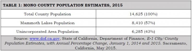
Table 2 shows population projections for the county for the next 25 years. It includes the percentage of the population 18 and older as an indicator of the number of people who may be able to drive and the percentage of the population aged 18-74 as an indicator of the number of people most likely to be driving. Over the next 25 years, the percentage of the population 18 and older is expected to increase slightly as the school age group becomes older, and the percentage of the population aged 18-74 is expected to decrease slightly as the population ages.
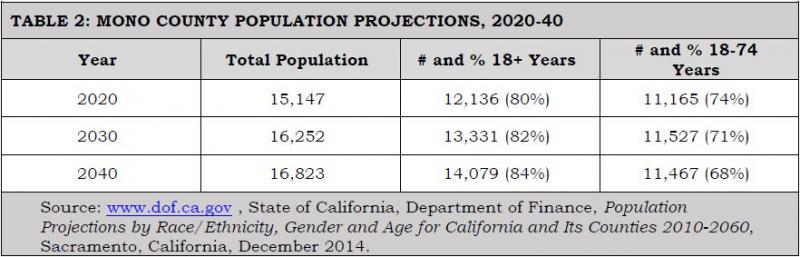
Table 3 shows population projections by community areas through the year 2040. The community projections are based on the following assumptions: that the unincorporated area will continue to house approximately 43% of the total countywide population and that the population distribution in the unincorporated community areas will remain similar to the population distribution in 2010. Antelope Valley is experiencing increasing development pressures from the Gardnerville/Carson City area; Chalfant is experiencing a similar pressure for expansion from the Bishop area; and Benton, Chalfant, and the Long Valley communities are experiencing continuing pressure from residents who work in Mammoth. As housing prices continue to rise in Mammoth Lakes, other areas of the county may experience increasing development pressure.
It is important to note that the population projections shown in Table 3 are for permanent year-round residents. Mono County, and particularly community areas such as Mammoth Lakes and June Lake, experiences much higher peak populations during periods of heavy recreational use, a factor that has a direct impact on the transportation system. Projected peak populations are utilized to determine transportation/travel demand in Mammoth Lakes and June Lake.
Assumptions: Population distribution in the county will remain as it is, with approximately 57% of the population in Mammoth Lakes, and 43% of the population in the unincorporated community areas. Population distribution in the unincorporated communities will remain as shown in Table 3. Mammoth Lakes, June Lake, Lee Vining, and Bridgeport will continue to experience much higher peak populations during periods of heavy recreational use.
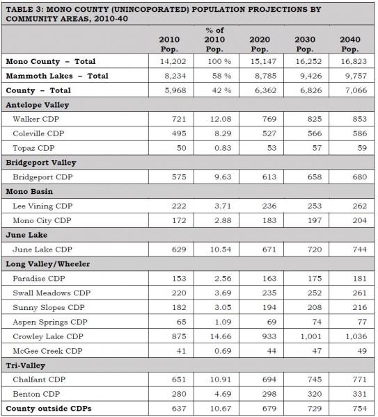
Notes: CDP is a Census designation meaning Census Designated Place. These are populated areas that lack separate municipal government but physically resemble incorporated places. In the 2010 Census, CDP boundaries were mapped based on the geographic area associated with residents’ use of the name.
Percentage of population for Mammoth Lakes and the Unincorporated Area are a percentage of the total county population. Percentagc of population for the county communities is a percentage of the total county population. Percentages for the county communities are from the 2010 U.S. Population Census and are assumed to remain similar in the future. Numbers may not equal 100% due to rounding.
Sources: www.dof.ca.gov. U.S. Census Bureau, 2010 Census, American FactFinder.
Land Use Forecasts
Unincorporated Area Development Trends
Development in Mono County communities is primarily residential with limited small-scale commercial uses serving local and tourist/recreational needs. Limited small-scale light industrial uses, such as heavy equipment storage and road yards, also occur in some county communities. Most communities also have public facilities such as schools, libraries, community centers, parks, ballfields, and government offices. County offices are located primarily in Mammoth Lakes and Bridgeport. This development pattern is not anticipated to change, due to the small scale of communities in Mono County and the lack of employment opportunities in most communities.
The Land Use Element of the county General Plan contains policies that focus future growth in and adjacent to existing communities. Substantial additional development outside existing communities is limited by environmental constraints, protected agricultural lands, a lack of large parcels of privately owned land (and lack of private land in general), and the cost of providing infrastructure and services in isolated areas. Land use policies for community areas in the county (developed by the county Regional Planning Advisory Committees) focus on sustaining the livability and economic vitality of community areas. The General Plan anticipates that growth in the unincorporated area will occur primarily in the Antelope Valley, Bridgeport Valley, June Lake, Wheeler Crest/Paradise, the Tri-Valley, and Long Valley. Traffic impacts will be most noticeable on Highways 395 and 6.
Assumptions: Development will occur in and adjacent to existing community areas that are served by existing highway systems. Traffic impacts from future development will be most noticeable on Highways 395 and 6. Town of Mammoth Lakes Development TrendsThe town of Mammoth Lakes is the county’s only incorporated community. The town is a four-season resort community with a permanent population of approximately 8,200 residents (over half of the county’s entire resident population). Vacation residences and lodging facilities accommodate a substantially larger population of second homeowners and visitors. The local economy is based primarily on tourism, especially during summer and winter months when visitation rates are highest.
The Town’s General Plan provides for extensive resort and residential development to meet recreational demand. Resort development includes lodging, commercial development, recreational facilities, and public services. The town also includes schools, a community college, a hospital, and government offices. Development in the town has been designed to accommodate peak populations that occur during high-use periods. As noted in the introduction to the Town’s General Plan:
“The ratio of permanent residents to visitors is an important element in understanding demographics in Mammoth Lakes and associated impacts. Overall, the town is prone to large fluctuations in the total non-resident population because of the seasonal nature of its tourism-dependent economy. During the winter tourist season the community and ski area require a large number of seasonal employees (more than can be filled by the full-time resident community) to meet peak service demands. As a result, the resident population increases by approximately 3,000 during the peak tourism season. The town must accommodate a much larger population when tourist populations are present. During peak tourism periods, the total number of people in town at one time exceeds 35,000 people.”
The Town of Mammoth Lakes has a defined area in which growth can occur. The Town’s General Plan provides the following information concerning the Town’s planning area and municipal boundaries:
“The Planning Area for the Town includes areas where existing or proposed facilities have a direct relationship to the current Town boundaries and services. It encompasses land in the unincorporated portions of Mono County in which the Town provides municipal services and extends from the Whitmore Recreation area on the east to the Mammoth Scenic Loop on the north. The Planning Area also includes Inyo National Forest lands located within Madera County that have their sole vehicular access through the Town of Mammoth Lakes and for which the Town provides public safety and building inspection services. The Municipal Boundary [for Mammoth Lakes] is the land contained within the incorporated limits of the Town of Mammoth Lakes. The boundary encompasses a total area of approximately 25 square miles. The Mammoth Lakes Sphere of Influence is coterminous with the municipal boundary, indicating that no additional lands are anticipated to be annexed into the municipal boundary. The Town of Mammoth Lakes adopted an urban limit policy in 1993 in order to maintain a clear delineation between the developed portions of the community and the surrounding National Forest lands. The Urban Growth Boundary policies in this plan limit residential, industrial and commercial development to those areas already designated for such uses. The ultimate size and intensity of the community would be limited to those areas not now designated for open space. The Urban Development Boundary encompasses an area of about four square miles.”
Assumptions: Development will occur within the Town’s Urban Growth Boundaries as currently designated in the Town’s General Plan. Development will occur to the buildout levels specified in the General Plan. Traffic impacts from future development will be most noticeable on Highways 395 and 203. CommutersInformation on place of work is not available from the most current U.S. Census. Historically, many county residents have not worked in the community in which they live. Residents in the Antelope Valley have commuted to work in Bridgeport and in Gardnerville, Minden, and Carson City in Nevada; residents of the Tri-Valley area have commuted to work in Bishop and Mammoth Lakes; and residents of Long Valley and June Lake have commuted to work in Mammoth Lakes and Bishop. Development in Mammoth Lakes, and rising housing prices there, have forced many residents of Mammoth to move elsewhere (Crowley Lake, June Lake, Tri-Valley, Bishop) and to commute to jobs in Mammoth Lakes.
The 2009-13 American Community Survey five-year Estimate[1] indicated 99% of workers 16 years and older residing in unincorporated Mono County worked within the state and 91% worked within Mono County. These numbers indicate a significant increase in the jobs/housing balance over 2000, when only 75% worked in the state and county (US Census 2000, Summary File 3, Tables P 31 and P32). The mean travel time to work also decreased from less than 30 minutes in 2000 to just over 16 minutes in the 2009-13 estimate. The primary means of transportation to work was a car, truck or van (67%). Of these, 54% were single-occupancy vehicles and 13% were carpools with two or more persons. Walking accounted for 14% of commuters, followed by public transportation (5%), bicycling (2.5%), and taxicab/motorcycle/other (2%). Workers from home constituted 10%.
Mono County's economy is dominated by services, retail trade, and government. Industry projections from the California Employment Development Department estimate that 85% of the job growth in Mono County between 2010 and 2020 will continue to be in services, retail trade and government (Labor Market Information, Industry Projections 2010-2020, November 2013). Major job centers are located in Mammoth Lakes (services, retail trade, government), June Lake (seasonal services and retail trade), and Bridgeport (government). Despite the availability of Commercial (C) and Mixed Use (MU) designations throughout communities in the unincorporated area, it is unlikely that sufficient jobs will develop to eliminate the need for workers to commute to jobs outside their communities.
Assumptions: The separation between jobs and housing will continue in the future due to the nature of the county's tourist-based economy. Traffic volumes will increase as this trend continues, particularly on US 395 in the southern portion of the county (June Lake, Mammoth Lakes, Crowley Lake, and Swall Meadows). Recreational/Tourist Traffic – Seasonal Use DevelopmentMono County experiences a great deal of recreational travel, both to and through the county. Most of that traffic occurs on US 395, and in the summer months on Highways 120, 108, and 89, which provide access to the area from the west side of the Sierra. Recreational traffic creates specific problems for the interregional and local transportation and circulation system, due both to the volume and type of that traffic. Winter ski weekends, particularly during peak holiday periods, result in a traffic pattern, both in communities and on highways, that simulates recurrent congestion patterns found in more urban areas. Recreational events during the summer may also create congested traffic patterns, particularly in community areas, and safety concerns with slow-moving recreational vehicles, particularly on two-lane sections of roadways. County communities are concerned about maintaining the livability of communities while providing for smoothly flowing traffic and safe traffic speeds through their communities. Recreational and tourist traffic is discussed in greater detail in the Issues and Needs section of this chapter, under the heading "Specialized Needs/Recreational Traffic."
Assumption:
As recreational use continues to expand in the Resort Corridor along US 395, visitation and travel to points of historic, cultural, and scenic beauty in other parts of the county will increase proportionately, creating a need for additional specialized transportation facilities throughout the county, including pedestrian and bicycle facilities, turnouts/vista points, rest areas, information kiosks, and parking for recreational vehicles. Safety issues associated with recreational traffic, both in communities and along highways, will remain a high priority.
Air Quality Attainment Status
Attainment StatusMono County and the Town of Mammoth Lakes meet all state and national air quality standards except for particulate matter (PM10 ) and ozone. PM10 emissions are measured at Mammoth Gateway and in the Mono Basin; ozone emissions are measured at Mammoth Gateway.
Particulate Matter (PM10)As of 2012, the county was designated as a non-attainment area for the state particulate matter (PM10) standard. Mono Basin and Mammoth Lakes are also designated as non-attainment areas for the national particulate matter (PM10) standard. Particulate matter (PM10) in the Mono Basin results primarily from dust from the exposed lakebed of Mono Lake; levels are higher on the north shore of Mono Lake than in Lee Vining due to the prevailing wind conditions. PM10 in Mammoth Lakes is a result primarily of wood burning and re-suspended road cinders during the winter.
PM10 concentrations in the Mono Basin have remained relatively stable between 2000 and 2012 with much lower concentrations in Lee Vining and higher concentrations on the north shore (see www.arb.ca.gov, PM10 Trends Summary). PM10 concentrations in Mammoth Lakes have declined significantly since the early- to mid-1990s (see www.arb.ca.gov, PM10 Trends Summary). Based on available data, Mammoth Lakes has not exceeded the national standard for PM10 since 1993, except for two times in 2013-14 due to wildfire, and has sharply reduced the number of days it exceeds the state standard (from 62.4 days in 1993 to 15 days in the 2013-14 winter season to three days in 2014-15 winter season). In 2013-14, 10 of the 15 exceedances were due to wildfire events, and in 2014-15 all were due to wildfire events.[2]
OzoneIn 1991, Mono County was designated as a non-attainment area for the state ozone standard. Ozone data collected by the State Air Resources Board in Mammoth Lakes indicate that ozone concentrations have decreased in Mammoth in recent years; the area has exceeded the one-hour State Standard only a few times during the most-recent period for which data are available, but it has exceeded the eight-hour State and Federal Standard more often [see www.arb.ca.gov, Ozone Data Summary (1988-2004)]. In the past, the State Air Resources Board concluded that ozone exceedance in the Great Basin Air Basin (Alpine, Inyo and Mono counties) was caused by transport from the San Joaquin Valley Air Basin; the Great Basin Unified Air Pollution Control District adopted an Ozone Attainment Plan for Mono County that identified the county as an ozone transport area, and required the adoption of a New Source Review Rule requiring Best Available Control Technology for emissions over 25 tons per year.
Compliance with State Implementation Plan (SIP)Regional transportation plans must conform to the requirements of the State Implementation Plan (SIP) for air quality control. The requirements for conformity apply "…in all nonattainment and maintenance areas for transportation-related criteria pollutants for which the area is designated nonattainment or has a maintenance plan" [Title 12, Section 1203 (b)(1)]. In Mono County, transportation-related criteria pollutants occur only in Mammoth Lakes (PM10 emissions resulting primarily from re-suspended road cinders and auto emissions). As a result, the Air Quality Management Plan for the Great Basin Unified Air Pollution Control District (GBUAPCD) and the State Implementation Plan (SIP) for Mono County do not include any transportation-related requirements other than for the town of Mammoth Lakes. The following section addresses plans and policies adopted by the Town of Mammoth Lakes to address air quality mitigation. Those plans and policies (including the 1990 Air Quality Management Plan, Air Quality Maintenance Plan and Redesignation Request (2014), and Municipal Code Chapter 8.30 Particulate Emissions Regulations, the Mammoth Lakes Revised Transportation and Circulation Element, and the Mammoth Lakes Transit Plan) are incorporated by reference in this RTP (see Chapter 1, Documents Incorporated by Reference).
Transportation Related Air Quality MitigationIn compliance with GBUAPCD requirements, and in consultation with the GBUAPCD and other agencies, the Town adopted an Air Quality Management Plan (AQMP) prepared by the GBUAPCD, including Particulate Emissions Regulations (Chapter 8.30 of the Municipal Code) in 1990.
Prior to 1990, the Town recorded 10 violations of the federal 24-hour PM10 standard. Following implementation of the plan in 1990, there was an immediate decline in PM10 emission; since 1994, despite continued growth, no further violations of the national standard have occurred. As a result, in 2014, an Air Quality Maintenance Plan and PM10 Redesignation Request was adopted to update the 1990 Air Quality Management Plan for the Town of Mammoth Lakes. The 2014 Plan reviews the background of the 1990 plan, the measures implemented as a result of that plan and their effectiveness, and changes to clean air regulations since the adoption of the 1990 plan. The 2014 Plan then recommends maintenance measures and requests that the Town of Mammoth Lakes be redesignated as in attainment for the federal PM10 standard.
The 2014 plan updated Section 8.30.100B of the town Municipal Code that sets a peak level of VMTs (vehicle miles traveled) at 179,708 per day within the Town, and directs that the Town review development projects in order to reduce potential VMTs. A second budget of 66,452 VMT was established for a peak winter day in the area outside of the town boundaries (unincorporated county), but inside the boundaries of the Mammoth Lakes PM10 planning area (Mammoth Air Basin). Methods to reduce VMTs include circulation improvements, pedestrian system improvements, and transit improvements. The 2014 Plan also requires the Public Works director to undertake a street-sweeping program to reduce particulate emissions caused by road dust and cinders on Town roadways.
The success of the existing control measures demonstrates that PM10 levels have been reduced and will be reduced to a sufficient degree that contingency measures are not required. Nonetheless, additional measures have been incorporated into the AQMP to assist in further reductions of PM10 levels with the goal of improved compliance with the California Ambient Air Quality Standard for PM10. These measures include amending the Town of Mammoth Lakes Particulate Emissions Regulations to match GBUAPCD Rule 431, requiring all wood-burning fireplaces and stoves, whether certified or not, to comply with no-burn days.
The Town’s Transit Plan and the Draft Mobility Element of the Town’s General Plan contain policies that are intended to increase transit ridership and reduce automobile usage. Recommended service improvements include expansion of winter transit services (peak period) for skiers and commuters, airport shuttle service, increased community transit services, year-round fixed-route services, and Dial-A-Ride services in Mammoth. Policies in the Transit Plan and Draft Mobility Element also emphasize restricting automobile parking spaces in favor of expanding the existing transit system and direct ski lift-access facilities, and incorporating transit and pedestrian facilities into existing and future developments, in order to reduce vehicle trips and improve air quality.
Assumptions: Increased traffic volumes will result in increases in pollutant emissions, particularly PM10. This will continue to be a problem in Mammoth Lakes, especially during congested periods in the winter when inversion layers trap the pollutants close to the ground. Improved transit and pedestrian services, including the incorporation of transit and pedestrian facilities into existing and future development, will help address air quality issues in Mammoth Lakes. Transportation-related air emissions will not impact other community areas in the county.Performance Conditions (LOS)
Performance conditions, or Levels of Service (LOS—see Glossary), on state and federal highways are set by Caltrans systems planning. The emphasis in District 9, which includes Inyo and Mono counties and eastern Kern County, is on maintaining and improving the interregional transportation network. Higher priorities are given to major improvements on principal arterial routes than to minor arterials or major collectors. Table 4 shows Caltrans’ planned LOS for state and federal highways in Mono County. Caltrans has been working to improve mobility on US 395, the route on which performance conditions are affected the most by traffic levels.
Performance conditions on local streets are generally not a concern since local streets typically carry only local traffic; state and federal highways serve as the main access to each community in the county and carry the greatest amount of traffic.
Assumptions: Performance conditions, or LOS, on the County’s highway system will remain as shown in Table 4, but will be re-evaluated following issuance of new guidance regarding performance measures and LOS alternatives under the California Environmental Quality Act.
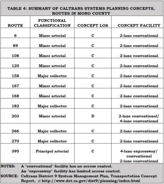
Capital Operations and Maintenance Costs
Operation and maintenance costs are addressed in Chapter 6: Financial Element.
Cost of Alternatives
The existing transportation system in Mono County includes the highway and roadway system, transit services, aviation facilities, and non-motorized facilities (generally used by locals and visitors to reduce short trips). Alternatives to the existing transportation system in the county are limited by the county’s isolation, topography, extreme weather conditions, small population, large distances between communities, large amounts of publicly owned land, and environmental constraints to developing additional facilities outside existing developed areas. Due to these factors, the existing highway and roadway system will continue to be the major component of the transportation system in the county. Development of alternative routes for highways and roadways during the 20-year time frame of this RTP is unlikely due to lack of demand for additional roads, topography, large amounts of publicly owned land, and environmental constraints to developing additional facilities outside developed areas.
The existing transportation system in the county (highway/roadway system, transit services, aviation facilities, non-motorized facilities) has been designed to accommodate increasing demand for those facilities and services over the 20-year time frame of this RTP. Demand for additional alternative methods of transportation, other than expanding and improving those currently existing in the county, is not anticipated to occur over the 20-year time frame of this RTP, given the constraints noted above.
Assumptions: It is assumed that alternatives to the existing transportation system in Mono County will not be developed during the 20-year time frame of this RTP. The Cost of Alternatives is not a relevant issue for this RTP.Time Frames
Assumptions: The short-term time frame for planning purposes for the Mono County RTP is 10 years. The long-term time frame for the Mono County RTP is 20 years.Environmental Resources of Concern
Mono County’s economy is dependent on natural resource-based recreation and tourism. Projects that detract from or degrade those natural resources are a concern. Environmental resources of special concern in relation to transportation planning and projects include scenic resources, air quality, noise, and wildlife and wildlife habitat, particularly Bi-State sage-grouse which was proposed for designation as threatened under the Endangered Species Act at one time, with critical habitat potentially covering more than 80% of private property in Mono County.
Assumptions: Mono County, the Town of Mammoth Lakes, Caltrans, and the USFS are proactive in designing and implementing projects and programs that avoid or minimize impacts to environmental resources in the county. This will continue to be a focus of project development, implementation, and management.
Complete Streets
State Law (AB 1358) requires local governments to include provisions for Complete Streets in their general plans. The Act states: “In order to fulfill the commitment to reduce greenhouse gas emissions, make the most efficient use of urban land and transportation infrastructure, and improve public health by encouraging physical activity, transportation planners must find innovative ways to reduce vehicle miles traveled (VMT) and to shift from short trips in the automobile to biking, walking and use of public transit.”
The Circulation Element must “plan for a balanced, multi-modal transportation network that meets the needs of all users of the streets, roads, and highways for safe and convenient travel in a manner that is suitable to the rural, suburban, or urban context of the general plan.” Caltrans defines complete streets as “a transportation facility that is planned, designed, operated and maintained to provided safe mobility for all users, including bicyclists, pedestrians, transit vehicles, truckers, and motorists, appropriate to the function and context of the facility.”
Assumptions: Mono County communities and the Local Transportation Commission (LTC) have been proactive in seeking transportation improvements that add to the livability of local communities. Within communities, including the town of Mammoth Lakes, Mono County's tourist-based economy can be enhanced by flexible highway designs, better facilities for pedestrians and cyclists, adequate parking facilities, reduced travel speeds, reduction of vehicle trips, and creating an environment that does not favor the automobile over other transportation modes. This will continue to be a focus of project development, implementation, and management.
Issues and Needs
Operational Issues, Including Emergency Preparedness
Emergency Response
The Mono County Emergency Operations Plan (EOP) and the Town of Mammoth Lakes Emergency Operations Plan (EOP), developed by the county and town Offices of Emergency Services, outline how emergency workers should respond to major emergencies within the county and the town. They are links in the chain connecting the detailed standard operating procedures (SOPs) of local public safety agencies to broader state and federal disaster plans. They address potential transportation-related hazards, including potential hazards from earthquakes, volcanic eruptions, floods, and hazardous materials transport. They also address emergency preparedness and emergency response for the regional transportation system, including the identification of emergency routes. Alternative access routes in Mono County are limited primarily to the existing street and highway system due to the terrain and the large amount of publicly owned land. However, the County has developed alternative access routes for community areas that had limited access (i.e., North Shore Drive in June Lake, the Mammoth Scenic Loop north of Mammoth Lakes). The County also consults with Cal Fire for emergency access requirements for new development in the State Responsibility Areas that cover most of the private property in Mono County. GIS mapping of the county and the town will enhance and support alternative route awareness for emergency responders and incident locations.
Aviation Safety
In past years, a number of airplanes have crashed in the high elevations of the Sierra. As air traffic increases, the likelihood of further aircraft accidents in the more inaccessible areas of the high country also increases. The FAA recently installed an instrumentation system at the Mammoth Yosemite Airport intended to help reduce the numbers of accidents in that area. Planned improvements at all airports in the county (e.g., lighting, fencing, taxiways, runway overruns) will increase safety at all airports.
RoadwaySafetyThe California Highway Patrol (CHP) tracks collisions in Mono County (see www.chp.ca.gov, SWITRS). Between 2001 and 2010, Mono County had an average of five fatal collisions per year with an average of five persons killed per year. During the same period, an average of 116 injury collisions per year occurred with an average of 171 persons injured. Most collisions and injuries occur from November through February and June through July, the periods of heaviest tourist visitation.
Wildlife collisions are a concern throughout the county. Figure 1 indicates collision points on US 395 that have been recorded by law enforcement agencies and Caltrans District 9, and Figures 2 and 3 indicate animal mortality by density. There is a perception of high collision rates in North County, and clear evidence of high collision rates in South County between SR 203 and Crowley Lake Drive. There is interest in projects to reduce these collisions and animal mortality rates.
Cell Phone ServiceCell phone service is poor in certain areas of the county. Due to the isolated nature of much of the highway mileage in the county and the extreme weather conditions experienced throughout the year, there is a need to ensure that adequate cell service exists throughout the county. Additional cell towers have been installed over the past several years to improve cell service in areas lacking service or with poor service; additional towers may still be necessary. Specific policies for broadband and related communication infrastructure have been developed in the Mono County General Plan Circulation Element.
FIGURE 1: 2010-13 Animal Mortality Locations on the State Highway system
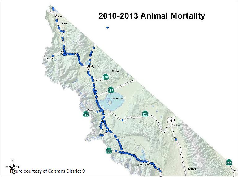
FIGURE 2: Animal Mortality Density on State Highways – North County
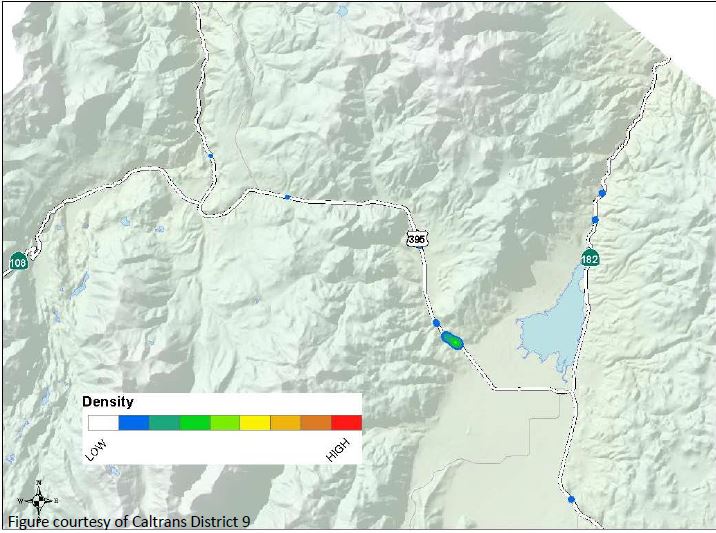
FIGURE 3: Animal Mortality Density on State Highways – South County
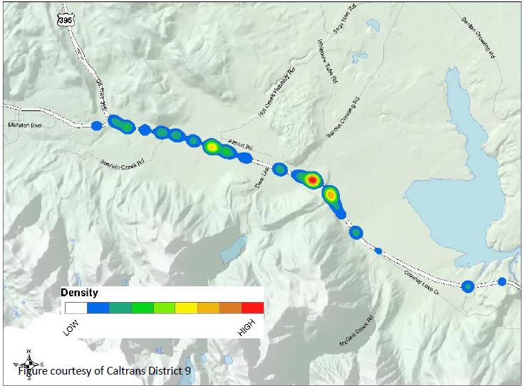
Additional transportation-related safety issues include the following:
- The potential for avalanches is a concern in community areas throughout the county, i.e., Twin Lakes, Virginia Lakes, Lundy Lake, June Lake, and Long Valley, along US 395 in the areas just north of Lee Vining, east of McGee Mountain, and at Wilson Butte between Mammoth Lakes and June Lake, and along SR 158, the June Lake Loop. In June Lake, North Shore Drive provides an alternative route into June Lake that is intended to mitigate the impacts of potential avalanches along SR 158. The LTC has recently authorized an examination of seasonal road closure policies as part of the 2014-15 proposed Overall Work Program. Of particular concern is the potential recreational access that can be provided during low-snow years, together with concerns for ensuring traveler safety.
- Increased levels of truck traffic on state highways are a safety[1] concern. US 395 and 6 are part of the National Truck Network and experience increasing truck traffic; this truck traffic can impact residential communities along these routes. In 2006, medium- and heavy-duty trucks comprised 25% of all traffic within the corridor (this and all further information on truck traffic is from Katz, 2006). Five-axle single- unit trucks made up approximately 80% of all truck traffic. The majority of southbound trucks used US 395 (61%) instead of US 6 (31%). The majority of northbound trucks used US 395 (59%) instead of US 6 (33%). Truck volumes are generally higher in the southbound direction and the average peak period for truck traffic is the midday period between 10 am and 3 pm. Safety concerns focus on the impact of oversized trucks on the safety and capacity of two-lane highway sections and the lack of paved shoulders and adequate sight distances. Narrow shoulders are a concern if vehicles must pull over for emergencies. Narrow shoulders are also less desirable for bicyclists, especially when being passed by large trucks. The recent four-laning of US 395 in various parts of the county has mitigated safety issues in those areas but concerns about truck traffic remain significant in the Tri-Valley on US 6, a two-lane road with no shoulders. The 2006 Katz study is anticipated to be updated in the near future to provide current truck traffic data and projections.[2]
- Recreational vehicle (RV) traffic creates the same safety concerns as trucks. Recreational vehicle traffic decreased from 13.4% of all traffic in the county in 1989, to 3.2% in 2000, to 1.7% in 2011 (Caltrans, US 395 Origination and Destination Report, Year 2011). A contributing factor to reduced RV use may have been the increase in average California gas prices in 2011.
- Hazardous materials spills are a concern throughout the county. The potential for such accidents is highest on Highways 395 and 6, where truck traffic is greatest. Trucks haul a variety of commodities through Mono County, with the greatest number hauling miscellaneous manufacturing products, general freight, food and similar products, farm products, and empty containers (Katz, 2006). Approximately 7% of truck traffic carries petroleum and coal products or chemicals (Katz, 2006). The Mono County Integrated Waste Management Plan contains policies to address hazardous waste spills. The Mono County Emergency Operations Plan (EOP), prepared by the Office of Emergency Services, also addresses emergencies resulting from hazardous materials spills.
- Hospitals in Mono County have limited capacity for multi-casualty incidents, and may require transport of the victims to facilities outside the county. Many accident victims with critical injuries are also transported to facilities outside the county. Access to certain areas of the County may be limited seasonally or due to weather, fire, or other such events.
Existing Regional/Interregional Transportation System
Overview
Mono County is a rural county located on the eastern side of the Sierra Nevada. The county has an area of 3,103 square miles and in 2013 had an estimated total population of 14,625 persons. The county has one incorporated area, the town of Mammoth Lakes, which had an estimated population of 8,410 in 2015. The county's other communities are scattered throughout the area, primarily along Highways 395 and 6.
Approximately 94% of the land in the county is owned by public agencies; approximately 88% is federally owned and is managed by the USFS and the Bureau of Land Management. The limited private land base restricts the growth potential for permanent residents but also provides the foundation for the county's tourist-based economy. The spectacular scenery in the county and the many varied recreational opportunities provide a tremendous recreational draw, especially for people from Southern California.
The transportation system in Mono County is typical of many rural counties. Private automobiles are the primary mode of moving people: trucks are the primary mode of moving goods. Throughout the county, the transportation system is a key support system that sustains the social, economic and recreational activities in the county. The terrain, the weather and the lack of a sufficient population base have limited other modes of regional transportation. These factors continue to limit the development of alternative regional transportation systems in the county.
Highway System
The state and federal highway system provides major access to and through Mono County, connecting communities in the county and providing access to and from the county.
US 395 is the major transportation route in the county. It connects the Eastern Sierra with Southern California and with the Reno/Tahoe region in northern Nevada. US 395 is also Main Street in Lee Vining, Bridgeport, Walker, Coleville, and Topaz, and provides access to the immediately adjacent communities of June Lake, Crowley Lake, McGee Creek, Long Valley, Sunny Slopes and Tom’s Place.
US 6, from the Inyo County line north of Bishop to the Nevada state line, connects the Tri-Valley communities of Benton, Hammil, and Chalfant to Bishop and Inyo County. US 6 is also Main Street in the Tri-Valley communities.
SR 89 provides access from US 395 to Monitor Pass and is closed in the winter.
SR 108 provides access from US 395 west to Sonora Pass and is closed in the winter.
SR 120 provides access from US 395 west to Tioga Pass at Yosemite National Park and east to Benton. The western segment is closed in the winter and the eastern segment may also be closed briefly. Within Yosemite, the road is under the jurisdiction of the National Park Service and is labeled Highway 120 (rather than State Route 120).
SR 158, the June Lake Loop, provides access from US 395 to the community of June Lake and is Main Street throughout the June Lake Loop. A segment of the loop is closed in the winter.
SR 167 provides access from US 395 to the Nevada State Line, north of Mono Lake, and to Mono City.
SR 168 provides access from US 395 at Big Pine in Inyo County north via Westgard Pass to Oasis in the southeast corner of Mono County.
SR 182 provides access from its junction with US 395 in Bridgeport northeast to the Nevada state line and provides the Main Street access to a portion of the community of Bridgeport.
SR 203 provides access west from US 395 to Mammoth Lakes to Mammoth Mountain Ski Area, serving a portion of the town as Main Street and ending near Minaret Vista Point at the Madera County line.
SR 266 provides access through Oasis in the southeast corner of the county.
SR 270 provides access east from US 395 to near Bodie State Historic Park and is closed in the winter.
US 395 is the principal route to and through Mono County. It is the only direct route to and through the county for the shipment of goods and materials. It is also the only route suitable for emergency purposes and the principal route to the county's many recreational and tourist attractions.
US 395 extends approximately 120 miles from northwest to southeast Mono County. It provides regional transportation connections to Reno and Lake Tahoe to the north, the Bay Area and the Central Valley to the west, and the greater Los Angeles area to the south. In 2014, US 395 carried annual average daily traffic (ADT) volumes of ranging from 3,550 vehicles at the Nevada state line at Topaz to 8,300 vehicles traveling southbound at the junction with SR 203. Peak month ADT volumes varied from 11,500 at the northbound junction with SR 203 to 4,600 at Sonora Junction (SR 108).
US 395 in Mono County is identified as a regionally significant part of the Interregional Road System (IRRS), as a lifeline route and as part of the National Truck Network on the National Highway System (NHS), which authorizes use by larger trucks and provides access to facilities off the route. The majority of US 395 in Mono County is also identified as a freeway/expressway.
US 6 also provides regional transportation connections in Mono County. It extends over 30 miles in Mono County – toward Bishop in the south and Nevada to the north and east. In 2014, annual ADT volumes on US 6 varied from3,500 vehicles at the junction with US 395 in Bishop to 890 vehicles at the northbound junction with SR 120 in Benton.
US 6 is a popular alternate route north when poor weather affects conditions on US 395. US 6 is identified as part of the National Truck Network on the National Highway System (NHS) and is on the eligible Interregional Road System (IRRS).
SR 120 extends approximately 75 miles through Mono County, from Tioga Pass in Yosemite National Park east to Benton. Other routes that connect to US 395 include: SR 89 (Monitor Pass), SR 108 (Sonora Pass), SR 167 (to Hawthorne, Nevada), SR 158 (the June Lake Loop), SR 270 (to Bodie), SR 182 (from Bridgeport to Yerington, Nevada), and SR 203 (to Mammoth). SR 168 and SR 266, connecting Big Pine in Inyo County and Nevada, cross the extreme southeast corner of the county.
Tioga Pass (SR 120), Sonora Pass (SR 108), Monitor Pass (SR 89) and SR 270 to Bodie are all closed during winter, as is the northern portion of SR 158, SR 203 from four miles east of the Mono County boundary with Madera County, and the portion of SR 120 between US 395 and Benton. During periods of heavy snowfall, SR 167 and the southern portion of SR 158 may also be closed. The LTC is examining seasonal road closure policies, and will seek local input on policy development. Of particular concern is the potential recreational access that can be provided during low-snow years, together with concerns for ensuring traveler safety. Figure 4 shows the existing highway system in the county.
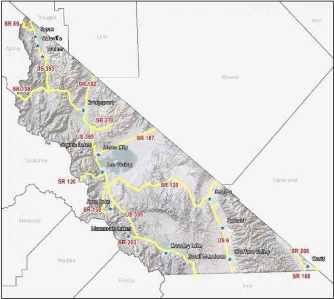
Interregional Travel Demand and Corridor Needs
US 395US 395 is, and will remain in the long-term, the major access to and through Mono County and the major transportation route in the area. It connects the Eastern Sierra with Southern California and with the Reno/Tahoe region in Northern Nevada. The primary needs for US 395 throughout Mono County are maintaining four lanes from the Inyo/Mono county line to Lee Vining; allowing for passing lane improvements to the conventional two-lane highway north of Lee Vining; safe winter access countywide; adding adequate shoulders as a priority to enable safe pedestrian and bike use, as well as increased motorist safety including potential separated-grade wildlife crossings; improved system safety and maintenance; and the development of sufficient revenue sources to meet these needs.
US 6
US 6, from the Inyo County line north of Bishop to the Nevada state line, provides regional/interregional transportation connections and is a trucking route between Southern California, Reno, and the western mountain states (Washington, Idaho, Montana). Caltrans has identified the primary purpose of the route as interregional traffic (largely trucks). The route is currently a maintenance-only route with some improvements planned for the future as traffic volumes increase and for multi-modal safety, including on-going shoulder-widening projects. The major local concerns about US 6 are safety during the periodic dust storms that occur in the area and speeds through community areas. Dust from plowed fields and from the deposits from flash floods blows across the highway, decreasing visibility. Some local landowners are working with the Great Basin Unified Air Pollution Control District to develop plans to mitigate dust problems from agricultural fields. Since the area is subject to flash floods, little can be done about dust resulting from flood deposits. An ITS dust sensor warning system to alert drivers in advance of arriving at dust storm locations might also be considered. Vehicles traveling at high speed through community areas are also a concern, both for local traffic trying to access the highway and for pedestrian safety. Vehicle speed-feedback signs have recently been installed, and there is currently interest in pursuing a Safe Route to School access across US 6 in Benton.
State Routes 120, 167, 182, 108, and 89
The remaining state highways in the county provide interregional access east and west from US 395 to Nevada and to the western side of the Sierra. State Routes 120, 108, and 89, which cross the Sierra in high mountain passes, are closed in winter. The main concern on these routes is continued adequate maintenance, including timely road openings following winter closures and intermittent access during low-snow years.
Mountain Passes
There is some interest in attempting to keep the mountain passes (Tioga, Sonora, and Monitor) open as long as possible, including opening the passes as soon as practical, in order to increase access from the west and provide an economic boost to local communities. The County coordinates with Caltrans and Yosemite National Park to keep Tioga Pass open as long as possible. Residents in communities near Sonora and Monitor passes are also interested in keeping those passes open as long as possible.
Average Daily Traffic Volumes
Table 5 shows Average Daily Traffic (ADT) volumes on Mono County Highways in 2009 and 2014. Between 2009 and 2014, traffic volumes increased on many of the County’s highways, particularly on the county’s most heavily traveled routes (i.e., US 395, US 6, and SR 203).
[1] According to comments by Caltrans District 9 in Dec. 2015, truck traffic safety issues have not been identified based on system data.
[2] Note: The Mono County Board of Supervisors adopted slightly different language in the Mono County General Plan Circulation Element for this bullet point. See the “2015 Circulation Element Errata Sheet.”
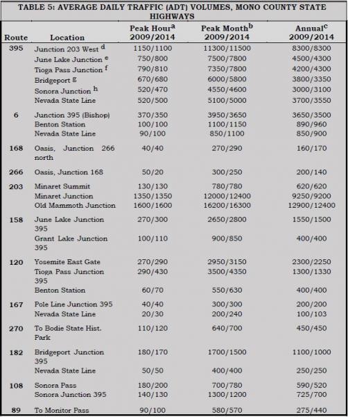
Table 5 Notes:
- These are estimated figures.
- The peak month ADT is the average daily traffic for the month of heaviest traffic flow.
- Annual average daily traffic is the total traffic volume for the year divided by 365 days. Some routes are regularly closed for one month or more during winter; ADT figures for those routes reflect travel when the route is open. Routes regularly closed during the winter include the following:
SR 89 – Monitor Pass, Jct. US 395 to Jct. SR 4, 17.5 miles.
SR 108 – Sonora Pass, six miles east of Strawberry to seven miles west of Jct. US 395, 35 miles.
SR/Highway 120 – Tioga Pass, Crane Flat to five miles west of Jct. US 395, 55 miles.
SR 120 – Mono Mills Road, two miles east of Jct. US 395 to six miles west of Jct. US 6, 37.6 miles.
SR 158 – June Lake Loop, Powerhouse to north Jct. US 395, 8.6 miles.
SR 203 – Mammoth Lakes Road, Mono/Madera county line to one mile east.
SR 270 – Bodie Road, Jct. US 395 to Bodie, 9.8 miles.
- Reflects traffic turning into Mammoth. Counts on 395 going north from 203 are lower.
- Reflects traffic turning into June Lake. Counts on 395 going north from 158 are lower.
- Reflects traffic from SR 120 north on 395 toward Lee Vining.
- Reflects traffic going north out of Bridgeport.
- Reflects traffic going north from the Sonora Junction
SOURCE: Caltrans 2009 and 2014 Traffic Volumes on California State Highways.
Specialized Needs
Recreational TravelMono County experiences a great deal of recreational travel, both to and through the county. Most of that traffic occurs on US 395. In the summer, additional traffic occurs on State Routes 120, 108, and 89, which provide access to the area from the west side of the Sierra. Recreational traffic creates specific problems for the local transportation and circulation system, due both to the amount and type of that traffic. Winter ski weekends, particularly during peak holiday periods, result in a congested traffic pattern, both in communities and on the highway, which simulates rush-hour traffic patterns found in more urban areas. Recreational events during the summer may also create congested traffic patterns, particularly in community areas.
Recreational travelers have special needs, such as turnouts/vista points, rest areas, and information about local recreational areas, interpretive information, lodging, and travel routes. Recreational travelers also create safety concerns on local and state highways and roads; sightseers often travel slowly, disrupting the traffic flow, and may stop along the road to enjoy the view or take photos, creating a hazardous situation. Recreational vehicles (RVs) travel slowly on the many steep routes in the area, disrupting traffic flow, particularly in areas where the road is only two lanes. In community areas, RVs often have difficulty parking or use more than their share of limited parking spaces. RVs account for 1.7% of the traffic in Mono County on US 395, a decline from a high of 13.4% in 1989 and 3.2% in 2000 (Caltrans, US 395 Origination and Destination Report, Year 2011).
Results from the 2011 US 395 Origination and Destination Report showed some changes since the prior two reports, i.e.:
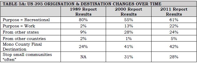
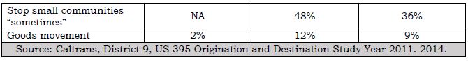
Many of the needs of recreational travelers have been addressed by recently completed or ongoing projects. The four-laning of US 395 to Lee Vining has eliminated many of the problems resulting from slow-moving vehicles. Transportation enhancement projects related to the Eastern Sierra Scenic Byway have provided turnouts and information for travelers. The June Lake, Mono Basin, and Bodie Hills Transportation Plans address parking in community areas and transportation linkages between communities and recreational areas.
Disabled PersonsThe Americans with Disabilities Act (ADA) requires public and private transportation projects to comply with the ADA. This requires that transportation facilities are accessible to disabled persons; e.g., pedestrian facilities, parking areas, turnouts, kiosks, etc. must be wheelchair- accessible. All transit services must also comply with the requirements of the ADA. The ADA requires the availability of wheelchair lift-equipped fixed-route buses and door-to-door service for disabled persons who cannot use the fixed-route service. ESTA buses are equipped with wheelchair lifts and also provide door-to-door demand-responsive service.
Goods Movement
Goods movement to and through Mono County occurs on the interregional highway system; i.e., US 395 and US 6. There are no railroads in the county and no air freight services. As noted previously, US 395 in Mono County is identified as part of the National Truck Network on the National Highway System (NHS), which authorizes use by larger trucks and gives them access to facilities off the route. US 395 provides regional transportation connections and truck access between Southern California and Reno, Nevada.
US 6, from the Inyo County line north of Bishop to the Nevada state line, provides interregional transportation connections and is a trucking route between Southern California and the western mountain states (Washington, Idaho, Montana). It is also identified as a part of the National Truck Network, and Caltrans has identified the primary purpose of the route as interregional traffic (largely trucks).
In 2006, medium- and heavy-duty trucks comprised 25% of all traffic within the corridor (this and all further information on truck traffic is from Katz, 2006). Five-axle single-unit trucks made up approximately 80% of all truck traffic. The majority of southbound trucks used US 395 (61%) instead of US 6 (31%). The majority of northbound trucks used US 395 (59%) instead of US 6 (33%). Truck volumes are generally higher in the southbound direction and the average peak period for truck traffic is the midday period between 10 am and 3 pm. The 2011 Origination and Destination Report conducted by Caltrans found that tractor trailers totaled 9.1% of total vehicles, a decrease from 11.5% in 2000.
Local Corridor Needs
OverviewLocal corridor needs include state highways that serve primarily local traffic (i.e., they do not provide interregional connections), County roads, city streets, and public roads operated by various other local, state, and federal agencies. Table 6 shows the mileage of maintained public roads in Mono County. Local corridor needs in the town of Mammoth Lakes are discussed later in this chapter under the heading Town of Mammoth Lakes.
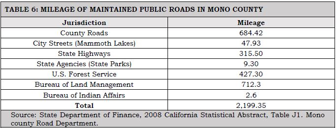
SR 203 provides access from US 395 to Mammoth Lakes, to Mammoth Mountain Ski Area, and continues as a road owned and operated by the USFS to Reds Meadow and Devils Postpile in the summer months. Congestion on 203 in Mammoth Lakes and between town and the ski area continues to be a problem in winter, resulting in adverse air-quality impacts, primarily from resuspension of road dust and cinders and auto emissions. Traffic is also heavy during certain periods in the summer. Congestion, and the resulting air-quality impacts, is the major concern on SR 203.
State Route 158SR 158, the "June Lake Loop,” provides access from US 395 to the community of June Lake. There are operational and safety concerns on this route, particularly in the Village and Down Canyon areas of June Lake. These concerns focus on easing congestion in the Village by providing alternate routes; providing for alternatives to the automobile; and providing safer routes for non-motorized forms of transportation.
County RoadsThe county currently has 684.42 miles of County-maintained roads (County Road System Maps are included in Appendix E). Of that maintained mileage, 179.07 miles are paved, 168.47 miles are plowed in the winter, and 197.87 miles traverse National Forest lands. Although most of the County roadway system is already established, there remains a need for new facilities. These needs are generally addressed in the community policy section (e.g., June Lake) in order to complete the circulation system, provide for emergency access, avoid congestion and provide for continued growth. The main access to all communities in the county is state highways, i.e., US 395, SR 158, and US 6.
In addition to the County roads, there is an extensive network of private and federally controlled roads in the county, many of them unimproved. The federal roads, on lands managed by the USFS and BLM, are mostly unmaintained dirt roads that receive limited use from logging trucks and off-highway vehicles (OHVs). The USFS and the BLM have developed management plans for OHV use. The private roads in the county are mostly in community areas; many of them are substandard roads that do not meet the county Roadway Standards and as a result have not been accepted into the county Roadway System.
Substandard roads are a particular problem in June Lake. In 1981, the Mono County Public Works Department recognized the Loop's existing constraints to roadway construction and developed a special set of arterial/commercial and collector/residential road standards tailored to meet those constraints. These standards permit lower design speeds and narrower roads than in other areas of the county.
Major development projects have been able to comply with these standards, however the costs of upgrading older roads will continue to preclude their improvement and ultimate acceptance into the County maintenance program. This is true throughout the county. Property owners on private roads will continue to bear all maintenance costs, as private roads do not qualify for state and federal maintenance funding.
On County roads, the primary needs for local streets and roads are snow removal, regular pavement maintenance and major rehabilitation. Heavy snowstorms, rapid freeze-thaw deterioration and heavy visitor traffic create an unusually high demand for snow removal and regular annual maintenance. The Public Works Department maintains and updates annually a snow-removal priority list for County roads. The Mono County Road Department currently provides road surface and shoulder repair, signing, striping and snow removal, as well as minor and major improvements such as road surfacing and alignment improvements. Operating revenues that support these services are provided through various state and federal revenue- generating programs, including state gas taxes, vehicle code fines, timber receipts, federal and secondary funds, transportation allocations, and motor vehicle license fee taxes. Due to dwindling revenues for road maintenance, Mono County is implementing a regional asset management strategy to ensure efficient expenditure of limited resources in maintaining the local road system.
The potential impacts of large-scale future development on the County road system continue to be a major concern. Traffic volumes of future development may impact portions of the existing road system. There is a need for mitigation of future impacts to the transportation system and for a standardized means of assessing potential impacts from future projects.
Roads on Native American LandsThe transportation systems serving the Bridgeport Indian Colony and the Benton Paiute Reservation include the State Highway System, County roads, tribal roads, and roads managed by the Bureau of Indian Affairs. Transportation needs for each location include road upgrades, ongoing road maintenance, and new road construction to serve existing and proposed development (see Nelson\Nygaard, Tribal Transportation Needs Assessments).
Maintenance of the Existing Regional/Interregional Transportation System
Maintenance of the existing regional and interregional transportation system is discussed in the Action Element.
Traffic Demand, Mono County
Traffic demand projections for the unincorporated areas of Mono County are based on potential trip generation rates of projected residential land uses. The methodology used to compute those projections is explained in detail in Appendix A – Traffic Demand Projections, Unincorporated Areas. Table 7 summarizes the data presented in Appendix A.
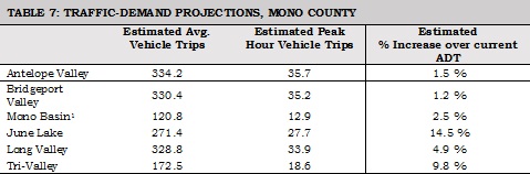
The analysis in Appendix A notes that the estimated increases over current Average Daily Traffic (ADT) figures are not significant increases. North Shore Drive into June Lake is expected to help mitigate the larger expected traffic increase in June Lake.
Demand Management Strategies
Transportation Demand Management (TDM) refers to measures designed to reduce vehicle trips, trip lengths, and congestion. TDM encourages wider use of transit, vanpools, carpools, and other alternatives to the single-occupant automobile. TDM measures provide alternatives to large investments in new highway and transit systems, which are limited by lack of money, adverse community reactions, and other factors. TDM measures are designed to modify travel demand patterns, resulting in lower capital outlays. They may be implemented within a short time frame and evaluated quickly. Several policy issues arise in determining the extent to which TDM may be used to reduce congestion, including the effectiveness of voluntary vs. mandatory measures, and the need to apply them only to new development or to all employers of a specific size.
The transportation system in Mono County does not experience severe congestion except in limited areas, and at limited times. Due to a number of factors, some TDM measures are not particularly viable options in the unincorporated areas of Mono County at this time. Bicycling is generally not a year-round option for commuters in many areas of the county due to the long distances traveled and severe winter weather conditions. There is some potential in county communities to increase pedestrian facilities; the County is pursuing funding to convert county communities (i.e., Crowley Lake, Lee Vining, June Lake, Bridgeport, and Walker/Coleville) to more livable/walkable communities.
Mammoth Lakes is committed to becoming a multi-modal community where automobile usage is minimized due to efficient pedestrian and transit systems. The Town has downsized roads to make room for sidewalks and bike lanes, increased transit facilities, and developed park-and- ride facilities. In addition, the Town has greatly expanded its trail system for pedestrians, bicyclists, and Nordic skiers.
Due to the high number of people who work outside the community in which they live, opportunities exist for ridesharing in the county and the town. Currently, Mammoth Mountain Ski Area provides vanpooling and shuttle services for its employees, ESTA offers vanpool opportunities, County employees voluntarily carpool to Bridgeport and Mammoth, and informal park-and-ride areas are in use throughout the county (e.g., at the junction of SR 203 and US 395 and at June Lake Junction). Mammoth has a designated park-and-ride facility in the town.
The use of transit for commuter and everyday transportation demand management purposes in Mono County is somewhat limited due to the long distances traveled and the relatively small population base. Outside Mammoth Lakes, transit use within community areas is generally not a viable option. Transit service to recreational destinations, however, is a viable TDM measure in Mono County. Shuttle service to Devils Postpile National Monument and trolley service to the Lakes Basin has been in place for many years in order to reduce traffic impacts. The Yosemite Area Regional Transportation System (YARTS) provides shuttle service from Mammoth Lakes, June Lake, and Lee Vining (and other counties surrounding Yosemite National Park) to Yosemite Valley and now specifically to Tuolumne Meadows.
Recent technological advances, such as Digital 395, may also contribute to transportation demand management. As more people are able to conduct their business electronically via the Digital 395 broadband middle-mile telecommunications networks, commuter travel demand should decrease.
Parking Management
Mono County's Land Development Regulations in the General Plan generally require on-site parking in the unincorporated area, developed in compliance with standards in the Regulations. Single-family residences must provide two parking spaces and other uses must provide a specific number of parking spaces based on the intensity of the use. Most parking provided in commercial areas is uncovered, either on-street parking or parking lots. As a part of its General Plan update, the County has revised its parking standards to allow for greater flexibility in meeting parking requirements in established central business districts.
Parking standards in Mammoth Lakes are listed in Title 17 (Zoning) of the town Municipal Code. A minimum of three off-street spaces (at least 50% enclosed and at least one unenclosed space) is required for single-family residences. The parking requirements for multi-family are based on the number of bedrooms and require that 50% of the required parking is enclosed. Non-residential parking requirements are dependent on which parking zone the project is located in and the proposed land use, and has a minimum and maximum number of spaces allowed. Non-residential parking is encouraged to be located underground, behind a building, or on the interior side or rear of the site to improve the aesthetics of projects and to encourage pedestrian facility use. The Town completed a parking analysis (2014) as part of the Zoning Code update, which focused on developing parking standards that meet the needs of the community by focusing on actual observed parking demand rates while preventing the over-supply of parking. The results of the analysis were incorporated into the Zoning Code and included such items as shared parking, allowing parking requirements to be met off site, allowing parking reductions for mixed-use development, and enacting design standards that can minimize the impact that parking has on the physical environment.
Parking issues and needs include the following:
- Review of proposals for commercial business expansions has shown an inability to meet the parking regulations of commercial build-out in established central business districts in communities such as Bridgeport, Lee Vining, and June Lake. Parking regulations were recently revised to promote alternative means to meet the trip generation impacts of patrons of new or expanded commercial developments. Revised regulations allow for consideration of pedestrian, transit and bike accommodations in lieu of providing some parking spaces. Parking for buses and large trucks will continue to be a problem in some areas. Future development, particularly of recreational areas and associated commercial uses, will likely increase the demand for parking facilities.
- On-street parking is also a problem in some areas and creates safety concerns. In the winter, on-street parking may hinder snow-removal operations. In some communities, on-street parking of large trucks creates a nuisance. The Bridgeport Main Street planning project addressed these issues via an innovative reconfiguration/reduction of travel lanes and parking spaces that encourages slower traffic speeds and converted former travel lanes into a combination of parallel and back-in angle parking. Parking restrictions continue to apply in the winter during specific hours to allow for snow removal.
- Some communities would like to see the creation of community parking areas instead of requiring all businesses to develop small individual parking areas. At one time, there was also interest in Lee Vining to consider developing or designating a site for large truck parking.
- Mammoth Lakes has inadequate parking to meet current and projected future demand. The 2005 Parking Study Draft recommends encouraging shared parking, developing two smaller parking facilities for the Village, developing a public parking facility for the southern portion of the town that could also serve as a park-and-ride lot, developing a public parking lot/park-and-ride location on the north side of Main Street, developing a small parking lot on the south side of Main Street between Manzanita Road and Joaquin Road, developing a roundabout or a traffic signal on Main Street to aid pedestrians crossing to park-and-ride lots, and considering the provision of one or two small park-and-ride lots in the Mammoth Camp/Snowcreek/Starwood areas.
Environmental and Energy Impacts
Impacts Resulting from Transportation System ImprovementsEnvironmental impacts resulting from improvements to the transportation system will be limited in Mono County since much of the system is already in place. Road development occurs primarily in developed community areas or adjacent to existing highways. Mono County RTP and General Plan policies focus development in community areas and encourage the use and improvement of existing facilities, rather than construction of new facilities. RTP policies take into account sensitive habitats that have been mapped as part of the companion EIR. General Plan policies require future development with the potential to significantly impact the environment to assess the potential impact(s) prior to project approval and to recommend mitigation measures to avoid, and to mitigate the identified impacts, both on-site and off-site. The previous requirement also applies to potential impacts to the transportation system. In addition, RTP and General Plan policies promote preservation of air quality and scenic resources.
Environmental Mitigation Measures and Enhancement ProjectsCaltrans, the U.S. Forest Service (USFS), the Bureau of Land Management (BLM), the California Department of Fish and Wildlife (CDFW), the Local Transportation Commission (LTC), the County, the Town of Mammoth Lakes, and other interested agencies and organizations have been working together to incorporate environmental mitigation measures and enhancement projects into the planning process for road improvements to both state and local circulation systems. Environmental enhancement grants have been received for several projects, including the Eastern Sierra Scenic Byway and the Mammoth Lakes Trail System.
RTP policies encourage appropriate agencies such as Caltrans, the USFS, the BLM, the CDFW, the LTC, the County, and the Town of Mammoth Lakes to work together to define environmental objectives, to design transportation projects in a manner that improves both the transportation system and the surrounding community and/or natural environment, and to incorporate environmental mitigation measures and enhancement projects into the planning process for transportation improvements to both state and local circulation systems. Community areas have been assessed for habitat values and mitigation measures incorporated into policies and directives to allow for streamlined environmental processing via tiering from the RTP EIR.
Impacts to Local Wildlife from Increased Use of SystemIncreased use of the transportation system may result in impacts to local wildlife. Limited visibility, road speeds, migration paths and driver error result in road kills of deer, rodents, mammals and birds. Caltrans has long endeavored to solve this dilemma by designing roadways and highways in a manner that increases visibility and by limiting the amount and type of vegetation along the shoulders. They have been diligent in providing ample signing opportunities to warn the unaware driver of the deer migration paths and nearby habitats. Caltrans is continuing to assess the potential benefits of additional signing and other measures. Deer crossings under highways have proved effective in some areas, but they are costly and several miles of tall fencing are needed on each side of the crossing to be effective. They have been considered in the area north of the Sonora Junction on US 395 and are currently under consideration along US 395 south of Mammoth Lakes.
Climate Change
Potential impacts from climate change in the Eastern Sierra include flooding, a substantially reduced snowpack, related economic impacts due to declines in tourism, and impacts to ecosystems and biodiversity.[1] There is a need to assess potential related effects on the transportation system, to determine whether there are critical assets that should be protected, and then to develop and implement adaptation strategies to address those potential impacts.
Resource-Efficient Transportation System/Greenhouse Gas Reduction
Mono County had developed a Resource Efficiency Plan (REP) in order to identify the most effective and appropriate greenhouse gas (GHG) emissions reduction strategies. The plan includes: 1) a baseline GHG emissions inventory; 2) a GHG emissions forecast and reduction target; 3) policies and programs to achieve the adopted target; and 4) a monitoring program. The REP is incorporated by reference in this RTP; policies and objectives included in the Plan have been included in the policy section of this RTP. Policies addressing issues related to climate adaptation including flooding, reduced snowpack (and water availability), economic issues, and ecosystems and biodiversity, are contained in the Mono County General Plan Land Use Element and Conservation/Open Space Element.
Community Needs and Issues
This section outlines transportation concerns that have been identified by communities and Regional Planning Advisory Committees as being important issues in their communities.
Antelope Valley (Topaz, Coleville, Walker)- The priority concern in the area is safety improvements on US 395 and Eastside Lane. Residents would like to see turn lanes at heavily used areas on US 395, such as the high school in Coleville, and possibly at the intersections with Larson Lane, Cunningham, and Topaz Lane. On Eastside Lane, the safety concern is the first turn on Eastside north of its intersection with US 395.
- Residents of the Antelope Valley consider their existing community road system, much of which is unimproved private roads, to be adequate. However, existing private roads that are functioning as public roads should be brought up to standard.
- Residents question the need for four-laning US 395 in the Antelope Valley, especially since Nevada presently has no plans for four lanes. Residents would prefer that the route remain two lanes with operational improvements such as shoulder widening, fences and underpasses for deer, and potentially some landscaping. Residents are also interested in retaining the scenic qualities of US 395 between communities.
- There is a great deal of interest in a loop bike route throughout the Valley for use by touring bicyclists. There is some interest in providing facilities for pedestrians and equestrians along a similar loop route. There is some interest in providing mountain biking opportunities along the West Walker River, for example, from the Sonora Bridge to Walker, along the river and/or parallel to Burcham Flat Road.
- Residents of the area would like greater enforcement of vehicles passing in unsafe areas throughout the Valley.
- There is a need to consider the installation of call boxes where cell service is lacking or where it is unlikely cell service would ever be successful due to topography.
- Restricting fence design to facilitate the migration and movement of wildlife, with particular attention given to deer migration routes, Bi-State sage-grouse impacts, and protection from highway traffic.
- Establishing a speed limit of 25 mph on all secondary roads.
- Limiting development of new secondary roads to those necessary for access to private residences; minimizing the visual impact of roads, using construction practices (drainage, culverts, road bases and finishes) that minimize dust and erosion problems; and prohibiting construction on designated wet meadow areas.
- Residents of Bridgeport, working with consultants and Mono County, recently completed a Main Street Revitalization Plan for US 395 through Bridgeport. That plan addresses many of the concerns outlined below.
- Residents of Bridgeport are concerned about pedestrian and bicyclist safety along Highways 395 and 182 from the Evans Tract to the dam at Bridgeport Reservoir and State line. The residents recommend as priority items a bike lane on SR 182, and widening the shoulder along Highway 395 from the Evans Tract to SR 182.
- Other safety concerns include enforcement of the speed limit through the town and the design of several intersections, including the SR 182/395 junction, the Emigrant Street junction with US 395, and the Twin Lakes Road junction with US 395 south. The number of deer kills on Twin Lakes Road from the start of the Hunewill Hills to Twin Lakes is also a concern.
- Parking is a problem on Main Street and around the County buildings, especially during the months with the most visitors and when court is in session. There is some interest in providing additional off-street parking for county employees, people attending court, and visitors to the area, possibly next to the Probation Department or on empty lots on Emigrant Street.
- There is interest in developing a bike lane connecting Bridgeport and Twin Lakes, either by widening the shoulder or by creating a separate bike path that parallels the existing roadway.
- There is interest in eventually developing local bike trails and/or loops, and hiking/pedestrian trails, in Bridgeport and the surrounding recreational areas.
- There is a need to consider the installation of call boxes where cell service is lacking or where it is unlikely cell service would ever be successful due to topography.
Bodie Hills[2]
- Issues in the Bodie Hills include improving transportation facilities and upgrading parking facilities, particularly for buses, at Bodie State Park. The Bodie Planning and Advisory Committee (which is no longer active) has recommended the use of unique and historically compatible modes of travel to Bodie, such as reactivating the old railroad grade from Mono Mills to Bodie, providing for equestrians and horse-drawn wagons and carriages in the state park, and establishing a trail system in the Bodie Hills that provides for equestrian, cycling and pedestrian use.
- Transportation improvements into the park and in the area surrounding the park are also needed. Recommendations include paving the Bodie Road up to the cattle guard, having it accepted into the State Highway system at the edge of the Bodie Bowl and designating SR 270 as a scenic highway with turnouts and interpretive displays. Paving Cottonwood Canyon Road to Bodie is recommended to reduce dust. If visitation continues expanding beyond the carrying capacity of Bodie State Park and to accommodate wintertime visitors, an interagency visitor center and office complex in the Bridgeport town site is recommended. There is some interest in a satellite parking facility and shuttle service outside the Bodie Bowl.
Mono Basin[3]
- Maintain the small-town quality of life for residents.
- Increase tourism opportunities – develop Lee Vining as a destination rather than a quick-stop highway town.
- Improve visitor services.
- Maintain and increase the attractiveness of the community.
- There is an opportunity to enhance the visual appearance of Lee Vining along US 395. Enhancements may include: landscaping, raised pedestrian crossings with variations in pavement texture/appearance, street furniture, revised parking configurations, and provisions for the convenient loading and unloading of tour buses.
- The Caltrans and Mono County road maintenance facilities detract from the appearance of the Lee Vining commercial district. There is an opportunity, if these facilities are relocated, to redevelop those properties in a manner that contributes to an attractive Main Street appearance. There is also opportunity to coordinate road maintenance facility needs of other entities, such as Mono County and the USFS, with the relocation of the Caltrans shop. If these facilities are not relocated, which Caltrans indicates is infeasible in its comments on the Draft EIR, there is a need to continue enhancing their appearance through landscaping, solid fencing, painting, etc. and provide connectivity to public facilities to the north and east.
- There is an opportunity to balance competing needs through reengineering the five-lane section of US 395 through Lee Vining. Competing needs include: convenient parking for business patrons; slower traffic, bike lanes and pedestrian facilities for residents; traffic flow in front of businesses; and convenient interregional travel for motorists traveling through Mono County.
- The community is interested in developing visual interest and gateway-design elements at the north and south entrances to Lee Vining.
- The community is concerned about balancing community goals, such as pedestrian safety and comfort, roadway aesthetics, and community economics with the need to move traffic safely and efficiently along US 395.
- There is a desire for pedestrian improvements throughout Lee Vining and adjacent areas. These improvements may include:
- Safe pedestrian crossings across US 395 in Lee Vining. Improvements to slow traffic may include: variations in pavement surface, raised intersections, reconfigured traffic lanes, flashing caution lights, and crosswalk landmarks.
- In accordance with state laws and procedures, post and enforce slow speed limits along US 395 within Lee Vining to minimize conflicts with pedestrians crossing the highway. Speeds in Mono City should also be lowered to minimize conflicts within the residential neighborhood.
- Additional pedestrian trails to and from local activity nodes, such as the Mono Basin Visitor Center and Mono Lake.
- There is need for bikeway improvements throughout the Mono Basin. There are opportunities to include wider shoulders adequate for bike use as part of scheduled road projects and to provide other improvements for cyclists.
- Lee Vining lacks adequate parking facilities for visitors and buses in the summer months. Much of the existing commercial district lacks sufficient area for on-site parking. Trucks parked throughout the community with idling engines cause air and noise pollution and detract from the attractiveness of the community. Potential solutions to these issues include the following:
- Restrict truck parking and engine idling in certain areas of Lee Vining and consider siting a truck parking facility in the region.
- Parking standards tailored to meet Lee Vining's unique conditions have recently been adopted.
- Acquire land and develop one or more community parking areas for the Lee Vining business district. The existing Caltrans and County road shops, when vacant, could serve as community parking areas.
- Design parking facilities to enhance the appearance of the business district. Design standards should ensure that future parking areas are well landscaped, sited in scale with adjacent structures, and appropriately buffered from adjacent sensitive land uses.
- There is a need to consider future expansion of Lee Vining when determining community parking needs.
- SR/Highway 120, both west through Yosemite and east to Benton, is closed in the winter. There is local interest in keeping both sections of the highway open longer and in maintaining SR 120 east to Benton for winter access. There is a need to consider different approaches to increasing funding and responsiveness to maintenance needs on Highway 120 through Yosemite, including:
- Organizational options, such as Caltrans assuming maintenance responsibility.
- Establishing a Tioga Pass Authority to maintain the road.
- Using Park fees for road maintenance.
- There is a need to provide safe access around avalanche hazards on US 395 just north of Lee Vining. An avalanche bypass road north of Lee Vining would funnel traffic through the Mono Basin Visitor Center and could also improve access to the tufa area just north of the visitor center.
- Local transit services could be expanded and improved to better link Lee Vining and Mono City with other communities along the US 395 corridor. Local transit should also link Lee Vining with other eastside attractions such as Bodie, South Tufa, and the Lee Vining Airport. Transit vehicles should provide storage for bicycles and backpacks.
- Low-cost backpacker shuttles should be considered to reduce multi-day parking.
- As one of the closest public airports to Yosemite National Park, Lee Vining Airport has the potential for increased use by visitors to Yosemite. The County has recently updated the airport master plan, along with the airport land use plan, in order to coordinate improvements and land uses for the airport vicinity.
June Lake[4]
- SR 158, a two-lane County-designated scenic highway, and the June Lake Loop's major roadway, experiences traffic congestion during peak periods in the winter and summer. Winter travel is further hindered by winter weather conditions.
- Traffic congestion is expected to increase as a result of improvements to June Mountain Ski Area and associated development. Increased traffic will aggravate congestion and conflicts between vehicles and pedestrians, as well as the frequency of accidents.
- Steep slopes, sensitive environmental habitats, and a limited right of way hinder the widening of SR 158.
- Small lot configurations, building encroachments into setbacks, and fragmented ownership impede roadway improvements. The inability to provide adequate access to some private lands will limit the development potential of those lands.
- June Lake Village – the central commercial and retail district – lacks a cohesive and integrated system for traffic, parking, and pedestrian circulation. Also, Caltrans reports that the rate of accidents along SR 158 in the June Lake Village exceeds the statewide average for similar highways.
- Parking in the Loop's commercial centers and at recreational facilities is limited or restricted. The lack of adequate parking aggravates traffic flow, creates traffic safety hazards, and may constrain tourist sales revenues as well as future development. In winter, on-street parking hinders snow removal and internal circulation.
- Snow removal on SR 158 in the Village during business hours causes a perception of traffic delays and must adequately remove and manage snow in order to prevent parking problems for residents and businesses. Snow-storage sites have not been established. At times, pedestrians must share plowed roadways in the Village with vehicles, increasing traffic congestion and safety hazards.
- The limited circulation system creates both internal and external circulation problems. Restricted internal circulation could hamper firefighting or other emergency efforts. Limited external access, i.e., mobility between the Loop and US 395, could hinder evacuation efforts in the event of a major catastrophe.
- Many June Lake Loop roadways feature improper grading, shoulder improvements, setbacks, and roadway design. These features not only increase the cost of maintenance, repair, and snow removal, but also limit access for emergency service vehicles and add to erosion and traffic circulation problems.
- Sidewalks along both sides of SR 158 through the Village are the only existing pedestrian features. Sidewalks feature either an asphalt or concrete surface and vary in width from approximately 4' to 7’ on both sides. Obstructions such as stairs with handrails to individual businesses, driveways to individual businesses, portable business signs, and signposts, clutter the sidewalks.
- Field surveys with Caltrans personnel have indicated that a June Lake Village project featuring a connector road, community parking lots, and pedestrian improvements could qualify for MAP-21 or ATP funding due to its multi-modal aspect of relieving traffic congestion.
- Many roadway easements were drawn without regard for the existing topography or the feasibility of constructing future roadways. Numerous property owners abutting "unbuildable" roadway easements have applied to abandon the public's interest in existing paper roads. The Street and Highway Code establishes the procedure for the County to abandon its interest in public rights of way. Under the Code, roads eligible for abandonment must be impassable and the County must not have expended public funds on the road in the last five years. The county Board of Supervisors vacates public rights of way on a case-by-case basis after receiving a petition from adjacent property owners, noticing adjacent property owners about the proposal, and holding a public hearing on the proposed vacation. There is an opportunity to identify routes that may be vacated.
- After the County vacates the public interest in rights of way along street easements, the property under the former easement reverts to the property owners adjoining the former road easement. Street abandonment often benefits property owners adjacent to roadways by enlarging existing parcels and providing more area for development.
- The County's vacation of road rights of way could hinder future fire protection or emergency-service efforts by limiting access. Abandonments could also hinder the activities of the June Lake Public Utility District or Southern California Edison, which currently use existing roadway easements for access and for the location of sewer, water, and electrical facilities.
- The June Lake Loop lacks distinctive street signs that blend in with the mountain character of the community. As part of the 911 emergency response program, the County has started to install common street signs throughout the county. The signs are constructed out of redwood and mounted on a single 4 x 4 wooden support post. The signs are brown in color and feature white letters routed into the sign face.
- Public transportation in June Lake is limited. There is an opportunity to increase transit access to and throughout the June Lake community including the summer time YARTS Yosemite Area Regional Transportation System) stop in June Lake.
- The June Lake Loop can greatly benefit from improved and expanded pedestrian trails to improve safety, to increase pedestrian traffic in commercial areas, and to expand the range of recreational opportunities. Currently, most of June Lake's trails are on public lands managed by the USFS and provide access to destinations outside the community. There is an opportunity for pedestrian trails on private lands to link major commercial centers with residential development, lodging facilities and recreational nodes.
- Cross country ski trails, which are limited in the Loop, could link future development and provide an alternative to automobile travel.
- Potential Nordic ski trail alignments in the Loop are severely limited by avalanche dangers. Other factors limiting trails include the availability of snow on a consistent basis and the existence of private property predominantly in the flatter areas of June Lake.
Mammoth Vicinity/Upper Owens
- Maintaining the scenic corridor along US 395 and providing bike routes in the western portion of Long Valley on existing roadways.
Long Valley (Long Valley, McGee Creek, Crowley Lake/Hilton Creek, Aspen Springs, Sunny Slopes)
- Issues in the Long Valley area include maintaining the rural recreational character of the area while developing an effective and safe circulation system. Long Valley residents are interested in providing adequate emergency access, upgrading local roads to County standards, discouraging traffic in residential areas, and encouraging alternative transportation systems within the communities.
- Residents have expressed an interest in providing bike lanes in the following areas: around Crowley Lake to the Benton Crossing Road; from Long Valley to the Convict Lake Road so that bicyclists can ride off US 395; from Long Valley to Mammoth Lakes, possibly along the utility right of way; and along South Landing Road.
- One local safety issue is providing routes for pedestrians and cyclists in the Crowley Lake/Hilton Creek area, along Crowley Lake Drive and South Landing Road. The recently completed bikeway along Crowley Lake Drive from South Landing Road to the community center has increased bicycle safety in the community of Crowley Lake. Interest has also been expressed in developing improved trails along portions of the Whiskey Creek riparian corridor through portions of the community.
- Residents are also concerned about safety at the intersection of Lower Rock Creek Road and US 395. There is interest in eliminating that intersection and realigning Lower Rock Creek Road so that it terminates at Crowley Lake Drive at Tom's Place and/or developing a separate Class I bicycle path from Tom's Place to Lower Rock Creek Road.
- Residents are interested in providing an improved transportation system that protects and accesses the unique scenic, recreational and environmental resources of the area. Alternative transportation systems, both within the community area and linking the area to other communities in the region, are a major concern. Residents in Paradise are interested in providing a bicycle climbing lane on Lower Rock Creek Road from the Inyo County line to Tom’s Place.
- Residents are interested in safety and access to the rest of the county. Issues in this area include the provision of adequate and safe access to US 6 with sufficient distances between access points; safety along US 6 during hazardous conditions (primarily dust storms); the provision of rest stops along US 6; the inclusion of US 6 into the County-wide scenic highway system for its historic significance; and the provision of a bike path connecting Bishop and Chalfant, either by widening the shoulders along US 6 or by providing an alternative route along the abandoned railway lines east of US 6. Residents also believe that there is a need for an emergency services facility and an emergency landing strip in Hammil Valley.
- Safety for residents along the US 6 corridor is a particular concern. High traffic speeds through community areas combined with residential and pedestrian uses, especially children accessing school, are particular issues the communities would like to see addressed.
- Oasis, in the extreme southeastern corner of the county, is separated from the rest of the county by the White Mountains. Access to the area is either from Nevada, or on SR 168, which connects Big Pine in Inyo County to Oasis via Westgard Pass. SR 266 connects Oasis to roads in Nevada. Oasis is an agricultural area and has no transportation needs aside from regular maintenance of the existing highway system.
Resource Sharing and Partnership Opportunities
The County, the Town, and the LTC currently participate in several resource sharing/partnership projects:
- The LTC has initiated a collaborative regional transportation planning process with Kern, Inyo and San Bernardino counties to pool STIP funds for high-priority projects for access from Southern California. The collaborative Eastern California Transportation Planning Partnership meets regularly and most recently was responsible for updating regional STIP-funding MOUs.
- The County continues to participate in YARTS along with Yosemite National Park, Caltrans, and other counties surrounding Yosemite, and YARTS is adding Tuolumne and Fresno counties to its service.
- The Town has partnered with Mammoth Mountain Ski Area and Mono County to subsidize airline service, improve Mammoth Yosemite Airport, and market airline service to Mammoth.
- RTP policies promote the development of additional resource sharing and partnership projects as the opportunity arises.
- The LTC utilizes the Mono County Collaborative Planning Team, which meets quarterly and consists of federal, state (including Caltrans), regional and local agencies, as well as two recognized Tribes, to coordinate on planning, transportation, and land management issues.
- Mono County LTC is one of 26 rural counties represented by the Rural Counties Task Force (RCTF). In order to provide a direct opportunity for small counties to remain informed, have a voice, and become involved with changing statewide transportation policies and programs, a task force was formed in 1988 as a joint effort between the California Transportation Commission (CTC) and the rural counties.
Coordination with Caltrans Systems Planning
Caltrans conducts long-range planning ("System Planning”) for all state routes at the District level. System Planning is composed of Transportation Concept Reports (TCRs)and District System Management Plans (DSMPs). The TCR is a concept, with supporting rationale, of how the route should operate and what the physical facility should look like over the next 20 years. The DSMP outlines the system management guide. Since the major roadways in Mono County are state highways, there is a need for close coordination of planning among Caltrans, the Local Transportation Commission, the County, the Town of Mammoth Lakes, and federal and state resource management agencies since much of the land crossed by highways is federal land.
In particular, there is a need for close coordination of planning between the Caltrans office of Local Development Review Planning (IGR/CEQA) and local planning departments to ensure that appropriate upgrades occur to transportation facilities based upon new development projects. Planning and environmental review for new development projects need to consider Level of Service impacts, safety upgrades, Americans with Disabilities Act requirements, and new construction standards.
There is the potential for appropriate agencies such as Caltrans, the USFS, the BLM, the CDFW, the LTC, the County, and the Town of Mammoth Lakes to work together during the planning process to define environmental objectives, to design transportation projects in a manner that improves both the transportation system and the surrounding community and/or natural environment, and to incorporate environmental mitigation measures and enhancement projects into the planning process for transportation improvements to both state and local circulation systems. These agencies should then work together to ensure that identified measures are implemented. There is the potential to obtain cooperative funding for projects. The Bridgeport Main Street Project illustrates the benefit of such coordination, where, with Caltrans assistance, the County, community and LTC obtained a grant that funded a planning process that encourages slower traffic, has increased parking and provided the basis and framework to seek ATP funding for further Main Street circulation improvements.
Cross-Jurisdictional Communications Network Needs
The County and the Mono County LTC have been working to improve communications concerning transportation projects and needs with surrounding counties and with other transportation service providers in the region.
- The County has initiated a collaborative regional transportation planning process with Kern, Inyo and San Bernardino counties to develop high-priority projects for access from Southern California. This partnership was highlighted as a model of collaboration by the CTC commissioners during the 2014 STIP hearings;
- The County continues to participate in YARTS along with Yosemite National Park, Caltrans, and other counties surrounding Yosemite; and
- The LTC has partnered with Caltrans in an outreach effort to provide local residents with easier access to information concerning transportation projects in the region in order to increase community participation in the planning process. This process includes the use of Regional Planning Advisory Committees (RPACs) that meet regularly to review land use and transportation planning issues and concerns.
Scenic Routes/Scenic Highway Designation
Many of Mono County’s scenic resources are visible from the highways and are experienced by visitors primarily from the highways. The county’s scenic resources are an important component of its environmental and economic well-being; as a result, there is a need to preserve and improve the scenic qualities of the highways and the scenic resources visible from the highways. Existing scenic highway designations in the county are limited.
State-designated Scenic Highways in Mono County include the following segments (see Figure 5):
- Route 89 between post mile 3.2 and the Alpine County line, post mile 7.6.
- Route 395, in the following sections:
- From the Inyo County line (post mile 0.0) to the junction with SR 120 west (post mile 50.7);
- From post mile 52.0 north of Lee Vining High School to south of the Evans Tract in Bridgeport (post mile 74.5);
- From the Emigrant Street junction in Bridgeport (post mile 76.8) through Walker Canyon (post mile 104.8); and
- From the junction with SR 89 (post mile 117.0) to the Nevada State line (post mile 120.5).
County-designated Scenic Highways are shown in Figure 6 and described in Appendix B. County-designated Scenic Highways are subject to Mono County General Plan policies (Conservation/Open Space Element, Visual Resource policies) and to the requirements of the Scenic Combining District in the county Land Development Regulations, both of which restrict the type of development that can occur in the scenic highway corridor.
Federally designated Scenic Byways in Mono County include the Eastern Sierra Scenic Byway project, developed via an interagency collaboration with the BLM, USFS, Caltrans and other agencies, which encompasses SR 120 in Lee Vining Canyon and US 395 from the Nevada state line in Mono County to southern Inyo County. Federal funds have been used to provide enhancement projects such as scenic byway kiosks, scenic vista points, and rest areas along the Eastern Sierra Scenic Byway. The LTC is also using a Scenic Byway Planning Grant to develop a formal plan and application to seek designation of US 395 as a National Scenic Byway.
There is some interest in providing additional turnouts and scenic vista points along scenic routes throughout the county. Additionally, there is interest in preserving agricultural and open-space lands for their scenic values. Caltrans and the County maintain several road shops adjacent to US 395 throughout the county. There is some interest in screening or relocating the existing facilities in order to reduce the visual impacts of those facilities or to allow road shop sites located in communities to be redeveloped into private businesses.
FIGURE 5: Designated State Scenic Highways
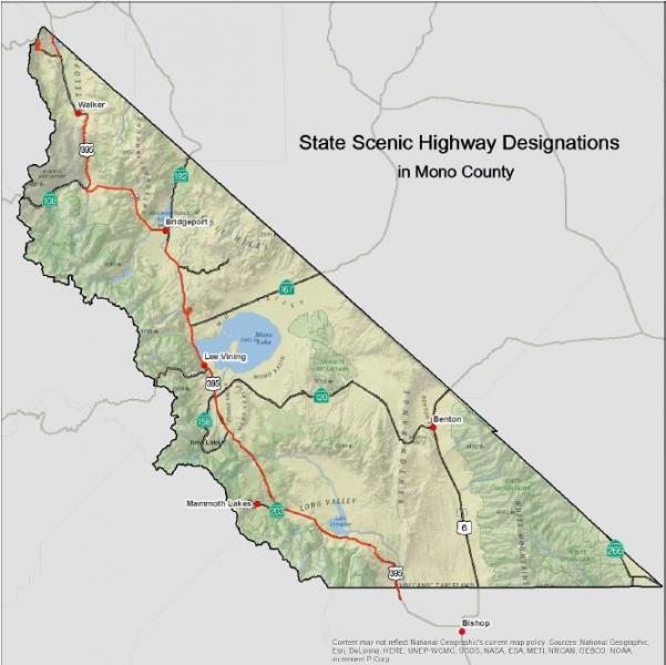
FIGURE 6: Designated County Scenic Highways
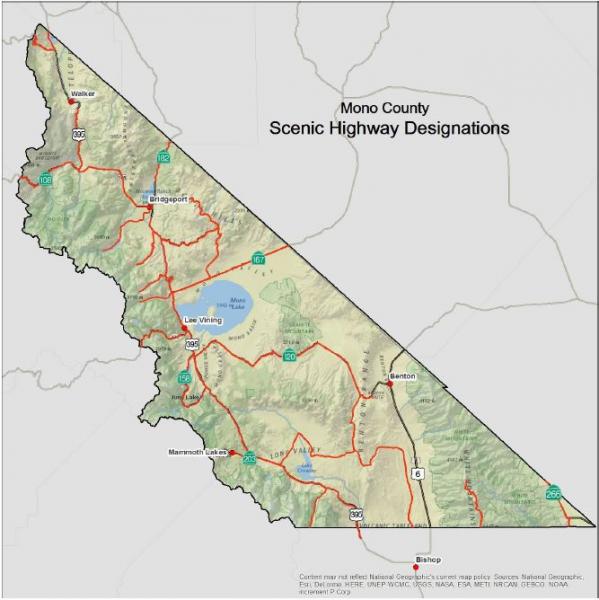
Town of Mammoth Lakes Transportation System
Road SystemThe major access into the town of Mammoth Lakes is provided by SR 203, which intersects with US 395, just east of the town limits. SR 203 (also named Main Street) is a four-lane road from US 395 through the majority of the developed portion of the town. SR 203 returns to two lanes north of the intersection of Main Street and Minaret Road. The highway continues from the developed area of the town to the Mammoth Mountain Ski Area, and terminates at the Mono-Madera county line. Portions of SR 203 are augmented by frontage roads. According to Caltrans' classification system, SR 203 is a minor arterial for the first 8.3 miles from US 395 through the town, and a minor collector for the westernmost 0.7 miles. Mammoth Scenic Loop, a two-lane road off SR 203, provides secondary access from the town to US 395 to the north. The Town's Road Network is shown in Figure 7.
ParkingParking in Mammoth Lakes is largely provided in private lots. In addition to the substantial parking lots provided at ski access portals, significant private parking facilities are provided at commercial centers. There is one park-and-ride lot located on the corner of Tavern and Old Mammoth; this lot is free, located adjacent to a transit stop, and can accommodate up to 100 cars. Existing parking lots in the town are well utilized during periods of peak visitor activity. The public has noted that traffic congestion in and around the town is caused in part by a shortage of accessible private and public parking. Mammoth Lakes is completing a Parking Study to evaluate existing conditions and estimate future demand. The study contains recommendations for parking control measures for the commercial portions of the town, including park-and-ride lots.
TransitThere are currently several public and private transit operations serving the Town:
Interregional Transit
The Eastern Sierra Transit Authority (ESTA) provides regional and long-distance service along US 395 from locations in the county to Lancaster and Reno. The southern portion of the route provides connections from Lancaster to Los Angeles and Kern counties, Metrolink, Amtrak, Greyhound and the Inyokern Airport. The northern portion of the route provides access to the Yosemite Area Regional Transportation System (YARTS), Reno-Tahoe International Airport, Amtrak, and Greyhound.
Mammoth Express
ESTA operates three round trips per day between Bishop and Mammoth, five days a week, with stops at Tom’s Place and Crowley Lake. This route is intended to serve commuters.
Mammoth Fixed Routes
ESTA now operates the year-round fixed route services in the town of Mammoth Lakes, and all winter routes previously operated by MMSA. MMSA contracts with ESTA to provide service to all winter ski portals, including capital replacement costs.
Dial-A-Ride (DAR) Services
ESTA provides DAR services in Mammoth. ADA paratransit services are available in Mammoth when DAR services are not available.
Reds Meadow Shuttle
ESTA contracts with the USFS to operate a shuttle from Mammoth Lakes to Reds Meadow and Devils Postpile during the summer months.
Mammoth Mountain - June Mountain Ski Area Winter Shuttle
ESTA operates a daily winter shuttle between Mammoth and June Lake, with two round trips per day.
Vanpool
ESTA has offered a vanpool program for commuters between Bishop and Mammoth, but it was suspended due to low ridership.
Yosemite Area Regional Transportation System (YARTS)
During the summer, YARTS provides service to and from Mammoth Lakes in Mono County (and locations in Mariposa and Merced counties) on a schedule that connects with the Yosemite National Park free shuttle service.
Lodging-based Shuttles
Condominiums and hotels in Mammoth Lakes and June Lake provide this service. These shuttles provide on-demand service to the Mammoth Yosemite Airport and to the ski areas for lodging guests.
Taxi Service
Limited taxi services are offered in Mammoth Lakes on a metered, demand-responsive basis.
Non-Motorized FacilitiesBiking, including organized bike races, has become an increasingly popular activity in and around the town. The General Bikeway Plan, updated in February 2014, provides a comprehensive plan for bicycle facilities, focusing on direct and convenient routing for the commuting cyclist. Figures 7A and 7B show existing and proposed bike paths in the town.
The Town of Mammoth Lakes Trail System Master Plan (MLTSMP) adopted in 2011 focuses on non-motorized facilities for alternative forms of transportation, including pedestrians, bicyclists, and Nordic skiers. The MLTSMP would connect and pass through a series of parks and open-space areas, having numerous access points in and around the town. Because of the significant existing and future traffic congestion in the town and the relatively compact development pattern, non-motorized facilities can be more than recreational facilities. A comprehensive trail system for pedestrian, cycling, and Nordic skiing will reduce auto travel, as well as provide important recreational amenities for visitors and community residents. Experience in similar resort communities has indicated a direct economic benefit from expansion of the trail system. Mammoth has already developed over several miles of multi-use paths, 80% of which have been funded with state and federal grant money.
In an effort to further develop an extensive pedestrian system, the Town adopted a comprehensive Pedestrian Master Plan in February 2014 (see Figures 7C and 7D).
AviationThe Mammoth Yosemite Airport is an important attribute to the community. Located eight miles east of the town, the airport is an FAA-certified commercial airport, currently offering charter services. The Mammoth Yosemite Airport is owned and operated by the Town of Mammoth Lakes. Scheduled commercial air service is currently available to northern and southern California (San Francisco, Los Angeles, San Diego) and Denver, CO, with routes varying seasonally.
The Mammoth Yosemite Airport provides an important link in the statewide aeronautics system. Pilots flying the Owens Valley-Long Valley corridor along the Eastern Sierra front find the airport to be a vital means of avoiding rapidly shifting weather conditions. The airport is subject to the Federal Aviation Regulations (FAR) Part 139, which sets standards for the operation and safety of airports with small commercial carriers. Under FAR Part 139, the Mammoth Yosemite Airport is required to have established procedure manuals, as well as crash, fire, and rescue equipment.
Additionally, there are helipads located around the town that are operated by the USFS and BLM (primarily for firefighting purposes), as well as a helipad at Mammoth Hospital that is used for air ambulance services.
The Town of Mammoth Lakes is currently updating the layout plan for the Mammoth Yosemite Airport; approval is expected from the FAA shortly. This plan provides for major development and expansion of the airport terminal area, including major infrastructure improvements, aircraft support facilities, and passenger terminal. The Mono County Airport Land Use Commission adopted a Comprehensive Land Use Plan (CLUP) for the Mammoth Yosemite Airport in 1998. The CLUP establishes specific land use policies to protect the public welfare and the safety of aircraft operations.
FIGURE 7: Town of Mammoth Lakes – Road Network
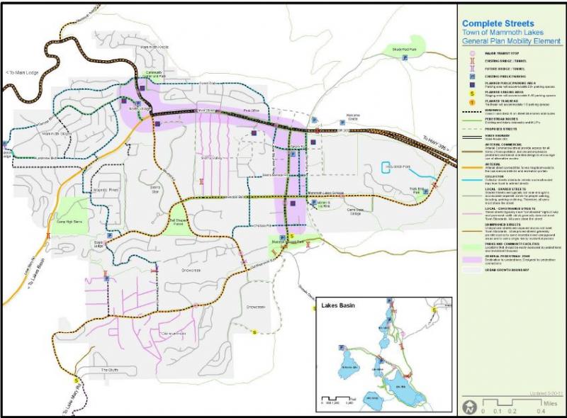
FIGURE 7A: Town of Mammoth Lakes – Bicycle Network
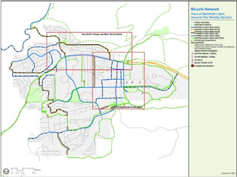
FIGURE 7B: Town of Mammoth lakes – Bicycle Network Detail
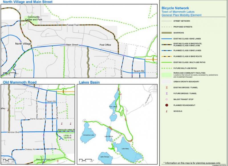
FIGURE 7C: Town of Mammoth Lakes – Pedestrian Network
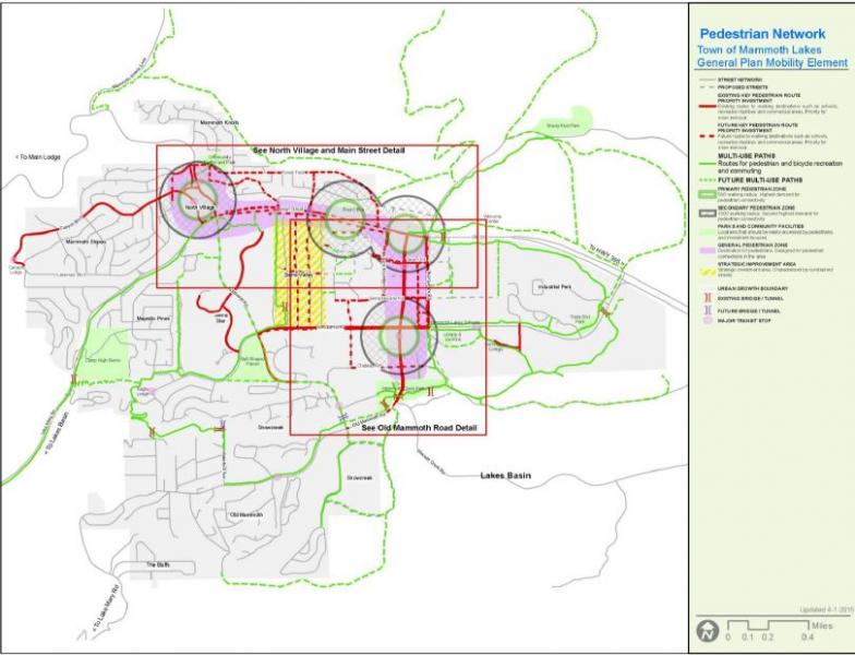
FIGURE 7D: Town of Mammoth Lakes – Pedestrian Network Detail
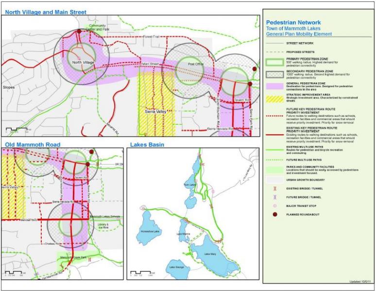
- SR 203 (Main Street) experiences significant traffic congestion in Mammoth Lakes and between the town and Mammoth Mountain Ski Area during the winter months. This traffic congestion adversely impacts air quality due to auto emissions, diesel fumes from buses, and re-suspended road dust and cinders. Traffic congestion is also of concern during certain periods in the summer, both along arterial streets in the town, as well as between Mammoth Lakes, Reds Meadow and Devils Postpile.
- There continues to be a reliance on the private automobile. Parking availability is inadequate in commercial activity centers during periods of peak visitor activity, which exacerbates traffic congestion and generates illegal on-street parking that may hinder snow removal and internal circulation, as noted by the Town during snow-removal operations.
- The Mammoth Yosemite Airport's ability to offer expanded services (such as commercial scheduled air service) is limited due to inadequate facilities, runways, and aircraft ramps. The lack of infrastructure improvements reduces visitor air access to the region, which in turn maintains dependency on the automobile and perpetuates traffic problems in the community.
- Traffic congestion is expected to increase as a result of improvements to the Mammoth Mountain Ski Area as well as new growth areas/developments, including North Village, Sierra Star, and Snowcreek. Increased traffic, due to these expansions and new developments, will aggravate congestion and increase conflicts between vehicles and pedestrians. However, some of the Town's arterial roadways provide traffic capacity in excess of existing or forecast future needs, unnecessarily increasing their impact on the pedestrian/bicycle environment and the overall visual quality of the community.
Travel Demand, Town of Mammoth Lakes
Existing Travel DemandTravel demands in Mammoth Lakes are defined by resident activity as well as visitor activity. Year-round, the community's permanent population of roughly 7,500 generates travel demand patterns much like any other community of similar size, including employment trips, shopping trips, school trips, and recreational trips. In addition, the community's transportation network is impacted by the travel demand generated by visitors, which add up to roughly an additional 32,500 persons to the overnight population during the winter ski season. A summary of factors impacting existing travel demand is presented in Table 8.
Existing traffic volumes are depicted in the North Village Specific Plan Existing Plus Project Travel Impact Analysis (LSA Associates, Inc., Revised June 22, 2000). As shown, the highest traffic volumes in the community are found on Main Street between Minaret Road and Old Mammoth Road, with 15,900 to 16,400 vehicles per typical winter Saturday. The second-busiest street is Old Mammoth Road between Chateau Road and Main Street with 9,400 to 11,500 vehicles per typical winter Saturday. Traffic volumes on all other roadways are f than 10,000 vehicles per day.
TABLE 8: Factors Affecting Travel Demand in Mammoth Lakes
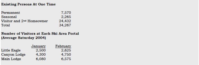
Existing traffic volumes are depicted in the Mammoth Lakes Transportation 2004, and 2024 [build-out year of the General Plan] Traffic Volume Results (LSC Transportation Consultants, December 7, 2004). As shown, the highest traffic volumes in the community are found on Main Street between Minaret Road and Old Mammoth Road, with 1,600 to 1,700 vehicles per hour on a typical winter Saturday. The second busiest street is Old Mammoth Road between Chateau Road and Main Street, with 1,250 to 960 vehicles per hour on a typical winter Saturday. Finally, the traffic volume along Minaret Road immediately north of Main Street is currently 1,090 vehicles per hour on a typical winter Saturday. Traffic volumes on all other roadways are less than 1,000 vehicles per hour.
Review of existing traffic conditions yields the following findings:
- Traffic activity varies substantially with season. Caltrans’ counts from the 2003-04 count season indicate that the average daily traffic on Main Street just east of Minaret Road in the peak summer month (August) of 12,688 vehicles per day slightly exceeds the peak winter month (February) volume of 12,617 vehicles per day. In comparison, the lowest monthly volume of 8,553 occurs in May and corresponds to only 67% of the traffic volume in the peak month.
- However, the average Saturday traffic volume along Main Street just east of Minaret Road in January and February was equal to 15,565 and 15,970 vehicles per day, respectively. These average winter Saturday traffic volumes are higher than the average daily traffic volumes occurring on any day throughout the week in the summer. This suggests that although overall traffic volumes are consistently higher during the summer months, winter Saturdays represent the period during which the highest traffic volumes occur.
- Reflecting historic patterns of ski area facilities and amenities, a substantial proportion of existing access to MMSA is provided via Minaret Road. This concentration of ski traffic (particularly at the end of the ski day) on a two-lane facility, with limited capacity, creates the town’s most significant recurring traffic congestion problem.
- On a peak winter day, the Mammoth Mountain Ski Area transit ridership equals approximately 14,200 passengers. This equates to approximately 6,400 skiers, assuming each skier makes one transit round trip per day and that 90% of the passengers are skiers. In addition, according to Mammoth Mountain Ski Area, during the 2003-04 ski season approximately 21,600 skiers visited the ski area on the peak day. Therefore, it is estimated that approximately 30% of the skiers access Mammoth Mountain Ski Area by public transit.
In addition to general growth in travel resulting from increases in population and visitation, travel demand in Mammoth Lakes will be impacted by the following planned development:
- Implementation of the North Village Specific Plan;
- Completion of development at Snowcreek;
- The Sierra Star project;
- Shady Rest; and
- The Airport Facility and Service Expansion project.
A number of smaller residential and lodging projects will also increase travel demand. As part of the North Village and Sierra Star projects, access to MMSA will be substantially modified, increasing the proportion of access that is provided by portals other than Main Lodge.
The traffic model update analyses, prepared by LSC, indicate that total peak winter Saturday person trips will increase from the current level of approximately 166,000 to approximately 295,000 at build-out of the General Plan. Considering shifts in travel mode, average winter day traffic volumes on Town roadways will generally increase as follows:
- Main Street between Minaret Road and Old Mammoth Road: 24% to 55% increase;
- Lake Mary Road between Canyon Boulevard and Kelley Road: 42% to 98% increase;
- Old Mammoth Road between Main Street and Meridian Boulevard: 22% to 41% increase;
- Minaret Road between Main Street and Meridian Boulevard: 91% to 202% increase;
- Minaret Road between Main Street and Forest Trail: 44% to 61% increase;
- Minaret Road immediately north of Forest Trail: 71% increase; and
- Meridian Boulevard between Old Mammoth Road and Minaret Road: 45% to 129% increase.
Transit
Existing Transit ServicesThe Eastern Sierra Transit Authority (ESTA) was formed through a Joint Powers Agreement (JPA) in October 2006 to replace Inyo-Mono Transit as the transit provider in the Eastern Sierra. Its members are Mono County, Inyo County, the Town of Mammoth Lakes, and the City of Bishop. As a transit operator, ESTA provides a variety of local and regional transit services, including demand-response, fixed-route, deviated fixed route, intercity connections to multiple communities in the Eastern Sierra, and regional service to Reno, NV, and Lancaster, CA.
ESTA provides transit services in Mono County and regionally. ESTA recently adopted the Inyo-Mono Counties Coordinated Public Transit-Human Services Transportation Plan Update (April 4, 2014). This document provides extensive information on existing transit services in the region, a transportation needs assessment for the region, and an implementation plan for providing coordinated services throughout the region. That plan is incorporated by reference in the RTP.
The following transit services are currently available in Mono County:
ESTA TRANSIT SERVICES
Interregional Transit
ESTA provides regional and long-distance service along US 395 from locations in the county to Lancaster and Reno. The southern portion of the route provides connections from Lancaster to Los Angeles and Kern counties, Metrolink, Amtrak, Greyhound and the Inyokern Airport. The northern portion of the route provides access to the Yosemite Area Regional Transportation System (YARTS), Reno-Tahoe International Airport, Amtrak and Greyhound.
Mammoth Express
ESTA operates three round trips per day between Bishop and Mammoth, five days a week, with stops at Tom’s Place and Crowley Lake. This route is intended to serve commuters.
Mammoth Fixed Routes
ESTA now operates the year-round fixed-route services in the town of Mammoth Lakes, and all winter routes previously operated by MMSA. MMSA contracts with ESTA to provide service to all winter ski portals, including capital replacement costs.
Dial-A-Ride (DAR) Services
DAR services are provided in Walker and Mammoth. ADA paratransit services are available in Mammoth when DAR services are not available.
Reds Meadow Shuttle
ESTA contracts with the USFS to operate a shuttle from Mammoth Lakes to Reds Meadow and Devils Postpile during the summer months.
Mammoth Mountain - June Mountain Ski Area Winter Shuttle
ESTA operates a daily winter shuttle between Mammoth Lakes and June Lake.
Vanpool
ESTA has offered a vanpool program for commuters between Bishop and Mammoth Lakes, but it was suspended due to low ridership.
OTHER TRANSPORTATION SERVICES
Yosemite Area Regional Transportation System (YARTS)
During the summer, YARTS provides service to and from Mammoth Lakes, June Lake and Lee Vining in Mono County (and locations in Mariposa and Merced counties) to Yosemite Valley, and more recently to Tuolumne Meadows as a high-country alternative to relieve congestion in Yosemite Valley, on a schedule that connects with the Yosemite National Park free shuttle service.
Lodging-based Shuttles
Condominiums and hotels in Mammoth Lakes and June Lake provide this service. These shuttles provide on-demand service to the Mammoth Yosemite Airport and to the ski areas for lodging guests.
Taxi Service
Limited taxi services are offered in Mammoth Lakes on a metered, demand-responsive basis.
Mono County Senior Services
Mono County Social Services runs the Senior Services program, and provides transportation services for seniors who cannot ride ESTA buses due to physical limitations. The agency takes seniors shopping, to the doctor, or to obtain other services, locally or long distance. Senior trips go to destinations such as AARP conventions, Reno, or Los Angeles. Senior Services runs a meals-on-wheels program and helps distribute government surplus food throughout the county.
Inyo-Mono Association for the Handicapped (IMAH)
IMAH provides respite care and adult day-care services for older adults and developmentally disabled residents. IMAH provides transportation for clients to and from programs as well as to work, using six vehicles it owns.
Toiyabe Indian Health Project
The Toiyabe Indian Health Project provides transportation for Native Americans and their families for shopping, medical and other necessary purposes. Based in Bishop, the project provides transportation in both Inyo and Mono counties.
School Buses
The county's dispersed population and the location of its public schools require some students to travel many miles to and from school. Both the Eastern Sierra Unified School District and the Mammoth Unified School District provide bus services for their students.
Charter Services
There are no other interregional transit services other than private charter lines. The majority of private charters originate in Southern California and less frequently from the Bay Area and Las Vegas. The majority of charter buses stop in Mammoth Lakes. According to the Mammoth Lakes Visitors Bureau, approximately 20 to 30 buses per day serve Mammoth Lakes in the summer months, averaging approximately 40 persons per bus, and approximately 10 to 15 buses arrive per day in the winter months, averaging 40 persons per bus.
Transit Dependent PopulationsTransit needs may be assessed in terms of those segments of the population that are dependent on some form of public transportation. In Mono County, these are generally young people, seniors, disabled persons, or low-income persons. Table 9 shows population projections for young people and seniors. The percentage of young people is projected to remain relatively stable over the next 20 years while the senior population is projected to rise approximately 100% over the next 20 years. The senior population often has mobility concerns that require specialized transportation.
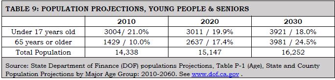
The current Inyo-Mono Counties Coordinated Public Transit-Human Services Transportation Plan (2014) prepared for ESTA notes the following concerning transit-dependent populations in Mono County:
- The greatest number of persons over age 65 in Mono County lives in Mammoth Lakes (550);
- Mammoth also has the greatest number of persons living below the poverty level (1,058), as well as a high number of seasonal workers;
- There are 75 households without a vehicle in Mammoth and 53 in June Lake;
- Data on residents with disabilities is not yet available from the 2010 Census;
- Most employment in Mono County is within the tourism sector related to the ski resort, or to county government. Major employers in Mono County (more than 200 employees) include Mammoth Hospital, Mammoth Mountain Ski Area, and Mono County.
- In Mono County, the median household income is $60,469. Around 2.4% of households receive Supplemental Social Security, 1.2% received cash assistance, and 4.3% receive SNAP benefits;
- Nearly 40% of Mono County employed residents work in Mammoth Lakes. Another 11.3 work in Crowley Lake. Approximately 7% commute to Bishop and another 5.3% commute to Bridgeport. Almost 75% of employees working in Mammoth Lakes commute from elsewhere, largely Bishop, Crowley Lake, Chalfant and June Lake. There is a high level of commuting between Bishop and Mammoth Lakes, with a greater number of commuters traveling from Bishop to Mammoth Lakes.
- Population projections prepared by the California State Department of Finance forecast a very significant growth in older adults who will require access to medical and social services. The senior population (65+) is forecast to increase by 30% between 2010 and 2020, and by 20% between 2020 and 2030. Between 2020 and 2030, much of the increase will be in residents age 75+.
Transit issues and needs include the following:
- The Eastern Sierra Transit Authority Short-Range Transit Plan is incorporated as part of the Mono County RTP (see Chapter I, Planning Process). That plan provides greater detail concerning transit needs, facilities, and services in Mono County. The Mammoth Lakes Transit Plan is also incorporated as part of the Mono County RTP and provides greater detail concerning transit needs, facilities, and services in Mammoth Lakes.
- The Inyo-Mono Counties Coordinated Public Transit-Human Services Transportation Plan Update is incorporated by reference and provides great detail about transit needs, facilities, and services in Mono County and the Eastern Sierra. That plan identifies a number of issues and opportunities for the continuing provision of transit services in the Eastern Sierra, including:
- Coordination of existing services;
- Opportunities to increase coordination among service providers;
- Barriers to coordination (geographical, staffing, cost of fares, restrictions on the use of certain small vehicles owned and operated by social-services agencies, lack of funding);
- Opportunities to eliminate duplication of services, thereby maximizing limited transportation resources; and
- Opportunities to plug gaps in service identified by human service agencies in the area.
- The current principal method of transportation to and through Mono County is the highway system. Alternative methods of moving people and goods to and through the county are limited. There is no rail service. The existing airports, because of their high-altitude location and the often severe weather conditions in the area, are limited in the amount and type of service that they can accommodate.
- There is a continuing need for increased transit services to reduce congestion and related air quality impacts, particularly in Mammoth Lakes and potentially in June Lake.
- Transit-dependent populations in Mono County include young people, seniors, and low-income persons. Over the next 20 years, the population of young people is projected to remain relatively stable while the senior population is projected to increase significantly. Estimates show the number of persons living in poverty to be relatively stable. Although low-income persons traditionally are transit dependent, social-services providers indicate that they tend to be less so in Mono County where the need for a car is greater than in more urbanized areas.
- There are a significant number of commuters in Mono County, particularly between Mammoth Lakes and Bishop.
- The June Lake and the Bodie Hills area policies both encourage the development of transit shuttle services in their respective areas.
Non-Motorized Facilities
Non-motorized issues and needs include the following:
- The County completed a Trails Plan, including a General Bikeway Plan, in 1994 and updated both plans in 2015 (see Appendix G for the Trails Plan). These plans provide comprehensive planning for non-motorized facilities in the unincorporated areas.
- The overall purpose of the Mono County Trails Plan is to establish trail systems that facilitate multi-modal travel and recreation within, around and between unincorporated communities in the county. The plan addresses regional routes that provide access to communities throughout the county and to major recreational areas and existing trail systems, and community routes that provide access throughout communities and to surrounding recreational areas.
- The Trails Plan is intended to expand upon and implement policies in the Mono County General Plan, associated Area Plans, and the RTP, and to coordinate with the applicable plans of Federal land management agencies. The Plan focuses primarily on the development of facilities for recreational users, both residents and visitors, and conceptualizes the opportunity to create an Eastern Sierra Regional Trail system. This proposed system would provide a regional non-wilderness trail system close to 300 miles long in Inyo and Mono counties. Ninety percent of the system would be on existing trails, old railroad alignments, wagon roads, and abandoned roads; 10% of the system would require new construction. This project has been developed to a conceptual level and requires further development, including community and agency outreach to refine alignments, projects and programs.
- The Mammoth Lakes General Bikeway Plan (2014), Mammoth Lakes Pedestrian Master Plan (2014), Mammoth Lakes Trail System Master Plan (2011), and the Municipal Wayfinding Master Plan (2012) are incorporated as part of the Mono County RTP. Those documents provide comprehensive planning for non-motorized facilities in the town of Mammoth Lakes.
- There is a growing need for additional trail systems throughout the county, both within and between community areas. There is the potential to link existing trail systems, which are predominantly on public lands, to newly developed trail systems on private and county lands in community areas. State planning law (Section 65302 (e) et seq. of the Government Code) requires every city and county to consider a trail system in its open space element. The law also requires every city and county to consider the feasibility of integrating its trail system with appropriate segments of the state system.
- Most bicycle travel in the region now occurs on streets and highways without special bike facilities. This will probably be true in the future as well, particularly as commuting by bicycle increases in popularity in community areas. In some instances, some street systems may be fully adequate for safe and efficient bicycle travel, and signing and striping for bicycle use may be unnecessary. In other cases, signing and/or striping can serve as a means to alert motorists of the presence of bicyclists that may be using the roadway.
- In past RTPs and Circulation Elements, the Mono County LTC adopted the policy that the most important effort that could be undertaken to enhance bicycle travel would be improved maintenance of existing roads that are used regularly by bicyclists. This effort requires increased attention to the shoulder portion of roadways where bicyclists are expected to ride. Caltrans has indicated that it has put increased sweeping into its maintenance budget and has received good feedback.
- The consideration of bicycle needs in construction projects and in safety and operational improvements is also important. Through the Mono County Trails Plan the County road system has been reviewed to determine the immediate needs of bicyclists in terms of increasing safety for riders and requests by users for bicycle lanes. Many rural highways are used by touring bicyclists and locals for recreational travel and travel between communities. The development and maintenance of paved roadway shoulders with a wider 8-10 inch edge-line stripe would significantly improve the safety and capacity for bicyclists.
- In January 2000, the Mono County LTC voted to support the following requests from the Sierra Cycling Foundation for bike route signing in Mono County on state highways and county routes:
- US 395 north and south from Tom’s Place to SR 158;
- June Lake Loop (SR 158) in both directions;
- SR 120 to Benton in both directions;
- US 395 north of June Lake Junction to Lee Vining in both directions;
- SR 203 from US 395 to Mammoth Mountain Ski Area in both directions;
- Upper Rock Creek Road from Tom’s Place to Mosquito Flat in both directions;
- Lower Rock Creek Road from Tom’s Place to the Inyo County line in both directions;
- Benton Crossing Road to SR 120 in both directions;
- Crowley Lake Drive to Sherwin Creek Road in both directions; and
- Owens River Road in both directions.
- With the exception of Upper Rock Creek Road, all routes have been identified in the RTP and Mono County General Plan Circulation Element as Regional Bike Routes. Caltrans wants to ensure that bike route signage on state highways is coordinated with bike route signage on other county routes. They intend to install signs as soon as they verify that routes proposed for bike route signage are appropriate for bicycle usage.
- There is a need for improved and expanded pedestrian facilities in community areas throughout the county, both to improve safety and to increase access to commercial core areas in communities. Safe Routes to Schools routes can be developed in additional areas. The community issues section of this document identifies those areas where improved pedestrian facilities are needed, such as the June Lake Village. The Livable Communities planning process is developing planning principles, included in this RTP, to convert communities in the county to more walkable communities. The focus is on Crowley Lake, Lee Vining, June Lake, and Bridgeport.
- Active Transportation Program funding provides an opportunity to develop and fund coordinated systems for non-motorized users. There may be an opportunity to target some of the lower-income areas of communities, if they qualify as disadvantaged communities.
The unincorporated area of Mono County, outside of the town of Mammoth Lakes, has few existing dedicated bicycle facilities. The following section on bicycle needs in the unincorporated area of Mono County is an excerpt from the Mono County Bicycle Transportation Plan (Draft, 2014):
Existing Bicycle Routes and SignageAlthough cycling is an increasingly popular activity in Mono County, the County lacks facilities specifically for bicyclists. Most cycling occurs on roadways where the shoulder may or may not be wide enough to accommodate bicyclists safely. Mountain bike use occurs throughout the county on dirt roads, which generally are not marked as bike trails. The following are the sections of local roads with markings/signage for bike use:
- Bike Route along Crowley Lake Drive and South Landing Road from Tom’s Place to Crowley Lake;
- Bike Route along Pearson Road in Crowley Lake;
- North Shore Drive Bike Route in June Lake;
- Share the Road signs along Benton Crossing Road;
- Share the Road signs along SR 158 in June Lake;
- Bicycle/pedestrian bridge over the East Walker River in Bridgeport;
- Recently designated bike lane on Main Street (US 395) in Bridgeport; and
- Eastside Lane Bike Route in the Antelope Valley
It is the policy of the Local Transportation Commission that when rehabilitation work is planned for local/state highways, that non-motorized users be consulted for the addition of bike/pedestrian facilities prior to construction.
Existing Rest FacilitiesRest facilities (e.g., restrooms, drinking water, public phones, and air for tires) and parking facilities (for vehicles and bicycles) are available in most communities at the community center, private facilities in communities, schools, county parks, and USFS facilities. Caltrans maintains the Crestview Safety roadside Rest Area (US 395).
Outside of communities, rest facilities and parking facilities are available at USFS facilities (campgrounds and recreational areas), and at private recreational areas (e.g., Twin Lakes, Brown's Campground on Benton Crossing Road, etc.). There are few rest facilities on the many dirt roads in the county used by bicyclists. Most of those roads are on public lands and the applicable land management policy for those areas is generally to keep them as undeveloped recreational areas.
The Eastern Sierra Scenic Byway provides interpretive kiosks and some rest facilities along the length of US 395 in Mono County and along SR 120 between Yosemite National Park and US 395.
Existing Parking Facilities
Bike racks are located at the following locations:
- June Lake Library and Community Center;
- USFS Mono Basin Visitor Center in Lee Vining;
- Behind Mono Mart in LV for employees;
- County Annex building in BP;
- Lee Vining High School;
- Lee Vining Community Center; and
- Town of Mammoth Lakes in various locations
No facilities specifically exist for bicycle riders to change clothing (changing facilities) except for restrooms adjacent to the bike racks mentioned above.
Transport Facilities/Public Transit ConnectionsAll Eastern Sierra Transit buses have bike racks. The transit system recently installed shelters in various communities throughout the county; however, the shelters will not be equipped with bike racks.
Bus shelters have been installed at the following locations:
- Crowley Lake Drive, just north of Tom’s Place store;
- Community Center in Crowley Lake;
- Benton, US 6 in front of the school;
- Lee Vining, near the Mono Vista RV park and in front of the Caltrans Yard and on SR 120 at the Mobil Mart YARTS stop;
- Mono City, on US 395;
- Walker, US 395 southbound at Mule Deer Road and northbound across from Mule Deer Road;
- Coleville, US 395 southbound just south of the school;
- Bridgeport, on Emigrant Street next to the County Park tennis courts; and
- Town of Mammoth Lakes along Main Street and Meridian Boulevard
The unincorporated area of Mono County, outside the town of Mammoth Lakes, has few existing dedicated bicycle facilities. With job centers and school locations often outside their community, it is not practical for most people to commute to work on bicycles or for many students to commute to school using bicycles. Both students and workers must often drive many miles to their destination, to a community other than the one in which they reside. Extreme weather conditions also make it difficult to bike year round; snow and ice in many parts of the county limit winter biking opportunities, while extreme heat and dust storms decrease summer biking opportunities in a few other areas.
There is growing interest in commuting by bicycle within communities. Generally, traffic congestion is limited, and air quality impacts from automobile use are minimal in the county. Most Mono County communities are small, with relatively flat topography.
The 2009-13 American Community Survey indicated 2.5% of workers ride bicycles to work, and 14% walk.
Recreational Use/Bicycling EventsRecreational biking is an increasing tourist attraction in the county, both on county roads and highways and on unpaved roads on public lands. Opportunities for recreational bicycling are abundant. Many of the County’s paved roads have little traffic and lead to a variety of scenic recreational destinations. The local cycling community currently produces several large-scale bike events on roads within the county (the High Sierra Fall Century/Gran Fondo, Everest Challenge, Pamper Pedal, and several others). The Sierra Cycling Foundation/Eastside Velo has indicated that organizers would like to attract more large-scale biking events to the county.
Safety and Education ProgramsSeveral entities within Mono County conduct bicycle safety and educational programs.
- The Mono County Health Department sponsors bicycle safety activities throughout the year in conjunction with other County and Town agencies. A limited number of bicycle helmets are available for children whose families cannot afford to buy one.
- The Mammoth Lakes Police Department has an ongoing program of bicycle safety and education primarily oriented toward elementary school-aged children. The program includes a yearly “Bicycle Rodeo” for all grades, bicycle inspection, bicycle safety handouts, and bicycle registration. The Bicycle Rodeo focuses on riding safety and instruction, helmet use, traffic-sign recognition, bicycle lane use, handling crosswalks, hand signals, etc. Bicycles are checked for safety features such as seats, handlebars, brakes, and tires; a special sticker is issued validating inspection. The program is conducted on a yearly basis. Safety handouts are also available for younger children in the first and second grades.
- Sierra Cycling Foundation’s mission is to promote cycling and improve cycling conditions in the Eastern Sierra. The group advocates bicycle safety and education of cyclists as well as motor-vehicle operators, strongly supports the “share the road” concept, and continually strives to add more miles of “share the road” signs. Eastside Velo provides bicycle safety information and suggested routes and rides for cyclists visiting and living in the Eastern Sierra and emphasizes bicycle-safety training for children, mandatory helmet laws, and safer road conditions by working with public works and planning departments in Inyo and Mono counties, the Town of Mammoth Lakes, the City of Bishop, Eastside Velo and Caltrans, District 9.
The Caltrans Highway Design Manual identifies four types of bicycle facilities:
- Shared Roadway (No bikeway designation).
- Class I Bikeway (Bike path). Separate right of way for bicyclists. Generally should serve corridors not served by streets or highways.
- Class II Bikeway (Bike lane). Utilizes the shoulder area of roads. Signing and striping separate areas for bicyclists and motorists.
- Class III Bikeway (Bike route). Similar to a Class II Bikeway, except that the shoulder area is shared with vehicles.
Most of the facilities in the county are Shared Roadways. There is a short Class II Bikeway along Crowley Lake Drive in the vicinity of Aspen Springs as well as in downtown Bridgeport. There are also marked mountain bike routes on dirt roads in the western end of Long Valley. Caltrans District 9 generally pursues 8-foot shoulders on highways when feasible for safety, which also facilitiates bike use, and has initiated a District 9 multi-modal plan to provide additional direction for District 9 facilities.
Selection of the appropriate type of bikeway to meet an identified need is dependent on many factors, including safety, demand, and connection to other bike facilities. The Caltrans Highway Design Manual contains criteria to help determine whether designation of a bikeway is appropriate and, if so, which type is most suitable. The relative cost of various types of facilities is also a consideration.
In Mono County, shared roadways (with a 4-foot paved shoulder and 8- to 10-inch edge stripe) will continue to be the most feasible type of bikeway in most areas. Relatively low bicycle demand may make it infeasible to designate bikeways; environmental considerations and maintenance costs may make it difficult to develop separate bike paths.
The Bicycle Transportation Plan contains a list of overall needs related to biking in unincorporated Mono County, which was developed by local bicycling groups, along with lists of specific needs for community areas.
Town of Mammoth Lakes – Non-Motorized FacilitiesIn Mammoth Lakes, non-motorized facilities for the use of pedestrians, bicyclists, equestrians and Nordic skiers have been comprehensively planned. Because of the significant existing and future traffic congestion in Mammoth Lakes, non-motorized facilities can be more than recreational facilities. A comprehensive system of walking, bicycle and Nordic trails will reduce auto travel and provide important visual and activity amenities for visitors and community residents. The Town continues to implement its plans for non-motorized facilities by improving and linking additional portions of its trails system.
Active Transportation ProgramThe Active Transportation Program (ATP) was created by Senate Bill 99 (Chapter 359, Statutes 2013) and Assembly Bill 101 (Chapter 354, Statutes 2013) to encourage increased use of active transportation modes, such as biking and walking. The goals of the Active Transportation Program are to:
- Increase the proportion of trips accomplished by biking and walking;
- Increase the safety and mobility of non-motorized users;
- Advance the active transportation efforts of regional agencies to achieve mandated greenhouse gas reduction goals;
- Enhance public health, including reduction of childhood obesity through the use of programs including, but not limited to, projects eligible for Safe Routes to School Program funding;
- Ensure that disadvantaged communities fully share in the benefits of the program; and
- Provide a broad spectrum of projects to benefit many types of active transportation users.
Ten percent of all ATP funding is awarded to small urban and rural areas with populations of 200,000 or less. Twenty-five percent of the funding in this category must benefit disadvantaged communities. Another 50% of all ATP funding is awarded competitively on a statewide basis. Twenty-five percent of the funding in that category must benefit disadvantaged communities as well.
Funding is available for a variety of project types, including infrastructure and non-infrastructure projects, e.g.:
- Development of new bikeways and walkways that improve mobility, access, or safety for non-motorized users;
- Improvements to existing bikeways and walkways, which improve mobility, access, or safety for non-motorized users;
- Elimination of hazardous conditions on existing bikeways and walkways;
- Preventative maintenance of bikeways and walkways with the primary goal of extending the service life of the facility;
- Installation of traffic-control devices to improve the safety of pedestrians and bicyclists;
- Safe Routes to School projects that improve the safety of children walking and bicycling to school;
- Safe routes to transit projects, which will encourage transit by improving biking and walking routes to mass transportation facilities and school bus stops;
- Secure bicycle parking at employment centers, park-and-ride lots, rail and transit stations;
- Bicycle-carrying facilities on public transit;
- Establishment or expansion of a bike-share program;
- Recreational trails and trailheads, park projects that facilitate trail linkages or connectivity to non-motorized corridors, and conversion of abandoned railroad corridors to trails;
- Education programs to increase bicycling and walking, and other non-infrastructure investments that demonstrate effectiveness in increasing active transportation;
- Development and publishing of community walking and biking maps, including school route/travel plans;
- Components of open-streets events directly linked to the promotion of a new infrastructure project; and
- Development of a bike, pedestrian or active transportation plan.
A portion of Active Transportation Program funding must go to Disadvantaged Communities. For a project to contribute toward the Disadvantaged Communities funding requirement, the project must clearly demonstrate a benefit to a community that meets any of the following criteria:
- The median household income is less than 80% of the statewide average based on census tract level data from the American Community Survey;
- An area identified as among the most disadvantaged 10% in the state according to latest versions of the California Communities Environmental Health Screening Tool (CalEnviroScreen) scores; or
- At least 75% of public school students in the project area are eligible to receive free or reduced-price meals under the National School Lunch Program. Applicants using this measure must indicate how the project benefits the school students in the project area or, for projects not directly benefiting school students, explain why this measure is representative of the larger community.
If a project applicant believes a project benefits a disadvantaged community but the project does not meet the criteria identified above, the applicant may submit a quantitative assessment of why the community should be considered disadvantaged. There are currently no communities in Mono County that meet the criteria for qualification as a disadvantaged community. Standardized state data often do not capture Mono County’s small, rural communities well.
Aviation
Three public airports are located in Mono County: Mammoth Yosemite Airport, Lee Vining Airport, and Bryant Field (Bridgeport Airport). In addition to the airports, there are several helipads located throughout the county. The following information on airports in the county is from the California Aviation System Plan (CASP), 2013 Inventory Element.
Mammoth Yosemite AirportMammoth Yosemite Airport, located eight miles east of Mammoth Lakes, is an FAA-certified commercial airport offering charter services. It is owned and operated by the Town of Mammoth Lakes. The airport provides convenient access for recreation, tourism, and charter services, as well as emergency access for medical and firefighting activities. Mammoth Yosemite Airport has 130 hangars and 80 tie-downs. Eight single-engine planes and two multi-engine planes were based there in 2012.
In 2012, the airport reported 8,000 aircraft operations, with 26,196 enplanements and 39,596 total passengers. Of the 8,000 aircraft operations, 129 were air carriers, 1,759 were air taxis, 2,048 were general aviation local flights, 4,029 were general aviation itinerant flights, and 35 were military flights. Total passenger traffic (combined passenger counts reflecting both enplaned and deplaned counts) rose from 53,541 in 2011 to 54,386 in 2012.
The Mammoth Yosemite Airport provides an important link in the statewide aeronautics system. Pilots flying the Owens Valley-Long Valley corridor along the Eastern Sierra front find the airport to be a vital means of avoiding rapidly shifting weather conditions. The airport is subject to the Federal Aviation Regulations (FAR) Part 139, which sets standards for the operation and safety of airports with small commercial carriers. Under FAR Part 139, the Mammoth Yosemite Airport is required to have procedure manuals, as well as crash, fire, and rescue equipment.
Limited year-round commercial air service is available to Southern California, and more direct flights are available in the winter.[1] That service is subsidized by Mono County, the Town of Mammoth Lakes, and Mammoth Mountain Ski Area. The Town of Mammoth Lakes has formed a public/private partnership with Mammoth Mountain Ski Area (MMSA) to develop the airport. The Town is developing the airport, including widening and lengthening the runway and taxiways, airline ramps, a new terminal, and other safety improvements. MMSA is providing a revenue guarantee for commercial airline service into the airport. The short-term capital improvement program for Mammoth Yosemite Airport, including improvements and maintenance projects, is included in Chapter 5, Action Element.
Lee Vining AirportLee Vining Airport, located in Lee Vining, is designated as a "Limited Use-Recreational Access" facility serving the general aviation public. It is owned and operated by Mono County. The airport provides convenient access for recreation and tourism, as well as emergency access for medical activities.
The airport has three hangars and seven tie-downs; currently no aircraft are based there. The airport has a pilot-activated lighting system and a navigational beacon but no aviation fuel is available. The airport is located at an elevation of 6,802 feet. In 2012, the airport reported 2000 aircraft operations; all 2000 were general aviation itinerant flights.
Recent improvements at the airport included replacing the runway with a properly graded one that is 4,940 feet long and 60 feet wide and installing paved overruns at both ends of the runway. Future improvements include a full-length parallel taxiway, lighting enhancements, perimeter fencing and a card access control gate, and an automatic weather observation system. The short-term capital improvement program for Lee Vining Airport, including improvements and maintenance projects, is included in Chapter 5, Action Element.
Bryant Field (Bridgeport)Bryant Field, located in Bridgeport, is designated as a "Community – Recreational Access" facility serving the general aviation public. It is owned and operated by Mono County. The airport provides convenient access for business and tourism, as well as emergency access for medical and firefighting activities.
The airport has no hangars and 18 tie-downs; currently no aircraft are based there. The airport has a pilot-activated lighting system, a navigational beacon, and aviation fuel available. The airport is located at an elevation of 6,468 feet. The existing runway is 4,239 feet long and 60 feet wide. A parallel taxiway serves about 2/3 of the runway length; extension of the taxiway is limited by the proximity of Bridgeport Reservoir. In 2012, the airport reported 500 aircraft operations; 200 were general aviation local flights, 300 were general aviation itinerant flights. On occasion, the Marine Corps Mountain Warfare Training Center requests special permission to use the airport for training exercises.
Relatively recent safety improvements at the airport include lighted runway distance signs, lighted airport signs, Runway End Identifier Lights (REIL) on runway 34, Precision Approach Path Indicators (PAPI) on Runway 34, lighting vault renovations, and an Automatic Weather Observation System (Superawos). The short-term capital improvement program for Bryant Field, including improvements and maintenance projects, is included in Chapter 5, Action Element.
Helipads
In addition to the airports, there are several helipads in the county. One is operated by the U.S. Marine Corps at its Mountain Warfare Training Center at Pickel Meadow. Others are operated by the USFS and BLM, primarily for firefighting purposes. Helipads located at Mammoth Hospital in Mammoth and at Mono Medical Center in Bridgeport are used for air ambulance services.
Airport Planning Documents
Airport Master Plans guide the future growth and development of an airport and identify improvements needed to respond to aviation demand over a 20-year time frame. Master Plans and Airport Layout Plans were last revised for Bryant Field and the Lee Vining Airport in 2006, and for Mammoth Yosemite Airport in 2000.
Comprehensive Land Use Plans (CLUPs) are adopted by the Airport Land Use Commission (ALUC). These plans have two primary purposes: 1) to provide for the orderly growth of each public use airport and the area surrounding the airport within the jurisdiction of the ALUC, and 2) to safeguard the general welfare of the public within the vicinity of the airport. CLUPs were adopted for Bryant Field and the Lee Vining Airport in June 2006, and for the Mammoth Yosemite Airport in October 1998.
Aviation Forecasts and TrendsAircraft activity in Mono County is primarily general aviation activity; i.e., aircraft used for firefighting, emergency services, charter service, business or recreational use. As shown in Tables 10 and 11, general aviation aircraft activity will continue to play an important role in Mono County and the Eastern Sierra region. Aviation services and the existing airport infrastructure are necessary for the movement of people and light cargo, firefighting, and emergency medical purposes. For visitors, the air services provide the only alternate mode of transportation into Mono County (other than driving). For residents, air services permit rapid communication with business, governmental and medical centers throughout other areas of the state and rapid emergency medical transportation when necessary.
Although Mammoth Yosemite Airport is an FAA-certified commercial service airport providing charter service, plans are in the works to develop the facility for regularly scheduled passenger service. Mammoth Yosemite Airport is also the only airport in Mono County that provides air cargo service.
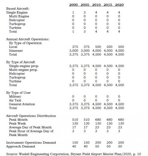
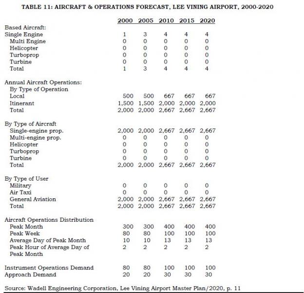
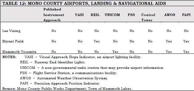
Aviation issues and needs include the following:
- No transportation terminals in the county exist aside from the terminal at the Mammoth Yosemite Airport. Use of that facility is discussed in the Mammoth Yosemite Comprehensive Land Use Plan (CLUP) and the Airport Master Plan. The three airports in the county are important for both residents and visitors. For visitors, the air services provide the only alternate mode of transportation into Mono County. For residents, the air service permits rapid communication with governmental, business, and medical centers in the western part of the state and rapid emergency medical transportation when necessary.
- Land use at all airports in the county is governed by the Airport Land Use Commission (ALUC). The Commission has adopted Comprehensive Land Use Plans (CLUPs) for the airports in the county.
- Expansion of commercial airline service, general aviation operations, and transit connections is considered to be an integral element in alleviating surface transportation problems in the town of Mammoth Lakes. Continued improvement of the Mammoth Yosemite Airport facilities and creation of revenue-generating airport businesses will be necessary before the airport can assume its full role in expanding air transportation services.
- The Town of Mammoth Lakes has formed a public private partnership with Mammoth Mountain Ski Area (MMSA) and Mammoth Lakes Tourism (MLT) to bring commercial air service to the community. The Town operates the airport and provides facilities and equipment that support commercial air service. The Town also seeks funding from the Federal Aviation Administration and other entities to fund capital improvements at the airport. MMSA and MLT secure revenue guarantee contracts with airlines that bring air service to the airport by guaranteeing the airline a minimum return on investment. Without these contracts, air service would not be possible in our area. Currently, the Town is working with the FAA to construct a new terminal building at the airport. A new terminal facility will enhance the ability of the Town and its partners to attract air carriers from a verity of markets. It is expected that the new terminal building and associated ramp and infrastructure will cost approximately $32 million with the FAA picking up approximately 90% of the cost.
- The California Aviation System Plan (CASP) identifies all the airports in the county as ones considered to be the Eastern Sierra’s highest priority facilities in terms of system capacity and safety enhancement. The CASP suggests needed safety improvements at all of the county’s airports.
- Operational and safety improvements are planned at Bryant Field and the Lee Vining Airport; the short-term capital improvement programs for Bryant Field and the Lee Vining Airport include these operational and safety improvements (see Chapter 5, Action Element).
Sustainable Communities Strategy
Metropolitan Planning Organizations (MPOs) are required to incorporate a Sustainable Communities Strategy (SCS) into their RTP in order to provide a process for meeting emissions-reducing goals for each region. The SCS is meant to integrate land use and transportation planning, programs, and projects as a means of reducing greenhouse gas emissions (GHGs). An SCS follows smart-growth planning concepts that seek to integrate development with housing and transportation near jobs, shopping, and schools.
The SCS focuses on the following areas:
- Identifying the general location of uses, residential densities, and building intensities within the region;
- Identifying areas within the region sufficient to house all the population of the region, including all economic segments of the population over the course of the planning period of the regional transportation plan taking into account net migration into the region, population growth, household formation and employment growth;
- Identifying areas within the region sufficient to house an eight-year projection of the regional housing need for the region;
- Identifying a transportation network to service the transportation needs of the region;
- Considering the best practically available scientific information regarding resource areas and farmland in the region;
- Considering the state housing goals;
- Utilizing the most-recent planning assumptions, considering local general plans and other factors;
- Establishing forecasted development patterns for the region, which, when integrated with the transportation network and otachieve, if there is a feasible way to do so, the greenhouse gas emission reduction targets;
- Providing consistency between the development pattern and allocation of housing units within the region; and
- Allowing the regional transportation plan to comply with Section 176 of the federal Clean Air Act.her transportation measures and policies, will reduce the greenhouse gas emissions from automobiles and light trucks to
Mono County, since it is not an MPO, is not required to develop and implement an SCS as part of the RTP. However, the County has taken a proactive stance toward achieving reductions in GHG emissions. Due to the unique physical and land ownership characteristics of land throughout the county, the County has long sought to integrate development within existing communities and to work with the existing transportation system. Mono County and the Town of Mammoth Lakes continue to proactively focus on providing for additional growth within existing communities and on developing a multi-modal transportation system that serves the needs of residents and visitors while at the same time protecting natural resources and reducing greenhouse gas emissions.
The topics to be addressed in an SCS are currently addressed either in the general plans for Mono County and the Town of Mammoth Lakes, or in the Resource Efficiency Plan, discussed previously in this Section. In addition, the County has other plans that support efficient regional development including the draft Mono County Regional Blueprint (Appendix F) and the Eastern Sierra Landownership Adjustment Project. The draft Mono County Regional Blueprint is a collaborative planning process that addresses regional growth management and a coordinated approach to transportation planning. The Blueprint includes a long-range vision, guiding principles, and an implementation strategy that are consistent with the Mono County and Town of Mammoth Lakes general plans and that can be implemented through the general plans. It focuses on providing a “safe, convenient and efficient multi-modal transportation system that enhances regional connectivity and community mobility.”
The Eastern Sierra Landownership Adjustment Project (LAP) notes that “the communities in the Eastern Sierra are uniquely protected from over-development even as they are sometimes constrained from logical and sustainable growth,” due largely to the lack of privately owned land. The Vision Statement of the LAP focuses on providing a regional growth strategy:
“Federal and state agencies, Inyo and Mono counties, local tribes, interested citizens, organizations, and private landowners will collaborate to explore and develop options to create a landownership pattern in the Eastern Sierra that better complements collaborative regional goals while preserving private property rights – focusing on opportunities to concentrate development around existing communities and infrastructure; provide workforce housing; maintain agricultural opportunities; protect water and other natural resources and open space; and consolidate agency lands.”
These planning efforts are directly compatible with the California Transportation Plan (CTP) 2040 update currently under way. The CTP is a statewide, long-range transportation plan to meet our future mobility needs and reduce greenhouse gas (GHG) emissions, and was initiated in conjunction with the California Interregional Blueprint. The CTP’s Vision is based on sustainability:
California's transportation system is safe, sustainable, universally accessible, and globally competitive. It provides reliable and efficient mobility for people, goods, and services, while meeting the State's greenhouse gas emission reduction goals and preserving the unique character of California's communities.
The Vision is supported by six goals:
- Improve multi-modal mobility and accessibility for all people;
- Preserve the multi-modal transportation system;
- Support a vibrant economy;
- Improve public safety and security;
- Foster livable and healthy communities and promote social equity; and
- Practice environmental stewardship.
[1] 2014-2015 flights included San Francisco and San Diego in California; Las Vegas, Nevada; and Denver, Colorado.
[1] See Addressing Climate change Adaptation in Regional Transportation Plans, pages 80-84, http://www.dot.ca.gov/hq/tpp/offices/orip/climate_change/documents/FR3_C.... February 2013.
[2] Original source document: Bodie Hills Multi-modal Plan (date).
[3] Original source document: Mono Basin Multi-modal plan (date).
[4] Original source document: June Lake Multi-modal Plan (date).
[1]Via searches on the American Fact Finder (U.S. Census website) at http://factfinder.census.gov/faces/nav/jsf/pages/index.xhtml and at http://factfinder.census.gov/faces/tableservices/jsf/pages/productview.x...
[2] 2014-2015 Mammoth Lakes PM10 and Meteorological Summary, Great Basin Unified Air Pollution Control District. http://www.townofmammothlakes.ca.gov/DocumentCenter/View/5292, cited May 13, 2015.
Overview
"The purpose of the Policy Element is to address legislative, planning, financial, and institutional issues and requirements, as well as any areas of regional consensus. The Policy Element presents guidance to decision-makers of the implications, impacts, opportunities, and foreclosed options that will result from implementation of the RTP. Moreover, the Policy Element is a resource for providing input and promoting consistency of action among state, regional and local agencies including: transit agencies, congestion management agencies, employment development departments, the California Highway Patrol, private and public groups, tribal governments, etc."
Regional Transportation Plan Guidelines, 2010, p. 93
The Policy Element is required to: 1) describe the transportation issues in the region; 2) identify and quantify regional needs expressed within both short-term (0-10 years) and long-term (10-20 years) planning horizons; and 3) maintain internal consistency with the Financial Element and fund estimates [California Government Code 65080 (b)]. The Policy Element should also describe how policies were developed, identify any significant changes in policies from previous plans, and provide the reasons for those changes.
Transportation issues and regional needs are described in Chapter 2, Needs Assessment. Policies for the Mono County RTP are based on the issues and needs identified in Chapter 2. As described in Chapter 1, Planning Process, the development and updating of the RTP includes ongoing public participation.
The focus of this Policy Element remains the same as in previous RTPs; maintaining existing streets and highways and developing additional transit and non-motorized facilities. The Policy Element should clearly convey the transportation policies of the region. As part of this Element, the discussion should: 1) relay how these policies were developed; 2) identify any significant changes in the policies from the previous plans; and 3) provide the reasons for any changes in policies from previous plans
This section contains regionally oriented transportation policies for Mono County. They are presented in the following format [as required by California Government Code 65080 (b)]:
Goals: End results toward which effort is directed. They are expressed in general terms and are timeless.
Policies: Direction statements that guide future decisions with specific actions.
Objectives: Results to be achieved by an identified point in time. They are capable of being quantified and realistically attained considering probable funding and political constraints. Objectives must be linked to short-range and long-range transportation implementation goals or horizons.
The policies address the following topic areas:
Land Use Issues Transit
Economic Factors Parking
Resource Efficiency Livable Communities
Environmental Issues Aviation
Operational Improvements Plan Consistency
Non-Motorized Transportation Community and Industry Consensus Development
Land Use Issues
GOAL 1. Correlate development of the transportation and circulation system with land use development.
Policy 1.A. Plan and implement a transportation and circulation system that is consistent with the land use, housing, and circulation policies in the Mono County General Plan.
Objective 1.A.1: Evaluate the RTP to ensure consistency with Mono County General Plan policies.
Time frame: Ongoing over the 20-year time frame of this plan; implement every four years with update of RTP.
Objective 1.A.2: Amend these policies as necessary to ensure consistency between the RTP and Mono County General Plan policies.
Time frame: Ongoing over the 20-year time frame of this plan; implement every four years with update of RTP.
Policy 1.B. Plan and implement a transportation and circulation system to provide, but not substantially exceed, the capacities needed to serve the long-range travel demand of residents and visitors.
Objective 1.B.1. Periodically update the long-range regional travel demand by assessing changes in land use, housing and projected demographic changes, conducting travel surveys throughout the county and traffic counts on County roads, and by incorporating data from Caltrans' traffic monitoring system and traffic census program (e.g., Average Daily Traffic (ADT) volumes for state highways).
Time frame: Ongoing over the 20-year time frame of this plan; implement every four years with update of RTP.
Objective 1.B.2. Implement a biennial traffic counting program on County roads.
Time frame: Continue biennial counts over the 20-year time frame of this plan.
Objective 1.B.3. Continue to collaborate with Caltrans in its 10-year origin and destination.
Time frame: Continue every decade.
Policy 1.C. Plan and implement a transportation and circulation system that supports the county Land Use objectives of concentrating development in community areas.
Objective 1.C.1. Accommodate future circulation and transit demand by using existing facilities more efficiently, or improving and expanding them before building new facilities
Objective 1.C.2. As transportation funding and maintenance dollars continues to be flat (or negative), consider providing a larger portion of discretionary funding toward maintaining and fixing current transportation infrastructure (fix it first).
Time frame: Ongoing over the 20-year time frame of this plan; review compliance every four years with update of RTP; review funding with current STIP Transportation Improvement Program cycle.
Policy 1.D. Plan and implement a transportation and circulation system that supports the county Land Use objectives of maintaining and enhancing local economies.
Objective 1.D.1. Avoid highway bypass of communities; instead, work to develop livable communities in those communities where the highway is Main Street while recognizing interregional concerns and functional classification constraints where they exist.
Time frame: Ongoing over the 20-year time frame of this plan.
Policy 1.E. Future land use/development projects with the potential to significantly impact the transportation system shall assess the potential impact(s) prior to project approval. Examples of potential significant impacts include:
- causing an increase in traffic that is substantial in relation to the existing traffic load and capacity of the street system; and/or
- disrupting or dividing the physical arrangement of an established community.
The analysis shall:
- be funded by the applicant;
- be prepared by a qualified person under the direction of Mono County;
- assess the existing traffic and circulation conditions in the general project vicinity;
- describe the traffic generation potential of the proposed project both on site and off site; and
- recommend mitigation measures to avoid or mitigate the identified impacts, both on site and off site.
Mitigation measures and associated monitoring programs shall be included in the project plans and specifications and shall be made a condition of approval for the project. Projects having significant adverse impacts on the transportation system may be approved only if a statement of overriding considerations is made through the EIR process. Traffic impact mitigation measures may include, but are not limited to, off-site operational improvements, transit improvements, or contributions to a transit fund or road improvement fund.
Policy 1.F. Require new development, when determined to be necessary by the Public Works director and found to be consistent with application laws by County Counsel, to provide dedications for improvements such as bicycle and pedestrian paths, transit facilities, snow-storage areas, and rights of way for future public roads identified in the Circulation Element, in conformance with the Subdivision Map Act (Government Code Section 66475 et seq.).
Objective 1.F.1. Amend County Code Section 17.36.100 to conform to Policy 6. Until such time as the County Code is amended, Policy 6 shall supersede Mono County Code Section 17.36.100. The County is amending its Subdivision Ordinance (Chapter 17 of the Mono County Code).
Time frame: Within two years.
Objective 1.F.2. Require new specific plans to contain a detailed plan, including financing arrangements, for local roadway and transit improvements (as applicable).
Time frame: Ongoing over the 20-year time frame of this plan.
Economic Factors
GOAL 2. Plan and implement a transportation and circulation system that is responsive to the County’s economic needs and fiscal constraints and that maintains the economic integrity of the county’s communities.
Policy 2.A. Continue to develop and implement public/private partnerships for the development, operation, and maintenance of transportation improvements in the county.
Objective 2.A.1. Seek partnership opportunities for the following projects:
- Improvements to Mammoth Yosemite Airport;
- Countywide bicycle and pedestrian trail development;
- Pedestrian improvements in community areas;
- Scenic Byway implementation;
- Transportation options/improvements to Bodie State Historic Park,
- Eastern Sierra Transit System, YARTS, and other transportation projects as applicable.
Time frame: Within the 10-year short-term time frame of this plan.
Policy 2.B. Maintain existing public/private partnerships and seek ways of expanding those partnerships.
Objective 2.B.1. Maintain the partnership between the Town and Mammoth Mountain Ski Area for airport development. Seek other possible partners for that project.
Time frame: Ongoing over the 10-year short-term time frame of this plan.
Policy 2.C. Enhancement of the county’s tourism and outdoor recreation-based economy shall be a high priority in planning and developing transportation improvements for the county.
Objective 2.C.1 Continue to participate in the Yosemite Area Regional Transportation System (YARTS).
Time frame: Ongoing over the 20-year time frame of this plan.
Objective 2.C.2. Develop bicycle, pedestrian, parking, and transit facilities that enhance accessibility to and around community areas.
Time frame: See policies for non-motorized facilities later in this chapter.
Policy 2.D. Ensure that new development, and related transportation system improvements, occurs only when a funding mechanism is available for the improvements needed to achieve and maintain specified modes and levels of service.
Objective 2.D.1. Require new development, where applicable, to fund related transportation improvements as a condition of project approval. Under Government Code Section 53077, such developer exactions shall not exceed the cost of the benefit.
Time frame: Ongoing over the 20-year time frame of this plan; implement at time of project approval.
Policy 2.E. Ensure that those benefiting from transportation improvements pay for those improvements.
Objective 2.E.1. Prioritize funding responsibility for transportation system improvements as follows:
Improvements that serve countywide traffic demand = state & federal funding improvements that serve local area demand = local funding (public & private)
Time frame: Ongoing over the 20-year time frame of this plan; implement at time of project approval.
Resource Efficiency
GOAL 3. Plan and implement a resource-efficient transportation and circulation system that supports sustainable development within the county.
Note: This section incorporates goals and policies presented in the draft Resource Efficiency Plan developed for Mono County. Many of these policies are already being implemented by Mono County and the Town of Mammoth Lakes but are included here as well to provide a comprehensive policy statement on resource-efficient planning and development. The Resource Efficiency Plan serves as Mono County’s response to meeting state requirements for a Sustainable Communities Strategy and reducing greenhouse gas emissions.Policy 3.A. Reduce greenhouse gas (GHG) emissions through local land use and development decisions, and collaborate with local, state, and regional organizations to promote sustainable development.
Objective 3.A.1. Work with the Town of Mammoth Lakes to identify and address existing and potential regional sources of GHG emissions.
Time frame: Within the 10-year short-term time frame of this plan.
Objective 3.A.2. Analyze impacts of development projects on safety and involve emergency responders and public safety staff early and consistently in development of growth plans.
Time frame: Within the 10-year short-term time frame of this plan.
Objective 3.A.3. Collaborate with the Town of Mammoth Lakes, and regional and state agencies to share land use and community design-related information.
Time frame: Ongoing over the 20-year time frame of this plan; implement at time of project approval.
Objective 3.A.4. Continue to involve a diverse group of stakeholders through the Regional Planning Advisory Committees (citizen-based) and the Collaborative Planning Team (agency-based), in planning processes to ensure County planning decisions represent community and stakeholder interests.
Time frame: Ongoing over the 20-year time frame of this plan; implement at time of project approval.
Goal 4. Improve connectivity and efficiency of resident and employee transportation within the county.
Policy 4.A. Provide for viable alternatives to travel in single-occupancy vehicles.
Objective 4.A.1. Work with major employers to offer voluntary incentives and services that increase the use of alternative forms of transportation, particularly transit serving visitors and visitor-serving employees.
Time frame: Within the 10-year short-term time frame of this plan.
Objective 4.A.2. Provide bicycle access to transit services along transit corridors and other routes that may attract bicyclists, such as routes providing access to visitor-serving locations.
Time frame: Within the 10-year short-term time frame of this plan.
Objective 4.A.3. Develop a ridesharing program that utilizes a website and/or mobile technology to connect potential carpoolers.
Time frame: Within the 10-year short-term time frame of this plan.
Objective 4.A.4. Update and implement a countywide Bicycle Transportation Plan to guide bikeway policies and implement development standards to make bicycling safer, more convenient, and enjoyable.
Time frame: Within the 10-year short-term time frame of this plan.
Objective 4.A.5. Identify opportunities to offer bicycle-sharing programs in the community.
Time frame: Within the 10-year short-term time frame of this plan.
Objective 4.A.6. Encourage the installation of bicycle racks, showers and/or other amenities as part of new commercial and institutional development projects to promote bicycle use by new employees/residents.
Time frame: Within the 10-year short-term time frame of this plan.
Policy 4.B. Improve the efficiency of County fleet operations.
Objective 4.B.1. Set fleet efficiency standards for new agency vehicles that can meet climate conditions and needs while reducing fuel use. Consider purchasing or leasing fuel efficient or alternative fuel vehicles, including zero or near-zero emission vehicles.
Time frame: Within the 10-year short-term time frame of this plan.
Objective 4.B.2. Continue utilizing technology options (e.g., digital service requests accessible by mobile devices) for field personnel to avoid extra trips back to the office.
Time frame: Within the 10-year short-term time frame of this plan.
Objective 4.B.3. Install battery systems for vehicles with onboard equipment to decrease truck idling while equipment is used.
Time frame: Within the 10-year short-term time frame of this plan.
Objective 4.B.4. When alternative fuel infrastructure (such as compressed natural gas fueling facilities and electric vehicle charging stations) is installed for County government use, ensure public access and use of agency facilities is considered in the design and operation of such facilities.
Time frame: Within the 10-year short-term time frame of this plan.
Objective 4.B.5. Provide incentives for the use of fuel-efficient, dual-fuel, or alternative-fuel vehicles in agency service contracts.
Time frame: Within the 10-year short-term time frame of this plan.
Objective 4.B.6. Continue performing appropriate vehicle maintenance or retrofits to ensure maximum cold weather performance.
Time frame: Within the 10-year short-term time frame of this plan.
Policy 4.C. Reduce vehicle miles traveled from employee commutes and County operations.
Objective 4.C.1. Implement a flexible work schedule for County employees incorporating telecommuting and modified schedules, and continue to provide for videoconferencing and remote meeting attendance.
Time frame: Within the 10-year short-term time frame of this plan.
Objective 4.C.2. Offer County employees incentives to use alternatives to single-occupant auto commuting, such as parking cash-out, flexible schedules, transit incentives, bicycle facilities, bicycle-sharing programs, ridesharing services and subsidies, locker/shower facilities, and telecommuting.
Time frame: Within the 10-year short-term time frame of this plan.
Objective 4.C.3. Offer employees incentives to purchase fuel-efficient or alternative-fuel vehicles.
Time frame: Within the 10-year short-term time frame of this plan.
Objective 4.C.4. Construct bicycle stations for employees that include bicycle storage, showers, and bicycle repair space.
Time frame: Within the 10-year short-term time frame of this plan.
Objective 4.C.5. Consolidate offices that community members often visit at the same time (such as building, planning, and environmental health permitting).
Time frame: Within the 10-year short-term time frame of this plan.
Objective 4.C.6. Continue to utilize a crew-based maintenance plan instead of individual assignments, to create a “carpool effect” that lowers the annual miles traveled for maintenance staff.
Time frame: Within the 10-year short-term time frame of this plan.
Policy 4.D. Encourage the use of alternative fuels in County operations and throughout the community.
Objective 4.D.1. Develop permitting standards for installation of electric vehicle charging stations at residential and commercial buildings.
Time frame: Within the 10-year short-term time frame of this plan.
Objective 4.D.2. Consider installation of electric vehicle charging stations at public facilities, such as at parking lots and airports, for community use.
Time frame: Within the 10-year short-term time frame of this plan.
Objective 4.D.3. Streamline the permitting process for installing home or business electric vehicle charging stations.
Time frame: Within the 10-year short-term time frame of this plan.
Objective 4.D.4. Work with electrical providers (SCE and Liberty Utilities) to develop and implement an electric vehicle charging infrastructure plan. Coordinate efforts for major routes, such as US 395, to provide alternative fueling infrastructure for the entire corridor, in compliance with state initiatives.
Time frame: Within the 10-year short-term time frame of this plan.
Objective 4.D.5. Encourage new commercial and visitor-serving projects to include electric vehicle charging stations in parking areas.
Time frame: Within the 10-year short-term time frame of this plan.
Policy 4.E. Improve public transportation infrastructure.
Objective 4.E.1. Work with local transit agencies (YARTS and ESTA) to increase the number and frequency of routes, or capacity of Dial-A-Ride programs serving Mono County.
Time frame: Within the 10-year short-term time frame of this plan.
Objective 4.E.2. Continue to monitor the feasibility of a shuttle service connecting hotels, resorts, and campgrounds to locations such as Bodie, Mono Lake, and the June Mountain Ski Area through the Unmet Transit Needs process.
Time frame: Within the 10-year short-term time frame of this plan.
Objective 4.E.3. Use Global Positioning Systems (GPS) and integrated software to increase reliability and timing awareness for system riders through trip planning and location information.
Time frame: Within the 10-year short-term time frame of this plan.
Policy 4.F. Implement engineering and enforcement solutions to improve vehicle fuel efficiency.
Objective 4.F.1. Support State efforts to implement and enforce limitations on idling for commercial vehicles, construction vehicles, buses and other similar vehicles.
Time frame: Within the 10-year short-term time frame of this plan.
Objective 4.F.2. Consider the use of roundabouts in lieu of signalized intersections or stop signs as a way to improve traffic flow, reduce accidents, and reduce greenhouse gases, consistent with state policies and procedures. Coordinate with Caltrans in the implementation of this objective on state highways.
Time frame: Within the 10-year short-term time frame of this plan.
Policy 4.G. Promote the use of off-road vehicle maintenance best practices.
Objective 4.G.1. Improve maintenance of County off-road vehicles to reduce fuel use and reduce idling time.
Time frame: Within the 10-year short-term time frame of this plan.
Objective 4.G.2. Implement the County's on- and off-road equipment replacement plan to comply with CARB's heavy-duty vehicle Tier 4 requirements to simultaneously reduce fuel use in the County fleet, and also continue working with CARB to develop equitable compliance solutions that are more proportional to Mono County’s impact.
Time frame: Within the 10-year short-term time frame of this plan.
Objective 4.G.3. Provide incentives to improve maintenance of agricultural vehicles and equipment to reduce fuel use.
Time frame: Within the 10-year short-term time frame of this plan.
Environmental Issues
GOAL 5. Plan and implement a transportation and circulation system that provides access to the county’s community, economic, and recreational resources while protecting and enhancing its environmental resources.
Policy 5.A. Transportation system improvements shall be conducted in a manner that minimizes disturbance to the natural environment.
Objective 5.A.1. Future transportation improvement projects with the potential to significantly impact environmental resources shall assess the potential impact(s) prior to project approval in compliance with Mono County General Plan policies in the Conservation/Open Space Element.
Time frame: Ongoing over the 20-year time frame of this plan; implement at time of project approval.
Objective 5.A.2. Implement policies in the county Conservation/Open Space Element pertaining to the development and implementation of programs to minimize deer and wildlife kills on roadways in the county, including clearing brush, improving signage, and enforcing speed limits.
Time frame: Ongoing over the 20-year time frame of this plan; implement as highway/road projects are proposed.
Policy 5.B. Work with applicable agencies to fully integrate environmental review and processing into the regional transportation planning process.
Objective 5.B.1. Caltrans, the USFS, the BLM, the CDFW, the LTC, the County, the Town of Mammoth Lakes, applicable citizen planning committees and other appropriate agencies should work together to: 1) define environmental objectives; 2) design transportation projects in a manner that improves both the transportation system and the surrounding community and/or natural environment; 3) incorporate environmental mitigation measures and enhancement projects into the planning process for transportation improvements to both state and local circulation systems; and 4) seek funding for implementation of identified mitigation measures and environmental enhancement projects. Potential environmental enhancement projects are identified in Appendix C of this Plan.
Time frame: Ongoing over the 20-year time frame of this plan; implement as transportation improvements projects are proposed and developed.
GOAL 6. Develop and enhance the transportation and circulation system in a manner that protects the county’s natural and scenic resources and that maximizes opportunities for viewing those resources.
Policy 6.A. Develop and maintain roads and highways in a manner that protects natural and scenic resources.
Objective 6.A.1. Locate roads so that topography and vegetation screen them. When feasible, use existing roads for new development. Minimize cut-and-fill activities for roadway construction, especially in scenic areas and along hill slopes. Minimize stream crossings in new road construction.
Time frame: Ongoing over the 20-year time frame of this plan; implement during project design and construction.
Objective 6.A.2. Implement BMPs for road maintenance to minimize impacts to sensitive habitats, such as sage grouse.
Time frame: Ongoing over the 20-year time frame of this plan; implement during project design and construction.
Policy 6.B. Maintain State and Local scenic highway and byway designations and provide opportunities to enhance/interpret natural and scenic resources along those routes.
Objective 6.B.1. Pursue funding for additional improvements (turnouts, interpretive areas) along US 395.
Time frame: Within the 10-year short-term time frame of this plan.
Objective 6.B.2. Visually enhance/screen or relocate County and Caltrans maintenance yards along US 395 to less visually sensitive areas.
Time frame: Within the 10-year short-term time frame of this plan.
Policy 6.C. Designate additional Federal, State, and Local scenic highways and byways within the county.
Objective 6.C.1. Work with appropriate agencies and organizations to support the designation of additional scenic highways and byways in the county.
Time frame: Within the 10-year short-term time frame of this plan.
Objective 6.C.2. Support recommendations in the BLM's Bishop Area Resource Management Plan for the designation of the following scenic and backcountry byways[12]:
Scenic Byways: Backcountry Byway:
Geiger Grade (north from Bodie) Bodie to Aurora Road
Bodie Road
SR 89 (Monitor Pass)
Time frame: Within the 10-year short-term time frame of this plan.
Policy 6.D. Incorporate public art into both non-motorized and motorized transportation facilities and projects to enhance user enjoyment and visual appeal.
Objective 6.D.1. Work with the Mono County Arts Council or other agencies to acquire funding for public art projects as part of related transportation improvement projects.
Time frame: Within the 10-year short-term time frame of this plan.
Objective 6.D.2. Where feasible, use public art elements such as natural rock sculptures or designed low-profile screening to enhance corridor scenic qualities and mitigate potential visual impacts.
Time frame: Within the 10-year short-term time frame of this plan.
GOAL 7. Provide for the development of a transportation and circulation system that preserves air quality in the county.
Policy 7.A. Implement Transportation Demand Management (TDM) measures to reduce the amount of investment required in new or expanded facilities, reduce auto emissions, and increase the energy efficiency of the transportation system. Share responsibility for implementation of TDM actions with the Town, Caltrans and the private sector, including developers of new projects and existing employers.
Objective 7.A.1. Develop a TDM program for the County offices.
Time frame: Within the 10-year short-term time frame of this plan.
Objective 7.A.2. Encourage TDM and traffic mitigation measures that divert automobile commute trips to transit whenever it is reasonably convenient. Encourage the following private sector and local agency programs:
- Programs for new projects may include: site design for transit access, bus turnouts and passenger shelters, secure bicycle parking, street layouts and geometrics which accommodate buses and bicycles, land dedication for transit;
- Employer programs to encourage transit use to existing job centers may include: transit information centers, transit ticket subsidies for employees, private transit services;
- Local government programs may include: site design for transit access, bus turnouts and passenger shelters, park-and-ride lots; and
- Advanced technology applications that assist in reducing trip generation and/or provide traveler information to enhance local traffic patterns.
Time frame: Within the 10-year short-term time frame of this plan.
Objective 7.A.3. Encourage TDM and traffic mitigation measures that increase the average occupancy of vehicles as follows:
- Employer and developer programs may include vanpools, carpools, ridesharing programs, preferential parking, and transportation coordinator positions.
- Local government or agency programs may include flexibility in parking requirements.
Time frame: Within the 10-year short-term time frame of this plan.
Objective 7.A.4. Work as a member of the Rural Counties Task Force to pursue and secure funding for local transportation and demand management projects.
Time frame: Within the 10-year short-term time frame of this plan.
Policy 7.B. Encourage large employers (50+ employees) to provide transit to employees and to promote carpooling among their employees.
Objective 7.B.1. Work with existing large employers to set up and monitor employee transit programs, such as employee shuttle services and carpooling.
Time frame: Within the 10-year short-term time frame of this plan.
Objective 7.B.2. Require future large-space development to coordinate transportation services for employees with the provision of employee housing and, if necessary, to submit an employee transportation program as a condition of development approval.
Time frame: Within the 10-year short-term time frame of this plan.
Policy 7.C. Transportation plans and projects shall be consistent with the Ozone Attainment Plan for Mono County, the Air Quality Management Plan for Mammoth Lakes, the Particulate Emissions Regulations for Mammoth Lakes, the GBUAPCD's Regulation XII, Conformity to State Implementation Plans of Transportation Plans, Programs, and Projects Developed, Funded or Approved Under Title 23 U.S.C. or the Federal Transit Act, and other applicable local, state, and federal air emissions regulations.
Objective 7.C.1. Consult with the Great Basin Unified Air Pollution Control District (GBUAPCD) on transportation plans and projects and on the transportation element of future development projects.
Time frame: Ongoing over the 20-year time frame of this plan; implement at the time of project processing/approval.
Objective 7.C.2. Work with the Town of Mammoth Lakes and the GBUAPCD, as applicable, to ensure the budget of 66,452 VMT for travel on a peak winter day in the unincorporated county within the Mammoth Air Basin is not exceeded. New development proposals must be reviewed and projected increases in peak VMT must be less than the VMT limit.
Time frame: Ongoing over the 20-year time frame of this plan; implement at the time of project processing/approval.
Livable Communities
GOAL 8. Plan and implement a transportation and circulation system that provides for livable communities, while maintaining efficient traffic flow and alternative transportation modes to the automobile.
Policy 8.A. Design or modify roadways to keep speeds low within community areas in order to provide a safe and comfortable environment through communities for all users, including bicyclists and pedestrians.
Objective 8.A.1. Design or modify roadways to keep speeds on local streets in accordance with Mono County Code 11.12.
Time frame: Ongoing over the 20-year time frame of this plan; implement at time of project approval.
Objective 8.A.2. Design or modify roadways inside communities to keep speeds on arterials and collectors in accordance with Mono County Code 11.12.
Time frame: Ongoing over the 20-year time frame of this plan; implement at time of project approval.
Objective 8.A.3. Increase pedestrian and transit friendliness of streets by using context- sensitive design measures such as those identified in the Bridgeport Main Street Plan and as listed below. Some of these measures may not be appropriate on interregional routes.
- Gateway entrances
- Narrower travel lanes (10-11 feet)
- Medians with turning pockets
- Bike lanes
- Provision for parking lanes (7-8 feet)
- Roundabouts
- Bus pullouts for regional and intra-city bus service
- Landscaping between street and sidewalk (such as hanging flower baskets and street trees)
- 6-12 foot wide sidewalks at right of way line
- Textured or colored pavement materials in sidewalks and streets in selected locations
- Curb extensions
- Numerous crosswalks
- Flashing lights or other warning devices
- Pedestrian-oriented warning signs
- Landscape treatments to help slow traffic
- Building design and placement to give a sense of enclosure
- Aesthetically compatible CMS/speed radar feedback/alert system to slow traffic and enforce speed limits through towns
Time frame: Ongoing over the 20-year time frame of this plan; implement at time of project approval.
Objective 8.A.4. Research and, if feasible, establish a modal hierarchy for streets; for example, high-traffic arterials would be automobile focused, followed by transit, bikes, and pedestrians. Residential neighborhood streets may be prioritized for pedestrians first.
Time frame: Within the 10-year short-term time frame of this plan.
Objective 8.A.5. Pursue changes in state legislation or other methods to provide the flexibility to set speed limits based on special local conditions and circumstances.
Time frame: Ongoing over the 20-year time frame of this plan.
Policy 8.B. Increase safety, mobility and access for pedestrians and bicyclists within community areas.
Objective 8.B.1. Design the street system with multiple connections and direct routes.
Time frame: Ongoing over the 20-year time frame of this plan; implement at time of project approval.
Objective 8.B.2. Provide networks for pedestrians and bicyclists that are as safe as the network for motorists. Functional, safe and secure travel ways for pedestrians and bicyclists may include the following measures:
- Sidewalks with ample widths
- Curbs and gutters
- Planter strips to separate sidewalks from the street
- Parked cars along the street
- Crosswalk at appropriate intervals that meet warrants and provide logical pathways
- Raised medians with pedestrian refuges where warranted on wide streets
- Context-sensitive lighting
- Bus pullouts for regional and intra-city bus service
- Bicycle lanes in town centers serving as a 5- or 6-foot buffer between the parking lane or sidewalk and the travel lane.
- Snow removal
Time frame: Ongoing over the 20-year time frame of this plan; implement at time of project approval.
Objective 8.B.3. Provide pedestrians and bicyclists with shortcuts and alternatives to travel along high-volume streets; e.g., separate trails along direct routes and new access points for walking and biking.
Time frame: Ongoing over the 20-year time frame of this plan; implement at time of project approval.
Objective 8.B.4. Incorporate transit-oriented design features into streetscape renovations; e.g., covered shelters, marked bus pullouts, along with ADA-compatible improvements.
Time frame: Ongoing over the 20-year time frame of this plan; implement at time of project approval.
Policy 8.C. Transform communities into more attractive, functional, safe and enjoyable spaces.
Objective 8.C.1. Utilize context-sensitive traffic-control alternatives wherever feasible. Explore alternatives to traffic signals including four-way stop signs and roundabouts.
Time frame: Ongoing over the 20-year time frame of this plan; implement at time of project approval.
Objective 8.C.2. Provide streetscape improvements; e.g., lighting (for edges, walkways, and to screen parking areas), landscaping, benches, trash receptacles.
Time frame: Ongoing over the 20-year time frame of this project.
Objective 8.C.3. Maintain public spaces; e.g., pressure wash sidewalks, remove litter, groom landscaping, repair damaged benches and trash receptacles.
Time frame: Ongoing over the 20-year time frame of this project.
Objective 8.C.4. Continue to be creative in dealing with snow plowing and storage in order not to block sidewalks, parking areas, and street access in community areas.
Time frame: Ongoing over the 20-year time frame of this project.
Objective 8.C.5. Work to improve ADA access in all communities.
Time frame: Ongoing over the 20-year time frame of this project.
Objective 8.C.6. As land uses and building changes occur, seek to provide a walkable development pattern with a mix of uses within that area. Provide design guidelines to enhance the streetscape appearance.
Time frame: Ongoing over the 20-year time frame of this project.
Objective 8.C.7. Improve parking in community areas by implementing the following measures:
- Clearly mark on-street parking
- Provide parking on side streets with direct and easy connections to Main Street
- Control access to parking areas
- Consider mixed-use designs that incorporate parking behind or below commercial or other structures
- Improve the layout of on-site parking to minimize pedestrian conflicts and prevent backing into the roadway to exit.
Time frame: Ongoing over the 20-year time frame of this project.
Policy 8.D. Consider and develop context-sensitive design measures for communities. Work with Caltrans to consider and develop “context-sensitive design” standards for communities along state highways including the interregional routes.
Objective 8.D.1. Work with Caltrans to consider and develop context-sensitive design standards within developed communities on the state highway system.
Time frame: Ongoing over the 20-year time frame of this project.
Objective 8.D.2. Identify and develop demonstration projects for the implementation of context-sensitive designs and measure their success, such as has been done along Bridgeport’s Main Street.
Time frame: Ongoing over the 20-year time frame of this project.
Objective 8.D.3. Monitor the work of Caltrans, Division of New Technologies, to keep abreast of new products and features as they are approved.
Time frame: Ongoing over the 20-year time frame of this project.
Objective 8.D.4. Work closely with Caltrans, Mono County, the Town of Mammoth Lakes and product manufacturers to have new products developed for applications on the town, county, and state transportation system.
Time frame: Ongoing over the 20-year time frame of this project.
Operational Improvement
GOAL 9. Provide for an improved countywide highway and roadway system to serve the long-range projected travel demand to improve safety.
Policy 9.A. Enhance the safety of the countywide road system.
Objective 9.A.1. Support projects on local roads that upgrade structural adequacy, consistent with Caltrans standards and county Road Standards.
Time frame: Ongoing over the 20-year time frame of this project.
Objective 9.A.2. Support projects outside community areas that widen existing narrow streets, highways and bridges in areas experiencing heavy truck traffic, where consistent with the policies of this plan.
Time frame: Ongoing over the 20-year time frame of this project.
Objective 9.A.3. Provide effective measures to increase capacity for arterial roads experiencing congested vehicle flow.
Time frame: Ongoing over the 20-year time frame of this project.
Objective 9.A.4. Support an efficient and effective winter snow-removal operation.
Time frame: Ongoing over the 20-year time frame of this project.
Objective 9.A.5. Support CMS (Changeable Message Signs), HAR, and/or curve warning system (i.e., ITS) deployments where effective in reducing accidents and providing traveler information.
Time frame: Ongoing over the 10- and 20-year time frame of this plan.
Objective 9.A.6. Investigate and identify where additional snow-storage areas are needed.
Time frame: Over the 10-year time frame of this plan.
Objective 9.A.7. Reduce transportation-related hazards such as existing flooding, which may be increased by climate change.
Time frame: Ongoing over the 20-year time frame of this project.
Policy 9.B. Reduce the potential for wildlife collisions to improve transportation system safety.
Objective 9.B.7. Seek funding for undercrossing passageways for mule deer where highways intersect traditional migratory routes to reduce collisions and animal mortality.
Time frame: Over the 10- and 20- year time frame of this plan.
Objective 9.B.8. Seek funding to widen existing undercrossing passageways for mule deer and other wildlife to reduce collisions and animal mortality.
Time frame: Over the 10- and 20- year time frame of this plan.
Objective 9.B.9. Incorporate measures in to the design of new roads and road upgrades to reduce collisions between vehicles and deer/wildlife, such as increasing driver line-of-sight and incorporating short sections of exclusion fencing that directs animals to areas of improved visibility.
Time frame: Over the 10- and 20- year time frame of this plan.
Policy 9.C. Ensure that the County’s multi-year Capital Improvement Program (CIP) addresses long-range transportation system improvement needs.
Action 9.C.1. Use the CIP to establish improvement priorities and scheduling for transportation system improvement. Prioritize improvement needs based on the premise that maintenance, rehabilitation, and reconstruction of the existing system have first call on available funds.
Time frame: Ongoing over the 20-year time frame of this project; review every two years with update of the STIP.
Policy 9.D. Local roads shall be engineered using system performance criteria (safety, cost, volume, speed, travel time).
Objective 9.D.1. Require new development to comply with the county Road Improvement Standards as a condition of project approval. The Public Works Department shall work with developers to meet this objective where appropriate.
Time frame: Ongoing over the 20-year time frame of this plan; implement at time of project approval.
Objective 9.D.2. Public Works will review and update county Road Standards to provide alternative design standards.
Time frame: In the process of being completed.
Objective 9.D.3. Require correction of potential safety deficiencies (e.g., inadequate road width, lack of traffic-control devices, intersection alignment) as a condition of project approval.
Time frame: Ongoing over the 20-year time frame of this plan.
Policy 9.E. Ensure that transportation projects comply with the requirements of the Americans with Disabilities Act (ADA) and are accessible to all persons.
Objective 9.E.1. Integrate ADA requirements into the planning and development processes for all transportation projects.
Time frame: Ongoing over the 20-year time frame of this plan.
GOAL 10 Maintain the existing system of streets, roads and highways in good condition.
Policy 10.A. Establish maintenance, rehabilitation and reconstruction priorities for County roads based on financial and health and safety considerations.
Objective 10.A.1. Work with Caltrans to program a pavement and asset management program in the OWP as maintenance and rehabilitation strategies for County roads.
Time frame: Ongoing over the 20-year time frame of this plan; review every two years, during the STIP process.
Objective 10.A.2. Work with the county Public Works Department to develop maintenance, rehabilitation, and reconstruction priorities for County roadways.
Time frame: Ongoing over the 20-year time frame of this plan; review every two years, during the CIP process.
Policy 10.B. Pursue all means to maximize funding for asset management and roadway maintenance.
Objective 10.B.1. Maximize state and federal funding for roadway maintenance.
Time frame: Ongoing over the 20-year time frame of this plan; implement during annual budget process.
Objective 10.B.2. Promote full distribution of "County Minimum" appropriations.
Time frame: Ongoing over the 20-year time frame of this plan; implement during annual budget process.
Objective 10.B.3. Investigate the use of alternative funding mechanisms for roadway improvements and maintenance; e.g., mitigation fees, sales tax initiatives, redevelopment areas, assessment districts, and the use of zones of benefit.
Time frame: Within the next 10 years, during the short-term time frame of this plan.
Objective 10.B.4. Investigate management alternatives for improving and maintaining privately owned roadways; e.g., County or special district management, community groups or association management. Require new development projects proposing private roads to establish a road maintenance entity as a condition of project approval.
Time frame: Within the next 10 years, during the short-term time frame of this plan.
Objective 10.B.5. To reduce long-term maintenance costs and protect visual resources consistent with Policy 6.A., utilize self-weathering steel or finishes when feasible in transportation projects.
Time frame: Ongoing over the 20-year time frame of this plan.
GOAL 11. Maintain a safe and effective communication system throughout the county.
Policy 11.A. Provide each community with adequate, reliable cell phone service in order to provide emergency phone service and to allow for trip reductions and other economic benefits resulting from increased telecommuting opportunities.
Objective 11.A.1. Determine areas that need improved cell service through an inventory of shadow areas and coverage gaps.
Time frame: Within the next 10 years, during the short-term time frame of this plan.
Objective 11.A.2. Apply cell-tower siting and design criteria (see Chapter 11- Utilities of the Mono County General Plan Land Use Element and the Mono County Design Guidelines).
Time frame: Ongoing
Objective 11.A.3. Additional policies for the unincorporated county that provide information, guidance, and recommendations as they relate to the development, implementation, and accessibility of communications infrastructure, particularly basic telephone, wireless telephone, and broadband Internet, are contained in the county General Plan Circulation Element. Land Development Regulations governing proposed projects are contained in Chapter 11 of the Land Use Element.
Active and Non-Motorized Transportation
GOAL 12. Provide for the use of non-motorized means of transportation, which increases the proportion of trips accomplished by biking and walking, increases the safety and mobility of non-motorized users, enhances public health, and provides a broad spectrum of projects to benefit many types of active transportation users.
Policy 12.A. Develop and implement multi-modal transportation plans, programs or projects for all community areas to provide for the development of well-coordinated and designed non-motorized and motorized transportation facilities.
Objective 12.A.1. Implement policies and programs in Town and County multi-modal policies, including the Mono County Trails Plan (Appendix G) and Bicycle Transportation Plan (Appendix H).
Time frame: Ongoing within the next five years as funding becomes available.
Objective 12.A.2. Implement recommendations for non-motorized facilities contained in the Main Street Revitalization Plan for US 395 through Bridgeport.
Time frame: Currently being completed.
Objective 12.A.3. Implement multi-modal projects identified in the list of current programming and projects (Appendix D).
Time frame: Ongoing within the next five years as funding becomes available.
Policy 12.B. Seek opportunities for federal, state, county, town, and private participation, when appropriate, in the construction and maintenance of non-motorized facilities.
Objective 12.B.1. Seek partnership opportunities for the following projects:
- Countywide bicycle and pedestrian trail development
- Pedestrian improvements in community areas
- Transportation options to Bodie State Historic Park
- Other non-motorized transportation projects as applicable
- ADA compliance
Time frame: Within the 10-year short-term time frame of this plan.
Policy 12.C. Leverage current funding sources to provide maximum funding opportunities for active transportation type projects .
Objective 12.C.1. Pursue ATP and other grant funding for non-motorized transportation projects.
Time frame: Within the 10-year short-term time frame of this plan.
Objective 12.C.2. Pursue opportunities for ATP funding and other grants for disadvantaged communities by qualifying criteria and, when possible, submitting data showing how local communities qualify as disadvantaged.
Time frame: Within the 10-year short-term time frame of this plan.
Policy 12.D. Plan for and provide a continuous and easily accessible trail system within the region, particularly in June Lake and other community areas (see the June Lake Loop Trails Plan). When possible, use existing roads and trails to develop a trail system. Connect the trail system to commercial and recreational areas, parking facilities, residential areas, and transit services. See the Mono County General Plan Conservation/Open Space Element for additional policies relating to trails.
Objective 12.D.1. Work with appropriate agencies, organizations, and community groups to further develop the proposed Eastern Sierra Regional Trail (ESRT) for Mono County. The ESRT is currently a conceptual plan for a trail system that would increase recreational opportunities in the county as well as provide crucial linkages to and between communities that are currently not met with existing modes of transit. The conceptual plan includes both historic-route sections and community-route sections.
Time frame: Within the next 10 years, during the short-term time frame of this plan.
Objective 12.D.2. Project managers for Town, County and State projects shall regularly consult with local citizens, commissions/committees and mobility user groups such as the cycling community, Regional Planning Advisory Committees, and the town Planning and Economic Development Commission during project design to determine if bike and pedestrian facilities are appropriate or warranted.
Time frame: Ongoing over the 20-year time frame of this plan: review compliance during the County budget process and the biennial SHOPP, STIP and ATP process.
Objective 12.D.3. Work with other communities in the unincorporated county on trails plan development based on level of community interest and staff capacity.
Time frame: Within the next 10 years, during the short-term time frame of this plan.
Policy 12.E. Develop a safe and convenient bicycle and pedestrian circulation system as a portion of the total active transportation network.
Objective 12.E.1. Implement the Livable Communities goals and policies as previously discussed in that section (for further information see Livable Communities for Mono County Report, Draft, January 30, 2000).
Time frame: Ongoing over the 20-year time frame of this plan.
Objective 12.E.2. Develop additional Safe Routes to Schools routes under the ATP.
Time frame: Ongoing over the 20-year time frame of this plan.
Objective 12.E.3. Require rehabilitation projects on streets and highways to consider including bicycle facilities (e.g., wider shoulders, bike lanes or bike-climbing lanes) that are safe, easily accessible, convenient to use, and that provide a continuous link between destinations.
Time frame: Ongoing over the 20-year time frame of this plan.
Transit
GOAL 13. Assist with development and maintenance of transit systems as a component of multi-modal transportation systems in Mono County.
Policy 13.A. Support ESTA in providing coordinated transit services in the Eastern Sierra.
Objective 13.A.1. Support implementation of prioritized strategies contained in the Inyo-Mono Counties Coordinated Public Transit-Human Services Transportation Plan Update.
Time frame: Ongoing over the 20-year time frame of this plan; review annually at the time of the “unmet transit needs” hearing.
Objective 13.A.2. Maintain and improve transit services for transit-dependent citizens in Mono County, including the continuation and improvement of social services transportation services. Ensure that transit services comply with requirements of the Americans with Disabilities Act (ADA).
Time frame: Ongoing over the 20-year time frame of this plan; review annually at the time of the “unmet transit needs” hearing.
Objective 13.A.3. Support public transit financially to the level determined 1) by the “reasonable to meet” criteria during the annual unmet transit needs hearing, and 2) by the amount of available funds.
Time frame: Ongoing over the 20-year time frame of this plan; review annually at the time of the “unmet transit needs” hearing.
Objective 13.A.4. Continuously survey transit use to determine the effectiveness of existing services and to identify possible needed changes in response to changes in land use, travel patterns, and demographics. Expand services to new areas when density is sufficient to support public transit. When and where feasible, promote provision of year-round scheduled transit services to link the communities of Mono County with recreational sites and with business and employment centers.
Time frame: Ongoing over the 20-year time frame of this plan; review annually at the time of the “unmet transit needs” hearing.
Objective 13.A.5. Pursue all available funding for the provision of transit services and facilities, including state and federal funding and public/private partnerships.
Time frame: Ongoing over the 20-year time frame of this plan; review biennially at the time of the STIP planning process.
Objective 13.A.6. Maximize the use of existing transit services by actively promoting public transportation through mass media and other marketing strategies.
Time frame: Ongoing over the 20-year time frame of this plan; review annually at the time of the “unmet transit needs” hearing.
Objective 13.A.7. Work with appropriate agencies to coordinate the provision of transit services in the county in order to provide convenient transfers and connections between transit services.
Time frame: Ongoing over the 20-year time frame of this plan; review annually at the time of the “unmet transit needs” hearing.
Policy 13.B. Promote the development of an inter-modal transportation system in Mono County that coordinates the design and implementation of transit systems with parking facilities, trail systems, and airport facilities.
Objective 13.B.1. Coordinate the design and implementation of transit systems with parking facilities, trail systems, and airport facilities, including convenient transfers among transit routes and various transportation modes.
Time frame: Ongoing over the 20-year time frame of this plan; implement at the time of project planning and design.
Objective 13.B.2. Encourage paratransit services in community areas. Promote efficiency and cost effectiveness in paratransit service such as use of joint maintenance and other facilities.
Time frame: Within the 10-year short-term time frame of this plan.
Objective 13.B.3. Require major traffic generating projects to plan for and provide multiple modes of circulation/transportation. This may include fixed-transit facilities, such as bus turnouts and passenger shelters.
Time frame: Ongoing over the 20-year time frame of this plan; implement at the time of project planning and design.
Policy 13.C. Pursue funding for transit-related capital improvements.
Objective 13.C.1. Continue supporting the transit replacement program that includes funding through the STIP.
Time frame: Ongoing over the 20-year time frame of this plan.
Objective 13.C.2. Pursue funding for capital improvements such as bus shelters, transportation hubs, office space for administration, dispatch centers, vehicle- maintenance facilities, etc.
Time frame: Within the 10-year short-term time frame of this plan.
Policy 13.D. Continue improving interregional transit services.
Objective 13.D.1. If warranted, work with transit service providers to improve the existing regional bus transit service.
Time frame: Ongoing over the 20-year time frame of this plan.
Objective 13.D.2. Support expansion of the regional air transportation system.
Time frame: Within the 10-year short-term time frame of this plan.
Objective 13.D.3. Continue to participate in the Yosemite Area Regional Transportation System (YARTS).
Time frame: Ongoing over the 20-year time frame of this plan.
Parking
GOAL 14. Provide for the parking needs of residents and visitors, particularly in community areas.
Policy 14.A. Public parking facilities shall serve the needs of residents and visitors.
Objective 14.A.1. Inventory parking demand, and existing parking hazards and limitations, in community areas and recreational destinations (e.g., Bodie State Historic Park, Mono Lake, etc.). Develop a prioritized list of needed public parking improvements.
Time frame: Within the next two years.
Objective 14.A.2. Design and operate public parking facilities in a manner that maximizes use of those facilities (e.g., joint use parking, centralized community parking for downtown commercial facilities, convenient connections to transit and pedestrian facilities) so that the overall area required for parking is minimized.
Time frame: Ongoing over the 20-year time frame of this plan; implement at the time of project design and approval.
Objective 14.A.3. Minimize the visual impacts of parking areas through the use of landscaping, enclosed parking, siting that screens the parking from view, or other appropriate measures.
Time frame: Ongoing over the 20-year time frame of this plan; implement at the time of project design and approval.
Policy 14.B. Public parking facilities shall be a component of the multi-modal transportation system within Mono County.
Objective 14.B.1. Connect parking facilities to pedestrian, bicycle, and transit facilities in a manner that provides convenient connections.
Time frame: Ongoing over the 20-year time frame of this plan; implement at the time of project design and approval.
Objective 14.B.2. In community areas, develop public parking facilities in conjunction with the implementation of livable communities principles (see non-motorized facilities policies).
Time frame: Ongoing over the 20-year time frame of this plan; implement at the time of project design and approval.
Objective 14.B.3. Develop a Park-and-Ride Master Plan for the county. Ensure that the plan addresses park-and-ride facilities that provide both for informal carpooling and for linkages with existing and future transit services. The plan should also address funding for the establishment and maintenance of park-and-ride facilities.
Time frame: Within the 10-year short-term time frame of this plan.
Aviation
GOAL 15. Provide for the safe, efficient, and economical operation of the existing airports in the county.
Policy 15.A. Maintain and increase the safety at County airports.
Objective 15.A.1. Work with the Town of Mammoth Lakes on the future development of the Mammoth Yosemite Airport to provide improvements to increase the safety and efficiency of the operation.
Time frame: Within the 10-year short-term time frame of this plan.
Objective 15.A.2. Assess safety needs at the Lee Vining and Bridgeport airports, including annual operations and maintenance needs.
Time frame: Ongoing over the 20-year time frame of this plan; review during the RTP update process.
Objective 15.A.3. Obtain available funding for operations and maintenance at County airports.
Time frame: Ongoing over the 20-year time frame of this plan; implement annually.
Policy 15.B. Maintain adequate facilities throughout the county to meet the demand of residents and visitors for passenger, cargo, agricultural and emergency aviation services.
Objective 15.B.1. Assess the demand for passenger, cargo, agricultural and emergency aviation services at County airports.
Time frame: Ongoing over the 20-year time frame of this plan; review during the RTP update process.
Objective 15.B.2. Obtain available funding for capital improvements at County airports.
Time frame: Ongoing over the 20-year time frame of this plan; review during the STIP process.
Policy 15.C. Airports shall be a component of the multi-modal transportation system within Mono County.
Objective 15.C.1. Continue to ensure that transit services are available from the Mammoth Yosemite Airport to Mammoth Lakes, and work to expand transit services to surrounding communities (e.g., June Lake).
Time frame: Ongoing over 20-year time frame of this plan.
Policy 15.D. Development and operations of each of the County airports shall be consistent with surrounding land uses and the surrounding natural environment.
Objective 15.D.1. The Airport Land Use Commission shall maintain up-to-date Comprehensive Land Use Plans (CLUPs) for Bryant Field (Bridgeport), Lee Vining, and Mammoth Yosemite airports to ensure land use compatibility. The CLUPs shall also be consistent with the county General Plan, the town General Plan, applicable area plans and specific plans and other local plans such as the Inyo and Humboldt-Toiyabe National Forest Land and Resource Management Plans, the Mono Basin Scenic Area Comprehensive Management Plan, and the BLM's Resource Management Plan.
Time frame: Ongoing over the 20-year time frame of this plan; implement every four years, if necessary, in conjunction with the RTP update.
Plan Consistency
GOAL 16. Policies and programs in the Mono County RTP shall be consistent with state and federal goals, policies, and programs pertaining to transportation systems and facilities.
Policy 16.A. Coordinate policies and programs in the Mono County RTP with regional system performance objectives.
Objective 16.A.1. Coordinate local transportation planning with Caltrans regional system planning for local highways.
Time frame: Ongoing over the 20-year time frame of this plan; review during the STIP process and at the time of the RTP update.
Policy 16.B. Coordinate policies and programs in the Mono County RTP with statewide priorities and issues and State transportation planning documents.
Objective 16.B.1. Coordinate local transportation planning with Caltrans systems planning for local highways.
Time frame: Ongoing over the 20-year time frame of this plan; review during the STIP process and at the time of the RTP update.
Objective 16.B.2. Ensure that local transportation planning is consistent with the RTIP, STIP, and FSTIP.
Time frame: Ongoing over the 20-year time frame of this plan; review during the STIP process and at the time of the RTP update.
Policy 16.C. Ensure that policies and programs in the Mono County RTP are consistent with federal and state programs addressing accessibility and mobility.
Objective 16.C.1. Ensure that local transportation planning is consistent with the requirements of the Americans with Disabilities Act (ADA).
Time frame: Ongoing over the 20-year time frame of this plan; review during the STIP process and at the time of the RTP update.
Public Participation Plan
GOAL 17. Provide for a community-based public participation process that facilitates communication among citizens and agencies within the region and ensures cooperation in the development, adoption, and implementation of regional transportation plans and programs. The desired goal is consensus regarding a systemwide approach that maximizes utilization of existing facilities and available financial resources, fosters cooperation, and minimizes duplication of effort.
Policy 17.A. Actively foster the public outreach process in order to increase community participation in the transportation planning process.
Objective 17.A.1. To improve efficiency and policy coordination, utilize existing community entities whenever possible for public outreach during the transportation planning process.
In the town of Mammoth Lakes, coordinate transportation planning activities with the following entities:
- Town Council and its advisory commissions/committees; i.e.:
- Planning Commission and Economic Development Commission;
- Airport Advisory Committee
- Parks and Recreation Commission;
- Other special-purpose advisory groups.
In the town of Mammoth Lakes, coordinate transportation planning activities with the following entities:
- Town Council and its advisory commissions/committees; i.e.:
- Planning Commission and Economic Development Commission;
- Airport Advisory Committee
- Parks and Recreation Commission;
- Other special purpose advisory groups.
- Local special districts, such as the Mammoth Community Water District, the Mammoth Lakes Fire Protection District, and Southern Mono Healthcare District
Local special districts, such as the Mammoth Community Water District, the Mammoth Lakes Fire Protection District, and Southern Mono Healthcare District
In the unincorporated area, coordinate transportation planning activities with the following entities:
- Board of Supervisors and its advisory commissions/committees; i.e.:
- Planning Commission
- Regional Planning Advisory Committees
- June Lake Citizens Advisory Committee
- Tourism Commission
- Local Chambers of Commerce
- Other special-purpose advisory groups
- Local special districts and regional agencies, such as the Local Agency Formation Commission (LAFCO), the Great Basin Unified Air Pollution Control District (GBUAPCD), the Lahontan Regional Water Quality Control Board (LRWQCB), and Caltrans District 9.
Time frame: Ongoing over the 20-year time frame of this plan; implement on monthly basis or as needed.
Objective 17.A.2. Coordinate transportation planning activities through established forums, such as:
- Mono County Collaborative Planning Team
- Regional Planning Advisory Committee meetings.
- Workshops on specific transportation-related topics (e.g., Livable Communities, pedestrian planning, bicycle planning).
- Annual unmet transit needs hearing for transit issues
- Annual LTC public hearing.
Time frame: Ongoing over the 20-year time frame of this plan; implement as needed to address specific topics.
Objective 17.A.3. Reach out to solicit input on transportation policies and programs from groups unrepresented or underrepresented in the past; e.g., Native American communities, Hispanic community members, and TOML Hispanic Advisory Committee.
Time frame: Ongoing over the 20-year time frame of this plan; develop outreach programs as needed during the next two years.
Objective 17.A.4. Consult with local tribal governments on a regular basis to ensure that their transportation needs are addressed.
Time frame: Ongoing annually or as needed over the 20-year time frame of this plan.
Policy 17.B. Coordinate transportation planning outreach programs with Caltrans in a manner that provides for efficient use of agency staff and citizen participation.
Objective 17.B.1. Group transportation-related items on commission/committee agendas quarterly when feasible. Provide Caltrans with descriptions of agenda items at least two weeks before the quarterly meetings.
Time frame: Ongoing over the 20-year time frame of this plan; implement on quarterly basis or as needed.
Objective 17.B.2. For commissions/committees that deal with state highway issues on a more frequent than quarterly basis, facilitate communication between Caltrans and the commissions/committees.
Time frame: Ongoing over the 20-year time frame of this plan; implement as needed.
Objective 17.B.3. Work with Caltrans to ensure consultation with local groups during the preparation of Project Study Reports and similar documents and to allow for public participation during the design phase. For locally initiated transportation planning projects on the State Highway System, coordinate with Caltrans to allow for public participation.
Time frame: Ongoing over the 20-year time frame of this plan; implement as needed during the planning process.
Objective 17.B.4. Coordinate with Caltrans to determine when transportation issues are of such broad community interest that informational meetings or hearings hosted by Caltrans would be the most beneficial way of gathering community input.
Time frame: Ongoing over the 20-year time frame of this plan; implement as needed.
[12]Proposed scenic byways are primarily paved or all-weather maintained roads suitable for standard automobiles. Backcountry byways are not surfaced and usually require a four-wheel drive vehicle.
Overview
This chapter includes policies for community areas in Mono County. These policies were developed by local citizens planning advisory committees and reflect community consensus on transportation needs within those community areas. They are intended to be consistent with the regional policies presented in the previous chapter; however, in some cases, public consensus in certain areas may not agree with the regional policies in the previous chapter. These policies should be considered when developing and implementing overall RTP policies and programs.
These policies are presented in a format that is consistent with the Mono County General Plan; i.e., Goals, Objectives, Policies, Actions (except for the Town of Mammoth Lakes policies that are consistent with the town General Plan). Policies are presented for the following community areas:
Antelope Valley
Swauger Creek/Devil’s Gate
Bridgeport Valley
Bodie Hills
Mono Basin
Yosemite
June Lake
Mammoth Vicinity/Upper Owens
Long Valley
Wheeler Crest
Tri-Valley
Oasis
Town of Mammoth Lakes (under review by TOML)
Antelope Valley
GOAL 18. Provide and maintain an orderly, safe, and efficient transportation system that preserves the rural character of the Antelope Valley.
Objective 18.A. Retain the existing scenic qualities of US 395 in the Antelope Valley.
Policy 18.A.1. Ensure that future highway improvements in the Antelope Valley protect the scenic qualities in the area.
Policy 18.A.2. Consider additional landscaping along US 395 in appropriate areas.
Policy 18.A.3. Support preservation of the existing heritage trees along US 395 in a manner that ensures roadway safety.
Objective18.B. Support safety improvements to the existing circulation system in the Valley.
Policy 18.B.1. Support operational improvements to the existing two-lane US 395.
Action 18.B.1.a. Promote shoulder widening along US 395 to allow for bike, pedestrian, and equestrian use.
Action 18.B.1.b. Promote the installation of turn lanes on US 395 as needed.
Action 18.B.1.c. Consider improvements to reduce deer collisions in the Valley as needed.
Action 18.B.1.d. Study potential operational and safety improvementsat the intersection of Eastside Lane and US 395.
Objective 18.C. Provide a loop trail system in the Valley for use by bicyclists and pedestrians.
Policy 18.C.1. Seek funding for development of multi-use and single-purpose trails along routes to be identified in the Valley.
Objective 18.D. Develop a main street program for US 395 in Walker.
Policy 18.D.1. Create a Main Street plan for Walker to improve the visitor experience, provide for enhanced wayfinding and use of community assets (park, community center, Mountain Gate, etc.) for residents and visitors.
Action 18.D.1.a. Seek grant funding for a Main Street program in cooperation with business owners, Caltrans, and the Regional Planning Advisory Committee.
Swauger/Devil’s Gate
GOAL 19. Provide and maintain a circulation system that maintains the rural character of the area.
Objective 19.A. Correlate circulation improvements and future land use development.
Policy 19.A.1 Minimize the impacts of new and existing roads.
Action 19.A.1.a. Limit new secondary roads to those necessary for access to private residences.
Action 19.A.1.b. Minimize the visual impacts of roads by using construction practices that minimize dust and erosion.
Action 19.A.1.c. Prohibit roadway construction on designated wet meadow areas.
Action 19.A.1.d. Establish a speed limit of 25 mph on all secondary roads.
Bridgeport Valley
GOAL 20. Provide and maintain a safe and efficient transportation system in the Valley while retaining the rural qualities of the area and supporting a vibrant local Main Street.
Objective 20.A. Provide safety improvements to the existing circulation system in the Valley.
Policy 20.A.1. Support operational improvements to US 395 and SR 182.
Action 20.A.1.a. Support shoulder widening along US 395 and SR 182 from the Evans Tract to the Bridgeport Reservoir Dam and state line while continuing to provide for current uses, such as stock travel.
Action 20.A.1.b. Support study of safety/operational improvements at the following Intersections, which were also analyzed and considered in the Bridgeport Main Street Revitalization Project Final Report: junction of US 395/SR 182; Emigrant Street junction with US 395; and Twin Lakes Road junction with US 395 southbound.
Action 20.A.1.c. Support the addition of bike lanes on SR 182 consistent with the county Bikeway Plan.
Action 20.A.1.d. Support shoulder widening on US 395 north of the Humboldt-Toiyabe National Forest housing complex.
Action 20.A.1.e. Support a left turn lane on Virginia Lakes Road from northbound US 395.
Policy 20.A.2. Request that the California Highway Patrol enforce the speed limit in Bridgeport.
Policy 20.A.3. Provide parking improvements to address parking-related safety problems.
Action 20.A.3.a. Collaborate with Caltrans to study the ability to reduce red-curbing at the corners of side streets entering US 395 in Bridgeport due to the back-in angled parking design and/or reduction of curb cuts.
Action 20.A.3.b. Provide additional off-street parking for County office use, court use, oversize recreational vehicles such as RVs and trailers, and visitors to Bridgeport.
Action 20.A.3.c. Monitor the operational effectiveness of back-in angled parking design on Main Street, and continue to improve design and driver education methods.
Policy 20.A.4. Support improvements to SR 270 to enhance the visitor experience.
Action 20.A.4.a. Support efforts to pave/improve SR 270 to Bodie State Historic Park.
Objective 20.B. Provide a trail system in the Valley for use by bicyclists, pedestrians, equestrians, and OHV use.
Policy 20.B.1. Develop a Trails Plan for all skill levels, ages and user types.
Action 20.B.1.a. Develop a Bridgeport Area Trails Plan illustrating existing regional trails that is ready for publication and distribution.
Action 20.B.1.b. Develop a wayfinding system that directs travelers to recreation amenities from the town.
Action 20.B.1.c. Work with appropriate agencies to develop a Bridgeport Area Trails Plan that identifies future trail development opportunities.
Action 20.B.1.d. Seek all available funding sources for trail improvements and maintenance.
Action 20.B.1.e. Encourage trail users and recreationalists outside the Bridgeport Valley to come into town by providing services such as a free hiker shuttle.
Policy 20.B.2. Preserve historical access for equestrian use.
Action 20.B.2.a. Encourage dispersed equestrian use consistent with plans and land use designations.
Policy 20.B.3. Explore winter trails and recreation opportunities.
Action 20.B.2.a. Survey winter trail resort areas, such as the Methow Valley in Washington State, for success stories, trail plan examples, the trail development process, and financing and maintenance options.
Action 20.B.2.b. Work with local winter trail organizations to explore development and maintenance partnerships.
Objective 20.C. Support Complete Street concepts that provide for safe travel for people using any legal mode of travel, including bicycling, walking, riding transit, and driving; the Livable Communities policies; and the results of the Bridgeport Main Street Revitalization Project.
Policy 20.C.1. Develop plans for Main Street Revitalization in Bridgeport, including traffic calming, pedestrian safety and other enhancements to encourage exploration of the town and surrounding area.
Action 20.C.1.a. Retain, and refine as needed, the current design of one travel lane in each direction with a center turn lane, and recommend a colored center turn lane.
Action 20.C.1.b. Prioritize and support continued implementation of pedestrian and bicycle facility improvements, such as completing sidewalk gaps and repairs, (removable) curb extensions, pedestrian-scale street lights, pedestrian furniture, street trees, crosswalk improvements (increased number, pedestrian-activated lights), etc.
Action 20.C.1.c. Encourage Main Street properties to take pride in aesthetic appearances and implement building designs from the Bridgeport Idea Book.
Action 20.C.1.d. Actively seek partners to develop a multi-agency office and visitor center complex.
Action 20.C.1.e. Seek to install monument signs at each end of town to announce to highway travelers that they are entering a community.
Action 20.C.1.f. Request improved pedestrian access and crossings on the north and south sides of the Walker River Bridge.
Action 20.C.1.g. Work with Caltrans to install infrastructure for an arch/banner over Main Street.
Policy 20.C.2. Improve multi-modal transportation facilities within and surrounding the town core, including residential neighborhoods.
Action 20.C.2.a. Improve pedestrian and bicycling facilities, such as bike lanes on Twin Lakes Road, striping bike/pedestrian lanes on County roads, and possibly pursuing raised sidewalks in the future.
Bodie Hills[13]
GOAL 21. Provide for multiple modes of access to Bodie to enhance safe, convenient travel and accessibility for Bodie visitors, in a manner consistent with the Bodie Experience.
Objective 21.A. Improve existing transportation and access to the Bodie Bowl. Minimize congestion, traffic noise, dust, and improve rough roads and parking facilities.
Policy 21.A.1. Limit traffic in the State Park to a level consistent with the Bodie Experience [the Bodie Experience is defined in the Bodie Bowl Area of Critical Environmental Concern and Bodie Hills Planning Area: A Recommended Cooperative Management Plan (1993). Policies from that document have been incorporated into the Mono County Land Use Element.
Action 21.A.1.a. When developing traffic limitations for the Bodie Hills Planning Area, consider the carrying capacities for the Park (see Table 13), as established in the Bodie State Historic Park Resource Management Plan of 1979.
Action 21.A.1.b. Recommend to State Parks that it update the carrying-capacity estimates shown in Table 13.
[13] These policies are integrated from the historic Bodie Hills Multi-Modal Transportation Plan.
Long-Range Systemwide Transportation Plan
The long-range systemwide transportation plan in Mono County over the 20-year time frame of this RTP will include the highway and roadway system, transit services, aviation facilities, and non-motorized facilities (generally recreational facilities for bicyclists and pedestrians). The existing highway and roadway system will continue to be the major component of the transportation system in the county due to the county’s isolation, topography, extreme weather conditions, small population, large distances between communities, large amounts of publicly owned land, and environmental constraints to developing additional facilities outside existing developed areas. Due to these factors, alternatives to the existing transportation system or development of alternative routes for highways and roadways during the 20-year time frame of this RTP is unlikely. The existing transportation system in the county (highway/roadway system, transit services, aviation facilities, non-motorized facilities) has been designed to accommodate increasing demand for those facilities and services over the 20-year time frame of this RTP. Demand for additional alternative methods of transportation or additional roads is not anticipated to occur over the 20-year time frame of this RTP given the constraints noted above.
The Eastern Sierra Transit Authority (ESTA) will continue to be an integral part of the transportation system. In the future, the use of transit will increase, particularly in community areas such as Mammoth Lakes and June Lake. Use of non-motorized facilities, such as bike and pedestrian trails, will also increase in the future, particularly in community areas and as additional moneys become available to improve such facilities.
Use of the Mammoth Yosemite Airport will increase in the future as operational and safety improvements are made at the facility and as the Town implements additional marketing efforts to increase use of the facility. Use of the Bryant Field airport in Bridgeport will remain the same. Use of the Lee Vining Airport could increase as efforts such as YARTS promote alternative modes of travel to the Yosemite region.
Corridor Preservation
US 395
US 395 is an interregional route, and will remain the major access to and through Mono County and the major transportation route in the area over the long-term 20-year time frame of this RTP. The primary needs for US 395 throughout Mono County are: safe winter access countywide; increased passing opportunities; adding adequate shoulders to US 395 to enable safe bike use; and the development of sufficient revenue sources to meet these needs. In community areas where US 395 is the “Main Street” for the community, there is a need to provide improvements to increase the livability of those communities.
US 6
US 6, from the Inyo County line north of Bishop to the Nevada state line, will continue to provide regional transportation connections and to serve as a trucking route between Southern California and the western mountain states (Washington, Idaho, Montana). Caltrans has identified the primary purpose of the route as interregional traffic (largely trucks). The route is currently a maintenance-only route with some improvements planned for the future as traffic volumes increase; however, future major development projects may have impacts. In community areas where US 6 is the “Main Street” for the community, there is a need to provide improvements to increase the livability of those communities.
Routes 120, 167, 182, 108 and 89
The remaining state highways in the county are two-lane minor arterials that provide interregional access east and west from US 395 to Nevada and seasonal access to the western side of the Sierra. The main concern on these routes is continued adequate maintenance, including timely road openings following winter closures.
Route 203
SR 203 provides access to the town of Mammoth Lakes (Main Street), MMSA, Minaret Summit (Madera County line), and summer access to Devils Postpile National Monument and Reds Meadow.
Previous Plan Accomplishments
The following progress has been made toward the implementation of policies and action items in the 2008 RTP:
- Following adoption of the Mono County Transit Plan, an Action Plan was developed for ESTA and funded by the Local Transportation Commission (LTC) for five years. The result was ESTA’s Short-Range Transit Plan. The LTC is currently cooperating with ESTA and the Inyo LTC to update this Short-Range Transit Plan.
- The County is continuing to fund the update and maintenance of its GIS for transportation planning purposes.
- In order to identify and quantify potential future rehabilitation projects on local road systems, both Mono County and the Town of Mammoth Lakes have recently initiated pavement management systems.
- The LTC programmed a number of STIP projects, including state highway projects and local road projects. All of the identified MOU projects are close to completion. A number of STIP projects have been added into the RTIP, including projects with Inyokern and Caltrans and local road and sidewalk projects.
- The LTC continues to participate in YARTS, which has shown growing transit ridership and has expanded service to Tuolumne Meadows and Yosemite Valley from Mammoth Lakes, June Lake and Lee Vining. YARTS is considering expanding to provide service from Tuolumne Meadows to Fresno.
- The LTC participated with Caltrans in a US 395 Corridor Study and is starting to implement this with the Bridgeport Main Street project.
- Members of the LTC continue to coordinate pass-opening policies with Yosemite National Park and Caltrans. The LTC reviewed and commented on the Merced River Plan and Tuolumne River Plan to ensure transportation needs are met and is coordinating with Yosemite National Park on a Highway 120 overlay project.
- The County continues to update the Master Plans for the Lee Vining and Bryant Field (Bridgeport) airports.
- The Town has worked with the FAA to conduct environmental studies for potential expansion and improvements to Mammoth Yosemite Airport. The Town is currently completing the process of FAA approval for an updated Layout Plan for Mammoth Yosemite Airport.
- The County is implementing some components from the June Lake Loop Trails Plan and is updating that Plan.
- The County and Town continue efforts to implement pedestrian planning principles for county communities and to focus on the provision of Complete Streets components, utilizing funding through the Active Transportation Program.
- The County has programmed and completed several FAA projects for Bridgeport and Lee Vining airports.
- The LTC has continued its outreach process to ensure coordinated transportation planning with Native American communities in the county. The Town and County meet periodically with local tribes through the Collaborative Planning Team. Staff has also contacted the tribes to discuss their respective transportation issues for this RTP update.
- The LTC initiated a collaborative regional transportation planning process with Kern, Inyo, and San Bernardino counties and Caltrans. Those entities have formalized an MOU to pool funds for high-priority STIP projects in the region. The LTC has recently revised the MOU with Kern, Inyo and SANDBAG.
- The County worked with Caltrans Districts 6, 8 and 9 to initiate improvements to US 395 between Interstate 15 and SR 58.
- The LTC collaborated with Inyo LTC and Kern COG for the development of the Eastern Sierra Regional Transit Plan and ESTA has now implemented transit service from Reno to Lancaster.
- The LTC continues to solicit input from community groups on transportation projects on the 395/14 corridor.
- The LTC continues to use Mono County’s Regional Planning Advisory Committees (RPACs) and other community planning groups, along with Planning Commission meetings, and the TOML Planning and Economic Development Commission, for outreach to local residents on transportation system needs and issues.
- The LTC continues to implement a variety of approaches to provide greater outreach to the Hispanic community, including a Hispanic working group for the Bridgeport Main Street Project, translating materials and notices into Spanish, and seeking input from the Hispanic community for unmet transit needs;
- The Eastern Sierra Transit Authority (ESTA) is now the sole transit provider in the county, other than specialized transit services provided by local social service agencies. ESTA operates fixed-route service from Reno to Lancaster, Dial-A-Ride services in local communities, local services in Mammoth Lakes including winter services under contract to MMSA base ski facilities, seasonal services to Reds Meadow, and employee shuttle services for Mammoth Mountain Ski Area.
- ESTA has concluded an initial performance audit and has initiated a second audit. As a result of the first audit, a roles and responsibility study was conducted to clarify the roles of ESTA, the Mono LTC, and the Inyo LTC.
- The LTC continues to work with local social services agencies to evaluate local transportation needs for the unmet transit needs process.
- ESTA continues to serve as the Coordinated Transit Service Agency (CTSA), enabling it to be a direct claimant for funds and to coordinate transit services with other providers in order to make connections.
- The Town of Mammoth Lakes is finalizing the update of its Draft Mobility Element; a draft version has been incorporated into the RTP.
- The Eastern Sierra Scenic Byway has been supplemented with community entry signs for additional interpretive amenities. The LTC has obtained funding to do a corridor management plan and application for National Scenic Byway Status for US 395.
- Mono County continues to enforce scenic highway protection standards for US 395 and SR 89.
- The Town of Mammoth Lakes completed a Snow Management and Parking District Analysis.
- Mono County has completed a county Bus Stop Master Plan, and ESTA is installing bus stops throughout the county.
- The Town has completed improvements to the Town pedestrian and bike systems (e.g., flashing pedestrian crosswalks and Safe Routes to School improvements).
- The Town has implemented transit improvements, including bus stops and a transit center at the Village. The Town is working with ESTA to develop a master plan for a transit facility and to implement components of that plan.
- The Town has completed a Pedestrian Master Plan, and has implemented a number of projects, including Safe Routes to School sidewalk improvements and a connector to Cerro Coso College.
- The Town has completed several bike path improvements including a paved multi-use trail from town to and within the Lakes Basin.
- In 2011, the Town worked with the Inyo National Forest and Mammoth Lakes Trails and Public Access to complete the Lakes Basin Special Study. The Town and Inyo National Forest are now working on implementing additional capital projects in the Lakes Basin area. The Town completed the Trails System Master Plan (TSMP), a comprehensive trails and public access plan that updates the Town’s 1991 Trails System Plan for the area within the town’s municipal boundary. The Town is now implementing components of that plan.
- The Town continues to work on improvements to signage and wayfinding. In 2011, the Town and the Inyo National Forest installed trail signs as part of the Lakes Basin Path project; the signs are consistent with the Trail System Signage Program jointly approved by the Town and the Inyo National Forest.
- The Town completed a Municipal Wayfinding Master Plan in 2012, which included a schematic design and master plan for signage and wayfinding within the town’s urban area. The plan is intended to integrate with the Trail System Signage Program, to direct visitors to public and private recreation, civic, commercial, and entertainment destinations.
- The LTC continued to work with Caltrans District 9 on regional and local planning issues.
- The LTC worked with Caltrans on a US 395 Origination and Destination Study for 2011.
- Noise readings on County roads were updated in 2013.
- A consultant has prepared a report suggesting new road standards for some County roads. The County will evaluate the proposed new standards as part of its review of its Fire Safe Standards.
- The County conducted a survey of available parking in June Lake, Lee Vining, and Bridgeport and developed updated parking regulations for historic commercial core areas in order to facilitate the orderly development of business districts.
- The County is currently implementing the 2012 RTIP, including components included in the MOU and components that address Complete Streets.
- The County, LTC and Caltrans completed a Community-Based Transportation Planning project for Bridgeport Main Street and implemented a street redesign consisting of lane reductions and the addition of on-street parking and bike lanes.
- Various Transportation Enhancement projects were completed, such as School Street Plaza in Bridgeport, and pedestrian improvements such as street trees in Lee Vining.
Plan Implementation & Review: Performance Measures
The following performance measures have been identified for the Mono County RTP.
Mono County RTP Performance Measures
1 Desired Outcome: COST EFFECTIVENESS
Performance Measure: Transit Farebox Recovery Ratio.
Objective: Maintain farebox recovery ratios at or above 10%.
Measurement Data: Monthly farebox recovery ratios for Eastern Sierra Transit Authority.
Performance Indicator: Monthly reports provided by Eastern Sierra Transit Authority.
2 Desired Outcome: CUSTOMER SATISFACTION/CONSENSUS
Performance Measure: Public Participation in Transportation Planning.
Objective: Maintain high levels of public participation in transportation planning process for state and local projects.
Measurement Data: Transportation planning/projects are reviewed by public prior to adoption.
Performance Indicator: Consensus occurs on majority of transportation planning/projects.
3 Desired Outcome: ENVIRONMENTAL QUALITY
Performance Measure: Air Quality/Air Emissions.
Objective: Reduce auto emissions in Mammoth Lakes in accordance with the Mammoth Lakes Air Quality Plan and Particulate Emissions Regulations.
Measurement Data: Existing air quality data from GBUAPCD.
Performance Indicator: Air quality data from GBUAPCD.
4 Desired Outcome: ENVIRONMENTAL QUALITY
Performance Measure: Environmental Protection and Enhancement.
Objective: Fully analyze environmental impacts, short-term and long-term, of transportation decisions. Avoid or mitigate impacts and implement environmental enhancements where possible.
Measurement Data: Environmental standards in local planning documents.
Performance Indicator: Environmental documentation required to meet state and federal standards is adopted by local planning entities.
5 Desired Outcome: MOBILITY ON AVIATION SYSTEM
Performance Measure: Airport Usage Data.
Objective: Expand accessibility to the airports in the county and increase usage at those airports.
Measurement Data: Airport usage data provided by FAA, Mono County Public Works Department, and Town of Mammoth Lakes Public Works Department.
Performance Indicator: Evaluation of the change in airport usage at time of the next RTP update.
6 Desired Outcome: MOBILITY ON TRANSIT SYSTEMS
Performance Measure: Ridership.
Objective: Expand ridership on all transit systems (interregional, regional, community, Dial-A-Ride).
Measurement Data: Ridership data provided by transit providers (Eastern Sierra Transit Authority, Yosemite Area Regional Transit system).
Performance Indicator: Evaluation of the change in ridership at time of the next RTP update.
7 Desired Outcome: MOBILITY/ACCESSIBILITY ON NON-MOTORIZED FACILITIES
Performance Measure: Mileage of non-motorized facilities and linkages provided between different segments of non-motorized facilities.
Objective: By 2025, the mileage of non-motorized facilities in the county should increase by 10%. Linkages should be developed between non-motorized facilities both within communities and between communities.
Measurement Data: Inventory of non-motorized facilities and linkages.
Performance Indicator: Updated mileage data for non-motorized facilities and linkages between those facilities.
8 Desired Outcome: Maintain Existing Infrastructure – Bridges and roadways in good condition
Performance Measure: Mileage of existing roadways and bridges in good condition under PMS/AMS – Pavement Condition Index
Objective: Roadways that fall below a PASER 5 should be scheduled for Preventative Maintenance System programming .
Measurement Data: Maintain roadways to not less than a PCI rating of five or greater
Performance Indicator: Update all pavement conditions via PMS/AMS every two years.
9 Desired Outcome: LIVABILITY OF LOCAL COMMUNITIES
ECONOMIC WELL-BEING OF LOCAL COMMUNITIES
Performance Measure: Livable community design standards/projects for roads that serve as Main Street in communities.
Objective: Integrate livable community design standards into the transportation planning process and implement livable community design projects.
Measurement Data: Apply for funding to improve livability of communities through the Active Transportation Program and/or other funding sources.
Performance Indicator: Evaluation of number of livable community projects implemented by next update of the RTP.
10 Desired Outcome: SUSTAINABILITY OF LOCAL TRANSPORTATION SYSTEM AND COMMUNITIES
Performance Measure: Resource-efficient design standards/projects for transportation system projects.
Objective: Integrate resource-efficient design standards into the transportation planning process and implement resource-efficient projects.
Measurement Data: Greenhouse gas (ghg) emissions, including indicators such as fuel consumption and vehicle miles traveled.
Performance Indicator: Evaluation of reduction in ghg emissions and/or related indicators compared to the 2010 baseline.
11 Desired Outcome: Reduce collisions between vehicles and wildlife
Performance Measure: Reduce reported vehicle/wildlife collisions.
Objective: Continue to research methods for reducing Deer-Vehicle Collisions (DVC).
Measurement Data: Apply for funding to implement a demonstration project, and/or incorporate reduction methods into future transportation construction projects.
Performance Indicator: Evaluate number of potential projects during 2019 RTP update process.
12 Desired Outcome: EXTEND MOUNTAIN PASS OPENING / OPERATING PERIODS
Performance Measure: Increase the number of days mountain passes are open to the public for recreation and/or trans-sierra travel.
Objective: Continue to review and catalog the number of calendar days mountain passes and seasonal roads are open to the public, and collaborate with the National Park Service and Caltrans on operating procedures.
Measurement Data: Number of days seasonal roads are open, snowfall data, number of temporary road closures due to winter storms.
Performance Indicator: The number of days seasonal roads are open should show an inverse relationship to snowfall (e.g., with less snowfall, roads should be open longer). Temporary road closures and snowfall should track together (e.g. less snowfall should coincide with fewer temporary closures). Over time, performance improvements would be indicated by an increase in the number of days seasonal roads are open and/or fewer temporary closures for years with similar snowfall amounts.
Air Quality
Air Quality documents discussed throughout the RTP, including the Ozone Attainment Plan for Mono County, Air Quality Management Plan for the Town of Mammoth Lakes, Air Quality Management Plan and Redesignation Request for the Town of Mammoth Lakes, Particulate Emissions Regulations (Chapter 8.30 of the Town’s Municipal Code), and the Great Basin Unified Air Pollution Control District – Regulation XII, Conformity to State Implementation Plans of Transportation Plans, Programs, and Projects provide the regulatory framework and standards/measures for air quality performance.
Land Use/Airport Land Use
Land use development in Mono County is constrained by the lack of privately owned land and by the lack of existing infrastructure (roads, utilities, water/sewer) outside community areas. In addition, land use policies for community areas in the county (developed by the County’s citizens Regional Planning Advisory Committees, RPACs) focus on sustaining the livability and economic vitality of community areas. As a result, Mono County General Plan policies direct development to occur in and adjacent to existing community areas.
Many county residents do not work in the community in which they live. It is assumed that the separation between jobs and housing will continue, and will increase in the future due to the nature of the county's tourist-based economy. Traffic volumes will increase as this trend continues, particularly in the southern portion of the county (June Lake, Mammoth Lakes, Crowley Lake, Wheeler Crest).
Transportation strategies have been developed in conjunction with land use policies to focus development in and adjacent to already-developed community areas that are served by existing highway systems and to ensure that adequate capacity will exist in the future. Airport land use policies focus on land use compatibility and safety issues. The County’s draft Resource Efficiency Plan contains policies and programs that conserve resources and reduce greenhouse gas emissions, in order to supplement and enhance existing resource conservation policies and to develop sustainable communities.
Environmental Impacts
Mono County’s economy is dependent on natural resource-based recreation and tourism. Projects that detract from or degrade those natural resources are a concern. Environmental resources of special concern in relation to transportation planning and projects include scenic resources, wildlife and wildlife habitat, air quality, and noise.
Mono County communities and the LTC have been very proactive in seeking transportation improvements that enrich the livability of local communities. Mono County's tourist based economy can be enhanced by flexible highway designs, better facilities for pedestrians and cyclists, additional parking facilities, reduced travel speeds, reduction of vehicle trips, and creating an environment that does not favor the automobile over other transportation modes.
Emergency Preparedness Planning
The Mono County Emergency Operations Plan (EOP), developed by the Office of Emergency Services, outlines how emergency workers should respond to major emergencies within the county. It is a link in the chain connecting the detailed standard operating procedures of local public safety agencies to the broader state and federal disaster plans. It addresses potential transportation-related hazards, including potential hazards from earthquakes, volcanic eruptions, floods, and transport of hazardous materials. It also addresses emergency preparedness and emergency response for the regional transportation system, including the identification of emergency routes. Alternative access routes in Mono County are limited primarily to the existing street and highway system due to the terrain and the large amount of publicly owned land. However, the County has developed alternative access routes for community areas that had limited access (i.e., North Shore Drive in June Lake, the Mammoth Scenic Loop north of Mammoth Lakes).
Resource Sharing & Public/Private Partnerships
Resource sharing, including public/private partnerships, is a priority for the Mono County LTC. The LTC continues to participate in several resource-sharing projects including: working with the CTC and Caltrans to MOU projects, including the commitment of funds to cover a multi-million dollar funding shortfall on Freeman Gulch four-lane; initiating a collaborative regional transportation planning process with Kern, Inyo, and San Bernardino counties and Caltrans, including approval of a formal MOU to pool funds for high-priority STIP projects in the region; and working with the Town of Mammoth Lakes to initiate a pavement management system to assist in identifying future rehabilitation projects on local road systems.
Ongoing transportation-related public/private partnerships in the county include the partnership between the Town, County, Mammoth Mountain Ski Area, and nonprofit organizations such as Mammoth Lakes Tourism to market the airport and bring scheduled commercial jet air service to Mammoth Lakes.
Implementation Strategies
This section presents short-range (up to 10 years) and long-range (20 years and longer) action plans for the following components of the Mono County transportation system: highways, streets and roads, transit, interregional connections (goods movement), aviation, and multi-modal non-motorized facilities (bicycle and pedestrian trail systems). These are specific projects slated to implement the plan.
Highways
Caltrans remains responsible for the planning, design, construction, operation, maintenance, and rehabilitation of the State Highway System. Proposed rehabilitation projects are listed in the State Highway Operation and Protection Program (SHOPP). The current adopted SHOPP for Mono County is shown in Appendix D. Regional transportation planning agencies, such as the Local Transportation Commission, are responsible for planning and implementing a wide range of transportation improvements, including state highways, grade separation, transportation system management projects, transportation demand management projects, local street and road projects, intermodal facilities, and pedestrian and bicycle facilities. The State Transportation Improvement Program (STIP) remains the key programming tool for these transportation improvements; the STIP process now includes programming for some project development and design.
The current adopted STIP for Mono County, the short-range highway improvement program, is shown in Appendix D, along with Caltrans' Interregional Improvement Program, the long-range highway improvement program. In the past, STIP projects have been confined to highway projects. With the passage of SB 45, STIP funds are now available for a variety of transportation improvement projects. As a result, although the STIP contains primarily highway projects, it also may contain projects on County and Town roads, as well as pedestrian and bikeway improvements, and transit projects. These are specific action items to be completed in the immediate future. General action plans, both short-term and long-term, for County and Town roads, aviation, pedestrian facilities, and bikeway facilities are contained elsewhere in this chapter.
Local Roadways
County Roadway Improvement Program – Short Term
The Mono County Short-Term Roadway Improvement Program focuses on addressing ongoing operations and maintenance needs for the Road Department (administration, operations and maintenance, snow removal, new equipment, and engineering). Roadway construction or rehabilitation projects are limited to those included in the STIP. Current STIP projects on Mono County roadways are identified in the STIP in Appendix D.
County Roadway Improvement Program – Long Term
The county Long-Term Roadway Improvement Program includes major rehabilitation projects to bring all County roads to structural adequacy within 20 years. The costs of such rehabilitation projects are estimates at this time, and these projects are identified in the county Pavement Management Program in Appendix D.
Town of Mammoth Lakes Roadway Improvement Program – Short Term
The Town of Mammoth Lakes' Short-Term Roadway Improvement Program also focuses on ongoing operations and maintenance needs. Roadway construction or rehabilitation projects are limited to those included in the STIP. Current STIP projects on Town roadways are identified in the STIP in Appendix D.
Town of Mammoth Lakes Roadway Improvement Program – Long Term
The town Long-Term Roadway Improvement Program focuses on rehabilitation and improvement of major roadways. The costs of such projects are estimates at this time, and these projects are identified in Appendix D.
Transit
The Eastern Sierra Transit Authority (ESTA) was formed on July 1, 2008, and completed its Short-Range Transit Plan (SRTP) in January 2009. The former Mono County Transit Plan was incorporated into ESTA’s SRTP, which now guides the development of public transportation services in Inyo and Mono counties for a five-year period in conjunction with the Inyo-Mono Coordinated Public Transit-Human Services Transportation Plan and the annual unmet transit needs process. The overall purpose of the SRTP is to provide opportunities for public input into the future of public transit services in all areas of Inyo and Mono counties, establish goals and performance standards, document transit needs, provide service plan recommendations, establish a detailed operating and capital financial plan, and provide a comprehensive marketing plan. The plan addresses regional routes that provide access to communities throughout the county and to major recreational areas, as well as community routes that provide access throughout communities and to surrounding recreational areas.
The town Transit Plan and the Draft Mobility Element of the town General Plan contain policies targeted at increasing transit ridership and reducing automobile usage. Service improvements include contract services of winter transit services (peak period) for skiers and commuters, airport shuttle service, increased community transit services, year-round fixed-route services, and Dial-A-Ride services in Mammoth. Policies in the Transit Plan and Revised Transportation and Circulation Element also emphasize restricting automobile parking spaces in favor of expanding the existing transit system and direct ski lift-access facilities, and incorporating transit and pedestrian facilities into existing and future developments, in order to reduce vehicle trips and improve air quality.
Adopted general plans for Mono County and the Town of Mammoth Lakes call for developing multi-modal transportation facilities (i.e., pedestrian areas and trails, direct ski-lift access, Nordic [cross country] skiing and bicycle trails) in concentrated resort areas. Public transportation would be integrated into future concentrated resort areas to provide access to and from the resort centers to outlying areas.
Interregional Connections
Proposed improvements to the regional highway system are outlined in the Short-Range and Long-Range Highway Improvement Programs. Proposed improvements are consistent with Caltrans District 9 Systems Planning Documents.
Mono County and the LTC participate in the Yosemite Area Regional Transportation System (YARTS), which provides shuttle service into Yosemite National Park from Mono County and other sites surrounding Yosemite National Park. Mono County contributes funding to YARTS annually.[17] The LTC participates in a collaborative regional transportation planning process with Kern, Inyo and San Bernardino counties to pool STIP funds for high-priority projects that will improve access from Southern California.
Aviation
County Owned and Operated Airports
The Lee Vining and Bridgeport (Bryant Field) airports are owned and operated by the County. No long-range action program is planned for County airports due to the low level of usage at the Lee Vining and Bridgeport facilities. An increase in transient activity is expected at the Lee Vining Airport, however, due to a new emphasis on its proximity to Yosemite National Park. Short-range action plans for the Lee Vining Airport and Bryant Field in Bridgeport are provided by the Capital Improvement Plan (CIP) for each airport. The current CIP for each airport is included in Appendix D.
Town Owned and Operated Airport
The Mammoth Yosemite Airport is owned and operated by the Town of Mammoth Lakes. Extensive improvements are planned for the Mammoth Yosemite Airport to enable the airport to continue to support commercial aircraft service. The short-range action plan for the Mammoth Yosemite Airport is provided by the Mammoth Yosemite Airport Capital Improvement Plan (CIP). The current CIP for the Mammoth Yosemite Airport is included in Appendix D.
Non-Motorized Facilities
Town of Mammoth Lakes Pedestrian and Bicycle Facilities
Plans for bicycle and pedestrian facilities in the town of Mammoth Lakes are addressed in the Mammoth Lakes Pedestrian Master Plan, the Mammoth Lakes Trail System Master Plan, the Mammoth Lakes Transit Plan, and the Municipal Wayfinding Master Plan, all of which are incorporated by reference in this RTP (see Chapter 1, Planning Process). These plans address linkages between bicycle, pedestrian, transit, parking, recreational and shopping facilities, as well as transportation-enhancement activities such as landscaping, artwork, information kiosks, etc.
County Pedestrian and Bicycle Facilities
Plans for bicycle and pedestrian facilities in the county are discussed in the Mono County Trails Plan and Bicycle Transportation Plan. The Bicycle Transportation Plan is incorporated by reference in this RTP (see Chapter 1, Planning Process), and the Trails Plan is integrated as an appendix. These plans discuss bicycle and pedestrian programs and facilities, bicycle and pedestrian interface with transit facilities, and transportation-enhancement activities. In concert with RTP policies, the linkages are addressed between bicycle, pedestrian, transit, parking, recreational and shopping facilities, as well as transportation-enhancement activities such as landscaping, artwork, electronic and sensor-triggered pedestrian or bicycle crossing signal systems, information kiosks, sidewalks, outdoor lighting, etc. RTP policies call for the provision of bike lanes as a component of rehabilitation projects on streets and highways.
[17] The FY 2014-15 contribution was $30,000.
Focus and Content
The Financial Element of the RTP must identify how the adopted transportation system can be constructed and maintained by providing “system-level estimates of costs and revenue sources that are reasonably expected to be available to adequately operate and maintain Federal-aid highways and public transportation” (23 CFR 450.322(f)(10)). In order to fulfill this goal, the Financial Element provides the following information:
- An overview of current federal and state transportation funding;
- A list of existing and potential revenue sources for transportation system improvements in Mono County;
- A list of financially unconstrained projects:
- A list of financially constrained projects (as presented in the STIP); and
- The identification of projects listed in the Regional Transportation Improvement Program (RTIP) and the Interregional Transportation Improvement Program (ITIP) and the inclusion of those projects in the Federal Transportation Improvement Program (FTIP).
Transportation Funding Overview
Federal Funds
Transportation funding for surface transportation programs, particularly for highways and public transportation, is funded largely by Federal transportation funds. The most current Federal Transportation Bill is MAP-21 (the Moving Ahead for Progress in the 21st Century Act), which allocates funding through FY 2013-14. MAP-21 eliminated some existing federal transportation programs, introduced new programs, and amended other existing programs.
Core programs in MAP-21 include the following:
- Congesting Mitigation and Air Quality Improvement Program (CMAQ);
- Highway Safety Improvement Program (HSIP);
- Metropolitan Planning;
- National Highway Performance Program (NHPP);
- Surface Transportation Program (STP);
- Transportation Alternatives Program (TAP); and
- Tribal Transportation Program (TTP).
These programs are funded primarily through the Highway Trust fund, which has two accounts, one for highways and one for mass transit. Revenue for the fund comes mostly from gas taxes, which are not indexed to inflation. As fuel consumption declines, revenues for the Federal Highway Trust Fund decline as well. Since 2008, Congress has transferred general funds to the Highway Trust Fund, but has not created any new, ongoing revenue for the Highway Trust Fund. Shortfalls in the Federal Highway Trust Fund will have a very real and serious trickle-down effect to the local level, resulting in insufficient funds to meet existing obligations.
State Funds
The State Highway Account (SHA) funds the State Highway Operation and Protection Program (SHOPP) for maintenance projects on the State Highway System. Unallocated SHA funds may also be used to make short-term loans to advance the capital-improvement phase of STIP-eligible projects, provided those projects meet certain criteria.
The SHA is also funded through gas taxes, which were indexed for inflation in 2013, for the first time in over 15 years. SHA funding continues to decline also as fuel consumption declines. In response, Caltrans has developed a 10-year “financially-constrained needs plan,” with an estimated total need of $2,082,000,000 annually in 2012 dollars to meet needs identified in the SHOPP.
The State Transportation Improvement Program (STIP) consists of two broad programs, the regional program funded from 75% of new STIP funding and the interregional program funded from 25% of new STIP funding. The 75% regional program is further subdivided by formula into County Shares. County Shares are available solely for projects nominated by regions in their Regional Transportation Improvement Programs (RTIP).
The STIP includes a listing of all capital improvement projects that are expected to receive an allocation of state transportation funds under Section 164 of the Streets and Highways Code, including revenues from transportation bond acts, as allocated by the California Transportation Commission for the following five fiscal years.
Transportation Funding Sources
This section contains an inventory of existing and potential new transportation funding sources that may be available for transportation system improvements outlined in the Mono County RTP over the 20-year planning period.
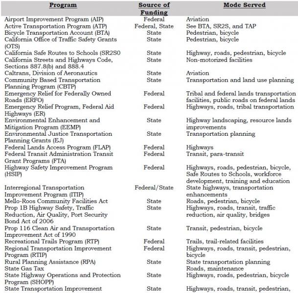
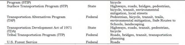
Airport Improvement Program (AIP)
The Federal Aviation Administration (FAA) provides funding for airport planning and development projects that enhance capacity, safety, security, and mitigate environmental issues. FAA grants have been utilized by the County and the Town for airport improvements. Funding is available through FY 2015 at 90% federal participation/10% local participation.
Active Transportation Program (ATP)
The Active Transportation Program consolidates various federal and state programs into a single program with the intent of making California a national leader in active transportation (biking, walking, other non-motorized transportation modes). The purpose of ATP is increased use of active modes of transportation and, in doing so, to increase safety and mobility, help achieve greenhouse gas reduction goals, enhance public health, ensure that disadvantaged communities share equally in the benefits of the program, and provide a broad spectrum of projects to benefit a variety of active transportation users. The ATP includes the Bicycle Transportation Account (BTA), the California Safe Routes to School (SR2S), Environmental Enhancement and Mitigation Program (EEMP), and the Transportation Alternatives Program (TAP).
Bicycle Transportation Account (BTA)
The BTA funds projects that improve safety and convenience for bicycle commuters in jurisdictions with an adopted Bicycle Transportation Plan (BTP). The BTA is now part of the ATP.
California Office of Traffic Safety (OTS) Grants
OTS grants fund bicycle and pedestrian safety and educational program on a competitive basis.
California Safe Routes to School (SR2S)
Eligible projects for SR2S funds include infrastructure projects in the vicinity of a school, as well as traffic education and enforcement activities within approximately two miles of an elementary or middle school. Other eligible non-infrastructure activities do not have a location restriction. SRTS infrastructure projects are eligible for TAP funds and may be eligible in the HSIP or STP. The SR2S is now part of the ATP.
California Streets and Highways Code Sections 887.8(b) and 888.4
These sections of State Code permit Caltrans to construct and maintain non-motorized facilities where such improvements will increase the capacity or safety of a state highway.
Caltrans, Division of Aeronautics, Grants and Loans
The California Aviation System Plan (CASP) identifies eligible projects for the State’s aviation funding programs. These programs provided grants and loans to eligible programs for capital improvements, land acquisition, and planning projects. Eligibility for some grants requires inclusion in the STIP. Includes Acquisitions and Development (A&D) Grant Program, Annual Credit Grants, Airport Loan Program, and State AIP Matching Grants.
Community-Based Transportation Planning (CBTP) Grant Program
This program provides funding for coordinated land use and transportation planning process that results in public engagement, livable communities, and a sustainable transportation system. Caltrans administers the program; for FY 2013-14 the grant cap is $300,000.
Emergency Relief Program for Federal-Aid Highways (ER)
Emergency Relief for Federally Owned Roads (ERFO)
These programs provide funds to repair federal-aid highways and roads on federal lands that have been damaged by natural disasters or catastrophes. The federal funds are meant to supplement state and local funds.
Environmental Enhancement and Mitigation Program (EEMP)
This is a State program funded by gas tax moneys, which provides grants to mitigate the environmental impacts of modified or new public transportation facilities. Grants are awarded in four categories: Highway Landscaping and Urban Forestry; Resource Lands; Roadside Recreation; and Mitigation Beyond the Scope of the Lead Agency. Grants are generally limited to $350,000. Grant proposals are evaluated by the California Natural Resources Agency; funds are administered by Caltrans. The EEMP is now part of the ATP.
Environmental Justice Transportation Planning Grants (EJ)
This program is administered by Caltrans and focuses on projects that address transportation and community development issues relating to low-income, minority, Native American, and other under-represented communities. The goal of the program is to improve mobility, access, safety, affordable housing opportunities and economic development opportunities for those groups.
Federal Lands Access Program (FLAP)
This program is a component of MAP-21, and is a replacement for the Federal Lands Highway Program. FLAP supplements state and local funding to improve transportation facilities that provide access to, are adjacent to, or are located within federal lands, particularly those that serve high-use recreation sites and economic generators.
Federal Transit Administration (FTA) Transit Grant Program
FTA grants provide funding for a variety of transit-related programs and activities.
- FTA Section 5304, Transit Planning Grant Program, provides funding for transit and/or intermodal planning studies in areas with populations under 100,000.
- FTA Section 5310, Elderly Individuals & Individuals with Disabilities, provides discretionary capital funds to meet the transportation needs of elderly persons and persons with disabilities. Grants may be awarded to public transit operators or private nonprofit organizations.
- FTA Section 5311, Rural Area, provides capital and operating expenses for non-urbanized transit systems in rural areas. A portion is set aside for Native American tribes.
- FTA Section 5311(b)(2)(3), Rural Transit Assistance Program (RTAP), provides funds for training, technical assistance, research, and related support services for transit operators in non-urbanized areas.
Highway Safety Improvement Program (HSIP)
A component of MAP-21 and a core federal-aid program that focuses on significantly reducing fatalities and serious injuries on all public roads, including non-State-owned public roads and roads on tribal lands.
Mello-Roos Community Facilities Act
This act allows local governments or districts to establish a Mello-Roos Community Facilities District (CFD) to provide for financing public improvements and services where no other money is available.
Prop 1B – The Highway Safety, Traffic Reduction, Air Quality, and Port Security Bond Act of 2006
Bond revenues for the following uses:
- Congestion Reduction, Highway and Local Road Improvements – for capital improvement projects to reduce congestion and increase capacity on state highways, local roads, and public transit;
- Safety and Security – for projects to protect against a security threat or improve disaster response capabilities on transit systems, as well as grants to seismically retrofit bridges, ramps, and overpasses; and
- Goods Movement and Air Quality – for projects to improve the movement of goods on state highways. Can also be used to improve air quality by reducing emissions related to goods movement and replacing or retrofitting school buses (that portion is administered by the California Air Resources Board).
Prop 116 – Clean Air & Transportation Improvement Act of 1990
Non-urban county transit funds can be made available for transit or non-motorized facilities. There has been some difficulty in approving allocations under Prop 116 due to the State’s fiscal problems.
Recreational Trails Program (RTP)
MAP-21 amended this program to make funding for recreational trails projects a set-aside from the State’s TAP funds, unless the Governor opts out in advance.
Rural Planning Assistance (RPA)
Rural Planning Assistance (RPA) funding is for state transportation planning activities and is allocated annually based on a population formula.
State Highway Operations & Protection Program (SHOPP)
The SHOPP provides funding for maintenance of the State Highway System. Projects are nominated within each Caltrans District office and are sent to Caltrans Headquarters for programming. Final projects approval is determined by the CTC, with funding prioritized for critical categories (emergency, safety, bridges, and pavement preservation). The State currently has insufficient funds to maintain the existing transportation infrastructure and there is no set formula for allocating SHOPP funds.
State Transportation Improvement Program (STIP)
The STIP is a five-year capital improvement program for the planning and implementation of capital improvements to the transportation system, including improvements to mobility, accessibility, reliability, sustainability and safety. The STIP includes two components, the Regional Transportation Improvement Program (RTIP) and the Interregional Transportation Improvement Program (ITIP). The RTIP receives 75% of the STIP funds, and the ITIP receives 25% of the funds.
The RTIP is prepared by the Mono County LTC and approved by the CTC as a part of the STIP, generally every two years. The ITIP is prepared by Caltrans and approved by the CTC as part of the STIP, although regional agencies can provide input and seek co-funding for specific ITIP projects in their region.
Surface Transportation Program (STP)
STP funding can be used for projects to preserve and improve the conditions and performance on any federal-aid highway, bridge, and pedestrian projects, including environmental restoration and pollution abatement. A portion of the STP is set aside for TAP and State Planning and Research.
Transportation Alternatives Program (TAP)
The TAP is a new program established by MAP-21 that provides funding for alternative transportation projects, including on- and off-road pedestrian and bicycle facilities, infrastructure projects for improving non-driver access to public transportation and enhanced mobility, community improvement activities, and environmental mitigation; recreational trail projects; safe routes to school projects; and projects for planning, designing, or constructing boulevards and other roadways largely in the right of way of former divided highways. TAP projects are not required to be located along Federal-aid highways. The TAP is a competitive program and is not included in the STIP. The TAP is now part of the ATP.
Transportation Development Act (TDA)
The Transportation Development Act (TDA) of 1971 created two funds primarily for public transportation: the State Transit Assistance (STA) account and the Local Transportation Fund (LTF). These are funded by a share of the state sales tax that is returned to the county of origin to support transit programs. In areas having no unmet transit needs, the funds may be spent for transportation planning or street and road purposes, at the discretion of the LTC. LTF funds are presently divided proportionately between the Town (55 %) and the County (45 %). LTF funds can be used as local matching funds for either state or federal funds. LTF funds are a traditional revenue source for Mono County and the Town.
Tribal Transportation Program (TTP)
The Tribal Transportation Program supports projects that improve access to and within tribal lands. Under Map-21, the TTP replaces the Indian Reservation Roads program, and adds new set-asides for transportation and tribal safety projects. Eligible activities include transportation planning, engineering, and maintenance, the construction, restoration, or rehabilitation of transportation facilities, environmental mitigation, and the operation and maintenance of transit facilities that are located on or provide access to tribal lands.
U.S. Forest Service
The USFS places a fee on all timber receipts from national forests. States then receive 25% of the receipts from timber sales within their boundaries, which are passed through to local agencies to benefit roads and schools in the counties where the sales occurred. In Mono County, this revenue becomes part of the county Road Fund, to be used for operational improvements.
Potential Additional Funding Sources
Other local funding sources may be available in Mono County should state and federal funding sources prove insufficient in the future, including funding for ongoing maintenance and rehabilitation projects for existing facilities. The following local funding sources could be used in Mono County and the town of Mammoth Lakes:
General Fund
Moneys come from a variety of sources, including property tax, business license tax, bed tax, motor vehicle in-lieu fees, and other fees levied by the Town and County. General fund moneys can be used to pay a portion of capital costs, or to cover budget items normally covered by LTF moneys. It is important that a local commitment be present to attract grant sources.
Development Impact Fees
Development Impact Fees may be available to offset potential transportation-related impacts identified for specific projects.
Public/Private Partnerships
Funding may be available from local agencies and private organizations. Recent cooperation between the USFS and the community of Lee Vining resulted in the construction of the Lee Vining community trail, and a local snowmobile enthusiasts group has helped develop signed snowmobile trails on public lands. In addition, it may be possible to obtain assistance from local groups and businesses in the construction and maintenance of bikeway facilities through a sponsorship program similar to the Adopt-A-Highway program implemented by Caltrans.
Other Local Sources
Other local sources may be available should state and federal funding sources prove insufficient for future projects:
Increase in Transient Occupancy Tax (TOT)
Condominium Use Tax
Local Gas Tax
Special Transportation Taxes
Fees and Charges for Services
Developers’ Contribution
Mitigation Fees
Revenue Bond
Lease Purchase Acquisition
Grants-in-Aid
Benefit Assessment Districts
County Service Area Improvement Area Bonds
Major Thoroughfare Fees
Finance Plan
Relationship Between the RTP Financial Element and the STIP
Most of the highway and road system in Mono County is either federal or state highways. As a result, the County relies heavily on the STIP and SHOPP to fund transportation improvements and maintenance projects on surface roads in the county. Projects in the Mono County RTP Financial Element are aligned with the STIP and the RTIP in order to provide consistency with those documents and in order to ensure maximum funding for projects in the county.
Existing Transportation System Operating Costs
Current projected transportation system operating costs for Mono County and the Town of Mammoth Lakes are shown in Appendix D. Those costs include the costs to operate and maintain the existing transportation system in Mono County, including the cumulative cost of deferred maintenance on the existing infrastructure. Current revenue projections for the operations and maintenance of the existing transportation system are also shown in Appendix D for both the County and the Town. For the County, Fiscal Year 2012-13 shows actual revenues & expenditures, FY 2013-14 is based on the current budget and the remaining are based on a 2% projected growth factor, except the General Fund which is projected to remain stable.
Costs & Revenue Projections for Transportation System Improvements
This section includes estimates of costs and revenue projections for transportation system improvements recommended in the Action Element, by mode and by recipient agency.
Revenues allocated for transportation purposes by Mono County have traditionally included revenues restricted to transportation uses, such as state fuel taxes (Streets and Highways Code Section 2104 and 2106), vehicle code fines, forest reserve payments, Local Transportation Funds, State Transit Assistance Funds, developers’ fees and direct assessment, and Federal-Aid Secondary. In addition, certain non-restricted funds have traditionally been used, including motor vehicle in-lieu fees, minor property rents, and federal revenue sharing. In recent years, the County has received transportation grant moneys for airport improvements and transit and has also appropriated General Fund contingency moneys when faced with emergency road repair needs.
Highways
Costs and revenue projections for proposed transportation system improvements on highways within Mono County are contained in the STIP and SHOPP (see Appendix D).
Local Roadways
Cost and revenue projections for eligible roadway construction and rehabilitation projects are contained in the STIP (see Appendix D).
Transit
Annual operating costs for transit services in Mono County are supported by LTF and STA funds. To provide sustainable funding for transit the Town of Mammoth Lakes has implemented year-round transit service. Those services are funded by a Transient Occupancy Tax (TOT) increment, along with a Transit Fee assessment, and/or funding from Transit Community Facilities District 13-003. These funding sources provide over $750,000 from the TOT and $220,000 from Transit Fee assessments. In addition, Community Facilities District 13-003 is expected to generate over $500,000 annually in the future.
Contract winter transit services are provided in the town of Mammoth Lakes to the Mammoth Mountain Ski Area, through an agreement with the Mammoth Mountain Ski Area. This winter service is privately funded and includes capital replacement costs. Summer Transit services are provided to the Reds Meadow Valley under a Special Use Permit with the USFS. One hundred percent of the operating funds for that service are provided though passenger fares.
Capital improvements to the system (e.g., bus purchases) are funded by grants or STIP funds. In addition, funds may be available for capital and expense requirements for design, development and implementations of the Eastern Sierra rural ITS transit system (i.e., bus-stop/electronic kiosks in town and county communities; bus-to-bus communications equipment) and transit management equipment.
Interregional Connections
Recommended actions for interregional connections include continued participation in YARTS and the Sierra Nevada ITS Strategic Plan planning process. Mono County contributes funding to YARTS annually.[18] The Action Element also recommends continued participation in the intercity transit planning process with Inyo and Kern counties and Caltrans, and the collaborative planning process with Inyo, Kern, and San Bernardino to pool STIP funds for priority projects. Neither of those collaborative planning processes currently has any associated hard costs.
Aviation
Project funding for identified short-term capital improvements at County airports is anticipated to come from a combination of FAA Airport Improvement Program grants (90%) and local match (10%). Projected costs for improvements at the Lee Vining Airport and Bryant Field are shown in Appendix D. Project funding for identified improvements at the Mammoth Yosemite Airport is anticipated to come from a combination of FAA grants (approximately 90%) and local match (approximately 10%). Projected costs for improvements at the Mammoth Yosemite Airport are shown in Appendix D.
Non-Motorized Facilities
Improvements to non-motorized facilities in Mono County have been included in the STIP. RTP policies call for the provision of bike lanes as a component of rehabilitation projects on streets and highways. The Town of Mammoth Lakes adopted policies in the 2007 General Plan to reduce vehicle trips and promote healthy communities by promoting feet first, transit second and automobile last. This policy is being implemented through project development review and Town-sponsored projects. In addition, the Town’s recent zoning update included development standards promoting pedestrian, biking, and alternative modes of transportation.
Financially Constrained Projects
This section contains a list of financially constrained projects for which funding has been identified, or is reasonably expected to be available within the RTP planning horizons (short-term and long-term). See Appendix D for the current STIP.
Financially Unconstrained Projects
The Mono County LTC has developed a list of financially unconstrained projects (projects that are both necessary and desirable should funding become available), which is included in Appendix D.
Potential Funding Shortfalls or Surpluses
Current funding sources are insufficient to maintain or even modestly improve Town and County road systems. Many roads in community areas throughout the county are unimproved private roads that have not been accepted in the county Road Maintenance System because of their substandard conditions. Liability issues and funding shortages impede the County's ability to accept ownership of substandard private roads. Maintenance of these roads therefore depends on private funding, which is often inadequate. Future additions to the County road system will be improved since it is the County's policy to require developers to pay for appropriately engineered streets for each new subdivision.
The fact that Mono County has a resident population of 14,202 persons according to Census 2010 and a private land base of only 6% of its total area severely limits the availability of funding for improvements to its transportation system. State redistribution of gas tax revenues and other transportation funds is based primarily on the resident population of each county and length of road system. Factors such as origination point of funds, traffic volumes, recreational benefits, travel alternatives, and need are given little weight in the State distribution formula. Mono County with its small resident population does not qualify for sufficient funding to address the impacts of the large tourist traffic volumes experienced in the county.
[18] The funding contribution for FY 2014-15 was $30,000.
Airport Land Use Compatibility Plan: A plan adopted by an Airport Land Use Commission, which sets forth policies for promoting compatibility between airports and the land uses that surround them.
All Users: Users of streets, roads and highways including bicyclists, children, persons with disabilities, motorists, movers of commercial goods, pedestrians, users of public transportation and seniors.
Arterial: A major street carrying the traffic of local and collector streets to and from freeways and other major streets, with controlled intersections and generally providing direct access to properties.
Bicycle Boulevard: The Bicycle Boulevard Design Guidebook defines a Bicycle Boulevard as “low volume” and low-speed streets that have been optimized for bicycle travel through treatments such as traffic calming and traffic reductions, signage and pavement markings, and intersection crossing treatments.
Bicycle Lane: According to Caltrans’ Highway Design Manual, Chapter 1000, a bicycle lane is a Class II Bikeway and provides a striped lane for one-way bicycle travel on a street or highway.
Bicycle Path: According to Caltrans’ Highway Design Manual, Chapter 1000, a bicycle path is a Class I Bikeway and provides a completely separated right of way for the exclusive use of bicycles and pedestrians with cross flow by motorists minimized.
California Aviation System Plan (CASP): Prepared by Caltrans every five years to integrate regional system planning on a statewide basis.
California Transportation Commission (CTC): Formulates and evaluates state policies and plans for transportation programs. Approves the RTIP, the STIP, and the SHOPP.
Collector: A street for traffic moving between arterial and local streets, generally providing direct access to properties.
Connectivity: A well-connected circulation system with minimal physical barriers that provides continuous, safe, and convenient travel for all users of streets, roads, and highways.
Conventional Highway: According to the California Highway Manual, a conventional highway is, “a highway without control of access which may or may not be divided.” Grade separations at intersections or access control may be used when justified at spot locations.
Expressway: A highway with full or partial control of access with some intersections at grade.
Federal Highway Administration (FHWA): A component of the US Department of Transportation, established to ensure development of an effective national road and highway transportation system. Approves federal funding for transportation projects.
Federal State Transportation Improvement Program (FSTIP): A three-year list of transportation projects proposed for funding developed by the State in consultation with Metropolitan Planning Organizations and local non-urbanized governments. The FSTIP includes all FTIP projects and other federally funded rural projects.
Federal Transit Administration (FTA): A component of the US Department of Transportation, responsible for administering the federal transit program under the Federal Transit Act, as amended.
Federal Transportation Improvement Program (FTIP): A three-year list of all transportation projects proposed for federal funding, developed as a requirement of funding. In air quality non-attainment areas, the plan must conform to the SIP.
Freeway: A highway serving high-speed traffic with no crossings interrupting the flow of traffic (i.e., no crossings at grade). Streets and Highways Code §23.5, in part, states that “Freeway means a highway in respect to which the owners of abutting lands have no right or easement of access to or from their abutting lands or in respect to which such owners have only limited or restricted right or easement of access.”
Heliport: A facility used for operating, basing, housing, and maintaining helicopters.
Interregional Improvement Program (IIP): One of two broad programs under the STIP. Funded from 25 % of the SHA revenues programmed through the STIP.
Interregional Transportation Improvement Program (ITIP): Funds capital improvements on a statewide basis, including capacity-increasing projects primarily outside urbanized areas. Projects are nominated by Caltrans and submitted to the CTC for inclusion in the STIP. Has a four-year time frame and is updated biennially by the CTC.
Level of Service (LOS) is a qualitative measure describing operational conditions as perceived by motorists within a traffic stream. LOS generally describes these conditions in terms such as speed and travel time, freedom to maneuver, traffic interruptions, comfort and convenience, and safety. Current LOS conditions are based on the latest traffic counts. Projected LOS conditions are based on growth factors derived from historical growth trends.
Local Scenic Highway: A segment of a state or local highway or street that a city or county has designated as “scenic.”
Local Street: A street providing direct access to properties and designed to discourage through traffic.
Local Transportation Commission (LTC): The Mono County LTC is the Regional Transportation Planning Authority (RTPA) for Mono County.
Major Thoroughfare: A major passageway such as a street, highway, railroad line, or navigable waterway that serves high traffic volumes.
Multi-modal Transportation Network: A well-balanced circulation system that includes multiple modes of transportation that meets the needs of all users of streets, roads, and highways.
National Scenic Byway: A segment of a state or interstate highway route that the USFS has designated as a scenic byway or which another federal agency has designated as a national scenic and recreational highway.
Official County Scenic Highway: A segment of a county highway the Director of Caltrans has designated as “scenic.”
Official State Scenic Highway: A segment of a state highway identified in the Master Plan of State Highways Eligible for Official Scenic Highway Designations and designated by the Director of Caltrans.
Paratransit: Transportation systems such as jitneys, carpooling, vanpooling, taxi service, and Dial-A-Ride arrangements.
Recreational Trails: Public areas that include pedestrian trails, bikeways, equestrian trails, boating routes, trails, and areas suitable for use by persons with disabilities, trails and areas for off-highway recreational vehicles, and Nordic (cross country) skiing trails.
Regional Improvement Program (RIP): One of two broad programs under the STIP. Funded from 75% of the STIP funds, divided by formula among fixed county shares. Each county selects the projects to be funded from its county share in the RTIP.
Regional Transportation Improvement Program (RTIP): A list of proposed transportation projects submitted to the California Transportation Commission by the RTPAs for state funding. Has a four-year time frame and is updated biennially by the CTC.
Regional Transportation Plan (RTP): Plan prepared biennially by regional transportation planning agencies (e.g., Mono County Local Transportation Commission, “LTC”) that describes existing and projected transportation needs, actions and financing for a 20-year period.
Route: A sequence of roadways, paths, and/or trails that allow people to travel from place to place.
Scenic Highway Corridor: The visible area outside the highway’s right of way, generally described as “the view from the road.”
State Highway Account (SHA): The primary State funding source for transportation improvements. Includes revenue from the state fuel tax, truck weight fees, and federal highway funds. Provides funding for a) non-capital outlays (maintenance, operations, etc.), b) STIP, c) SHOPP, and d) local assistance.
State Highway Operations and Protection Program (SHOPP): California state program intended to maintain the integrity of the state highway system, focusing primarily on safety and rehabilitation issues. A four-year program of projects approved by the CTC separately from the STIP cycle. See www.dot.ca.gov/hq/tpp/Offices/Planning/for further information.
State Implementation Plan (SIP): An air quality plan developed by the California Air Resources Board in cooperation with local air boards to attain and maintain Federal Clean Air Standards. See www.arb.ca.gov for further information.
State Transit Assistance (STA): Funds derived from the Public Transportation Account. Fifty percent is allocated to Caltrans, 50% to the Regional Transportation Planning Authorities “RTPAs” (e.g., Mono County Local Transportation Commission “LTC”). The funds allocated to the RTPAs are available for mass transit projects (50%) and transit operators (50%).
State Transportation Improvement Program (STIP): Includes transportation programs proposed in RTIPs and ITIPs, approved for funding by the CTC. See www.dot.ca.gov/hq/tpp/Offices/Planning/ for further information.
Terminal: A station, stop, or other transportation infrastructure along or at the conclusion of a transportation route. Terminals typically serve transportation operators and passengers by air, rail, road, or sea (i.e., airports, railroad depots, transit stops and stations, and ports and harbors.
Transit-Oriented Development (TOD): A moderate- to high-density development located within an easy walk or bicycle of a major transit stop, generally with a mix of residential, employment, and shopping opportunities. TOD encourages walking, bicycling, and transit use without excluding the automobile.
Walkability: The measurement of how walkable a community is. Walkable communities typically include footpaths, sidewalks, street crossings, or other pedestrian-oriented infrastructure
Yosemite Area Regional Transportation System (YARTS): A regional system providing scheduled service from Madera, Mariposa and Mono counties to Yosemite, connecting with the Yosemite National Park shuttle service. In Mono County, the service departs from Mammoth Lakes, June Lake, and Lee Vining. See www.yosemite.com for further information.
Documents Consulted
Eastern Sierra Landownership Adjustment Project. 2010.
Bureau of Land Management
North of Bishop Vehicle Access Strategy Plan. 1993.
Resource Management Plan for the Bishop Resource Area. 1991.
Bureau of Land Management and Inyo National Forest
Draft OHV Plan. 1994.
California Air Resources Board
Recommendations of the Regional Targets Advisory Committee (RTAC) Pursuant to Senate Bill 375: A Report to the California Air Resources Board.
California Department of Transportation
Addressing Climate Change Adaptation in Regional Transportation Plans. 2013.
California Transportation Plan 2025. California Transportation Plan Themes. Draft, July 2001.
Regional Transportation Guidelines. 2010.
California Department of Transportation, Division of Aeronautics
California Aviation System Plan (CASP). 2013.
California Department of Transportation. District 9.
District 9 Planning Documents—Transportation Concept Reports and District System Management Plans.
US 395 Origination and Destination Study, Year 2011. 2014.
US 395 Transportation Concept Report. November 2014.
California Employment Development Department (EDD), Labor Market Information Division (LMID)
Employment and Industry Projections, 2001-2012. 2013.
California Office of Planning and Research
Update to the General Plan Guidelines: Complete Streets and the Circulation Element. 2010.
California Transportation Commission
Federal Transportation Improvement Program (FTIP).
Regional Transportation Improvement Program (RTIP).
State Transportation Improvement Program (STIP).
State Highway Operation and Protection Program (SHOPP).
Great Basin Unified Air Pollution Control District
Mono County Ozone Attainment Plan. 1991.
Regulation XII. Conformity to State Implementation Plans of Transportation Plans, Programs, and Projects Developed, Funded or Approved Under Title 23 U.S.C. or the Federal Transit Act. 1994.
Regulation XIII. Conformity of General Federal Actions to State Implementation Plans. 1994.
Great Basin Unified Air Pollution Control District and Town of Mammoth Lakes
Air Quality Management Plan for the Town of Mammoth Lakes. 1990.
Air Quality Maintenance Plan and Redesignation Request for the Town of Mammoth Lakes. 2014.
Institute of Transportation Engineers
Traffic Engineering Handbook, 4th Edition. 1992.
Katz, Okitsu & Associates
Goods Movement Study for US-395 Corridor. June 21, 2006.
Local Government Commission, et al.
Main Street Revitalization Plan for US 395 through Bridgeport. October 2013.
LSC Transportation Consultants, Inc.
Inyo-Mono Counties Coordinated Public Transit – Human Services Transportation Plan Update. April 4, 2014.
Mammoth Lakes Parking Study Draft. 2005.
Technical Memorandum: Mammoth Lakes Vehicle Miles Traveled Analysis. August 2012.
Technical Memorandum: Mammoth Lakes Vehicles Miles Traveled Analysis – Comparison with 1990 Study. September, 2013.
Mono County
Mono County Emergency Operations Plan. 2004.
Mono County Airport Land Use Commission
Airport Land Use Plan – Mammoth Yosemite Airport. 1998.
Comprehensive Land Use Management Plans – Bryant Field Airport and Lee Vining Airport. Updates 2012.
Mono County Local Transportation Commission
Bus Stop Master Plan. Draft 2005.
Mono County Regional Blueprint. 2012.
Mono County Planning Department
Bodie Hills Multi-modal Plan. 1994.
June Lake Area Plan. 1991.
June Lake Area Plan Final Environmental Impact Report. 1991.
June Lake Multi-modal Transportation Plan. 1994.
June Lake Loop Trail Plan/Map.
Mono County Bicycle Transportation Plan. Draft 2014.
Mono County General Plan and Updates. 1993 and 2001.
Mono County General Plan Environmental Impact Report. 1993.
Mono County Housing Element. Draft Update 2014.
Mono County Master Environmental Assessment and Updates. 1993 and 2001.
Mono County Resource Efficiency Plan. Draft 2014.
Mono County Trails Plan (including General Bikeway Plan). 1994.
Mono County Transit Plan. 1996.
Proposed Eastern Sierra Regional Trail (ESRT). Draft 2014.
Nelson\Nygaard Consulting Services
Community of Lee Vining. Pedestrian Safety on Highway 395. October 1998.
Nelson\Nygaard Consulting Services and the Mono County Collaborative Planning Team.
Mono County Job Creation Plan for 2000-2005. 1999.
Tribal Transportation Needs Assessment, Benton Reservation, Paiute Tribe. 2009.
Tribal Transportation Needs Assessment, Bridgeport Indian Colony, Paiute Tribe. 2009.
Nichols Consulting Engineers, Chtd.
Pavement Management System for Town of Mammoth Lakes. 2000.
Pavement Management System for Mono County. 2013.
The Housing Collaborative LLC et al.
Eastern Sierra Housing Needs Assessment. Draft 2004.
Town of Mammoth Lakes
2014-2015 Mammoth Lakes pM10 and Meteorological Summary. 2015.
Emergency Operations Plan (EOP). 2001.
Mammoth Lakes Fixed Route Transit Plan. 2005.
Mammoth Lakes General Bikeway Plan. 2014.
Mammoth Lakes General Plan. 2007.
Mammoth Lakes General Plan EIR. 2007.
Draft Mammoth Lakes Mobility Element. 2012.
Mammoth Lakes Pedestrian Master Plan.2014.
Mammoth Lakes Trail System Master Plan. 2011.
Mammoth Lakes Transit Plan. 2000.
Municipal Code. Chapter 8.30. Particulate Emissions Regulations. Proposed Update, 2013.
Municipal Wayfinding Master Plan. 2012.
Mammoth Lake Pavement Management System. 2000.
Mammoth Yosemite Airport Capital Improvement Plan. (2003).
Town of Mammoth Lakes and Great Basin Unified Air Pollution Control District
Air Quality Maintenance Plan and PM10 Redesignation Request for the Town of Mammoth Lakes. 2013.
U.S. Forest Service
Inyo National Forest Land and Resource Management Plan. 1990.
Toiyabe National Forest Land and Resource Management Plan. 1986.
Winter Recreation Map. 1993.
Inyo NF Travel Management Plan. 2009.
Walkable Communities Inc.
Walkable Communities for Mono County Report. Lee Vining, Crowley, June Lake, Mammoth Lakes and Bridgeport, California. Draft, January 30, 2000.
Weber Associates, Inc.
Mammoth/June Lakes Transportation Plan, Phase II - June Lake. 1982.
Yosemite Area Regional Transportation System (YARTS)
Short-Range Transit Plan. 2012 or 2013.
Websites Consulted
California Air Resources Board
Air emissions inventory data. Information on air quality and transportation planning.
California Department of Finance
Statistical Abstract, population and income data, other socio-economic data.
California Department of Motor Vehicles
Statistics on vehicles and drivers licensed in Mono County.
California Department of Transportation
Planning guidance, traffic counts.
California Highway Patrol
Collision information, roadway statistics.
California Labor Market Information, Employment Development Department
www.labormarketinfo.edd.ca.gov
Socioeconomic data, income and poverty data.
Eastern Sierra Transit Authority
Schedules and information about ESTA routes and Carson Ridgecrest Eastern Sierra Transit (CREST) routes.
Mono County
Links to Mono County departments and to the Local Transportation Commission. Also, Mono County documents online. Link to Mono County Rideshare Program (AlterNetRides).
Town of Mammoth Lakes
Links to Town departments. Town documents online.
U.S. Census Bureau
Population, income, and poverty data.
U.S. Department of Commerce, Bureau of Economic Analysis
Income, poverty, and other socioeconomic data.
U.S. Environmental Protection Agency (EPA)
Air quality data.
YARTS.
Information on YARTS.
Persons Consulted
Bridgeport Indian Colony
Justin Nalder
Caltrans, District 9
Ryan Dermody, Terry Erlwein, Forest Becket, and other staff
Great Basin Unified Air Pollution Control District.
Duane Ono
Marine Corps Mountain Warfare Training Center
Doug Power and Col. John Gamelin
Mono County Local Planning Groups.
Antelope Valley Regional Planning Advisory Committee
Benton/Hammil Regional Planning Advisory Committee
Benton Hotsprings Landowners
Bridgeport Valley Regional Planning Advisory Committee
Chalfant Regional Planning Advisory Committee
June Lake Citizens Advisory Committee and June Lake Trails Committee
Long Valley Regional Planning Advisory Committee
Mono Basin Regional Planning Advisory Committee
Oasis Landowners
Paradise Regional Planning Advisory Committee
Upper Owens Landowners
Mono County Public Works Department
Jeff Walters, Garrett Higerd, Paul Roten
Town of Mammoth Lakes.
Grady Dutton, Haislip Hayes, Brian Picken, Sandra Moberly, Jen Daugherty
In addition, per Government Code §65352.3 under Senate Bill 18, the following California Nation American Tribes identified by the Native American Heritage Commission were sent consultation letters:
Benton Paiute Reservation, Billie (Jake) Saulque
Big Pine Band of Owens Valley THPO, Bill Helmer
Big Pine Paiute Tribe of the Owens Valley, Genevieve Jones
Bishop Paiute Tribe, Gerald Howard and Raymond Andrews
Bridgeport Pauite Indian Colony, John L. Glazier
Kern Valley Indian Council, Robert Robinson
Mono Lake Indian Community, Charlotte Lange
Walker River Reservation, Melanie McFalls
Washoe Tribe of Nevada and California, Darrell Kizer
Methodology
Traffic demand projections for the unincorporated areas of Mono County are based on trip generation rates per individual dwelling units. Traditional trip generation rates are based on rates from Trip Generation, 7th edition, Institute of Transportation Engineers, which shows the average weekday trip generation rate of 9.57 trips per detached dwelling unit on a weekday. This trip generation rate is not accurate for Mono County. As an example, if 9.57 trips per detached dwelling unit were used, the community of June Lake would generate approximately 7,943 daily trips (830 dwelling units x 9.57). The highest Annual Average Daily Traffic (AADT) on SR 158 and Lakeview Drive in June Lake is 1,500 trips per day, or almost five times less than the traffic projection rates on a daily basis shown in Table A-8.
Projected trip generation rates while based on land use and the number of housing units are subject to local factors such as:
- The seasonal nature of visitors which tends to increase Average Annual Daily Traffic (AADT) during summer months,
- The opening or closing of mountain passes,
- Some communities may have a high number of second homeowners,
- The rural nature of some communities from job centers or work locations,
- Not all traffic will enter and/or exit state highways at one specific location, and/or
- Other factors.
Mono County is using an extremely conservative trip generation rate of six trips per dwelling unit. The number of current dwelling units comes from the US Census 2010 and shown as a Census Designated Place (CDP). The Land Use Element lists all projected uses within the county, but to simplify trip generation, only the single-family residential designation is used. Projected trip generation is calculated two ways. The first uses all the dwelling units in a CDP multiplied by six trips per unit. The second calculation uses all occupied units and 50% of the unoccupied dwelling units in a CDP multiplied by six trips per unit. The number of projected new units assumes a 1% growth rate based on total units and occupied units plus 50% of the unoccupied units over a five-year time frame.
Traffic/Trips by Planning Area
Average Annual Daily Traffic (AADT) is the total traffic volume for the year divided by 365 to pass over a certain section of roadway in one day. Peak Month ADT is the average daily traffic for the month of heaviest traffic flow. The most current five-year traffic volume reporting period on the state highway system is from 2009 through 2014 by the California Department of Transportation, Division of Traffic Operations.
Antelope Valley
The primary thoroughfare in Antelope Valley is US 395. Any growth in the Antelope Valley has the potential to impact US 395. There are approximately 688 current dwelling units (D.U.) in the Antelope Valley. A 1% growth rate over a five-year period would result in 52 new units. An additional calculation on growth rate is made using only 50% of the unoccupied units or 46 new units over five years. Trip generation rates for the Antelope Valley are included in Table A-1 for total units and occupied units plus 50% of the unoccupied units. Both are based on six trips per single-family unit. The communities of Topaz, Coleville, and Walker potentially add 230 or 203 daily new vehicle trips (over a five-year period) to current traffic conditions in the Antelope Valley.
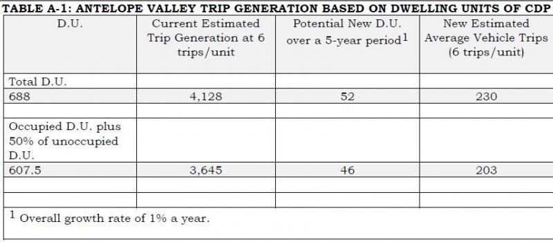
As a comparison, Table A-2 shows the annual average daily traffic (AADT) on U.S. Route 395 from 2009 to 2014 (Mill Creek Bridge and Highway 395). The most recent average daily total was 3,500 vehicles in 2014.
- If all D.U. are counted, the addition of 230 daily vehicle trips over a five year period represents a 6.5 percent increase in the average daily trips using the AADT from 2014.
- If all occupied D.U. plus 50 percent of the unoccupied D.U. are counted, the addition of 203 daily trips over a five year period represents a 5.8 percent increase in average daily trips using the AADT from 2014.
The impact of these additional trips over five years is expected to be minimal. Mono County is using a conservative trip generation rate of six trips per dwelling unit.
TABLE A-2: AVERAGE ANNUAL DAILY TRAFFIC MILL CREEK BRIDGE & HIGHWAY 395 (PM 107.105), ANTELOPE VALLEY
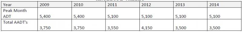
Bridgeport Valley
The primary thoroughfares for the Bridgeport area are Highways 395 and 182. There are currently 357 existing D.U. in the Bridgeport Valley. Trip generation rates for the Bridgeport Valley are based on six trips per single family dwelling. Bridgeport also has a large seasonal variation due to trans-sierra pass openings (Tioga 120 and/or Sonora 108) and second homeowners. Table A-3 shows generation rates in the Bridgeport Valley for total units and occupied units plus 50 percent of the unoccupied units. This could add 119 trips or 103 trips over a five year period. Both are based on six trips per single family unit.
TABLE A-3 BRIDGEPORT VALLEY TRIP GENERATION BASED ON Dwelling Units of CDP
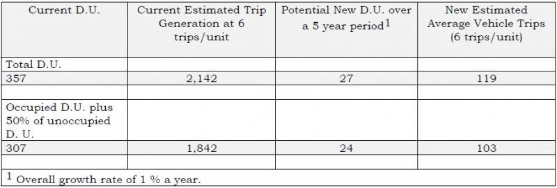
As a comparison, Table A-4 shows the annual average daily traffic (AADT) on U.S. Route 395 from 2009 to 2014 (395 & 182). The most recent average daily total was 3,600 vehicles in 2014.
- If all D.U. are counted, the addition of 119 daily vehicle trips over a five year period represents a 3.5 percent increase in the average daily trips using the AADT from 2014.
- If all occupied D.U. plus 50 percent of the unoccupied D.U. are counted, the addition of 103 daily trips over a five year period represents a 3.0 percent increase in average daily trips using the AADT from 2014.
The impact of these additional trips over five years is expected to be minimal. Mono County is using a conservative trip generation rate of six trips per dwelling unit.
TABLE A-4: AVERAGE ANNUAL DAILY TRAFFIC JUNCTION HIGHWAYS 395 AND 182 (PM 76.3), Bridgeport Valley
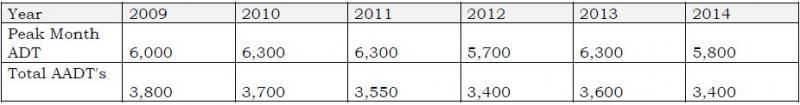
Mono Basin
Main travel routes in the Mono Basin area are Highways 395, 120 and 167. Trip generation rates for the Mono Basin are based on single family units. Lee Vining also has a large seasonal variation in AADT due to trans-sierra pass openings (Tioga 120 and/or Sonora 108). Trip generation rates for the Mono Basin are shown in Table A-5 for total units and occupied units plus 50 percent of the unoccupied units. Both are based on six trips per single family unit.
(INSERT TABLE A-5)
As a comparison, Table A-6 shows the annual average daily traffic (AADT) on U.S. Route 395 from 2009 to 2014 (North end of Lee Vining). The most recent average daily total was 3,600 vehicles in 2014.
- If all D.U. are counted, the addition of 70 daily vehicle trips over a five year period represents a 1.89 percent increase in the average daily trips using the AADT from 2014.
- If all occupied D.U. plus 50 percent of the unoccupied D.U. are counted, the addition of 59 daily trips over a five year period represents a 1.59 percent increase in average daily trips using the AADT from 2014.
The impact of these additional trips over five years is expected to be minimal. Mono County is using a conservative trip generation rate of six trips per dwelling unit.
(Insert Table A-6)
June Lake
Access to the community of June Lake is provided by Highway 158. Traffic generation rates for June Lake are based on single family residential units (SFR). June Lake also has the potential to have a high number of second home owners, seasonal variations, and may be influenced by trans-sierra pass openings (Tioga 120 and/or Sonora 108) which would affect the average annual daily traffic figures. Trip generation rates are shown in Table A-7 for total units and occupied units plus 50 percent of the unoccupied units. Both are based on six trips per single family unit.
(Insert Table A-7)
As a comparison, Table A-8 shows the annual average daily traffic (AADT) on State Route 158 from 2009 to 2014 (June Lake Village). The most recent average daily total was 1,500 vehicles in 2014.
- If all D.U. are counted, the addition of 274 daily vehicle trips over a five year period represents a 18.2 percent increase in the average daily trips using the AADT from 2014.
- If all occupied D.U. plus 50 percent of the unoccupied D.U. are counted, the addition of 186 daily trips over a five year period represents a 12.4 percent increase in average daily trips using the AADT from 2014.
This rate seems highly unlikely due to the fact that the estimated trip generation from all 820 existing units if occupied at one time could equal 4,920 trips on SR 158. This is three times higher than the AADT of 1,500 trips from 2014 on SR 158 as shown in Table A-8.
As stated in the methodology section, the ITE methodology of 9.57 trips per detached dwelling unit in rural Mono County results in unrealistic figures. Mono County has adjusted this methodology to a more reasonable, and still conservative, six trips per dwelling unit. This adjustment clearly continues to provide unrealistic numbers as described in the preceding paragraph; however, alternative methodology is lacking at this time. The current methodology does not account for second homeownership (e.g. a high percentage of vacant dwelling units), transient rentals and occupancy, concentrated traffic influx during limited timeframes due to tourist visitation, and a seasonal road closure that eliminates through traffic on SR 158.
The Average Annual Daily Traffic data does show a decrease on SR 158 from 2009 to 2014. . The impact of these additional trips over five years is not expected to be significant. Mono County is using a very conservative trip generation rate of six trips per dwelling unit as shown in Table A-7 with the trip generation rate exceeding the peak month ADT of 2,800.
(Insert Table A-8)
Long Valley
The primary access between communities in Long Valley is Highway 395. This area includes the Long Valley communities and Wheeler Crest. It does not include the Town of Mammoth Lakes. Long Valley trip generation rate is six trips per unit. A one percent housing growth rate over five years would add 63 new units if all dwelling units are used or 54 new units if all occupied units plus 50 percent of unoccupied units are used to calculate future growth shown in Table A-9.
(Insert Table A-9)
As a comparison, Table A-10 shows the annual average daily traffic (AADT) on US 395 from 2009 to 2014 at two different locations. The most recent average daily total in 2014 was 6,900 at McGee Creek Road and 8,300 at SR 203.
If all D.U. are counted, the addition of 281 daily vehicle trips over a five year period represents a four percent increase in the average daily trips using the AADT from 2014 at the Mc Gee Creek Road location.
If all occupied D.U. plus 50 percent of the unoccupied D.U. are counted, the addition of 240 daily trips over a five year period represents a 3.4 percent increase in average daily trips using the AADT from 2014 at the Mc Gee Creek Road location.
The impact of these additional trips over five years is not expected to be significant. Mono County is using a conservative trip generation rate of six trips per dwelling unit.
(Insert Table A-10)
Tri-Valley
The Tri Valley Area includes the communities of Chalfant, Hammil, and Benton. The primary thoroughfare is Highway 6. There are currently 460 existing dwelling units in the area. Trip generation rates for the Tri-Valley are based on single family detached housing. A one percent growth rate over five years using all occupied units would add 35 new units or using occupied units and 50 percent of unoccupied units would add 32 units. This would generate approximately 154 potential trips in the Tri-Valley area as shown in Table A-11.
(Insert Table A-11)
The additional projected 154 trips would utilize Highway 6 as this is the primary north/south route to Bishop. A lessor number of trips could utilize SR 120 in the northern portion of the Tri-Valley.
As a comparison, the average daily traffic on Highway 6 is only 1,890 at the junction of SR 120 (Benton Station) and 2,100 at Silver Canyon Road in northern Inyo County (see Table A-12).
If all 154 trips from new residential development traveled south into Inyo County, this would represent an increase of 6.4 percent of the 2014 AADT at the Inyo/Mono County Line as shown in Table A-12.
The impact of these additional trips over five years is not expected to be significant. Mono County is using a conservative trip generation rate of six trips per dwelling unit.
(Insert Table A-12)
(Insert Table A-13)
(Insert Table A-14)
Potential Local Transportation Projects – Examples of Project Types:
- Providing sufficient shoulders to allow for bike lanes and pedestrian paths;
- Providing additional bicycle and pedestrian facilities;
- Provision of safety and educational activities for pedestrians and bicyclists;
- Acquisition of scenic easements and scenic or historic sites;
- Scenic or historic highway programs (including the provision of tourist and welcome center facilities);
- Landscaping and other scenic beautification;
- Historic preservation;
- Rehabilitation and operation of historic transportation buildings, structures or facilities (including historic railroad facilities and canals);
- Preservation of abandoned railway corridors (including the conversion and use thereof for pedestrian or bicycle trails);
- Control and removal of outdoor advertising;
- Archaeological planning and research;
- Environmental mitigation to address water pollution due to highway runoff or reduce vehicle-caused wildlife mortality while maintaining habitat connectivity;
- Establishment of transportation museums;
- Providing turnouts and parking areas for all season recreational use and sightseeing;
- Providing fisheries enhancement projects in waterways affected by highway improvements;
- Providing additional deer warning signs in areas of heavy deer use and/or improving existing signage to emphasize the hazard in the area;
- Providing wildlife guzzlers and enhancing forage to keep wildlife from crossing highways;
- Enhancing visually objective uses alongside highways through screening, painting, fences, etc.; and
- Providing interpretive/information signs and exhibits.
Potential Local Transportation Projects by Area/Road
US 395 Antelope Valley
- Acquisition of nearby deer habitat areas.
- Enhancement of deer habitat on the west side of 395 to reduce the number of highway crossings.
- Enhance available water and forage for deer.
- Install additional deer-crossing warning signs.
- Establish roadside turnouts/deer view areas (these would be more appropriate in the Eastside Lane area, although interpretive signs directing people to Eastside Lane may be appropriate on US 395).
- Establish screening vegetation for deer around Marine housing complex, in cooperation with BLM and Marine Corps.
- Widen shoulders to allow for vehicle turnouts and scenic viewing.
SR 182 Walker River Bridge Project (at Bridgeport Reservoir Dam)
- Enhance swallow habitat.
- Enlarge existing turnout/parking area and include interpretive facilities.
- Improve SR 182 to include a bikeway to the state line.
- Provide for improved pedestrian access & crossings on the north/south sides of the bridge.
US 395 Bridgeport Main Street
- Construct northern sidewalk gap on the west end of town from Buster’s Market site to existing sidewalk.
- Improve northern sidewalk from Burger Barn to Walker River Lodge.
- Add southern sidewalk section on west end of town from Twin Lakes Road to the rodeo grounds.
- Construct (removable) curb extensions and pedestrian-activated warning lights at existing crosswalks.
- Improve walkability using features such as pedestrian furniture, pedestrian-scale street lighting, trash/recycling receptacles, bike racks, additional crosswalks, and street trees/landscaping beautification.
- Design and construct signage and wayfinding for the town core.
- Design and construct gateway monument signs at the ends of town.
Bridgeport Valley Trails
- Provide for a mountain biking trail in the Bridgeport vicinity.
- Maintain existing trails.
Twin Lakes Road Resurfacing (Bridgeport)
- Construct bike lane along shoulder or parallel to existing route, for approximately 13 miles.
- Enhance wetland values or provide replacement wetlands.
US 395 Conway Summit Passing Lane
- Complete four-laning or passing lane addition on US 395 north of Conway Summit.
- Install interpretive signs at Mono Basin Overlook regarding deer migration and restrooms.
- In conjunction with Cemetery Road project, enhance forage on BLM and State lands.
- Preserve via land purchase or other measures scenic Mono Basin properties.
- Rehabilitate/stabilize Conway Summit road cuts.
Big Virginia Lake Road and Trailhead Improvements
- Provide access/fishing pier at Big Virginia Lakes.
- US 395 Cemetery Road Passing Lane
- Fisheries enhancement in Mill Creek (creation of pools, fencing to exclude sheep, providing for fish passage through upstream diversions on Mill Creek).
- Enhance forage on BLM and State lands.
- Vista pullout and parking for Mono Lake viewing and Mill Creek access.
US 395 Four-Lane Project Between Lee Vining and June Lake
- Mono Basin Scenic Area viewpoint.
- Improve wildlife habitat.
- Interpretive turnout/parking area to highlight Walker/Parker/Rush Creek restoration.
- Lee Vining Creek interpretive signing, trail construction, and trailhead parking, coordinated with community and USFS current trail efforts.
- Visual enhancement of US 395/SR 120 junction.
- SR 120 pullouts and parking for Mono Lake viewing, visitor orientation, interpretive and information station.
- Walker and Rush creeks, access parking for fishing, hiking, etc.
- North US 395/SR 158 junction, information station to provide visitors with recreation opportunities around June Lake Loop.
US 395 – Sand House Grade Segment
- June Lake Junction self-serve information station (kiosk). Cooperative project to provide visitors with recreation opportunities around June Lake Loop.
- Pullout, scenic viewing facilities, and trail to view Mono Lake (halfway point).
- Deer watering facility at base of Sand House Grade to reduce highway crossings.
- Trailhead parking for Nordic (cross country) skiers and snowmobilers at June Lake Junction (could also be used as park-and-ride facility for commuters).
- Snowmobile crossing north of June Lake Junction.
- Parking near Bouldering Sites.
SR 158 Improvements – June Lake Loop
- Pullouts and interpretive exhibits at key points along the Scenic Byway (tied to Avalanche Bypass Road and widening projects).
- Silver Lake Roadside Bike/Pedestrian Path (tied to widening projects).
- Drainage improvements in the Village (tied to future circulation improvements in the Village). Provide drainage improvements, such as reconstructing June Lake outfall to Gull Lake inlet, and constructing a sedimentation barrier at the Gull Lake inlet.
- Parking and interpretive and rest facilities at June Lake Ballfield/Roadside Park.
- Down Canyon Trail project development and construction.
US 395 Improvements along Deadman Grade Segment
- Snowmobile trailhead (parking, information station, restroom) off Logging Camp Road.
- Nordic ski trailhead (parking, information station, restroom) off Obsidian Dome Road.
- Snowplay parking at top of Deadman Grade (allow safe parking at existing site).
Benton Crossing Road
- Erosion control for graded section of Benton Crossing Road from Watterson Grade to SR 120. Erosion control along this 15-mile section will involve approximately 36-40 acres at a cost of approximately $4,000 per acre, or a total cost of $145,500.
- Deer habitat improvement.
Lower Rock Creek Road
- Construct bike lane from south county line to US 395 (approximately nine miles).
- Develop bridge on Lower Rock Creek Trail.
Current Improvement Programs
- Mono County Highway Improvement Programs
- Mono County Roadway Improvement Program
- Town of Mammoth Lakes Roadway Improvement Program
- Mono County Airport Capital Improvement Programs
- Town of Mammoth Lakes Airport Capital Improvement Programs
- Mono County Unconstrained Projects List
Current Financing
- Mono County Projected Transportation System Operating Costs
- Town of Mammoth Lakes Transportation System Operating Costs
- Mono County Revenue Projections
- Town of Mammoth Lakes Revenue Projections
Short-Range Highway Improvement Program: SHOPP, STIP, HSIP, ATP
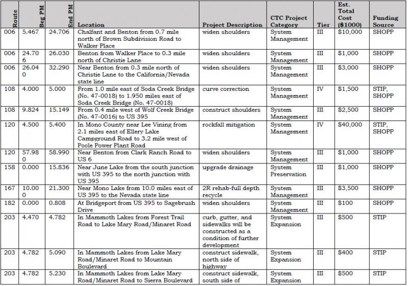
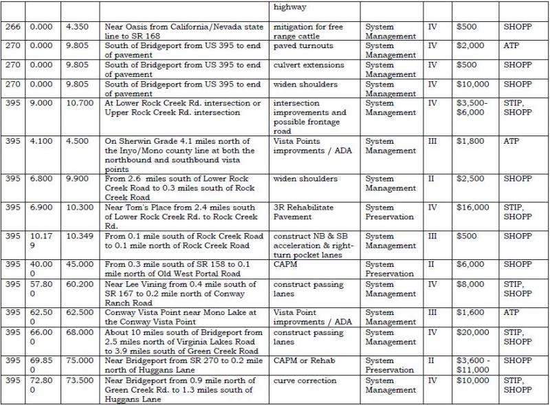
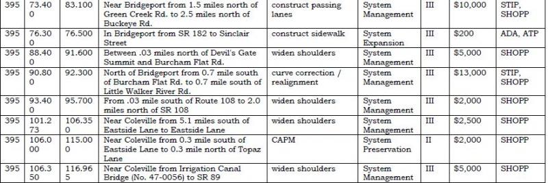
Shopp Projects
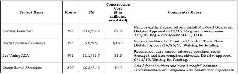
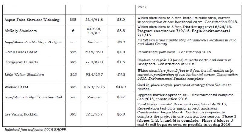
Long-Range Highway Improvement Program
Caltrans Interregional Improvement Program (IIP)*
The Mono County Local Transportation Commission supports Caltrans District 9’s IIP priority listing of projects. The following projects are ranked in order of priority and are needed to relieve congestion and improve the level of service on US 395.
![]()
* These projects should include various CMS, HAR, dynamic curve warning system, and other roadway applications in their scopes where appropriate.
Mono County Roadway Improvement Program
Mono County Short-Term Local Roadway Improvement Program
Mono County’s Short-Term Local Roadway Improvement Program focuses on road maintenance and rehabilitation. Projects will be prioritized based on the most effective use of resources. Pavement sections may not be resurfaced or rehabilitated based solely on PCI ratings. Instead, projects may be consolidated by community area and prioritized based on an assessment of the overall status of pavement within a community area. This approach will enable the County to minimize mobilization costs and maximize funding available for roadway rehabilitation.
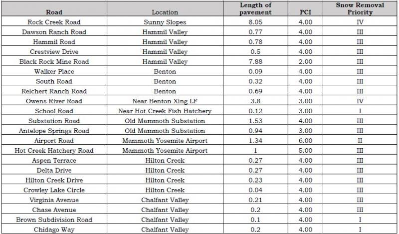
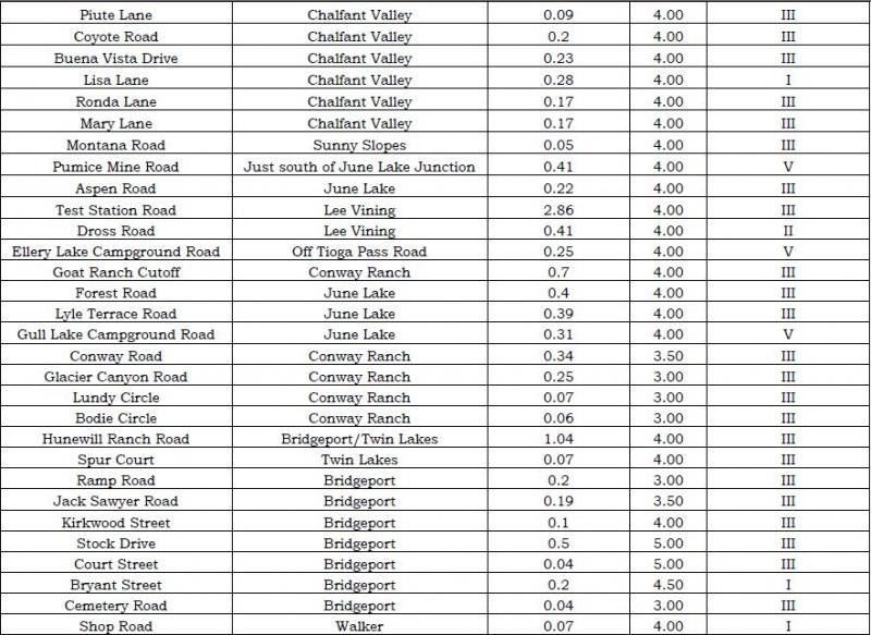
Mono County Long-Range Local Roadway Improvement Program
Mono County Long-Range Local Roadway Improvement Program
Road Rehabilitation ProjectsAirport Road (Lee Vining)
Airport Road/Hot Creek Hatchery Road
Antelope Springs Road
Benton Crossing Road
Buckeye Road
Cemetery Road
Convict Lake Road
Crowley Lake Drive
Cunningham Lane
Eastside Lane
Hackamore Lane
Hunewill Ranch Road
Lower Rock Creek Road
Lundy Canyon Road
McGee Creek Road
Mt. Morrison Road
Northshore Drive
Oil Plant Road
Owens Gorge Road
Owens River Road
Pit Road
Ramp Road
Rock Creek Road
Sawmill Road
Sherwin Creek Road
Substation Road
Swall Meadows Road
Test Station Road
Twin Lakes Road
Utility Road
Virginia Lakes Road
Yellow Jacket Road
Bridge Projects
Topaz Lane bridge repairs
Cunningham Lane bridge replacement
Bridge repairs & replacements as identified
Preventative Maintenance ProjectsCountywide projects as identified by the adopted PMS
Complete Street Projects
Bridgeport Pedestrian/Bicycle Improvements
Twin Lakes Road Bike Lanes
Lower Rock Creek Road bicycle climbing lane
Paradise trail system
Road Rehabilitation Projects by Community
Benton
Bridgeport
Chalfant
Coleville
Conway Ranch
Crowley Lake
Hammil Valley
June Lake
Lee Vining
Mono City
Paradise
Sunny Slopes
Swall Meadows
Topaz
Walker
White Mountain Estates
Main Street Revitalization Projects
June Lake (SR 158)
Lee Vining (SR 395)
Bridgeport (SR 395)
Miscellaneous Improvement ProjectsBridgeport wayfinding
Countywide transit stop improvements
Chalfant - Safe Routes to School bus stops
Countywide bike rack system
Fuel System upgrades
ITS upgrades - transit and emergency services
Public Works ITS monitoring program
Stabilization of cut slopes
Road Shop facility improvements
Road Shop site improvements
Safety upgrades - culverts, guard rail, signage, etc.
Class 1 Bike Path ProjectsBridgeport Trail System
Chalfant Loop Road
Lower Rock Creek Road to Tom's Place Connector
Mountain Gate Phase 3 trail
Owens Gorge Road to Benton Crossing Connector
Paradise trail system
New Road / Road Extension ProjectsBodie Road - construct last two miles to State Park
Lower Rock Creek Road to Crowley Lake Drive
Mono City Emergency Access Road
Owens Gorge Road to Benton Crossing
Petersen Tract Emergency Access Road
Swall Meadows Emergency Access Road
Town of Mammoth Lakes Roadway Improvement Program
Town of Mammoth Lakes Short-Term Local Roadway Improvement Program
Sherwin Creek Road Improvements
Sawmill Cutoff Road Improvements
West Airport Road Access
East Airport Access Road
Sierra Park Road Extension
Tavern Road Extension
Sierra Nevada Road Extension
Chateau Road Extension
Thompsons Way Extension
North Village Area Assessment District Street Work
OMR 3R Main Street to Minaret Rd
Forest Trail 4R
Meridian Blvd 3R SR 203 to Sierra Park Rd
Main St/Manzanita left turn lane
Main St/Mountain Blvd intersection improvements
Old Mammoth Rd/Sierra Nevada Rd intersections improvements
Azimuth/Meridian intersection improvements
Kelley/Lake Mary Road intersection improvements
Lakeview/Lake Mary intersection improvements
Westerly Majestic Pines/Meridian intersection improvements
Easterly Majestic Pines/Meridian intersection improvements
Minaret/Forest Trail intersection improvements
Minaret/Meridian intersection improvements
Minaret/OMR intersection improvements
Meridian/Sierra Park intersection improvements
Lake Mary Road/Canyon Blvd Signal Modifications
Meridian Blvd Project
Meridian Blvd Project
Waterford Avenue Crossing
Park and Ride Lots - Village, Main St, S. OMR, Airport
Pedestrian Crossing Improvements
Extend Main St. (SR 203) Turn Lane Manzanita to Minaret
Main St. (SR 203) Frontage Roads
Main St. (SR 203) Signal USPO and Mountain
Minaret/Main (SR 203) intersection improvements
Main (SR 203)/Center Street intersection improvements
Main (SR 203)/Forest Trail intersection improvements
Main (SR 203) Pedestrian and Safety Improvements (north side)
Main (SR 203) Pedestrian and Safety Improvements (south side)
Main (SR 203) Revitalization and safety Improvements
Complete Street Projects
Hillside Drive
Lake Mary Road
Laurel Mountain Road
Minaret Road
Chateau Road
Azimuth
Chaparral and extension
Lakeview Blvd
Lake Mary Loop Road
Miscellaneous Improvement Projects
Municipal Wayfinding
Townwide Transit Stop Improvements
Eastern Sierra Transit Authority facility expansion
Town Maintenance Yard Parking Barn
Welcome Center enhancements
Town Fueling Island upgrades
ITS Upgrades - Transit and Emergency Services
Public Works ITS Monitoring Program
Scenic Loop staging parking lots
Class 1 Bike Path Projects
Old Mammoth Road Mammoth Creek Park to Minaret Rd Gap
Waterford Gap
South Side Main St Callahan Way to Minaret
West Side Minaret Road
Sherwin Loop
Knolls Loop
Lake Mary Loop
Welcome Center Loop
Chair 15 Connector
Miscellaneous Connectors
Trail System Wayfinding
Mono County Airpport Improvement Program
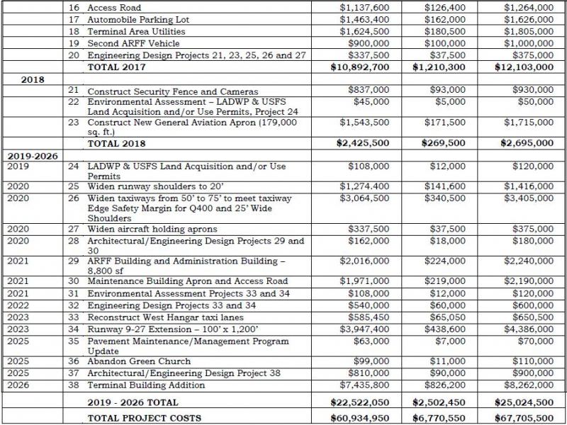
Mono County LTC Unconstrained Project List
Unprogrammed LTC Priorities: Tier 1
Chosen as a priority by three or more LTC commissioners
- Mono County community-based pavement rehabilitation projects
- N. Conway passing lane or four-lane project (approved MOU project in 2014)
- Realignment of Lower Rock Creek Road and US 395 intersection
- Mammoth Yosemite airport deer/snow safety fence
- US 395 deer/snow safety fence from Caltrans McGee Creek Maintenance Station to SR 203 and a portion of 203
- Countywide bridge plan / Topaz Lane bridge replacement (staff only, brought before Board)
- Southerly Airport Access Road construction (staff only, brought before Council)
- SR 203 Main Street signal project (staff only, brought before Council)
Projects of Interest: Tier 2
Chosen as a priority by two LTC commissioners
- Catch up with backlog of road striping on County roads to improve safety (also staff priority)
- Reinitiate US 395 N. Sherwin Grade improvement project
- Conway Summit cut: complete evaluation of slope stabilization trials and complete
- US 6 flood control issues (bridges, culverts)
- Tioga Pass Heritage Highway: safety & scenic/interpretive enhancements
- Add Mammoth as destination to mileage signs in Nevada and/or I-15
- Add northbound left turn lane at US 395 and Mill Canyon (north of Walker)
- Repainting and maintenance of Mono County entry signs on US 395
- Add Mammoth/Hwy 203 as destinations to US 6, SR 120, and Benton Crossing Road signs
Projects of Interest: Tier 3
Chosen as a priority by one LTC Commissioner and RPACs or County staff
- Add Bridgeport Twin Lakes Road shoulder and bike lanes
- Add SR 182 shoulder and bike lanes
- Develop trails system in Bridgeport – winter & summer
- Add Bridgeport welcome/gateway signs
- Add bike lanes and/or wider shoulders on major routes in Chalfant
- Expand Lee Vining/June Lake Main Street Revitalization & walkability
- Add bike path connecting Chalfant Loop Rd to Chalfant proper (1 mi) creating a safe bike route between White Mtn. Estates and Chalfant
- Bridgeport Main Street projects
- Bridgeport wayfinding tied to School St Plaza & County “campus”
- Bridgeport Main St sidewalk improvements: curb extensions, pedestrian furniture, landscaping and street trees, finish sidewalks
Projects of Interest: Tier 4
Chosen as a Priority by one LTC commissioner
- Designate SR 158 as State Scenic Highway
- Create a Transportation Asset Management Plan matrix for the Town
- Construct scenic pullouts on US 395 in Bridgeport Valley
- County Road Shop/Yard in Bridgeport: landscape/screen from US 395, add dark-sky compliant lighting
- Hwy 203 Main Street Revitalization
- Repair eroding slopes at Auchoberry Pit
- Renovate June Lake Loop rumble strip @ US 395 to be safer for bicyclists
- Screen old sheriff’s substation from US 395 with berm
- Utilize self-weathering steel guardrails in the county
- Add grooves cut across US 395 in varying widths to generate different sounds that “play” a song as cars pass over to prevent drivers falling asleep
- Add signage along US 395 to identify special geographic features
- Add right turn lane at McGee on southbound US 395
- Pave the last two miles of Bodie Road to the State Park
- Rehabilitate and stabilize cut slope above ballfield on Crowley Lake Drive
- Rehabilitate and stabilize slopes on Lower Rock Creek Rd
- Keep Crestview rest area open year round
- Reinitiate & complete deer fence/grade separate at Sonora Junction
- Work with Inyo LTC to designate all of US 395 as State Scenic Highway
Mono County Projected Transportation System Operating Costs
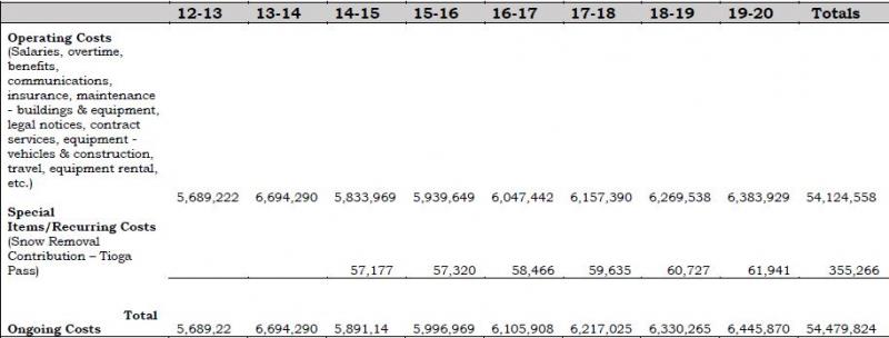
Fiscal Year 2012-13 is actual expenditures; FY 2013-14 is based on the current budget; remaining years are based on a 2% projected growth factor.
Contributions for snow removal on Tioga Pass are based on the average of actual contributions in 2010 and 2011, calculated with a 2% growth factor.
Town of Mammoth Lakes Projected Transportation System Operating Costs
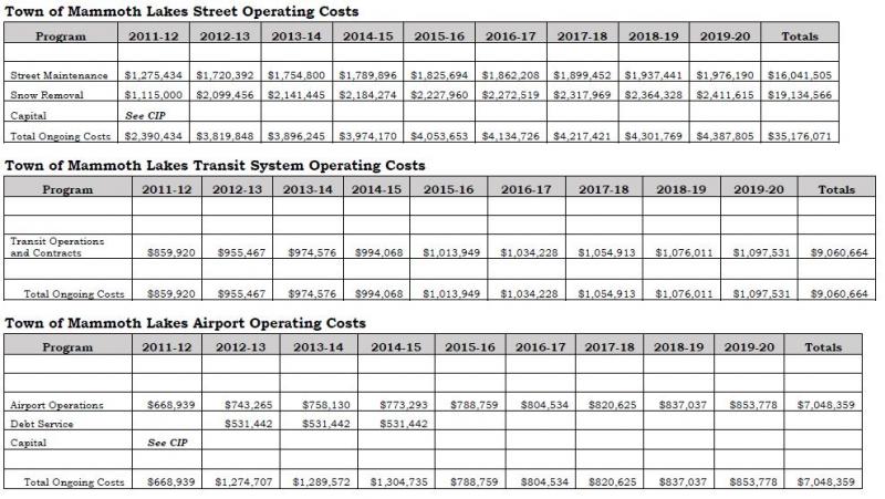
Fiscal Year 2012-13 is actual expenditures; FY 2013-14 is based on the current budget; remaining years are based on a 2% projected growth factor.
Mono County Revenue Projections
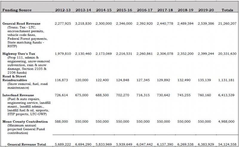
Town of Mammoth Lakes Revenue Projections
Town of Mammoth Lakes Streets Revenue Projections
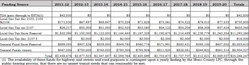
Fiscal Year 2012-13 is actual revenues; FY 2013-14 is based on the current budget; remaining years are based on a 2% projected growth factor.
Town of Mammoth Lakes Transit System Revenue Projections
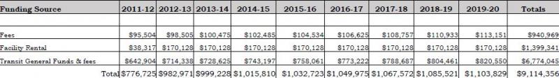
Fiscal Year 2012-13 is actual revenues; FY 2013-14 is based on the current budget; remaining years are based on a 2% projected growth factor.
Town of Mammoth Lakes Airport Revenue Projections
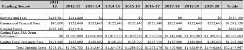
Fiscal Year 2012-13 is actual revenues; FY 2013-14 is based on the current budget; remaining years are based on a 2% projected growth factor.
This map is available online at http://monocounty.ca.gov/sites/default/files/fileattachments/public_work... or by calling the Public Works Department at 760.932.5440.
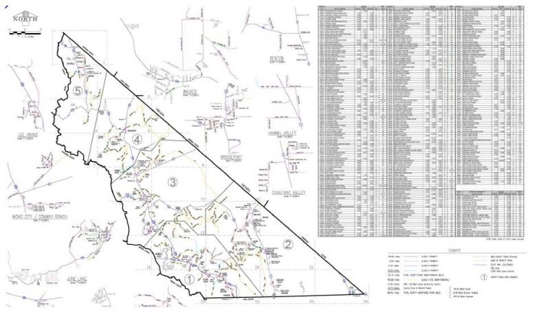
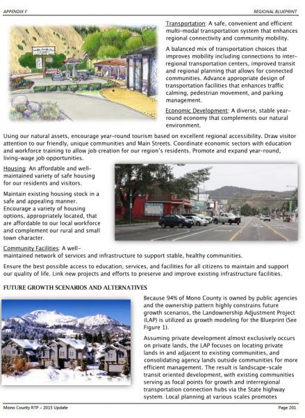
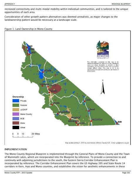
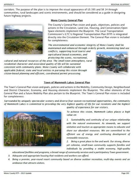
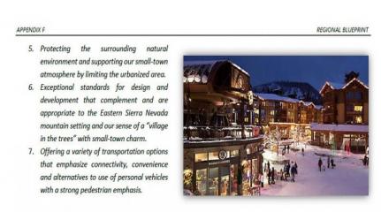
Table of Contents
II. Existing Trails Systems and Policies.
IV. Issues, Opportunities, and Constraints by Planning Area.
VI. Regional and Community Routes.
I. Purpose of Plan
The overall purpose of the Mono County Trails Plan is to establish trail systems that facilitate multi-modal travel and recreation within, around and between unincorporated communities in the county. The Plan addresses regional routes that provide access to communities throughout the county and to major recreational areas and existing trail systems, and community routes that provide access throughout communities and to surrounding recreational areas.
The Trails Plan is intended to expand upon and implement policies in the Mono County General Plan, associated Area Plans, the Mono County Regional Transportation Plan, and to coordinate with the applicable plans of federal land management agencies. The Plan focuses primarily on the development of facilities for recreational users, both residents and visitors.
Specific purposes of the Plan are to inventory existing trail systems in the county and to provide a concise summary of those systems, to evaluate the needs of the County’s communities for new local community routes and the possibility of linking existing routes, to designate routes and prioritize their development, and to delineate policies for the future development of trails systems in the county.
II. Existing Trails Systems and Policies
Inventory of Existing Trails Systems
Trail:- A track made by passage, especially through a wilderness.
- A marked path through a forest or mountainous region.
- A course followed or to be followed.
The term “trail” can encompass a wide variety of uses when it is defined as a course to be followed. Trails in Mono County, with its many recreational resources, include wilderness trails used by hikers and equestrian users, dirt roads used by off-highway vehicles and equestrian users, signed trails for Nordic skiing and snowmobile use, scenic byways used as sightseeing trails, hiking trails at developed recreation sites, and roadways used by both mountain bikers and touring bicyclists. Trails serve two purposes – recreational experience for those who travel along them and as link between different areas of the county.
Since so much of the land in the county is publicly owned (approximately 94%), most of the existing trail systems in the county are on public lands and are managed by either the U.S. Forest Service (USFS) or the Bureau of Land Management (BLM). The California State Park units in the county, Bodie State Historic Park and Mono Lake Tufa State Reserve, contain internal trails systems used by visitors to the parks. The highway system in Mono County also functions as a trail system, primarily for motorists and bicyclists.
USFS/Inyo National Forest and USFS/Humboldt-Toiyabe National Forest Trails
Lands administered by the USFS in Mono County contain extensive trails systems ranging from backcountry wilderness trails to paved recreational trails in concentrated recreation areas. The Land and Resource Management Plans for both the Inyo National Forest and Humboldt-Toiyabe National Forest contain policy direction for trails and roadways for each of the land management areas in the forests. In addition, the Forests have developed specific plans and resources for different types of uses, such as the Humboldt-Toiyabe Bridgeport Winter Recreation Area Plan and the Interagency Off-Highway Vehicle Trail Maps by the Inyo National Forest and the BLM.
Public lands administered by the USFS run the entire length of the county on its western border, running east to US Highway 395 and in some cases, farther. These are the most heavily used and developed Forest lands, with more concentrated recreational areas and facilities adjacent to communities or major recreation areas such as June Mountain Ski Area and the June Lake Loop. Other Forest lands in the eastern part of the county are less developed and have fewer users.
The corridor from Mammoth Lakes to June Lake is one of the most heavily used in the southern portion of the county, while the Twin Lakes and Sonora Pass areas are popular in the northern portion of the county. National Forests have many developed recreational facilities, including campgrounds, picnic areas, trail heads, and signed trails for hiking, biking, equestrian, snowmobile, and Nordic ski use.
Maps of trail systems on the forests are available from district ranger stations and visitor centers. In addition, a number of specialized maps have been developed showing cross country ski trails, snowmobile routes, and mountain bike routes, particularly for the heavily used area between Mammoth Lakes and June Lake. The Interagency OHV maps provide detailed mapping of roads for the Inyo National Forest.
Bureau of Land Management Trails
Public lands administered by the BLM in Mono County do not generally contain developed trails systems. They do contain an extensive system of dirt roads used by hunters, anglers, equestrians, OHV users, and others wishing to explore the more arid sagebrush scrub and pinyon-juniper communities found on BLM lands in the county. Generally, marked roads are major routes between various areas in the county, such as the roads leading from US Highway 6 in the Tri-Valley area to the Crowley Lake area.
The BLM Resource Management Plan contains policy direction for trails and roadways. The BLM has also developed the North of Bishop Vehicle Access Strategy Plan for the Bodie Hills and for the lands it manages in the Bridgeport Valley and Antelope Valley areas. The overall intent of the BLM is to maintain semi-primitive conditions on the lands it manages and not to develop facilities on those lands.
California Department of Parks and Recreation Trails
The California Department of Parks and Recreation updated Recreational Trails Plan in 2002. The Plan focuses on….: Bicycling; Boating; Off-Road Vehicle Use; and Hiking and Equestrian Use. Each element describes existing conditions, states goals and objectives, and identifies recommended projects. Projects are recommended in areas of high demand, generally near urban areas. The Plan contains useful information concerning trail system development, including design standards and guidelines. There are no proposed state trail systems in Mono County, although each of the county’s State Park units, Bodie State Historic Park, and Mono Lake Tufa State Reserve, contains internal trail systems. Trails within the Bodie State Historic Park are addressed within the Bodie State Historic Park Resource Management Plan.
Town of Mammoth Lakes: “Mammoth Lakes Trail System”
The “Mammoth Lakes Trail System” is a partnered effort of the Town of Mammoth Lakes and the US Forest Service to implement the Town’s 2011 “Trail System Master Plan.” The Town and the US Forest Service have executed several agreements to facilitate the effort, and the citizens of Mammoth Lakes have approved funding resources for implementation through Measures “R” and “U”. The Town has contracted with Mammoth Lakes Recreation, a community benefit non-profit corporation established by the Town, to provide oversight for the Mammoth Lakes Trail System program and the Town has hired a full time Trails Coordinator. The primary uses of the proposed multi-use trail system are described on the “Activities” section of the Mammoth Lakes Trail System website at mammothtrails.org. Trails identified in the Plan as “Future/Alternative Trails” would connect trails and bikeways within the more-developed area of the town to trails in the adjacent unincorporated area. Please contact the Town’s Trails Coordinator for more information on the Town’s “Trail System Master Plan” and the Mammoth Lakes Trail System.
Sightseeing Trails – Scenic Byways
Sightseeing is a major recreational activity in Mono County that occurs primarily along the highways. US Highway 395 (US 395) through the county, State Route 120 (SR 120) in Lee Vining Canyon, State Route 158 (SR 158) in the June Lake Loop, and State Route 270 (SR 270) to Bodie are heavily used for sightseeing and touring.
A major portion of US 395 is a state-designated scenic highway. SR 120 in Lee Vining Canyon is a National Forest Scenic Byway, and the Forest Plans and BLM Plan recommend scenic byway designations for several other roadways in the county. The Coalition for Unified Recreation in the Eastern Sierra (CURES) has made interpretive improvements along the scenic highway/byway 395 corridor in Mono County, including development of kiosks and informational materials along US 395 and SR 120 (Lee Vining Canyon) to enhance the sightseeing experience.
Visitors to the county would benefit from similar facilities along other local roadways, particularly along SR 158 (June Lake Loop), and SR 270 to Bodie, both of which are heavily used for sightseeing.
Off-Highway Vehicle Trails
An extensive system of off-highway vehicle trails exists in the county, as discussed in the previous section on BLM trails. The BLM and USFS management goals for these routes are to maintain the existing semi-primitive recreational experience by providing a predominantly natural environment. The roads will remain dirt; there will be no developed facilities except for road signs on major routes and a few informational kiosks. The BLM and USFS have developed a “Tread Lightly” educational program for OHV users, similar to the program for wilderness users.
Outside the highway system, the County’s dirt-road system may be the most heavily used existing trail system. Not only are the roads used to provide access to recreational areas, they are also used as recreational experiences themselves, to provide access to resources such as firewood and as alternate access routes between different parts of the county.
Pedestrian Trails
Pedestrian hiking trails are largely limited to backcountry trails on forest lands. In communities, pedestrian activities occur along streets and in some communities on limited sidewalk systems. Outside communities, hiking occurs on the extensive dirt road system and on public lands. The interest for additional pedestrian facilities outside community areas is growing and several communities are pursuing additional pedestrian facilities and related streetscape improvements.
Nordic Ski Trails
There are marked Nordic ski trails at Smokey Bear Flat, near Mammoth, in the Deadman Summit area, and within June Lake. Nordic skiing also occurs on public lands in unmarked areas. Existing trails generally are not adjacent to communities in the county; there is some potential for additional trails near communities.
Snowmobile Trails
There are marked snowmobile trails at Smokey Bear Flat, near Mammoth, in the Deadman Summit area, and near June Lake. Snowmobile use also occurs on public lands in unmarked areas. Marked trails are often the result of cooperative efforts among the USFS, snowmobile enthusiast groups, and local snowmobile rental operators. Snowmobile use does occur on a limited basis immediately adjacent to community areas.
Equestrian Trails
Equestrian use occurs along existing roads and trails or along trails on public lands that are also used by hikers and bicyclists. Presently, there is concern from equestrian users over the sharing of trails with bicyclists. This issue needs to be resolved by all trail users. Equestrian users often trailer their horses to trail heads, or parking areas outside their communities. Visitors may use the services of an outfitter or a pack station.
Mono County General Plan Policies
The Mono County General Plan, updated in 2015, contains policies relating to trails and recreation in both the Circulation Element and the Conservation/Open Space Element. The General Plan Circulation element also includes trail systems maps and route descriptions for a trail system in the county.
Mono County Regional Transportation Plan Policies
The 2015 update of the Mono County Regional Transportation Plan contains the same policies and the same trail maps as the 2015 update of the county General Plan Circulation Element.
III. Community Trails
Issues, Opportunities, and Constraints
The following section addresses pertinent issues, opportunities, and constraints, including those identified in the Circulation Element of the General Plan and in the Regional Transportation Plan. Bikeways are discussed in the Bicycle Transportation Plan.
Demand for TrailsAs the previous chapter noted, Mono County has numerous trails and roadways that provide various recreational experiences for visitors and residents. Regional routes, which are mostly roadways, provide accessibility to most areas of the county and to recreational areas. The system is fairly well established and consists of the highway system and dirt roads on public lands.
Community routes are less well established. Opportunities exist to develop new trails and to expand existing informal trails in community areas, and to provide trails that link community and recreational areas and facilities. Many community routes remain undeveloped.
In community areas, the primary need is for pedestrian and bike trails. Demand for other types of trail is limited and is often provided by facilities on public lands outside community areas. There is a potential, however, to create multiple-use trails. The seasonal nature of recreation in Mono County creates a need for different types of trails at different times of year. Trails providing pedestrian, biking, and equestrian opportunities in the summer work equally well as Nordic ski facilities in the winter.
Trails are in greater demand in certain communities than in others. Communities with concentrated recreational use and heavy visitation have a greater need for facilities than communities that are primarily residential in nature and that receive little recreational use.
Scenic Byways and TrailsSightseeing along roadways is a major recreational activity with a number of scenic routes in Mono County. Scenic route designations include State Scenic Highways 395 and 89, Scenic Byways along SR 120 and US 395, and a number of other roads designated as County scenic highways. The Mono County Master Environmental Assessment provides a comprehensive overview of designated scenic routes within the region.
Off-Highway Vehicle TrailsOff-highway vehicle facilities include the existing system of roads and trails on public lands. The BLM’s and USFS’s management plans for those lands adequately address management needs, primarily the signing of major routes and public education concerning the need to tread lightly.
Because the road system is so extensive, it is easily accessible from points throughout the county, including community areas. Major access points are signed, and maps are available from the BLM and USFS showing those routes.
Pedestrian TrailsTwo types of pedestrian trails exist in or adjacent to Mono County communities, sidewalks and walking/hiking trails or paths. Some communities have sidewalks, but no community has extensive pedestrian facilities. The County has no active program for striping or marking pedestrian facilities, nor has it been a major concern of Caltrans in the past. With increased recreational use, particularly in community areas during peak season, the need for markings and traffic direction for pedestrians is increasing in some communities.
Additional pedestrian improvements are needed in most communities. There is also a need to improve existing routes used by pedestrians, such as widening the shoulder on roadways or providing an alternate pedestrian route. Pedestrian improvements would benefit communities in several ways; i.e., facilitating links between transportation modes, economic development benefits resulting from more-active commercial areas, increased livability of communities and increased safety resulting from elimination of the pedestrian/vehicle conflict in winter.
Trail-side Facilities
Trail-side facilities can improve the user’s enjoyment and understanding of the land and resources adjacent to and visible from a trail. Such facilities may include restrooms, drinking water, benches, picnic areas, parking areas for larger vehicles with horse trailers, and interpretive and way-finding signs. Trail-side facilities are most appropriate for developed trail systems, such as scenic byways and nature/interpretive trails, or at entrance points to less-developed trail systems, such as trail heads or major access roads to off-highway vehicle roads.
Public lands in Mono County contain a variety of trail-side facilities, including campgrounds, trail heads, picnic areas, and information kiosks. Trail-side facilities in community areas may include restrooms, benches, picnic areas, way-finding and interpretive signs, all typically concentrated in a rest area or park. Pedestrian amenities may also include improved lighting, landscaping paving, street furnishings (benches, drinking fountains, trash receptacles), improved street crossing, and improved access to parking areas.
Design StandardsSince Mono County has numerous trails and roads that range from somewhat rugged to extremely difficult, community trails should focus on providing accessibility for everyone. Trail-side facilities developed in conjunction with new or existing trails should be designed to be accessible to persons with disabilities.
Since the focus of many trails and roads in Mono County is the scenic beauty of the surrounding environment, trails and associated facilities need to blend into that environment to the greatest extent possible. Similarly, in community areas trails and facilities need to be designed and constructed to complement the existing setting.
Environmental concerns regarding the construction of trails are addressed by the USFS Standard Trail Plans and Specifications. Design considerations for accessibility are addressed by the Americans with Disabilities Act and the California Building Code.
A primary consideration in the design and construction of trails and facilities is the ongoing maintenance of those facilities. Facilities should be designed to be low maintenance and long-lasting. Cooperative maintenance should include all user organizations; i.e., hikers, bikers, and equestrians.
IV. Issues, Opportunities, and Constraints by Planning Area
Antelope Valley
- Recreation destinations in the area include Topaz Lake and the West Walker River. At Topaz Lake there is the potential to provide increased recreational opportunities, including hiking trails, rest areas, picnic areas, etc. The Walker River Irrigation District (WRID) manages the lake and owns much of the property surrounding the lake.
- There is also the potential to develop public access trails to the West Walker River throughout the Valley. This would require cooperating with the WRID and private landowners who own most of the land in the valley adjacent to the river.
- Off-Highway Vehicle (OHV) use in the Antelope Valley occurs primarily on surrounding public lands.
- There is an opportunity to enhance sightseeing in the Antelope Valley and to promote Walker as a gateway community to the Scenic Byway south of Walker.
Sonora Junction/Devil’s Gate/Swauger Creek
- The Devil’s Gate to the Swauger Creek area is an isolated residential area with limited year-round occupancy. Private parcels in the area are surrounded by public lands that provide recreational opportunities for residents.
- Sonora Junction area includes river access, campgrounds, a pack station and associated trails generally located on public land.
Bridgeport Valley
- Major recreational destinations in the Bridgeport Valley include Bridgeport Reservoir and Twin Lakes. A bicycle route to Twin Lakes from Bridgeport, and to the state line on SR 182, is discussed in the Bicycle Transportation Plan and Regional Transportation Plan. The historic building tour included in town, staged from the Bridgeport Park next to the museum, is part of the Eastern Sierra Scenic Byway.
- There is a need to enhance pedestrian facilities along US 395 from the Evans Tract to town, and along SR 182 from town to the residential areas along the reservoir. Residents, especially children, currently must walk along the highways.
- OHV use in the Bridgeport Valley occurs on surrounding public lands. The BLM’s North of Bishop Vehicle Access Strategy Plan addresses management of OHV activity on those lands.
- Interest is high in creating a multi-use year-round trail system in the Valley that would function as bicycling, pedestrian, and/or equestrian trails in summer and Nordic skiing trails in winter. This would be particularly feasible on Timber Harvest Road and on a route between Timber Harvest Road and town.
Bodie
- The Bodie Bowl area is both a State Historic Park and National Historic Landmark. The remoteness of Bodie provides excellent opportunities for enjoyment of this historic ghost town and its scenic backdrop; and is a major recreational attraction for Mono County. Alternative modes of transportation are encouraged in the Bodie Bowl Area of Critical Environmental Concern (ACEC) and Bodie Hills Planning Area Cooperative Management Plan.
- The Bodie Bowl ACEC and Bodie Hills Planning Cooperative Management Plan, Bodie State historic Park Management Plan, and supporting BLM planning documents provide direction for pedestrian, bicycle and/or equestrian trails access into Bodie. Existing trails, rather than new trails, are to access the area whenever practical.
Virginia Lakes
- The Virginia Lakes area is heavily used by seasonal residents and visitors. A number of trails and roads exist in the area. Pedestrian and bike facilities should be considered during any roadway improvements in the area.
Mono Basin
- The Mono Basin is a heavily used recreational destination. A number of existing trails and roads lie within the boundaries of the Mono Basin National Forest Scenic Area. The Scenic Area’s Comprehensive Management Plan governs use of those facilities.
- The Mono Basin has two communities: Lee Vining and Mono City. Pedestrian facilities in Lee Vining could be improved by streetscape improvements along US 395 right of way and by the provision of additional parking. The Mono Yosemite Trail Plan also identifies opportunity to connect Mono City to Lee Vining with trail access.
- Opportunity exists to extend the Lee Vining Creek trail up Lee Vining Canyon to the campgrounds and other locations as specified in the Mono Yosemite Trail Plan.
- Access for pedestrians and equestrians along the west side of Mono Lake is limited to the shoulder of US 395 or to trails on the steep hillside to the west. Residents have expressed concern that access be improved along this portion of the highway.
June Lake Loop
- The June Lake Loop is a heavily visited recreational destination that experiences occasional traffic congestion. The Village area, in particular, lacks adequate parking and pedestrian facilities.
- The June Lake Area Plan, part of the county General Plan, contains policies that stress the need to develop a trail system linking commercial, residential, recreational, and parking nodes. This trail system should be designed and implemented to provide year-round recreational and commuting opportunities consistent with the June Lake Loop Trail Plan/Map.
- The June Lake Loop Trail Plan/Map recognizes potential exists to develop trails to the Village and to surrounding recreational areas within the June Lake Loop.
- Northshore Drive and the Rodeo Grounds/West Village area provide opportunity for trails to access the June Lake ball field, the June Mountain Ski Area, and Gull and June lakes.
- The June Lake Trail Committee meets regularly, conducts fundraising, sponsors an annual Trails Day, and oversees implementation and updates of the Trail Plan.
Mammoth Vicinity/Upper Owens
- Recreation is the principal use of this area; much of it occurs on the extensive road system in the area and on marked Nordic ski trails and snowmobile trails. The USFS and BLM resource management plans and other planning documents address management of these facilities.
- Pedestrian use of Substation Road is extensive and occurs on a year-round basis. On much of the road, shoulders are not adequate to allow pedestrians to get off the roadway. People walking on the road, or in the surrounding hills, park off the road in several areas. There is potential to develop a parking area, picnic area, visitor kiosk, and interpretive site in the vicinity. Interpretive facilities/trail related to the Casa Diablo resource area is anticipated and would contribute to the Highway 395 Scenic Byway corridor.
- The Town of Mammoth Lakes has a planned trail system within the town’s boundaries. Connecting this trail system to trails in the surrounding unincorporated area would create additional opportunities for users of the Town’s system. The Whitmore Track area is used as a staging and training area for high- altitude long-distance running.
Long Valley
- Crowley Lake Drive provides access to several recreational areas in nearby Sierra Nevada canyons and is also a popular recreational route itself. Pedestrians and bicyclists use it for local rides or as a portion of longer tours. Pedestrian safety is a concern of local residents, particularly along Crowley Lake Drive and South Landing Road.
- Benton Crossing Road is popular for pedestrian use as well as bicycling. Shoulders on the road have been improved for bicycling and running use.
- Concepts have been discussed to develop a hiking, cycling, and equestrian trail around Crowley Lake if demand warranted such a trail. Various roads and trails, which could be linked to provide access, now exist most of the way around the lake. Since the Los Angeles Department of Water and Power owns much of the land around the lake, a trail system would require its cooperation.
- Opportunities exist for other regional trails in the long valley area, including a trail connecting the Mammoth area with Long Valley via use of existing roads. Better signage and completion of a small portion of trail near Tobacco Flat would be necessary. Currently, an unofficial parking area exists at the northern end of Crowley Lake Drive and US 395. This area could be improved to provide better access for all trail users.
- Additional trails between Long Valley and Tri-Valley provide access along Benton Crossing Road to the glass Mountains, Casa Diablo hills, volcanic tablelands, and the Owens Gorge.
Wheeler Crest/Paradise
- Wheeler Crest/Paradise is a residential area with limited demand for pedestrian or equestrian trails. Residents currently use the existing road system and surrounding public lands for a variety of trail and recreational activities. Lower Rock Creek Trail and Lower Rock Creek Road are a recreational destination for visitors and bicyclists.
Tri-Valley
- The Tri-Valley area includes three residential communities with limited commercial facilities that receive limited recreational use. Demand for pedestrian or equestrian facilities is growing.
- US Highway 6 (US 6) through the region lacks turnouts or rest-area facilities for sightseers. Paved turnouts with interpretive signing would enhance travelers’ enjoyment of the road.
Oasis
- Oasis is an isolated agricultural area with little recreational use and limited demand for trails.
V. Policies
The following section contains new policies as well as pertinent policies from the Circulation Element of the General Plan and the Regional Transportation Plan.
Goals
- Develop a cohesive regional and community trail system that provides access to all communities and to major recreational areas.
- Work with communities in order to gain consensus on current and future trail improvements and priorities.
General Development Standards
Policy 1. Where possible, utilize existing roads and trails to develop the trail system in Mono County.
Policy 2. Work with appropriate agencies to develop trails and associated facilities that connect to existing trail systems.
Policy 3. When possible, plan and develop trails as multi-use year-round facilities.
Policy 4. Concentrate developed trails and facilities in the most heavily used areas such as in and around communities.
Policy 5. Development of trails on County roads and private property should be consistent with goals and policies for trails development and recreational use on adjacent public lands.
Policy 5a. Encourage agencies to manage OHV use on public lands to minimize user conflicts.
Policy 6. Provide input to federal and state agencies on the development of trail systems on public lands, particularly in areas adjacent to communities.
Policy 7. Design trails to limit impacts to sensitive plant communities including wetland and riparian corridors.
Policy 8. Incorporate signage into trail design to encourage compliance with trails rules and etiquette.
Community Trails
Policy 9. Utilize community trails to connect commercial, employment centers, community facilities, recreational, and residential areas in communities, and to link communities to surrounding trail systems and recreational areas.
Policy 10. Community trails should include way-finding and informational signage to facilitate their use.
Policy 11. Where feasible, and where demand warrants, design and construct community trails as multi-use facilities and as year-round trails.
Policy 12. Seek funding for the development and maintenance of community trails.
Policy 13. Work with subdividers to provide connecting paths to existing local and/or community, educational, and recreational facilities.
Policy 14. Work with community groups to refine and implement the conceptual trail schemes presented in this Plan and supporting documents.
Policy 15. Promote healthy lifestyles by integrating trails into communities. At the community level, connect neighborhoods, community facilities, and main streets via trail systems. At the regional level, connect communities to scenic resources, appropriate historical/cultural places, and recreation opportunities, as well as to other communities.
Policy 16. Reference and update existing community trail documents in establishing trail priorities.
Policy 17. Investigate the feasibility of improving connections of the regional OHV network with supportive communities, such as combined use designations for County roads in northern Mono County.
Design Standards
Policy 18. Trails shall be developed and maintained in conformance with the USFS’s Standard Trails Plans and Specifications.
Policy 19. Trails shall be designed for accessibility in accordance with the Americans with Disabilities Act and the California Building Code.
Policy 20. Work with communities, Caltrans, USFS, BLM, and other agencies to develop and implement a standardized way-finding program.
Policy 21. Pursue common standards for the region, particularly in the design of signage and wayfinding, marketing, and information systems such as data sets and maps.
Policy 22. Trailside facilities shall be designed and constructed to blend with the surrounding natural environment and be designed for low maintenance.
Policy 23. Parking facilities shall be sited, designed and constructed to minimize potential visual and water quality/drainage impacts.
Trail-Side Facilities
Policy 24. Trail-side facilities should be developed in the most-heavily-used areas, particularly on community trails.
Policy 25. Trail-side facilities should provide the following amenities, as appropriate and financially feasible:
- Rest areas, including restrooms and drinking water;
- Picnic areas;
- Parking areas and where appropriate, adequate facilities for horseback riders; and
- Interpretive signs/kiosks.
Policy 26. When planning trail-side facilities, particularly in community areas, consideration should be given to what other facilities are available in the area in order to avoid duplication of services and to provide the most-complete array of facilities.
Policy 27. In accordance with applicable laws, trail-side facilities shall be designed for persons with disabilities.
Policy 28. The need for pedestrian amenities along sidewalks, such as improved lighting, landscaping, paving, street furnishings (benches, drinking fountains, trash receptacles), winter maintenance requirements, improved street crossings, and improved access to parking areas should be evaluated when designing improvements to sidewalk systems.
Policy 29. Seek funding to develop additional trail-side facilities and amenities (such as information kiosks) along regional and community trails.
Policy 30. Work with community groups, special districts, and businesses to sponsor development and maintenance of trail-side facilities in community areas.
Trails Funding
Policy 31. Fiscal analyses for proposed trails development projects should consider both construction and maintenance costs.
Policy 32. Funding efforts should focus on developing community trails and associated facilities. Within communities, focus funding efforts on proposed trails where demand is highest.
Policy 33. Countywide priorities for trails development should be established in the Capital Improvement Plan (CIP) for Mono County.
Policy 34. Develop a strategic plan in consultation with federal, state, and local agencies for coordinating and applying for trails funding.
Policy 35. The County shall include applicable trails development projects identified in this Plan in its CIP once funding has been secured.
Policy 36. Revise funding priorities periodically to reflect changes in funding availability and local and regional needs.
Policy 37. Consider developing and implementing a sponsorship program where local businesses and community groups contribute to the construction and maintenance of trail-side facilities with community areas (e.g., similar to Caltrans Adopt-a-Highway or TOML Adopt-a-Trail).
Policy 38. Format and adjust planning documents/processes to qualify for new funding opportunities, such as the Active Transportation Program (ATP).
Policy 39. Pursue sustainable financial resources for trails development and maintenance. Support citizen stewardship and partnerships, and leverage the capacities of non-profits to assist in all aspects.
Cooperative Trails Development
Policy 40. Use partnerships in the planning, design, development, construction and maintenance of sustainable regional and community trail systems for all users.
Policy 41. Utilize established community-based and interagency planning forums/systems, such as RPACs, JLCAC, and the CPT to secure citizen and agency/entity involvement throughout the trail planning and development process.
Policy 42. Work with community groups and/or non-profits on the development and maintenance of trails and associated facilities.
Policy 43. Work with appropriate agencies and organizations to obtain funding for trails development.
Policy 44. Establish common standards for the region, particularly in the design of signage and wayfinding, marketing, and information systems such as data sets and maps.
Policy 45. Facilitate collaboration with agencies/entities in the funding, environmental review, planning and development of trails in communities and throughout the region. Collaborating entities should include Mono County, Mono County LTC, the Town of Mammoth Lakes, USFS (Humboldt-Toiyabe and Inyo), BLM, National Park Service, State Parks, Caltrans, LADWP, Walker River Irrigation District, Cal Fire, local fire protection districts, tribal entities, non-profits such as Friends of the Inyo, Mammoth Lakes Recreation, Mammoth Lakes Trails and Public Access, and Eastern Sierra Land Trust, and willing private partners, including ranchers.
Policy 46. Integrate trail opportunities into regional initiatives, such as watershed assessments, scenic byway programs, and corridor planning.
Community Priorities for Trail Development
Community priorities focus on those projects with the highest need.
Antelope ValleyPriority 1. Enhance pedestrian facilities along US 395 in Walker consistent with the Design Guidelines and Character Inventory study.
Priority 2. Work with the Walker River Irrigation District (WRID) to provide recreational facilities at Topaz Lake, including a hiking trail around the lake and interpretive facilities.
Priority 3. Work with WRID and local landowners to develop public access trails to the West Walker River, along with parking facilities, and informational signing.
Bridgeport ValleyPriority 1. Increase pedestrian safety from Evans Tract to town and along SR 182 from the reservoir to town.
Priority 2. Work with public land managers to create a multi-use, year-round trails system for pedestrians, bicyclists and equestrians in the summer, and nordic activities in the winter. Explore a potential trail connection between Timber Harvest Road and town.
Priority 3. Explore Off-Highway Vehicle recreation opportunities, such as combined use roads, while remaining sensitive to resource impacts and public concerns.
BodiePriority 1. Provide alternate access into Bodie with trails. Promote the use of unique and historical compatible modes of travel to Bodie, such as rail, horse-drawn wagons and carriages, and equestrian.
Priority 2. Support preservation of the old railroad grade from Mono Mills to Bodie. Highlight and interpret the old railroad grade as a trail route to Bodie.
Priority 3. Provide for wagons and similar historically compatible travel modes to Bodie through concession agreements and designation of routes.
Priority 4. Inventory existing trails in the Bodie Hills. Request State Parks to inventory trails with the Historic Park.
Priority 5. Prioritize trail development / improvement projects in this plan to expedite applications for grant funding.
Priority 6. Coordinate trail development with other modes of travel: provide trail linkages to the visitor center, parking areas, transit hubs and recreation nodes.
Priority 7. Consider winter use for appropriate trails. Designate applicable trails available for Nordic ski, snowshoe and snowmobile use.
Virginia LakesPriority 1. Any roadway improvements should include shoulder improvements for pedestrian use.
Priority 2. Encourage and work with appropriate agencies to maintain Sno-Park site just west of US 395 on Virginia Lakes Road.
Mono BasinPriority 1. Work with community groups to improve the sidewalk system along Main Street (US 395) in Lee Vining.
Priority 2. Work with the USFS, community groups, and landowners to implement an extension of the community trail up Lee Vining Canyon and to provide interpretive signage along the trail per the Mono Yosemite Trail Plan.
Priority 3. Work with Caltrans to improve safety for sightseers, pedestrians, and bicyclists on US 395 along the west side of Mono Lake.
Priority 4. Investigate potential alignments for trail connections between Mono City and Lee Vining.
June Lake LoopPriority 1. Continue to work with the June Lake Trails committee to implement the objectives of the June Lake Loop Trail Plan/Map.
Priority 2. Work with the USFS and private landowners to develop a trail connection between the June Lake Village and the Down Canyon area.
Priority 3. Work with Caltrans to enhance public safety by optimizing conditions for road bike and pedestrian users on SR 158. Identify areas for potential crossings/traffic calming solutions.
Priority 4. Maximize trail connections between existing establishments such as Gull Lake - June Lake, campgrounds – village, commercial areas and future developments (see Design Guideline and Character Inventory Study).
Priority 5. Identify missing links between existing trails for continued connectivity throughout the loop.
Priority 6. Implement a signage and way-finding program to better identify existing trails.
Mammoth Vicinity/Upper OwensPriority 1. Improve Substation Road area for pedestrian use.
Priority 2. Link the Town’s trail system to the surrounding unincorporated area, particularly on Sherwin Creek Road and the Scenic Loop Road.
Priority 3. Pursue an interpretive site and supporting facilities in the Substation Road vicinity such as a Geothermal Interpretive Trail.
Long ValleyPriority 1. Identify, formalize and utilize existing trails and pathways for connectivity within and between communities.
Priority 2. Support efforts to connect Lower Rock Creek Road so that it does not intersect with US 395 south of Tom's Place but terminates at Crowley Lake Drive south of Tom's Place.
Priority 3. Complete segment of regional trail (at Tobacco Flat) from the Mammoth Vicinity to Long Valley.
Priority 4. Study the feasibility of developing hiking, biking, and equestrian trails around Crowley Lake.
Policy 5. Explore inexpensive and low-maintenance traffic-calming strategies such as driver feedback signs and striping for bike/pedestrian lanes on County roads.
Wheeler Crest/ParadisePriority 1. Continue current efforts to provide additional pedestrian facilities along Lower Creek Road.
Tri-ValleyPriority 1. Work with Caltrans to provide improved crossing safety on US 6 between West Chalfant and the community center.
VI. Regional and Community Routes
Route selection was based on the policies in this chapter, on information in the Issues, Opportunities, and Constraints section of this chapter, as well as maps and data contained in the county General Plan and the Regional Transportation Plan, and the planning documents of other resource management agencies.
Regional routes link communities, provide region-wide recreation opportunities, showcase the history and scenic beauty of the Eastern Sierra, promote tourism and economic development, and enrich quality of life. Regional routes are conceptual and explained further in the Eastern Sierra Regional Trails Plan.
Community routes are generally appropriate for pedestrian use, and in some cases, biking. Community routes are not depicted on maps, nor do they have route numbers, since these routes are primarily conceptual.
Eastern Sierra Regional Trail (ESRT)
The concept of an ESRT would establish a trans-county trail that begins at Topaz Lake in the north and runs to Round Valley in the south, providing nearly 350 miles of trail. For more information contact the Community Development Department.
Community Routes
Antelope Valley- Topaz Lake recreational facilities: Hiking trail around the lake. Recreational facilities accessible from US 395 along the south or west shore of the lake. Interpretive facilities along the trail and the recreational site. Depends on negotiations with Walker River Irrigation District (WRID), the BLM, and private landowners.
- Pedestrian path along US 395 in Walker: From Eastside Lane to west end of town. Linked to bike routes planned on US 395 and Larson Lane.
- Public access trails to the West Walker River: Seek public input on any possible locations of trails and parking facilities. Feasibility will depend on negotiations and input with landowners and the WRID. Work with the community and adjacent landowners to determine appropriate uses on the County FEMA parcels within the Valley.
- Pedestrian paths to town: State Route 182 from reservoir to town and US 395 from Evans Tract to town.
- Signed Nordic ski trail on Timber Harvest Road: Linked to development of Timber Harvest Road as a pedestrian, bike, and/or equestrian route.
- Sidewalk and streetscape improvements in Lee Vining: Pursue grant funding for a community Main Street planning effort to address detailed plans for sidewalk and streetscape improvements.
- Lee Vining Trail extensions: From the south end of the Lee Vining Creek community trail up Lee Vining Creek to the campgrounds in Lee Vining Canyon.
- Trail from Mono City to Lee Vining: Investigate alignments.
- Streetscape improvements in the June Lake Village: Along SR 158 starting at the June Lake campground to Gull Lake Road.
- Gull Lake Trail extensions: Extension of the fisherman trail on the southwest side of Gull Lake around the north and south shores of the lake to connect with the June Lake Village and Gull Lake Park (nearly completed). Spur trail along the north shore of Gull Lake connecting Gull Lake Park and the June Lake ball field.
- June Lake Trail extensions: Trail segments consistent with the June Lake Trails Plan.
- June Lake Village paths: Use of existing vehicular travel ways for pedestrian paths consistent with the Design Guidelines and Character Inventory study.
- Sherwin Creek and Scenic Loop linkages to Town trails: Extension of these trail designations from the Town boundaries to US 395.
- Substation Road pedestrian access: Geothermal interpretive trail and supporting facilities.
- South Landing Road pedestrian access: Safe routes to school pedestrian crossing at community center.
- Crowley Lake Drive pedestrian access: Shoulder improvements from Tom’s Place to the northern junction of US 395.
- Mammoth Vicinity to Long Valley: Complete segments (at Tobacco Flat) from Mammoth Vicinity to Long Valley.
- Crowley Lake Trail: Multi-use trail circumnavigating Crowley Lake. Access points at South Landing, Layton Springs, and North Landing. Depends on negotiations with Los Angeles Department of Water and Power.
- School Trail: From South Landing Road and Crowley Lake Drive to school site.
TABLE OF CONTENTS
Summary.
Chapter 1: Introduction. 233
Chapter 2: Needs Assessment 237
Chapter 3: Policies. 246
Chapter 4: Demand for Bicycle Facilities. 254
Chapter 5: Proposed Bikeway System.. 260
Chapter 6: Funding, Implementation, and Phasing. 268
Appendix A: References. 271
Appendix B: Emails from Bicycling Groups. 273
Appendix C: Maps. 277
TABLE OF TABLES
TABLE 1. Required Components of a Bicycle Transportation Plan. 232
TABLE 2. Mono County Population Estimates, 2015. 255
TABLE 3. Mono County Population Projections, 2020-2040. 255
TABLE 4. Mono County Community Population Projections, 2010-2040. 256
TABLE 5. Travel Time to Work, Workers 16 & Older by Planning Area, Mono County, 2000. 258
TABLE 6. Potential Projects. 262
TABLE 7. Estimated Costs for Potential Bikeway System.. 268
TABLE 8. Past Expenditures on Bicycle Facilities. 269
TABLE OF FIGURES
FIGURE 1. Examples of Bikeway Types in Mono County. 240
FIGURE 2. Example of Bicycle-friendly Cattle Guard on Benton Crossing Road. 242
FIGURE 3. Antelope Valley Bike Facilities Map. 278
FIGURE 4. Bridgeport Valley/Twin Lakes Bike Facilities Map. 279
FIGURE 5. Bridgeport Community Bike Facilities Map. 280
FIGURE 6. Lee Vining Community Bike Facilities Map. 281
FIGURE 7. June Lake Loop Bike Facilities Map. 282
FIGURE 8. Long Valley Bike Facilities Map. Error! Bookmark not defined.
FIGURE 9. Benton Community Bike Facilities Map. 284
Summary
Caltrans Bicycle Transportation Account (BTA) Cross-Reference
Prior to the Active Transportation Program (ATP), a Bicycle Transportation Plan (BTP) was required for county’s to qualify for funding from the state Bicycle Transportation Account (BTA) administered by the Caltrans Bicycle Facilities Unit (BFU). The BTA has since been integrated into the ATP, but this BTP continues to comply with the required components from California Streets and Highway Code Section 891.2. Eventually, the BTP may be integrated into a Mono County ATP Plan. The Mono County Bicycle Transportation Plan includes each of the required components, as follows:
TABLE 1. Required Components of a Bicycle Transportation Plan
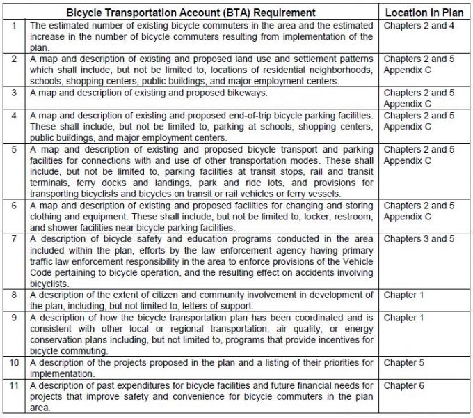
Chapter 1: Introduction
Purpose of Plan
The Mono County Bicycle Transportation Plan is the bicycle transportation plan for the unincorporated area of Mono County. The only incorporated area in Mono County, the Town of Mammoth Lakes, has its own Bicycle Transportation Plan and thus it is not a part of this document. This Plan has been developed in compliance with California Streets and Highways Code Sections 891.2 and 891.4 and in compliance with the requirements for state Bicycle Transportation Account (BTA) funding applications. The Plan further develops the General Bikeway Plan contained in the Mono County Trails Plan (1994) and has been designed to complement similar plans in surrounding counties and communities. The Plan includes the following components:
- Describes existing bicycle facilities and programs in Mono County;
- Analyzes the need for future facilities and programs in the county;
- Designates new routes and prioritizes their development;
- Provides maps for existing and proposed bikeways;
- Establishes policies and standards for the improvement of bicycle facilities and programs; and
- Identifies funding sources and establishes implementation goals for prioritized projects.
Policies in the document recommend that the Mono County Bicycle Transportation Plan should be reviewed and updated every five years, in compliance with state requirements for Bicycle Transportation Account (BTA) funding and to ensure that the plan remains current.
Planning Area
Mono County is a sparsely populated rural county located on the eastern side of the Sierra Nevada mountain range. The State of Nevada forms the county's eastern border. Approximately 94 percent of the county's 3,103 square miles are publicly owned; the area's spectacular scenery of high valleys and rugged mountain ranges has made it a popular recreation destination. The major population center, and the County's only incorporated area, is the Town of Mammoth Lakes. The remainder of residents are scattered in small communities throughout the county.
Communities in the county include Topaz, Coleville and Walker in the Antelope Valley; Bridgeport, the County seat, in the Bridgeport Valley; Mono City and Lee Vining in the Mono Basin; June Lake along the June Lake Loop; Long Valley, McGee Creek, Crowley Lake, Aspen Springs and Sunny Slopes in Long Valley; Swall Meadows and Paradise in the Wheeler Crest area; and Chalfant, Hammil and Benton in the Tri-Valley area.
Mono County is a recreation destination. Throughout the year, there is a significant tourist population in many of the county’s communities and at various recreation destinations such as Mammoth Mountain Ski Area, June Mountain Ski Area, Mono Lake, and Bodie.
Mono County Highways
The state and federal highway system provides the major access to and through Mono County, connecting communities in the county and providing access to and from the county.
- US 395 is the major transportation route in the county. It connects the Eastern Sierra with Southern California and with the Reno/Tahoe region in Northern Nevada. US 395 is also Main Street in Lee Vining, Bridgeport, Walker, Coleville, and Topaz.
- US 6, from the Inyo County line north of Bishop to the Nevada state line, connects the Tri-Valley communities of Benton, Hammil, and Chalfant to Bishop and Inyo County. US 6 is also Main Street in the Tri-Valley communities.
- SR 89 provides access from US 395 to Monitor Pass and is closed in the winter.
- SR 108 provides access from US 395 west to Sonora Pass and is closed in the winter.
- SR 120 provides access from US 395 west to Tioga Pass and east to Benton. The western segment is closed in the winter and the eastern segment may also be closed briefly.
- SR 158, the June Lake Loop, provides access from US 395 to the community of June Lake and is Main Street throughout the June Lake Loop. A portion of SR 158 is closed in the winter.
- SR 167 provides access from US 395 to the Nevada State Line, north of Mono Lake, and access to the community of Mono City.
- SR 168 provides access from US 395 at Big Pine in Inyo County north to Oasis in the southeast corner of Mono County.
- SR 182 provides access from its junction with US 395 in Bridgeport northeast to the Nevada state line and provides the main street access to a portion of the community of Bridgeport.
- SR 203 provides access west from US 395 to Mammoth Lakes.
- SR 266 provides access through Oasis in the southeast corner of the county.
- SR 270 provides access east from US 395 to Bodie State Historic Park and is closed for a portion of the winter.
Mono County Roads
The County currently has 684.15 miles of county maintained roads. Of that maintained mileage, 179.07 miles are paved, 168.47 miles are plowed in the winter, and 197.87 miles traverse National Forest lands. Most of the County roadway system is already established, and the priority is on maintaining the existing circulation system. The need for new facilities are generally addressed in the community policy section (e.g. June Lake) in order to complete the circulation system, alleviate congestion and provide for continued growth. The main access to all communities in the county is state highways, i.e. Highways 395, 158, and 6.
In addition to County roads, there is an extensive network of private and federally controlled roads in the county, many of them unimproved. The federal roads, on lands managed by the Forest Service and Bureau of Land Management, are mostly unmaintained dirt roads that receive limited use from logging trucks, off-highway vehicles (OHVs), mountain bikers. The Forest Service and the BLM have developed management plans for OHV use. The private roads in the county are mostly in community areas and are either substandard roads that do not meet the County Roadway Standards and as a result have not been accepted into the County Roadway Systems, or newer roads established as a part of subdivision development that are maintained by entities such as County Service Areas that are funded by the landowners served.
The transportation systems serving the Bridgeport Indian Colony and the Benton-Paiute Reservation include county roads, tribal roads, and roads managed by the Bureau of Indian Affairs. Transportation needs for each location include road upgrades, ongoing road maintenance, and new road construction to serve existing and proposed development (see Bureau of Indian Affairs, Benton-Paiute Reservation Transportation Plan; Bridgeport Indian Colony Transportation Plan).
Community Participation in Plan Development
Community participation in the development of the Mono County Bicycle Transportation Plan was widespread. Comments received from the following sources have been incorporated into the plan.
Staff made presentations to the following groups to elicit comments on the plan:
- General Public: Staff made presentations at the county’s nine community and Regional Planning Advisory Committees seeking input. These local planning groups work with the county on a variety of planning and development issues. The groups are composed of local residents, along with some local representatives of federal and state agencies.
- Collaborative Planning Team: The Collaborative Planning Team is a multi-agency planning team, consisting of local, state, and federal agencies, which focuses on a variety of planning and resource use issues in the Eastern Sierra. Members include Mono County, the Town of Mammoth Lakes, the Bureau of Land Management, the Lahontan Regional Water Quality Control Board, the California Department of Fish and Game, Caltrans, the Los Angeles Department of Water and Power, the Inyo National Forest, the Humboldt-Toiyabe National Forest, the Benton Paiute Reservation, and the Bridgeport Indian Colony.
Staff contacted the following groups to elicit input on the plan:
- Schools: Eastern Sierra Unified School District and Mammoth Unified School District.
- Bridgeport Indian Colony.
- Benton Paiute Reservation.
- Bodie State Park.
- USFS: Inyo National Forest and Humboldt-Toiyabe National Forest.
- Bureau of Land Management: Bishop Office.
- Bike groups: East Side Velo Club and the Sierra Cycling Foundation.
Consistency with Local Plans
Caltrans
Mono County is located in Caltrans District 9, which operates and maintains all state and federal highways in the county. The district has a bicycle coordinator and a bicycle page on the district website that includes bicycle route maps for the area and route elevation profiles linked to the roadway map (see www.dot.ca.gov/dist9/).
Mono County General Plan
The Bicycle Transportation Plan (BTP) has been developed to be consistent with applicable policies in the Mono County General Plan Circulation Element. The Plan will be attached as an appendix to the Regional Transportation Plan, which is part of the Circulation Element of the General Plan.
Mono County Local Transportation Commission
The BTP has been developed to be consistent with applicable policies in the Mono County Regional Transportation Plan (RTP). The Plan will be attached as an appendix to the RTP.
Bureau of Land Management (BLM)
The BLM actively plans local and regional bikeways on federal lands under its jurisdiction in Mono County. Recreation planners focus primarily on mountain biking and hiking trails for recreational use. Trails and bikeways that could be used as connectors to communities have been incorporated into this plan.
US Forest Service (USFS)
The BTP has been developed to be consistent with applicable policies in the Land and Resource Management Plans for the Inyo National Forest and the Toiyabe-Humboldt National Forest, as well as the management plan for the Mono Basin National Forest Scenic Area.
Inyo County
The BTP has been developed to be consistent with applicable policies and maps in the Inyo County BTP.
Town of Mammoth Lakes
The BTP has been developed to be consistent with applicable policies and maps in the Town of Mammoth Lakes Draft Mobility Element and General Bikeway Plan (2014).
Chapter 2: Needs Assessment
This chapter provides information on existing bicycle facilities in Mono County, including regional and multimodal connections and support facilities and programs. It then identifies Needs and Opportunities for bicycle facilities and programs throughout the county.
Mono County Bikeway Facilities
The unincorporated area of Mono County, outside of the Town of Mammoth Lakes, has few existing bicycle facilities.
Existing Bicycle Routes and Signage
Although cycling is an increasingly popular activity in Mono County, the county lacks facilities specifically for bicyclists. Most cycling occurs on roadways where the shoulder may or may not be wide enough to accommodate bicyclists safely. Mountain bike use occurs throughout the county on dirt roads, which generally are not marked as bike trails. The following are the sections of local roads with markings/signage for bike use:
- Bike Route along Crowley Lake Drive and South Landing Road from Tom’s Place to Crowley Lake
- Bike Route along Pearson Road in Crowley Lake
- North Shore Drive Bike Route in June Lake
- Share the Road signs along Benton Crossing Road
- Share the Road signs along SR 158 in June Lake
- Bicycle/pedestrian bridge over the East Walker River in Bridgeport
- Recently designated bike lane on Main Street (Hwy 395) in Bridgeport
- Eastside Lane Bike Route in the Antelope Valley
Existing Rest Facilities
Rest facilities (e.g. restrooms, drinking water, public phones, and air for tires) and parking facilities (for vehicles and bicycles) are available in most communities at the community center, at private facilities in communities, at schools, at county parks, and at U.S. Forest Service facilities.
Outside of communities, rest facilities and parking facilities are available at U.S. Forest Service facilities (campgrounds and recreational areas), and at private recreational areas (e.g. Twin Lakes, Brown's Campground on Benton Crossing Road, etc.). There are few rest facilities on the many dirt roads in the county used by bicyclists. Most of those roads are on public lands and the applicable land management policy for those areas is generally to keep them as undeveloped recreational areas.
The Eastern Sierra Scenic Byway provides rest facilities along the length of US 395 in Mono County and along SR 120 between Yosemite National Park and US 395.
Existing Parking Facilities
- Bike racks are located at the following locations:
June Lake Library and Community Center
USFS Mono Basin Visitor Center in Lee Vining
Behind Mono Mart in LV for employees
County Annex building in BP
Lee Vining High School
Lee Vining Community Center
Changing Facilities
- No facilities specifically exist for bicycle riders to change clothing (changing facilities) except for restrooms adjacent to the bike racks mentioned above.
Transport Facilities/Public Transit Connections
- All Eastern Sierra Transit buses have bike racks. Shelters have recently been installed at bus stops in communities throughout the county, however, the shelters are not equipped with bike racks.
Bus shelters have been installed in the following locations:
- Crowley Lake Drive, just north of Tom’s Place store
- Community Center in Crowley Lake
- Chalfant at the Community Center
- Lee Vining, in front of the Caltrans Yard and on Hwy 120 at the Mobile Mart (this is a YARTS stop)
- Walker, US 395 southbound near the County Store
- Bridgeport, on Emigrant Street next to the County Park Tennis Courts
Mono County Bicycle Users
The unincorporated area of Mono County, outside of the Town of Mammoth Lakes, has few existing bicycle facilities. With job centers and school locations often outside their community, it is not practical for most people to commute to work on bicycles or for many students to commute to school using bicycles. Both students and workers must often drive many miles to their destination, to a community other than the one in which they reside. However, this gap appears to be closing. The 2009-2013 American Community Survey 5-year Estimate by the U.S. Census Bureau estimates just over a 16 minute mean travel time to work (http://factfinder.census.gov/faces/tableservices/jsf/pages/productview.xhtml?src=bkmk), indicating a more reasonable distance to commute by bicycle. Extreme weather conditions also make it difficult to bicycle year-round; snow and ice in many parts of the county limit winter biking opportunities, while extreme heat and dust storms decrease summer biking opportunities in other areas.
Interest in commuting by bicycle is growing within communities. There is generally limited traffic congestion, and air quality impacts from automobile use are minimal in the county. Bicycling within Mono County communities is a viable opportunity because most Mono County communities are small, with relatively flat topography. Opportunities for recreational bicycling are abundant. Many of the county’s paved roads have little traffic and lead to a variety of scenic recreational destinations.
The County currently has no estimates on the number of existing bicycle commuters in the area, nor the numbers of school children who ride to school. Anecdotal data suggests that numbers for both categories are small. The 2009-2013 American Community Survey 5-year Estimate by the U.S. Census Bureau does not provide a category for bicycle commuters, but does estimate that 13.9% of the population walk to work and 4.5% utilize other transportation means (see http://factfinder.census.gov/faces/tableservices/jsf/pages/productview.xhtml?src=bkmk).
Recreational Use/Bicycling Events
Recreational biking is an increasing tourist attraction in the County, both on county roads and highways and on unpaved roads on public lands. The local cycling community currently produces several large-scale bike event on roads within the County, including the Mammoth Gran Fondo, Everest Challenge, and Pamper Pedal, among others. The Sierra Cycling Foundation has indicated that organizers would like to attract more large scale biking events to the County.
Safety and Education Programs
Several entities within Mono County conduct bicycle safety and educational programs.
- The Mono County Health Department sponsors bicycle safety activities throughout the year in conjunction with other county and town agencies. There are a limited number of bicycle helmets available for children whose families cannot afford to buy one.
- The Town of Mammoth Lakes Police Department continues to have an ongoing program of bicycle safety and education primarily oriented toward elementary school-aged children. The program includes a yearly “Bicycle Rodeo” for all grades, bicycle inspection, bicycle safety handouts, and bicycle registration. The Bicycle Rodeo focuses on riding safety and instruction, helmet use, traffic sign recognition, bicycle lane use, handling cross-walks, hand signals, etc. Bicycles are checked for safety features such as seats, handlebars, brakes, and tires; a special sticker is issued showing inspection. The program is conducted on a yearly basis. Safety handouts are also available for younger children in the first and second grades.
- Sierra Cycling Foundation’s mission is to promote cycling and improve cycling conditions in the Eastern Sierra. SCF advocates bicycle safety and education of cyclists as well as motor vehicle operators. The group strongly supports the “share the road” concept and continually strives to add more miles of “share the road” signs. SCF provides bicycle safety information and suggested routes and rides for cyclists visiting and living in the Eastern Sierra and emphasizes bicycle-safety training for children, mandatory helmet laws, and safer road conditions by working with public works and planning departments in Inyo and Mono counties, the Town of Mammoth Lakes, the city of Bishop and Caltrans, District 9.
- Eastside Velo is a bicycle club registered with the United States Cycling Federation, with about 270 members in 2015. The club organizes rides and events, including the Mammoth Gran Fondo, and is an advocate for road biking in the Eastern Sierra.
Types of Bikeways
The Caltrans Highway Design Manual identifies four types of bicycle facilities:
- Class I Bikeway (Bike path). Separate right-of-way for bicyclists. Generally should serve corridors not served by streets or highways.
- Class II Bikeway (Bike lane). Utilizes the shoulder area of roads. Signing and striping separate areas for bicyclists and motorists.
- Class III Bikeway (Bike route). Similar to a Class II Bikeway, except that the shoulder area is shared with vehicles.
- Shared Roadway (No bikeway designation).
Most of the facilities in the county are Shared Roadways. There is a short Class II Bikeway along Crowley Lake Drive in the vicinity of Aspen Springs and on Bridgeport Main Street. There are also marked mountain bike routes on dirt roads in the western end of Long Valley.
Selection of the appropriate type of bikeway to meet an identified need is dependent on many factors, including safety, demand, and connection to other bike facilities. The Caltrans Highway Design Manual contains criteria to help determine whether designation of a bikeway is appropriate and, if so, which type is most suitable. The relative cost of various types of facilities is also a consideration.
In Mono County, shared roadways (with a 4-foot paved shoulder and 4-inch edge stripe) will continue to be the most feasible type of bikeway in most areas. Relatively low bicycle demand may make it infeasible to designate bikeways; environmental considerations and maintenance costs may make it difficult to develop separate bike paths.
Caltrans’ Requirements to Provide for Bicycle Use
Caltrans is required to provide adequate width for shared use by motorists and bicyclists on new construction and major reconstruction projects. On resurfacing projects, the entire paved shoulder and traveled way must be resurfaced and when adding lanes or turn pockets, a minimum 4-foot shoulder must be provided. These requirements will result (or has resulted) in the development and maintenance of a minimum 4-foot paved roadway shoulder with standard 4-inch striping on many portions of the highway system in Mono County.
Since highways in Mono County receive relatively limited use by bicyclists, it may be inappropriate to designate them as bikeways, particularly since Caltrans' requirements are resulting in adequate on-road facilities. However, special consideration should be given to the placement of rumble strips to better accommodate cyclist needs; the need for regular maintenance of shoulders to ensure safe riding conditions; and pavement surface in rehabilitation projects to ensure conditions suitable for cyclists.
Planning and Design Standards
The Caltrans Highway Design Manual establishes bikeway planning and design in California. Section 1001.2 of the Manual discusses the role of bikeways as “one element of an effort to improve bicycling safety and convenience – either to help accommodate motor vehicle and bicycle traffic on shared roadways, or to complement the road system to meet needs not adequately met by roads.”
Streets and Highway Code Section 890.4 defines a “bikeway” as a facility that is provided primarily for bicycle travel and identifies the three types of bikeways listed above: Class I, II and III bikeways (see Figure 1).
FIGURE 1. Examples of Bikeway Types in Mono County
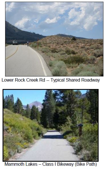
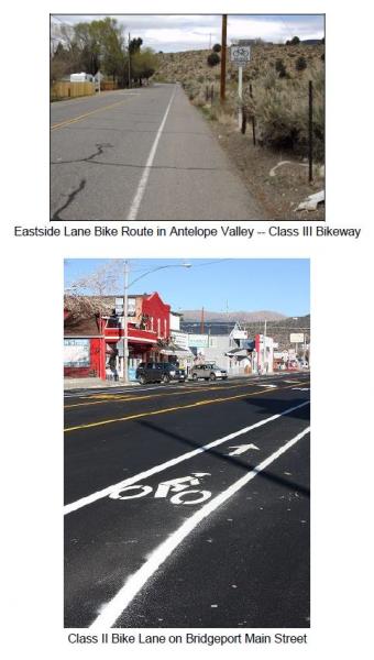
The Design Manual also notes a fourth type of bikeway facility – the Shared Roadway with No Bikeway Designation. Most bicycle travel in the state, and in Mono County, occurs on streets and highways without bikeway designations. The Manual (Section 1002.1) notes that:
Many rural highways are used by touring bicyclists for intercity and recreational travel. It might be inappropriate to designate the highways as bikeways because of the limited use and the lack of continuity with other bike routes. However, the development and maintenance of 4-foot paved roadway shoulders with a standard 4 inch edge line can significantly improve the safety and convenience for bicyclists and motorists along such routes.
Selection of the appropriate type of bikeway to meet an identified need is dependent on many factors, including safety, demand, and connection to other bike facilities. The Caltrans Highway Design Manual contains criteria to help determine whether designation of a bikeway is appropriate and, if so, which type is most suitable. The relative cost of various types of facilities is also a consideration.
Countywide Needs Identified by Local Bicycle Groups
Local bicycling groups, including Eastside Velo and the Sierra Cycling Foundation, have identified several overall needs related to biking in unincorporated Mono County.
- Uphill Bike Lanes
Widening uphill shoulders is the single most important step to achieve consistent auto flow travel, cycle safety and construction economics (build lanes uphill only). Widening uphill sections on the Scenic Loop, Crowley Lake Drive, Benton Crossing Road, lower and upper Rock Creek Road and Highway 120 would be a sensible, economical start.
- Maintenance
Existing roads and shoulders should be maintained. Expansion cracks need to be filled and smoothed with special attention to downhill lanes. Benton Crossing Road and the Scenic Loop are examples of downhill stretches of roads in need of crack filling.
- Cleanliness
Road shoulders should be swept, with uphill sections swept most frequently. Uphill roads with banks and curbs need vacuum-type sweeping rather than pull-broom as the banks trap debris. Major holidays yield more glass and debris.
- Signage
Signs, which indicate cycle traffic, give a heads-up to both cyclists and motorists. "Share the Road" signs on 2-lane roads are an inexpensive yet effective way to create safety for all. "Share the Road" signs would be well suited for the Scenic Loop, Crowley Lake Drive, Twin Lakes Road and Benton Crossing Road. Bike Route signs on SR 203, and on US 395 from Tom's Place to June Lake and eventually to Lee Vining would be ideal.
- Rumble Strips
The size and placement of rumble strips, and resulting safety issues, are a concern. The Sierra Cycling Foundation (SCF) explains that the current placement of rumble strips forces bicyclists onto a dirty shoulder, and advocates for a rumble strip half its current width and placed immediately to the right of the fog line (see http://www.sierracyclingfoundation.org/positions.htm). SCF also advocates for regular maintenance and sweeping of the shoulder.
- Bicycle-friendly Features
In addition to signage, street features should be planned to accommodate bicyclists. For example, the wider plates on cattle guards on Benton Crossing Road enable bicyclists to cross safely (see Figure 2).
FIGURE 2. Example of Bicycle-friendly Cattle Guard on Benton Crossing Road.
Community Needs
Antelope Valley- Antelope Valley has several small communities spread out along the perimeter of the valley. Bicyclists currently use local highways and roadways to move between those communities and through the valley. These roadways are adequate to serve current and future cyclist demand but safety could be improved by widening the shoulders of the roadways and by striping/signage.
- Antelope Valley is separated from the rest of the county by topography. It does not have any nearby recreational destinations popular with cyclists. Opportunities may exist to promote cycling through the Walker Canyon via the Scenic Byway planning effort.
- The Death Ride is held each year that includes a stretch traveling over Monitor Pass to Hwy 395 and back. There may be an opportunity to coordinate efforts with Alpine County to build upon the success of an event that had 3,500 riders in 2012.
- Swauger Creek/Devil's Gate is an isolated residential area where the provision of bikeways has not been an issue.
- Bridgeport needs safe commuter routes for children and others from the Evans Tract and the residential areas on SR 182 to the Main Street area and the school. These could be provided by widening the shoulders and designating a bike route or by designating an alternative route.
- Residents have expressed an interest in developing a bike route between Bridgeport and Twin Lakes, a popular cycling route, either by widening the shoulders on Twin Lakes Road or by creating a separate bike path that parallels Twin Lakes Road. Both alternatives, especially the second, might encounter wetlands which would make development difficult. In addition, a separate bike path would require obtaining easements or rights-of-way, which could be expensive and make the project infeasible.
- Residents are also interested in eventually developing a loop trail connecting the Twin Lakes bike trail to Buckeye Canyon Road and linking that segment to a trail around the reservoir.
- The Bridgeport Main Street planning effort developed and implemented Class II bike lanes through the townsite, establishing an opportunity for additional bicycle connectivity to SR 182 and Twin Lakes Road.
- Mono Basin has a number of dirt roads within the boundaries of the Mono Basin National Forest Scenic Area. Use of those roads is governed by the Comprehensive Management Plan for the Scenic Area, which allows cycling on existing roads.
- US 395 along the west side of Mono Lake does not have adequate shoulders in some areas for safety. Past efforts to expand shoulders were controversial, and the project has since been abandoned by the LTC and Caltrans.
- Major recreational destinations include Mono Lake, the Forest Service Visitor Center, Lundy Canyon, and SR 120/Lee Vining Canyon. Consider connecting these destinations via bike routes.
- Most children at the schools in Lee Vining are bussed to school or walk. Commuting routes for school children are limited.
- Policies in the June Lake Area Plan focus on creating a more inviting and walkable community, and providing alternatives to automobile use. The June Lake Multimodal Plan addressed these concerns, and has since been incorporated directly into the Regional Transportation Plan.
- The main bike route to and through June Lake is SR 158, a narrow, winding route without sufficient shoulders. This is an extremely popular touring route. Safety on this route is a high concern, particularly for cyclists between June Lake Village and the Down Canyon area.
- Public lands surrounding the June Lake Junction, and between June Lake and Mammoth Lakes, contain an extensive system of roads used by mountain bicyclists and off-highway vehicles. There are opportunities to link community bikeways to those roads. In addition, an alternative route parallel to US 395 could be investigated between June Lake and Lee Vining. The USFS continues their effort to highlight routes and eliminate duplicative paths of disturbance.
- Parking facilities for bicycles are limited in June Lake. Additional facilities could be provided in the Village and at the lakes.
- Share-the-road signs along North Shore Drive have been placed to enhance bicycle safety and use, and there is an opportunity to integrate cycling amenities at the Rodeo Grounds/West Village and plan bike paths to access the June Lake Ballfield, parks, and the lakes.
- The western portion of Long Valley is primarily a recreational area. There is no year-round residential development in the area. The area contains an extensive dirt road system, which is mapped in the Interagency OHV Maps. The Inyo National Forest has signed a few roads north of Casa Diablo and north of Mammoth Lakes as bike trails. Maps of those trails are available from the Forest. This is a very popular area with cyclists; additional trail markings may be appropriate.
- There is a potential to connect trails in Mammoth Lakes with trails to the surrounding area by signing existing roads as bike trails.
- The Long Valley area includes the communities of Sunny Slopes/Tom's Place, Aspen Springs, Crowley Lake/Hilton Creek, McGee Creek, and Long Valley. These residential communities have limited commercial activities. Many of the residents work in Mammoth; most of the children go to school in Mammoth.
- Crowley Lake Drive, from Tom's Place to Long Valley, is used for biking by both residents and visitors. The County constructed a bike path along Crowley Lake Drive, from South Landing Road to the Community Library and Park.
- There are a number of recreational areas popular with bicyclists in and adjacent to Long Valley, i.e. Rock Creek Canyon, Owens Gorge Road, Convict Lake Road, and Benton Crossing Road. Rock Creek Canyon and Owens Gorge Road are accessible from the community areas along Crowley Lake Drive. Convict Lake Road and Benton Crossing Road are not accessible except by riding on US 395. Residents are interested in providing alternative routes to US 395. The Interagency OHV Maps show that an alternative route from Crowley Lake to the Convict Lake Road would be possible. An alternative route to Benton Crossing Road would not be possible. Improvements to Rock Creek Road are being completed in 2015, including new pavement surface, bridge rehabilitations, and the addition of a bicycle climbing lane.
- Benton Crossing Road is extremely popular with residents and visitors for cycling. The Circulation Element/RTP contains a policy to designate a bike trail around Crowley Lake on Benton Crossing Road.
- The Circulation Element/RTP also contains a policy to designate a bike trail from Long Valley to Mammoth Lakes. Currently riders must use US 395. A loop from Mammoth Lakes to the Crowley area is another extremely popular cycling route.
- Wheeler Crest and Paradise are somewhat isolated residential areas. The only access road through the area, Lower Rock Creek Road, provides an alternative route to travel on US 395 between Long Valley and Bishop, as well as access to recreational areas along Lower Rock Creek. Lower Rock Creek Road is a narrow, 2-lane road. Residents are interested in providing a bikeway along Lower Rock Creek Road from the Inyo County line to Tom’s Place / Crowley Lake Drive.
- There are limited rest facilities along Lower Rock Creek Road.
- Lower Rock Creek Road is a significant attraction for road bicyclists, and for mountain bikers who utilize the biking/hiking trail adjacent to the road. A staging area is located at the southern end of the trail along the road near the Inyo County line.
Tri-Valley
- Bicyclists utilize SR 120 and SR 6 in the Tri-Valley area (Benton, Hammil, and Chalfant) for touring or long day trips. Increased safety on those roads is a concern.
- Limited rest facilities (restrooms, water) are located at the community parks in Benton and Chalfant. There are no official turnouts along SR 120 and SR 6.
- Chalfant has become a bedroom community for the City of Bishop, approximately 12 miles south in Inyo County. Residents have expressed an interest in developing a bike route between Chalfant and Bishop, either by widening the shoulder of SR 6 or by developing an alternative route. Although many residents of Chalfant commute to Bishop to work, the potential for commuter bicycle use is not high. The distance involved, extreme hot and cold weather conditions throughout the year, and heavy winds do not make commuting by bicycle particularly attractive.
- There is a need for safe bike routes. These could be provided by widening the shoulders and designating a bike route or by designating an alternative route, particularly on Chalfant Road and Valley Road.
- Recreational bicycle use of the Tri-Valley area is limited. There is some interest in developing a bike route to Fish Slough. Another potential bike route is Chalfant Loop Road, connecting Chalfant with White Mountain Estates.
- Oasis is an isolated agricultural area where the provision of bikeways has not been an issue.
Chapter 3: Policies
The following goals, policies and programs provide specific direction for the planning and implementation of bicycle facilities in Mono County. The policies have been developed to be consistent with, and complementary to, policies in the Mono County Circulation Element, the Mono County Regional Transportation Plan, the Inyo County Collaborative Bikeways Plan, and the Town of Mammoth Lakes Mobility Plan.
Countywide System
Goal 1. Develop a cohesive regional and community bikeway system that provides safe and convenient access to all communities and recreational opportunities in Mono County.
Policy 1.A. Maintain a Bikeway Master Plan that identifies existing and future needs, and provides specific recommendations for facilities and programs including adequate provisions for bicycle use to, within, and from Mono County.
Action 1.A.1. Review the Mono County Bicycle Transportation Plan biannually and revise as necessary.
Policy 1.B. Develop a system of community bikeways that connect commercial, recreational and residential areas in communities and that link communities to regional bike routes.
Policy 1.C. Designate regional bike routes that connect communities and that allow for regional travel to, within, and from Mono County.
Policy 1.D. Require all bikeways to conform to design standards contained in the latest version, of the Highway Design Manual, Chapter 1000: Bikeway Planning and Design Caltrans, unless otherwise established by the County.
Policy 1.E. Consider a proposed route's importance in providing access and connectivity to adjacent bikeway facilities and destinations when recommending bike routes for implementation.
Action 1.E.1. Coordinate with the Town of Mammoth Lakes, Inyo County and other governmental entities to ensure consistency with existing and planned bikeway systems.
Policy 1.F. Integrate bicycle planning with other county and community planning, including land use and transportation planning.
Action 1.F.1. Seek opportunities for Federal, State, County and Town joint participation, when appropriate, in the construction and maintenance of bikeways and associated facilities.
Action 1.F.2. Work with community groups and local cycling groups on the development and maintenance of bikeways and associated facilities.
Action 1.F.3. Work with appropriate agencies and organizations to obtain funding for bikeways development.
Commuting
Goal 2. Develop and implement a bikeway system that facilitates commuting to work, businesses, and schools.
Policy 2.A. Develop safe and convenient bikeway routes and facilities for all schools in the county.
Action 2.A.1. Implement the school bicycle routes contained in this plan.
Action 2.A.2. Ensure that funding remains available to maintain bicycle routes on an ongoing basis.
Action 2.A.3. Work with school districts, Caltrans, and the County to develop safe crossings, in order to minimize conflicts between bicyclists and vehicles near school.
Action 2.A.4. Work with school districts to obtain and install safe and convenient bicycle parking facilities at schools.
Action 2.A.5. Continue to implement ongoing safety programs that educate school children in safe bicycle riding.
Action 2.A.6. Pursue Safe Route to School funding for appropriate projects.
Action 2.A.7. Ensure that developers of large-scale projects within commuting distance of a school provide bikeways within the development.
Policy 2.B. Develop safe and convenient bikeway routes and facilities to employment centers throughout the county.
Action 2.B.1. Implement the commuting bicycle routes contained in this plan.
Action 2.B.2. Ensure that funding remains available to maintain bicycle routes on an ongoing basis.
Action 2.B.3. Work with Caltrans and the County to develop safe crossings, in order to minimize conflicts between bicyclists and vehicles in community areas.
Action 2.B.4. Work with local agencies, businesses and community groups to provide additional bicycle parking facilities in community areas.
Action 2.B.5. Work with the County to install safe and convenient bicycle parking facilities at County facilities.
Action 2.B.6. Encourage employers to provide bicycle commuter amenities (secure bicycle storage, changing facilities).
Action 2.B.7. Ensure that developers of large-scale projects provide bikeways connecting to existing local bikeways and/or access to community facilities and services (e.g. employment, shopping and services, recreational areas).
Policy 2.C. Where possible, develop commuting routes as part of multimodal facilities.
Action 2.C.1. Where applicable, develop multi-use routes that serve the needs of multiple users.
Action 2.C.2. Work with the County and local transit providers to install bicycle parking facilities at all bus stops.
Action 2.C.3. Work with local transit providers to ensure that all local and regional busses have bicycle racks.
Action 2.C.4. Consider installing bicycle parking at all airports in the County.
Policy 2.D. Identify community bike routes and commuting routes in order to increase usage and safety.
Action 2.D.1. Work with local agencies, businesses and community groups to develop and distribute maps depicting community bikeways.
Action 2.D.2. Develop and implement a uniform signage program to identify community bikeways and to direct bicyclists to public rest and parking facilities (at community centers, county parks, etc.).
Recreational Use
Goal 3. Develop and implement a bikeway system that supports bicycle-oriented recreation.
Policy 3.A. Support mountain biking opportunities within the Eastern Sierra.
Action 3.A.1. Work with land management agencies to identify mountain biking opportunities on existing roads on public lands.
Action 3.A.2. Develop and implement a uniform signage program to identify mountain biking routes and to direct bicyclists to biking facilities (parking, restrooms, etc.).
Action 3.A.3. Work with Caltrans, the Town of Mammoth Lakes, Inyo County, the Collaborative Planning Team, land management agencies, local biking groups, and other interested entities to develop promotional materials (printed, video, online) that highlight biking opportunities in the Eastern Sierra.
Action 3.A.4. Work with local agencies, businesses and community groups to develop and distribute maps depicting mountain biking routes.
Policy 3.B. Support on-road bicycle touring opportunities within the Eastern Sierra.
Action 3.B.1. Work with local biking groups to identify bicycle touring opportunities within the Eastern Sierra.
Action 3.B.2. Develop and implement a uniform signage program to identify bicycle touring routes and to direct bicyclists to biking facilities (parking, restrooms, etc.).
Action 3.B.3. Work with Caltrans, the Town of Mammoth Lakes, Inyo County, the Collaborative Planning Team, land management agencies, local biking groups, and other interested entities to develop promotional materials (printed, video, online) that highlight biking opportunities in the Eastern Sierra.
Action 3.B.4. Work with local agencies, businesses and community groups to develop and distribute maps depicting touring routes.
Policy 3.C. Support bicycling events in the Eastern Sierra, including organized tours, races, century rides, and similar events.
Action 3.C.1. Work with local biking groups to identify and support organized bike events.
Action 3.C.2. Plan and implement County and Caltrans road maintenance activities in order to provide the best possible experience for on-road events.
Policy 3.D. Provide additional facilities to encourage and promote recreational bicycle use within the Eastern Sierra.
Action 3.D.1. Work with appropriate entities to ensure that the County’s recreational destinations provide facilities for bicyclists, including parking.
Action 3.D.2. Work with land management agencies and the County to develop facilities that provide for touring bicyclists (e.g. campsites with bicycle parking facilities) at existing campgrounds.
Action 3.D.3. Ensure that informational kiosks along highways provide information on bicycle routes in the Eastern Sierra.
System Planning, Design, and Implementation
Goal 4. Implement land use and transportation planning, funding, and design practices that support bicycling.
Policy 4.A. Planning for all types of bicycling shall be a high priority in the existing land use and transportation planning process.
Action 4.A.1. The County’s CIP shall include bicycling improvement projects.
Action 4.A.2. Consider amending the County’s Land Development Regulations to include requirements for the provision of bicycling facilities in new development and redevelopment.
Action 4.A.3. Consider amending the County’s Road Standards to clarify requirements for the provision of bicycling facilities on county roads.
Action 4.A.4. Development or improvement to bikeways, in many cases, will be dependent on roadway improvements. Consult with Caltrans, the Mono County Department of Public Works, and the Forest Service concerning schedules for roadway improvements. Ensure that bikeway needs are considered/included during planning of roadway improvements (rehabilitation, maintenance, widening).
Action 4.A.5. Include bikeway facilities in appropriate local, state, and federal agency development projects.
Action 4.A.6. Development of bikeways on county roads should be consistent with goals and policies for bikeways development and recreational use on adjacent public lands.
Action 4.A.7. Provide input to Federal and State agencies on the development of bike routes on public lands.
Policy 4.B. Design bikeways to provide a safe, efficient, multimodal, well-connected system.
Action 4.B.1. Work with appropriate agencies to develop bikeways and associated facilities that connect to existing trail systems.
Action 4.B.2. When possible, plan and develop bikeways as multi-use year-round facilities.
Action 4.B.3. Where possible, develop bike routes to allow for future connections to an expanded transit system.
Action 4.B.4. Provide developed bikeways and facilities on the most heavily used routes in the County. Maintain the semi-primitive recreational experience in other areas.
Action 4.B.5. Ensure that new and existing bikeways conform to the latest design standards.
Maintenance
Goal 5. Maintain bikeways to provide safe riding conditions.
Policy 5.A. Maintain all bikeways (both on roads and separated bikeways) regularly to provide a safe riding surface.
Action 5.A.1. Sweep roadways as frequently as feasible to keep bicycle travel areas free of debris, including during winter months, as necessary.
Action 5.A.2. Encourage Caltrans to budget for highway maintenance and the maintenance of bicycle facilities, to the highest degree possible.
Action 5.A.3. Ensure that accident debris is removed from the entire roadway, including bicycle lanes, as soon as feasible.
Action 5.A.4. Correct safety concerns on area roadways, such as hazardous rumble strips and inadequate shoulders, through ongoing road maintenance and rehabilitation programs, when feasible.
Action 5.A.5. Maintain bike lane striping and pavement markings, to ensure continued legibility.
Safety Education
Goal 6. Create a safe environment for all bicycle users.
Policy 6.A. Educate bicyclists on how to ride safely.
Action 6.A.1. Work with school districts and the County Office of Education to ensure that all schools provide bicycle safety programs.
Action 6.A.2. Work with local cycling groups to provide safety programs for adults.
Action 6.A.3. Work with local cycling groups to provide safety information for visitors to the area.
Action 6.A.4. Pursue funding opportunities for bicycle safety programs.
Policy 6.B. Educate motorists about sharing the road with bicyclists.
Action 6.B.1. Provide additional share the road signs throughout the County.
Action 6.B.2. Include information about bicycle safety at all informational kiosks along highways.
Policy 6.C. Coordinate bicycle safety efforts among affected local agencies/entities.
Action 6.C.1. Encourage Caltrans District 9 to expand its bicycle webpage and to provide safety information on that webpage, as well as a means of reporting safety and maintenance issues on highways.
Action 6.C.2. Work with Caltrans, the Town of Mammoth Lakes, Inyo County, the Collaborative Planning Team, land management agencies, local biking groups, and other interested entities to develop safety materials (printed, video, online) that specifically address biking opportunities in the Eastern Sierra.
Funding
Goal 7. Ensure that funding is available to develop bikeways and facilities in Mono County.
Policy 7.A. Fiscal analyses for proposed bikeways development projects should consider both construction and maintenance costs.
Policy 7.B. Funding efforts should focus on developing community bikeways and associated facilities. Within communities, focus funding efforts on proposed bikeways where bicyclist demand is highest, safety concerns are greatest, and where roadway improvements will not necessarily improve biking conditions.
Policy 7.C. Countywide funding priorities for bikeways development should be established in the Capital Improvement Program (CIP) for Mono County.
Action 7.C.1. The County shall include applicable bikeways development projects identified in this Plan in its Capital Improvement Program (CIP).
Policy 7.D. Pursue all funding options for bicycle facility construction and maintenance.
Action 7.D.1. Utilize the CIP to identify proposed projects for applicable bicycle funding sources, such as the California Bicycle Transportation Account (BTA).
Action 7.D.2. Pursue funding from the BTA and Safe Schools Program to complete identified priority projects.
Action 7.D.3. Include proposed bikeways in roadway improvement projects whenever possible.
Action 7.D.4. Use existing funding as matching funds for state and federal funding.
Policy 7.E. Develop a strategic plan in consultation with Federal, State, and local agencies for coordinating and applying for bikeways funding.
Action 7.E.1. Prepare joint applications for bikeways projects, whenever possible.
Policy 7.F. Revise funding priorities annually, to reflect changes in funding availability and local and regional needs.
Action 7.F.1. Update funding information annually, including available programs for bikeway facilities, specific funding requirements, and deadlines.
Community Policies
Community Policies for Bikeways Development
Community policies were not developed for areas with little or no bicycle use and no identified issues (i.e. Swauger Creek/Devil's Gate and Oasis), or for areas with primarily regional routes (Mammoth Vicinity/Upper Owens, Wheeler Crest/Paradise).
Goal 8. Support bicycling safety, connectivity and facilities based on the needs in individual communities.
Antelope ValleyPolicy 8.A. Develop a loop bikeway route in the Antelope Valley by widening the shoulders on designated portions of US 395, Topaz Lane, Cunningham Lane, Larson Lane, and Eastside Lane.
Policy 8.B. Develop one or more informational kiosks along the loop route that discuss the Valley's history and natural setting.
Bridgeport ValleyPolicy 8.C. Develop a bikeway along SR 182 from the reservoir to town and along US 395 from the Evans Tract to town.
Policy 8.D. Develop a bike route from Bridgeport to Twin Lakes by widening the shoulder along Twin Lakes Road.
Policy 8.E. Provide interpretive signing in the Bridgeport Valley that discusses the Valley's ranching history, natural setting, and how to avoid potential user conflicts and resource damage.
Policy 8.F. Work with the Forest Service to develop a signed bike route along Timber Harvest Road and Reservoir Road.
Policy 8.G. Provide additional signage in Bridgeport directing cyclists to rest facilities at the park.
Policy 8.H. Provide increased recreation opportunities for mountain biking enthusiasts.
Policy 8.I. For trails connecting residential and recreational areas, consider multi-use trails capable of accommodating many modes of transportation.
Mono BasinPolicy 8.J. Work with Caltrans to develop a safe bike route on US 395 along the west side of Mono Lake from Lee Vining to the County park.
Policy 8.K. Work with appropriate agencies to develop a bike trail from Lee Vining to the campgrounds in Lee Vining Canyon, utilizing existing roads where possible.
Policy 8.L. Continue community conversations to consider a bike trail connecting Mono City to Lundy Canyon which, in concert with Policies 8.J. and 8.K., connect Lundy Canyon to the County park, Mono City, Lee Vining, and Lee Vining Canyon.
Policy 8.M. Work with community groups and businesses to provide additional bike racks in Lee Vining.
Policy 8.N. Provide signage in Lee Vining to direct cyclists to rest facilities at the park.
June Lake LoopPolicy 8.O. Develop bike routes in June Lake in conformance with the June Lake policies in the Regional Transportation Plan.
Policy 8.P. Link the bike routes in June Lake to popular recreational areas surrounding the June Lake Loop.
Policy 8.Q. Work with community groups and businesses to provide additional bike racks in the June Lake Village, at the marinas, and at the parks.
Long Valley
Policy 8.R. Provide community bike paths in Crowley Lake as follows:
- Widen shoulders along Crowley Lake Drive from Tom's Place to Long Valley, to provide for bicycle safety (tie to resurfacing of Crowley Lake Drive);
(Note: Sections of this route should be prioritized)
- Widen shoulders along South Landing Road, from Crowley Lake Drive to Crowley Lake, to provide for bicycle safety (this requires acquiring the right-of-way from Lakeview Subdivision north);
Policy 8.S. Work with Caltrans and the Forest Service to develop and implement standardized signing for bike routes on Sherwin Creek Road, Owens Gorge Road, and Substation Road.
Policy 8.T. Work with community groups and businesses to provide bike racks at appropriate places in Crowley Lake.
Wheeler Crest/ParadisePolicy 8.U. Provide a bikeway along Lower Rock Creek Road (e.g. bicycle climbing lane from the Inyo County line to Tom’s Place/Crowley Lake Drive)
Policy 8.V. Work with community members prior to the development of new trail planning efforts.
Policy 8.W. Work with the community, user groups and the BLM to maintain and improve Lower Rock Creek Trail (e.g. volunteer work days, wayfinding, etiquette and/or additional user facilities).
Tri-ValleyPolicy 8.X. Work with the Forest Service to develop a bike route to Fish Slough and to provide interpretive signing at Fish Slough.
Policy 8.Y. Improve signage directing cyclists to rest facilities at parks in Benton and Chalfant.
Chapter 4: Demand for Bicycle Facilities
Current and future demand for bicycle facilities in Mono County is difficult to measure or project since the County has no data on bicycle trips other than the extremely limited data from the 2000 Census. The 2010 Census does not provide any information on estimated number of bicycle trips in Mono County. The following sections analyze existing and future bicycle demand in relationship to the County’s overall goal of developing a cohesive regional and community bikeway system for Mono County.
Land Use Patterns
A general pattern of development recurs throughout the County. Development is concentrated in small communities located along US 395 or SR 6 (with the exception of Wheeler Crest and Paradise); recreational uses are dispersed throughout the county. Most of the limited amount of private land in the county is located in community areas. Public lands (94 percent of the land in the county) generally remain as open space and are used for a variety of recreational uses, including biking.
Most of the development in the county is low density; the most intense development occurs in the Town of Mammoth Lakes. Communities generally have a small commercial area surrounded by low-density residential development. Some communities (June Lake, Lee Vining, Bridgeport, Crowley Lake) have limited numbers of multiple family housing units mixed in with their commercial uses.
The Town of Mammoth Lakes is the major activity center in the county. Most of the services available in the county are provided there, along with the majority of shopping opportunities. Limited services, including schools, are available in some communities in the unincorporated area, primarily in Bridgeport where government offices are located. Several recreational destinations, such as Mono Lake and Bodie State Historic Park, have visitor centers and a definite center of activity. Many of the county’s other recreational destinations are dispersed with no defined activity center.
Bicycle Demand
Demand for bicycle facilities in Mono County falls into four categories:
- Bicycle routes for residents and visitors for alternate transportation and commuting between camping areas, day use areas, commercial areas, and businesses and employment.
- Bicycle routes for residents and visitors to Mono County for recreational use, sightseeing, and exercise.
- Safe bicycle routes in each community for children commuting to and from school and other activities.
- Safe bicycle routes for long distance riders on state and local highways and roadways.
There is currently limited demand by residents for commuting routes; this is unlikely to change. Land use patterns in the County have created a situation where it is not practical for most people to commute to work on bicycles or for many students to commute to school using bicycles. Both students and workers must often drive many miles to their destination, to a community other than the one in which they reside. Extreme weather conditions also make it difficult to bicycle year-round; snow and ice in many parts of the county eliminate winter biking opportunities, while extreme heat and dust storms decrease summer biking opportunities in other areas. Depending on the destination, safety considerations may eliminate the possibility of biking within communities. Many access routes in communities are either along highways or cross highways, often without adequate shoulders.
Increasing safety within communities and between communities and providing connections between Mammoth Lakes and surrounding communities would increase bicycling opportunities and demand.
Recreational use continues to increase. There is a need for a variety of recreational biking opportunities, ranging from short paved paths appropriate for family biking experiences, to long distance touring routes, and off-road experiences. When designating bike routes, it is important to remember that recreational users are looking for that variety.
Population Projections
Mono County’s population in 2007 was estimated to be 14,625 persons; 8,275 persons (60 percent) in Mammoth Lakes and 6,250 persons (40 percent) in the unincorporated portion of the county (see Table 1). The percentage of the overall population that lives in Mammoth Lakes has increased slightly since 2000.
TABLE 2. Mono County Population Estimates, 2015
Table 2 shows population projections for the county for the next 25 years. It includes the percent of the population over the age of 15 as an indicator of the number of people who may be commuting and the percent of the population aged 15-69 as an indicator of the number of people most likely to be commuting. Over the next 25 years, the percentage of the population older than 15 is expected to remain stable at 84 percent while the percentage of the population aged 15-69 is expected to decrease slightly as the population ages.
TABLE 3. Mono County Population Projections, 2020-2040
Table 3 shows population projections by community areas through the year 2040. The community projections are based on the following assumptions: that the unincorporated area will continue to house approximately 43 percent of the total countywide population and that the population distribution in the unincorporated community areas will remain similar to the population distribution in 2010. The last assumption may not hold true. Antelope Valley is experiencing increasing development pressures from the Gardnerville/Carson City area; Chalfant is experiencing a similar pressure for expansion from the Bishop area; and Benton, Chalfant, and the Long Valley communities are experiencing continuing pressure from residents who work in Mammoth. As housing prices continue to rise in Mammoth Lakes, other areas of the county may experience increasing development pressure.
It is important to note that the population projections shown in Table 3 are for permanent year-round residents. Mono County, and particularly community areas such as Mammoth Lakes and June Lake, experiences much higher peak populations during periods of heavy recreational use, a factor that has a direct impact on the transportation system. Projected peak populations are utilized to determine transportation/travel demand in Mammoth Lakes and June Lake.
TABLE 4. Mono County Community Population Projections, 2010-2040
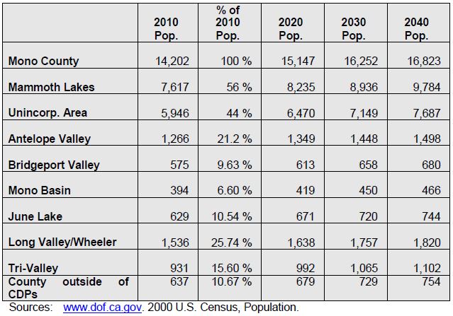
Land Use Forecasts
Development in Mono County communities is primarily residential with limited small-scale commercial uses serving local and tourist/recreational needs. Limited small-scale light industrial uses, such as heavy equipment storage and road yards, also occur in some county communities. Most communities also have public facilities such as schools, libraries, community centers, parks and ballfields, and government offices (in Bridgeport). This development pattern is not anticipated to change, due to the small scale of communities in Mono County, the limited private land base for expansion, and the lack of employment opportunities in most communities.
The Land Use Element of the County's General Plan contains policies that focus future growth in and adjacent to existing communities. Substantial additional development outside of existing communities is limited by environmental constraints, the lack of large parcels of privately owned land, and the cost of providing infrastructure and services in isolated areas. Land use policies for community areas in the county (developed by the county’s citizens regional planning advisory committees) focus on sustaining the livability and economic vitality of community areas. The General Plan anticipates that growth in the unincorporated area will occur primarily in the Antelope Valley, Bridgeport Valley, June Lake, Wheeler Crest/Paradise, the Tri-Valley, and Long Valley.
Employment
Mono County's economy is dominated by services, retail trade and government. Industry projections from the California Employment Development Department for the Eastern Sierra Region estimate that job growth in the area between 2004 and 2014 will be strongest in Leisure and Hospitality Services, Government, Retail Trade, and Trade, Transportation and Utilities. Major job centers are located in Mammoth Lakes (services, retail trade, government), June Lake (seasonal services and retail trade) and Bridgeport (government). Despite the availability of Commercial (C) and Mixed Use (MU) zoning throughout communities in the unincorporated area, it is unlikely that sufficient jobs will develop to eliminate the need for workers to commute to jobs outside their communities.
Employment trends for the unincorporated area vary from the County as a whole, with higher percentages in agriculture, construction and mining (particularly mining), manufacturing, transportation and public utilities, and services, and lower percentages in wholesale trade, retail trade, finance, insurance, real estate, and government.
Employment data for September, 2009, from the Employment Development Department show the following current employment by industry (not seasonally adjusted):
Total Wage and Salary 6,280
Leisure and Hospitality 2,870
Government 1,650
Trade, Transportation and Utilities 600
Retail Trade 490
Goods Producing 390
Financial Activities 260
Professional and Business Services 240
Transportation, Warehousing and Utilities 100
Educational and Health Services 40
Manufacturing 40
Farm 20
Wholesale Trade 10
The following list of major employers in Mono County was developed using the 2009 America's Labor Market Information System Employer Database (California Employment Development Department, www.labormarketinfo.edd.ca.gov). Many of these employers are located in Mammoth Lakes, a significant commute from many areas of the County.
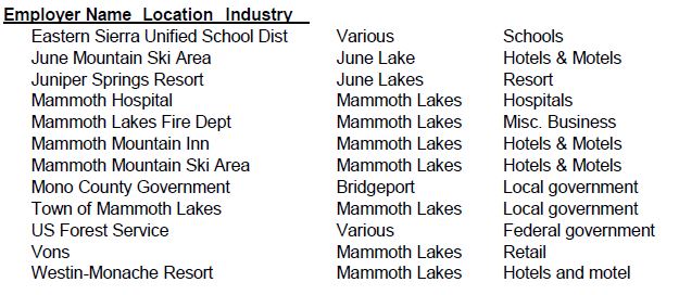
Place of Work
The 2009-2013 American Community Survey 5-year Estimate[1] indicated 99% of workers 16 years and older residing in unincorporated Mono County worked within the state and 91% worked within Mono County. These numbers indicate a significant increase in the jobs/housing balance over 2000, when only 75% worked in the state and county (US Census 2000, Summary File 3, Tables P 31 and P32). The mean travel time to work also decreased from less than 30 minutes in 2000 to just over 16 minutes in the 2009-2013 estimate. The primary means of transportation to work was a car, truck or van (67%). Of these, 54% were single-occupancy vehicles and 13% were carpools with two or more persons. Walking accounted for 14% of commuters, followed by public transportation (5%), bicycling (2.5%), and taxicab/motorcycle/other (2%). Workers from home constituted 10%.
The most recent data on travel times from communities to work locations is from the 2000 Census. The 2010 Census does not appear to provide this information. In 2000, travel times to work were highest in Antelope Valley and Tri-Valley, reflecting the fact that many residents of those areas work outside the community. A large number of Long Valley/Wheeler Crest workers commuted between 30 and 44 minutes, probably to Bishop or other points in Inyo County (see Table 4).
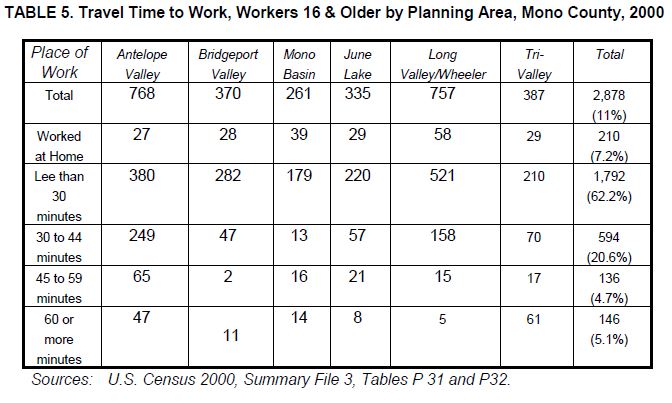
Future Demand
Future demand for bicycle facilities in Mono County is difficult to project since the County has no data on bicycle trips other than the extremely limited data from the 2000 Census. Data from the 2000 US Census show that only 3 out of 2,878 daily trips in the unincorporated area were made via bicycle (2000 US Census, SF3, P30), less than one percent of the total. In 2000, 298 daily trips to work were made by walking, approximately 10 percent of the total trips. The 2010 Census does not provide estimates on bicycle trips.
Many Mono County communities are small enough to allow commuting by bicycle. However, as discussed previously, many County residents do not work in the community in which they live. This is unlikely to change, since most communities are primarily residential with limited employment opportunities. Commuting between communities is difficult due to the distances involved, the terrain, and unfavorable weather conditions much of the year.
Enhancements to bicycle facilities within communities could increase the use of bicycles for commuting and trips to school. The development of additional bicycle facilities between community areas could increase commuting between certain communities when the weather is favorable.
Future demand for recreational bicycle use throughout the County is expected to continue. The development of additional bicycle facilities intended for recreational users and the continued enhancement of County roads and highways to provide an optimum experience for recreational users is expected to increase recreational cycling.
Chapter 5: Proposed Bikeway System
This chapter contains descriptions and maps of existing and proposed bicycle facilities and programs in Mono County. The criteria utilized to develop and prioritize the projects for the bicycle system are based on the information in prior chapters in this plan, i.e. Chapter 2: Needs Assessment, Chapter 3: Policies, and Chapter 4: Demand for Bicycle Facilities. As projects are more fully scoped and developed, adequate environmental documentation will also be developed to meet California Environmental Quality Act requirements.
Bicycle System Selection Criteria
The overall goal of this Plan is to “develop a cohesive regional and community bikeway system that provides safe and convenient access to all communities and recreational opportunities in Mono County.” In order to achieve this goal, the following criteria were utilized to develop the proposed bikeway system for the unincorporated areas of Mono County:
- The routes use existing roads and facilities where possible in order to provide the most cost effective bicycle system. New routes/facilities are considered when safety and convenience would be maximized by developing such routes and when the development of such routes would increase bicycle use.
- Proposed routes connect residential areas, schools, commercial areas, and local parks in order to develop community bicycle routes.
- The routes provide continuity with bicycle routes and trails in surrounding communities and counties, providing access to recreational destinations, in order to develop regional bicycle routes.
- The routes maximize multimodal connections within the County and to and from the County.
- Proposed bicycle routes and facilities maximize safety.
- Support facilities are included in the development of the system in order to maximize safety and convenience and to encourage additional use of the system.
- Educational/promotional programs are included in the development of the system in order to maximize safety and to encourage additional use of the system.
Proposed Bicycle Routes
Bike routes identified in this plan provide for:
- The commuting needs of employees, businesspersons, shoppers and students;
- Connection of community areas to local and regional recreational areas and existing trail systems;
- The needs of recreational bicyclists;
- Parking and rest facilities; and
- Multiple use of facilities where possible.
Popular touring routes traversing the entire county are included along with local routes focused in communities. Maps identifying both the regional routes and the community routes are shown on the following pages.
Proposed Support Facilities
- Parking. Secure, convenient bike parking is a key component of a bicycle system and a cost effective way to encourage additional use of the system. The County currently has very few bike racks. Policies in this plan require the County to work with applicable agencies to get bike racks installed at schools, within communities, and at recreational destinations.
- Storage and Changing Facilities. Due to the relatively low volumes of commuters in the County, facilities for storing clothing and equipment and for changing are not a priority. This need will continue to be met by employers in the near future.
- Multimodal Facilities. Multimodal facilities may include bike racks at bus stops and trailheads, bike racks on buses, and bike racks at airports. Due to the distances between communities in the County, use of several forms of transportation may prove more feasible than biking alone. The availability of safe, convenient bike racks could encourage additional use of other forms of transportation.
- Signage. Since many of the bicycle routes within the County are on county roads or state highways, clear signage is critical. Policies in this plan require the development and implementation of a uniform sign program throughout the County, and the installation of additional share the road signs.
- Lighting. Lighting, particularly adjacent to bicycle parking facilities, may enhance the safety of the system. Lighting in Mono County communities should minimize glare on adjacent properties. Streetlights in Mono County communities are generally sufficient for on-street bike routes.
Education and Safety Programs
- Safety Education Programs. Limited bicycle safety programs are available in the County; those programs focus on school children. Since many of the bike routes within the County are on-street routes and many are located along rural highways with unique safety issues, additional safety programs geared towards visitors and touring cyclists would increase safety.
- Signage. As discussed above, additional signage, particularly in areas where bicyclists must share the road with motorists, will increase safety for all.
- Maps. Maps, videos, and websites with information on local and regional bike routes could increase bicycle use by showing riders potential routes and connections to services and facilities. Limited maps are currently available on various websites, including Caltrans District 9’s bike page. A comprehensive, regional map showing both on- and off-street routes, connections to communities and recreational destinations, and facilities would highlight the importance of bicycling in the Eastern Sierra.
Potential Projects
The following potential projects are based on the needs identified by local cycling groups and on recommended projects developed by community members in consultation with staff. Some of these projects are included in the County’s existing General Bikeway Plan, others are newly developed.
TABLE 6. Potential Projects
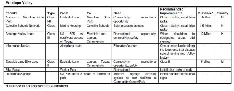
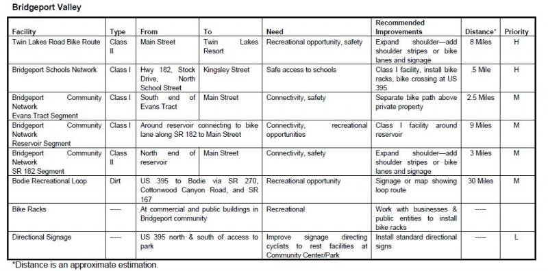
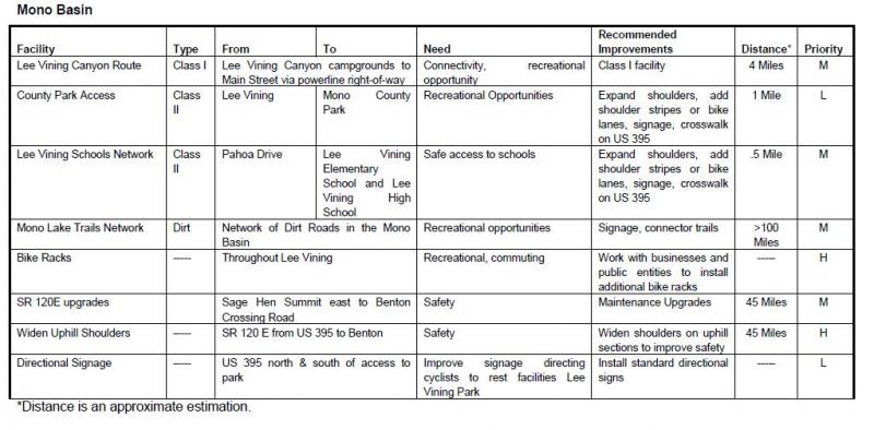
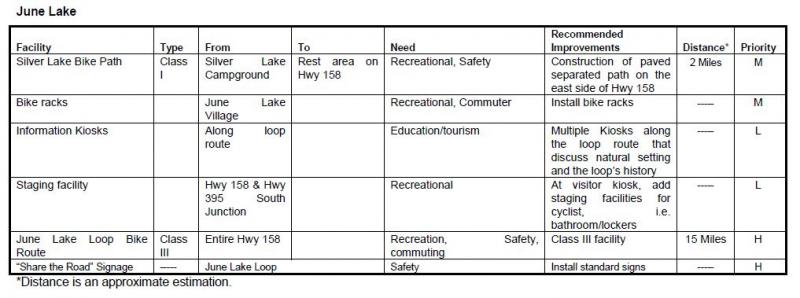

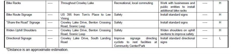
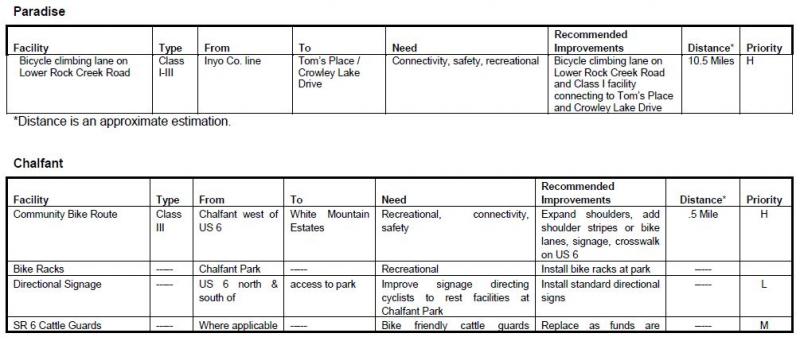
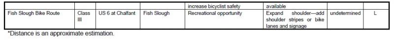
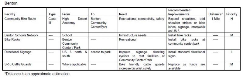
Chapter 6: Funding, Implementation, and Phasing
Estimated Project Costs
The Inyo County 2007/2008 Collaborative Bikeways Plan contains estimated costs for developing different types of bikeways. Those estimates will be utilized in this plan since development conditions are similar in the two counties. Some facilities may also be developed as regional facilities that are located in more than one county.
The Inyo County 2007/2008 Collaborative Bikeways Plan notes that:
These cost estimates are based on costs experienced in other California communities, recent cost estimates developed as part of traffic impact fee and mitigation analysis, and previous bikeway planning projects in the County of Yuba, City of Roseville, and City of Oakdale. The cost estimates include engineering, permitting, right-of-way, construction and inspection costs. These cost estimates should be used only to develop generalized construction cost estimates and project prioritization. More detailed estimates can be developed after preliminary engineering and design.
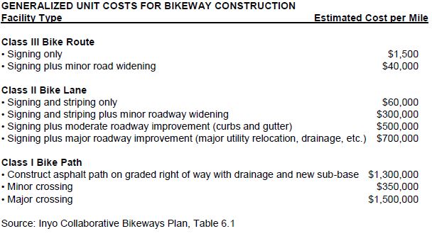
The unit costs identified in the above table have been applied to the proposed bikeway system. A summary of total system costs by facility type is presented in the table below.
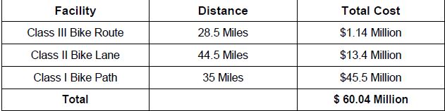
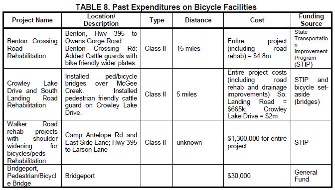
Funding Sources
Funding for bikeways and associated facilities is available from a number of federal and state programs. This section summarizes each of those sources. Generally, the local jurisdiction is responsible for applying for the funding identified below. Cooperative efforts among local agencies, such as the Forest Service, the County, and other local entities have been successful in obtaining funding for Mono County projects. It is important to note that many of these programs provide funding for the construction of bicycle facilities but not for on-going maintenance.
Federal Sources
Regional Surface Transportation Program (RSTP) – LTC, Caltrans
Provides funds for transportation projects on systems funded by federal-aid (functionally classified higher than local road or rural minor collector). Funds are available for bicycle and pedestrian facilities, transportation enhancement activities, and parking facilities (commuting and recreational programs).
Federal Safe Routes to Schools – Caltrans
For projects that connect schools and provide safe access for students (safety/education projects).
Recreational Trails Program – California Department of Parks & Recreation
For recreational trails to benefit bicyclists, pedestrians, and other users (recreational projects).
Transportation and Community and System Preservation Pilot Program – Federal Highway Administration
For projects that improve system efficiency and reduce the environmental impacts of transportation (commuting projects).
Land and Water Conservation Fund – California Dept. of Parks & Recreation
Projects that acquire and develop outdoor recreation areas and facilities (recreation projects).
State Sources
Safe Routes to School (SB 10) -- Caltrans
Provides funds for commuting, recreational use, and safety/education. Primarily intended for construction projects to enhance safety of pedestrian and bicycle facilities (commuting, recreation, safety/education projects).
Bicycle Transportation Account (BTA) -- Caltrans
Local jurisdictions must have a "Bicycle Transportation Plan" approved by CalTrans to submit applications. Project must conform to requirements of Caltrans Highway Design Manual, Chapter 1000. Intended for projects that improve the safety and convenience of bicycle commuters (commuting, safety/education projects).
Regional Transportation Improvement Program (RTIP) -- LTC
The local component of the State Transportation Improvement Program (STIP), the main transportation project funding source in the state. Projects must improve transportation within the region (commuting, safety/education projects).
Community Based Transportation Planning Demonstration Grant Program – Caltrans
For projects that exemplify livable community concepts (commuting projects).
Office of Traffic Safety Grants – Caltrans
May provide funds for bicycle and pedestrian projects (safety/education projects).
Active Transportation Program (ATP) – LTC, Caltrans
The ATP consolidates existing federal and state transportation programs, including the Transportation Alternatives Program (TAP), Bicycle Transportation Account (BTA), and State Safe Routes to School (SR2S), into a single program with a focus to make California a national leader in active transportation.
Other Sources
Funding may also be available from local agencies and private organizations. Recent cooperation between the U.S. Forest Service and the community of Lee Vining resulted in the construction of the Lee Vining community trail, and a local snowmobile enthusiasts groups have helped develop signed snowmobile trails on public lands.
In addition, it may be possible to obtain assistance from local groups and businesses in the construction and maintenance of bikeway facilities through a sponsorship program similar to the Adopt-A-Highway program implemented by Caltrans. For construction projects, assistance could be cash or the donation of goods and/or services; for maintenance activities, assistance may come from the donation of goods and/or services.
Appendix A: References
References Consulted
Bureau of Land Management (BLM)
Resource Management Plan for the Bishop Resource Area. 1991.
California Department of Transportation (Caltrans)
Highway Design Manual, Chapter 1000, Bikeway Planning and Design, 1/4/07.
Transportation Funding in California. 2007.
California Employment Development Department (EDD), Labor Market Information Division (LMID)
Mono County Profile. 2009.
Fehr and Peers, Transportation Consultants
Inyo County Collaborative Bikeways Plan. 2008.
Mono County Local Transportation Commission (LTC)
Mono County Regional Transportation Plan (RTP). 2008.
Mono County Planning Division
Mono County General Plan. 1993.
Mono County General Plan, Revised Land Use Element and Land Development Regulations. 2001.
Mono County Housing Element Update. 2009.
Mono County Master Environmental Assessment. 2001.
Mono County Trails Plan. 1994.
U.S. Forest Service (USFS)
Inyo National Forest Land and Resource Management Plan. 1988
Internet Reference Sites
The current internet address at the time of printing is listed for these sources; the address may have since changed.
California Department of Transportation (Caltrans)
Eastern Sierra Bicycle Guide, other Caltrans transportation planning documents.
California Department of Finance (DOF)
Demographic Research Unit, population and socio-economic statistics and forecasts, California Statistical Abstract.
Eastern Sierra Transit Authority (ESTA)
Information on transit services in the Eastern Sierra.
www.easternsierratransitauthority.com
Eastside Velo
Information on cycling in the Eastern Sierra.
Employment Development Department (EDD)
Labor market information, socioeconomic data, income and poverty statistics (Countywide level), occupational employment statistics.
www.labormarketinfo.edd.ca.gov
Sierra Cycling Foundation
Information on cycling in the Eastern Sierra.
www.sierracyclingfoundation.org
Town of Mammoth Lakes
Programs and policies in Mammoth Lakes.
U.S. Census Bureau
Population, housing, economic and social data from the 2000 Census, 5-year Economic Census, and other studies.
Utu Utu Gwaitu Paiute Tribe (Benton Paiute Reservation)
Information on tribal programs
www.bentonpaiutereservation.com
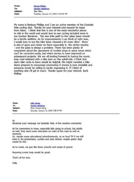
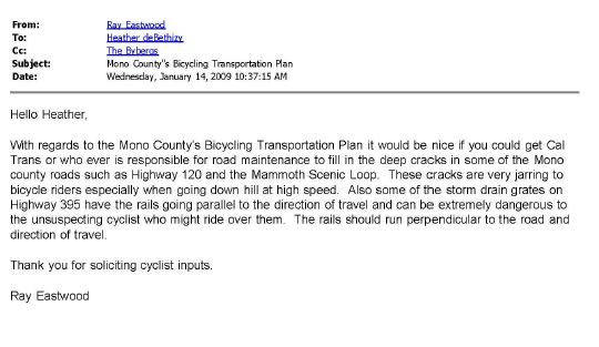
Appendix C: Maps
| Figure | Location/Area | Page |
| 3 | Antelope Valley | p54 |
| 4 | Bridgeport Valley/Twin Lakes | p55 |
| 5 | Bridgeport Community | p56 |
| 6 | Lee Vining Community | p57 |
| 7 | June Lake Loop | p58 |
| 8 | Long Valley | p59 |
| 9 | Benton Community | p60 |
FIGURE 3. Antelope Valley Bike Facilities Map
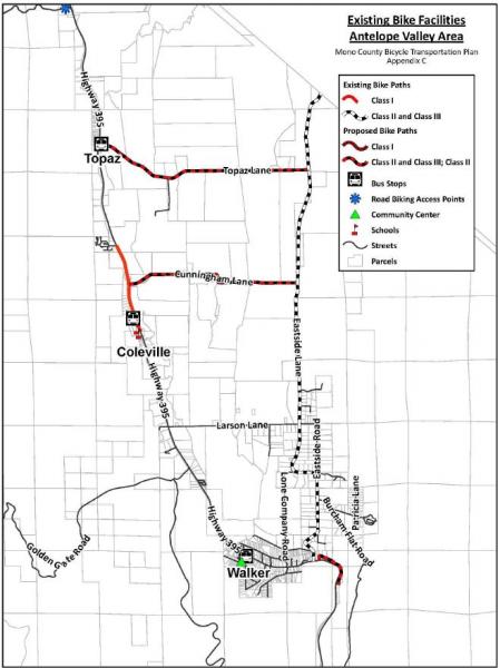
FIGURE 4. Bridgeport Valley/Twin Lakes Bike Facilities Map
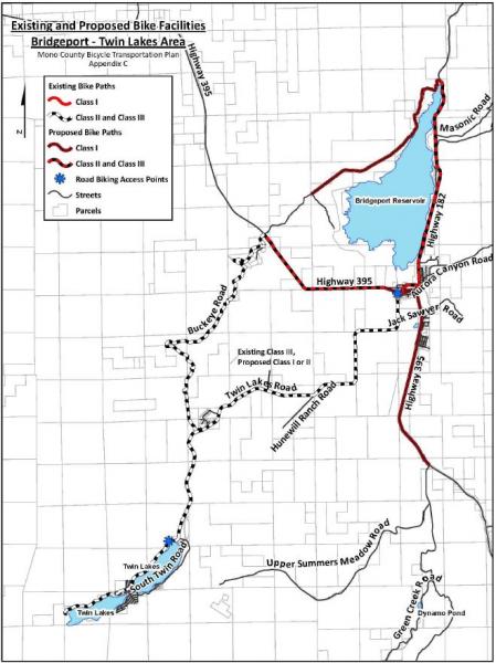
FIGURE 5. Bridgeport Community Bike Facilities Map
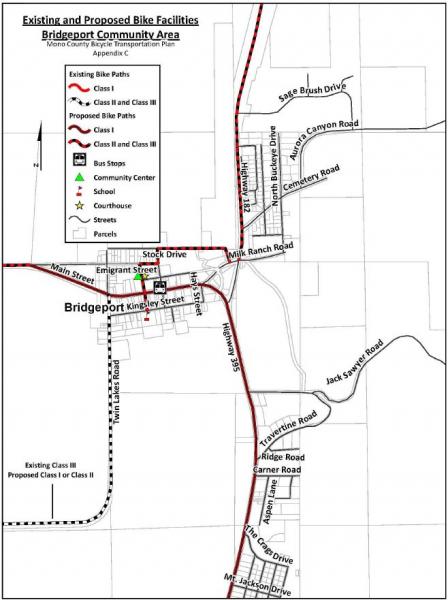
FIGURE 6. Lee Vining Community Bike Facilities Map
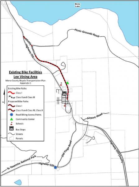
FIGURE 7. June Lake Loop Bike Facilities Map
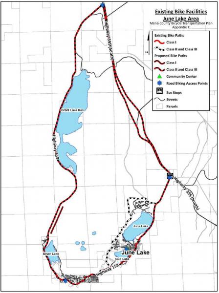
FIGURE 8. Long Valley Bike Facilities Map
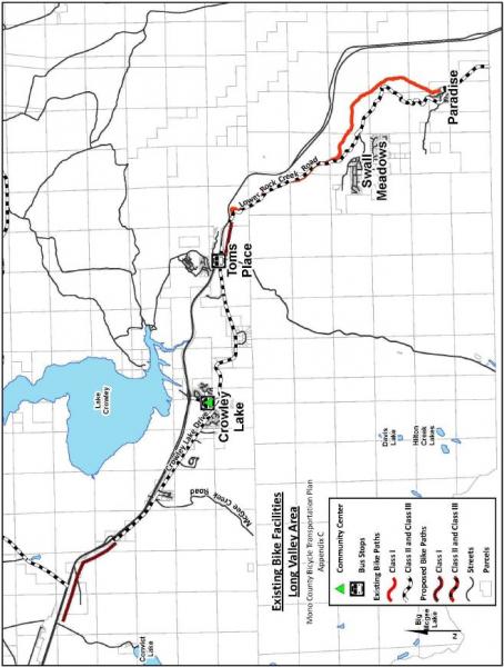
FIGURE 9. Benton Community Bike Facilities Map
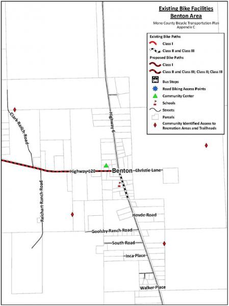
[1]Via searches on the American Fact Finder (U.S. Census website) at http://factfinder.census.gov/faces/nav/jsf/pages/index.xhtml and at http://factfinder.census.gov/faces/tableservices/jsf/pages/productview.x...
04-01 Introduction
In response to California’s critical housing needs, the Legislature enacted housing element law with the goal of providing adequate and safe housing for every Californian. The attainment of housing for all requires the cooperation of local and state governments.
Housing element law requires local governments to adequately plan to meet their existing and projected housing needs including their share of the regional housing need. Housing element law is the state’s primary market-based strategy to increase housing supply. The law recognizes the most critical decisions regarding housing development occur at the local level within the context of the General Plan. In order for the private sector to adequately address housing needs and demand, local governments must adopt land use plans and regulatory schemes that provide opportunities for, and do not unduly constrain, housing development for all income groups.
Unlike the other mandatory elements of the General Plan, the Housing Element is subject to detailed statutory requirements regarding its content and must be updated every five years. The Housing Element is also subject to mandatory review by the California Department of Housing and Community Development (HCD). This reflects the statutory recognition that the availability of housing is a matter of statewide importance and that cooperation between all levels of government and the private sector is critical to attainment of the state’s housing goals.
A. PUBLIC PARTICIPATION PROCESS
The initial draft of the 2014 Housing Element Update was prepared by the Mono County Community Development Department. Housing issues and concerns for the unincorporated area were identified through ongoing discussions with the County's nine community and Regional Planning Advisory Committees (RPACs), which include a variety of local residents and local representatives from local, state, and federal agencies Based on comments received at those meetings, the existing Housing Element Policies were reviewed for consistency with community comments. Comments from those meetings are included in the summary of conclusions section and have been addressed throughout the element.
Attempts were made to contact Hispanic community directly through the RPACs but there are currently no Hispanic groups active in the county.
The Collaborative Planning Team also reviewed the County’s housing policies. The Collaborative Planning Team is a multi-agency planning team, consisting of local, state, and federal agencies, which focuses on a variety of planning and resource use issues in the Eastern Sierra. Members include Mono County, the Town of Mammoth Lakes, the Bureau of Land Management, the Lahontan Regional Water Quality Control Board, the California Department of Fish and Game, Caltrans, the Los Angeles Department of Water and Power, the Inyo National Forest, the Humboldt-Toiyabe National Forest, the Benton Paiute Reservation, and the Bridgeport Indian Colony.
The draft update will be circulated to local agencies and organizations that provide housing- related services in the county, including:
Eastern Sierra Agency on Aging (ESAA), Bishop, California;
Inyo Mono Advocates for Community Action (IMACA), Bishop, California;
Inyo Mono Association for the Handicapped (IMAH), Bishop, California;
Kern Regional Center, Bishop, California;
Mammoth Lakes Housing, Mammoth Lakes, California; and
Mono County Department of Social Services, Bridgeport, California.
Notice of the availability of the draft will also be provided through publication in the local newspaper and by posting at County offices and public libraries.
Both the Mono County Housing Authority and the Planning Commission have held public workshops to address housing issues and policies. After completion of the public participation and HCD review process, The Mono County Planning Commission will hold a public hearing on the Draft 2014 Housing Element Update, and the Board of Supervisors will be hold a final adoption hearing pending recommendation of the Planning Commission.
B. CONSISTENCY WITH THE GENERAL PLAN
Development in Mono County is affected by policies in the county's General Plan, by standards in the Mono County Land Development Regulations, by land use requirements imposed by other agencies, and by requirements of the Subdivision Map Act and the county's Subdivision Ordinance. The county's General Plan serves as a comprehensive, long-range plan for the development of the area. The location of housing is determined primarily by policies contained in the Land Use Element, which establish the amount and distribution of various land uses throughout the county. The Land Use Element also specifies the maximum allowable density for each residential General Plan designation.
In conformance with state law, the Mono County General Plan has been written to be internally consistent; the goals, objectives and policies of each element are intended to be consistent with those in other elements. The 2014 Housing Element Update was reviewed for consistency with the Land Use Element to determine if adequate sites are provided to allow for housing for all economic segments of the community. The Land Use Inventory shows that Mono County has more than adequate acreage to accommodate the housing needs projected by HCD in the Regional Housing Needs Plan prepared for the County.
The Housing Element was also reviewed for consistency with the Circulation and Conservation/Open Space Elements of the General Plan. In Mono County, the circulation system is well established, and there is little traffic congestion. When congestion does occur, it is not the result of residents’ commuting, but of recreational traffic at peak use periods or special events, combined with local use. Although the existing circulation system is generally adequate to provide for additional housing, the Circulation Element provides for improvements to the local transportation system that will allow for the continued development of housing.
Since 94% of the land in Mono County is publicly owned, and 90% is federally owned, much of Mono County remains open space. As a result, the provision of open space as a part of developed residential areas is not a particular concern in the county. Policies in both the Conservation/Open Space Element and the Land Use Element focus future development in existing community areas, providing additional open-space protection.
General Plan consistency for all elements, including the Housing Element, will be maintained through required annual progress reports that address comments and issues identified through the County's ongoing public participation processes, such as Regional Planning Advisory Committee (RPAC) meetings.
04-02 Housing Needs
A. AREA PROFILE
Mono County is located on the eastern side of the Sierra Nevada mountain range and is bordered to the east by the state of Nevada. Approximately 94% of the county's 3,103 square miles is publicly owned; as a result, tourism and recreation-oriented enterprises are the primary economic activity in the county. The major population center, and the county's only incorporated area, is the town of Mammoth Lakes. The remainder of the county's residents are scattered in small communities throughout the county.
Communities in the county include: Topaz, Coleville and Walker in the Antelope Valley; Bridgeport, the county seat, in the Bridgeport Valley; Mono City and Lee Vining in the Mono Basin; June Lake in the June Lake Loop; Long Valley, McGee Creek, Crowley Lake, Aspen Springs and Sunny Slopes in Long Valley; Swall Meadows and Paradise in the Wheeler Crest area; and Chalfant, Hammil and Benton in the Tri-Valley.
B. SOURCES FOR DEMOGRAPHIC & HOUSING DATA
The majority of the demographic and housing data in the following sections are from the U.S. Census 2010. The census data presented here are a synopsis of the data available from Census 2010. Complete census files can be found at http://factfinder.census.gov. Additional demographic and economic information was obtained from the California Department of Finance (www.dof.ca.gov), HCD, and the Mono County IT department.
C. CENSUS 2010
The 2010 census went to great efforts to reach every individual housing unit, however the census did not include the “long form” that in past census’ has provided much of the detailed demographic information. Starting in 2005, an annual survey, the American Community Survey (ACS), has been sent to a small sample population and replaced the traditional long form format. While promising to deliver much more accurate and timely demographic information in the future, due to the small population size of our communities, there is currently a large amount of error in the ACS data. This error will decrease over time, but portions of the 2010 ACS data are too unreliable and in this document, the 2000 census figures are retained when error in the 2010 ACS is assumed to be high.
Census Designated Place (CDP) A CDP is a concentration of population identified by the Census Bureau for statistical purposes. 89.3% of the population in the unincorporated county lives within one of the 15 CDPs identified in Mono County and therefore the CDP has replaced the use of census tracts/blocks for general demographic analysis.
A. POPULATION CHARACTERISTICS
B. POPULATION GROWTH
Population growth trends in Mono County and its only incorporated city, the Town of Mammoth Lakes, continue a long-term trend of steady growth that began around 1960 (Figure 1). The highest rate of growth occurred in the 1970s and 1990s. In the 1990s, the percentage of the County’s total population living in the town of Mammoth Lakes increased from 48% of the total population in 1990 to a majority 55% in 2000 and again increased up to 58% in 2010 (Figure 2). The California Department of Finance projects a modest population increase rate of .7% per year through 2013 (Table 1).
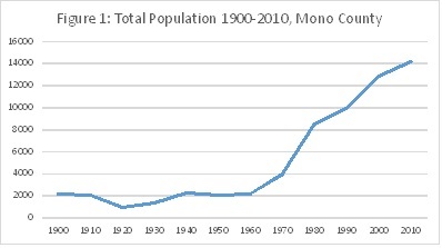
Source US CensusFigure 2: Town/County % of Total Population 1990-2010
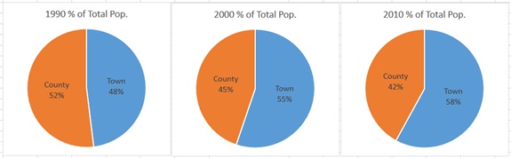
Source: US Census
Table 1: Population Trend, Unincorporated County
| Year | Population | % Change | Annual % |
|---|---|---|---|
| 1980 | 4460 | ||
| 1990 | 5171 | 15.9 | 1.6 |
| 2000 | 5759 | 11.4 | 1.1 |
| 2010 | 5968 | 3.6 | 0.4 |
| 2011 | 6103 | 2.2 | 2.2 |
| 2012 | 6144 | 0.7 | 0.7 |
| 2013 | 6186 | 0.7 |
0.7 |
Source: US Census, CA Dept. of Finance
Table 1.2: Population by CDP, 2010
| Total Population | % of Countywide Population | % of Countywide- Town | % of CDP Population | |
|---|---|---|---|---|
| Countywide | 14,202 | 100.0% | ||
| Mammoth Lakes | 8,234 | 58.0% | ||
| Countywide-Town | 5,968 | 42.0% | 100.0% | |
Mono County CDPs |
||||
| Crowley Lake | 875 | 6.2% | 14.7% | 16.4% |
| Walker | 721 | 5.1% | 12.1% | 13.5% |
| Chalfant | 651 | 4.6% | 10.9% | 12.2% |
| June Lake | 629 | 4.4% | 10.5% | 11.8% |
| Bridgeport | 575 | 4.0% | 9.6% | 10.8% |
| Coleville | 495 | 3.5% | 8.3% | 9.3% |
| Benton | 280 | 2.0% | 4.7% | 5.3% |
| Lee Vining | 222 | 1.6% | 3.7% | 4.2% |
| Swall Meadows | 220 | 1.5% | 3.7% | 4.1% |
| Sunny Slopes | 182 | 1.3% | 3.0% | 3.4% |
| Mono City | 172 | 1.2% | 2.9% | 3.2% |
| Paradise | 153 | 1.1% | 2.6% | 2.9% |
| Aspen Springs | 65 | 0.5% | 1.1% | 1.2% |
| Topaz | 50 | 0.4% | 0.8% | 0.9% |
| McGee Creek | 41 | 0.3% | 0.7% | 0.8% |
| Total of CDPs | 5,331 | 37.5% | 89.3% | 100.0% |
| CDPs + Town | 13,565 | 95.5% | ||
| County-CDPs & Town | 637 | 4.5% | 10.7% |
Table 2: Total Population Count by Race, CDP, Mono County 2010
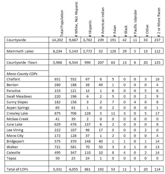
ETHNICITY
In the 1990 census, the ethnic composition of Mono County was predominantly white (93%), with 3.7% American Indian, <1% Black, 1.3% Asian, and 1.9% Other Race. Persons of Hispanic Origin, which includes people of all races, encompassed 11.3% of the population. In 2000, the population was 85.4% white, 4.8% American Indian, <1% Black, <1% Asian, <1% Pacific Islander, 6.0% Other Race, and 2.4% two or more races. While this seems a drop in the white population, it probably reflects more of a change in the way ethnicity was tabulated in the census data rather than a real change in the population. In 2010, the population was 76.1% white, 16.6% Hispanic, 3.5% American Indian, 2.1% 2 or more races, 1.1% Asian and less than .3% Black, Pacific Islander and Other Race (Table 2 & 3). The data shows a continued increase in the Hispanic population.
Table 3: Total Population Percentage by Race, CDP, Mono County 2010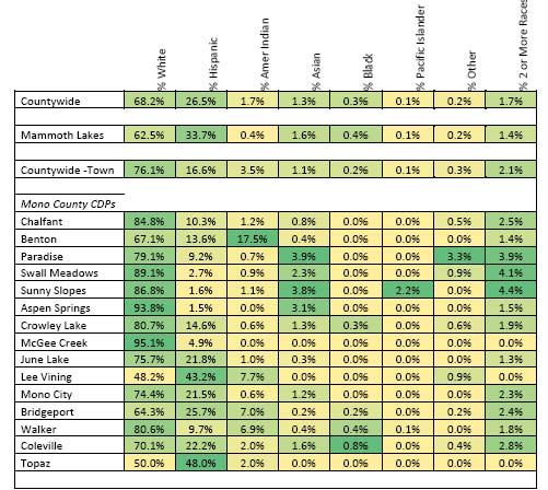
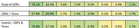
Source: US Census
The percentage of the population identifying themselves as Hispanic or Latino, of whatever race, increased in the unincorporated area, rising from 12.4% of the population in 2000 to 16.6% of the population in 2010 (Table 2 & 3), a numerical increase of 291 persons, from 699 in 2000 to 990 in 2010. During this same period, the Hispanic/Latino population in Mammoth Lakes increased from 22.2% of the town's population in 2000 to 33.7% of the town's population in 2010. The State Department of Finance is projecting that the Hispanic population in the county will rise dramatically over the next forty years, to 30% of the total County population in 2020 and 43% of the total in 2060 (see Table 4). Although Mammoth Lakes has a large Hispanic population, the rise in the Hispanic population could impact housing in the unincorporated area, as many of the Hispanic population tend to be lower-paid service workers in need of low to moderate-income housing.
Table 4: Projected Population by Race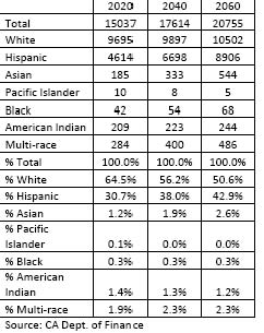
Source: CA Dept. of Finance
C. AGE
The median age in the unincorporated area is not officially calculated by the census bureau, however the average median age of the individual CDPs is 45.2, significantly older than the median age within the Town of Mammoth Lakes at 32.6. The number of seniors 65 years and older increased from 10% of the unincorporated population in 1990 to 12% in 2000, to 14.2 % in 2010. Coleville had the highest percentage of children under 18 presumably in the Marine Corps housing in Coleville. The Antelope Valley also had one of the highest percentages of seniors 65 years and older. The Long Valley/Wheeler Crest and Tri-Valley planning areas also had high percentages of children under 5 and seniors 65 years and older.
Table 5: Age Characteristics by CDP, 2010.
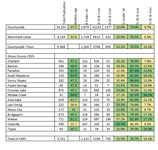
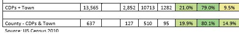
The State Department of Finance is projecting that the population in the county will age over the next twenty years, with the percent of the total County population that is elderly (65 years and over) rising from 14.2% in 2010 to 18.2% of the total in 2060 (see Table 10).
Table 6: Projected Population by Age
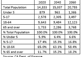
Source: CA Dept. of Finance
D. HOUSEHOLD CHARACTERISTICS
E. HOUSEHOLD SIZE
The 2010 census reports the total number of households in the unincorporated county to be 2,539 Average household countywide decreased slightly from 2.51 in 1990 to 2.42 in 2010 Coleville had the highest average household sizes, with 2.89 persons per household. McGee Creek and Paradise had the lowest average household sizes, with 1.95 persons/household and 2.07 persons per household, respectively (Table 7).
Table 7: Household Characteristics by CDP, 2010
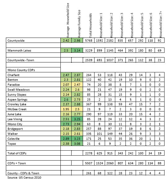
F. HOUSEHOLD TENURE
The overall number of renters in the unincorporated area decreased from 40% of all occupied units in 1990 to 32% 2010. The south county CDPs generally have very high rates of owner occupied units, the highest being Paradise at 95.9%. North county CDPs have higher renter occupied units with Coleville the highest at 71.9% due to the marine base housing. Vacant units, used as seasonal homes are widespread and make up 32.7% of all units in the unincorporated county. June Lake has the highest rate of seasonally vacant homes at 59.4%.
Table 8: Tenure of Occupied and Vacant Units by CDP, 2010.

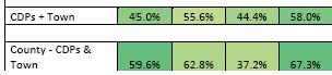
Source: US Census 2010
G. OVERCROWDED HOUSEHOLDS
The U.S. Census Bureau defines an overcrowded household as a housing unit occupied by more than one person per room (not including kitchens and bathrooms). Units with more than 1.51 persons per room are considered severely overcrowded and indicate a significant housing need. Overcrowding is not a significant housing situation in unincorporated Mono County. Using ACS data there were 47 overcrowded households, or 1.8% of the total households in the unincorporated area (Table 9). The statewide overcrowding rate for households in 2010 was 15.2% of all households, significantly higher than Mono County. Of the 47 overcrowded households, 57% were renters. This may indicate a disproportionate overcrowded situation for renters; however, overcrowded renter households represented only 2.5% of all renter households in the unincorporated area in 2010, significantly less than the statewide overcrowding rate for renters of 23.9% in 2010. Less than1% of all households in the unincorporated area were severely overcrowded in 2010. Of the 20 households identified as being severely overcrowded, 0 of them were owner households, all 20 were renter households.
Table 9: Overcrowded Households, 2011
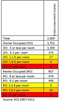
Source: ACS 2007-2011
H. EXTREMELY LOW-INCOME HOUSEHOLDS
Extremely low-income households are those with income less than 30% of the area’s median income. Mono County’s median income in 2013 was $79,600. Income limits are adjusted depending on the number of people in the household. For a four-person household, the current income limit for an extremely low-income household is $19,575. For a one-person household, the income limit is $13,725.
Households with extremely low income may have a variety of housing needs. In Mono County, households receiving assistance through the CalWORKS program, Supplemental Security Income (SSI), or disability income may be considered extremely low-income households. Mono County also has a large population of service workers earning minimum wage who may fall into the extremely low-income category, depending on the number of workers in a household. The California Economic Development Department provides Occupational Employment Statistics for the Eastern Sierra Region showing wages for a variety of occupations.
Table 10: Occupational Wage Data

Source: California Employment Development Department (EDD), Occupational Employment and Wage Data, Occupational Employment Statistics Survey.
Estimated data on the number of extremely-low income households in the county is available through the ACS. In 2011, there were approximately 442 extremely-low income households in the unincorporated area, 17.4% of the total number of households. This is a dramatic increase from 2000 when only 7.5% of households were considered extremely low income; however, this is likely due to the small sample size of the ACS. 37% of the extremely-low income households were renters; 63% were homeowners. Households are considered to be overpaying for housing if payments for rent or mortgage are 30% or more of household income. 96% of extremely low income renters pay over 30% of their income on housing costs.
Table 11: Extremely Low Income Households by Tenure, 2011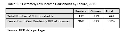
A. OVERALL EMPLOYMENT TRENDS
The following discussion of employment trends in Mono County is excerpted from Eastern Sierra Region Projection Highlights (Alpine, Inyo, and Mono Counties) prepared by the California Employment Development Department (www.labormarkerinfo.edd.ca.gov).
Industry
Total employment, including Self-Employment, Unpaid Family Workers, Farm Employment and Nonfarm Wage and Salary Employment in the Eastern Sierra Region is expected to grow about 1.6% annually between 2004 and 2014. Employment is anticipated to increase by almost 2,800 total jobs to about 20,200 jobs in 2014. The projected growth rate for this three-County area is equal to the growth rate of California, which is about 1.6% annually.
Nonfarm Wage and Salary Employment, which accounts for 91% of total employment, is expected to grow 1.7% annually for the next ten years in the Eastern Sierra Region. Six out of ten new jobs are forecasted to occur in Government (800), Leisure and Hospitality (440), and Retail Trade (380).
Occupations
Occupational projections for the period 2004 to 2014 forecast:
- 2,740 new jobs from industry growth,
- 4,620 jobs openings from Net Replacements,
- A combined total of 7,360 job openings.
The top 50 occupations with the most job openings will generate 65% of all job openings in the Eastern Sierra Region during the 2004-2014 projections period, accounting for almost 4,800 total job openings. Of the top 50 occupations with the most job openings, 41 require work experience or on-the-job training. Food preparation and Office and Administrative Support account for 18 of the 50 occupations with the most job openings.
The 32 fastest growing occupations are all expected to grow at an annual rate of 1.6% or more. Of the 32 fastest growing jobs, 27 require work experience or on-the-job training. There are seven occupations in Construction scattered throughout the top 32 fastest growing occupations.
B. EMPLOYMENT TRENDS UNINCORPORATED AREA
The Available ACS data for employment has a high margin of error (total estimated workforce is larger than the total unincorporated population), and while included in the following tables, data from the 2000 census or other sources was left in place as it is assumed to be of much higher accuracy.
Employment data for March, 2009 from the Employment Development Department and the 2011 ACS in parenthesis where applicable, show the following current employment by industry (not seasonally adjusted):
C. MAJOR EMPLOYERS IN MONO COUNTY
The following list of major employers in Mono County was developed using the 2009 America's Labor Market Information System Employer Database (California Employment Development Department, www.labormarketinfo.edd.ca.gov). Many of these employers are located in Mammoth Lakes, a significant commute from many areas of the county.
| Employer Name | Location | Industry |
| Eastern Sierra Unified School District | Various | Schools |
| June Mountain Ski Area | June Lake | Resort |
| Juniper Springs Resort | June Lake | Hotels & Motels |
| Mammoth Hospital | Mammoth Lakes | Hospitals |
| Mammoth Lakes Fire Department | Mammoth Lakes | Misc. Business |
| Mammoth Mountain Inn | Mammoth Lakes | Hotels & Motels |
| Mammoth Mountain Ski Area | Mammoth Lakes | Hotels & Motels |
| Mono County Government | Bridgeport | Local Government |
| Town of Mammoth Lakes government | Mammoth Lakes | Local |
| U.S. Forest Service | Various | Federal Government |
| Vons | Mammoth Lakes | Retail |
| Westin-Monache Resort | Mammoth Lakes | Hotels and Motels |
| 1990 | 2000 | 2011 ACS | ||||||
| Industry Type | # | % | # | % | %change | # | % | %change |
|
Agriculture, forestry, fishing and hunting and mining |
275 | 10.8% | 160 | 5.6% | -5.2% | (275) | (3.9%) | -1.79% |
| Construction | 389 | 15.3% | 449 | 15.8% | +.5% | (593) | (8.4%) | -7.49% |
| Manufacturing | 79 | 3.1% | 101 | 3.4% | +.3% | (179) | (2.5%) | -.9% |
| Wholesale trade | 25 | 0.9% | 0 | 0.0% | -.9% | (4) | (0.1%) | +.1% |
| Retail trade | 392 | 15.4% | 297 | 10.5% | -4.9% | (708) | (10%) | -.5% |
|
Transportation and warehousing, and utilities |
99 | 3.9% | 105 | 3.7% | -.2% | (205) | (2.9%) | |
| Information | 0 | 0.0% | 61 | 2.1% | +2.1% | (99) | (1.4%) | -.7% |
|
Finance, insurance, real estate and rental and leasing |
145 | 5.7% | 83 | 2.9% | -2.8% | (805) | (11.4%) | +8.5% |
|
Professional, scientific, management, administrative, and waste management services |
140 | 5.5% | 169 | 5.6% | +.1% | (617) | (8.7%) | +3.1% |
|
Educational, health and social services |
263 | 10.3% | 545 | 19.1% | +8.8% | (988) | (13.9%) | -5.2% |
|
Arts, entertainment, recreation, accommodation and food services |
393 | 15.5% | 549 | 19.3% | +4.8% | (2,043) | (28.8%) | +9.5% |
| Other Services | 84 | 3.3% | 75 | 2.6% | -.7% | (237) | (4.7%) | +2.1% |
| Public administration | 258 | 10.1% | 246 | 8.7% | -1.4% | (336) | (3.3%) | -5.49% |
| TOTAL | 2,542 | 100% | 2,840 | 100% | (7,089) | 100% |
Source: U.S. Census 1990, SF3:P077; U.S. Census 2000, SF3:P49
D. INCOME
The overall median household income in the unincorporated area based on the ACS 2008-2012 data was $61,868, up from $45,325 in 2000. The median household income varied significantly, however, throughout the county with the communities near Mammoth Lakes generally having higher overall income levels. The median household income based upon HCD income limits for Mono County in 2012 was $79,600.
Table 13: Household Income by CDP, 2012
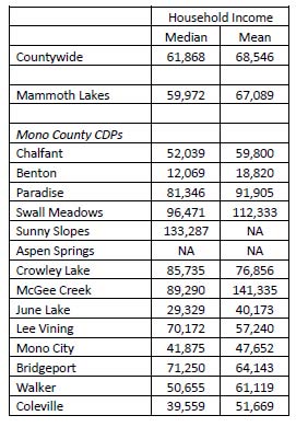

Source ACS, 2007-2012
E. POVERTY
The total number of persons with income below poverty level in the unincorporated area decreased from 563 in 1989 to 438 in 1999. During the same time period, the number of persons with income below poverty level decreased for all age groups, except 18-64 years old, which increased from 282 to 292 persons, and in all planning areas except June Lake, which increased from 30 to 39 persons and Long Valley/Wheeler Crest, which increased from 19 to 38 persons. ACS poverty data for Mono County has not yet been released from the 2008-2012 ACS data set.
Table 13.2: Persons with income below poverty level, 1989 and 1999
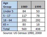
Source: US Census 1990, 2000
A. HOUSING TYPES
Housing in unincorporated Mono County is predominantly single-family detached units and mobile homes. Since 1990, all types of housing in the unincorporated area increased (Table 14). During that period, multifamily units had the greatest percentage increase, although a majority of that increase occurred from 1990-2000 and the rate has slowed considerably in the last decade.
Table 14: Housing Units by Type, Unincorporated Mono County, 1990-2010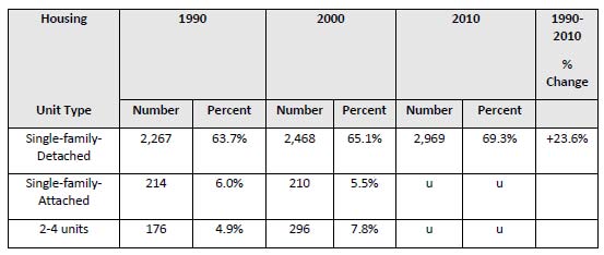
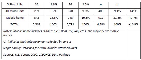
B. HOUSING STOCK CONDITIONS
The Mono County Community Development Department completed a comprehensive Housing Condition Survey for the unincorporated area of the county in the summer of 2009. The results of that survey are shown in Table 15; results are shown for conventional single family residences (SFR) as well as mobile homes (MH). The results have been aggregated by planning area. Data for smaller community areas within the planning areas is available from the Community Development Department.
Housing units determined to be in Good Condition were in overall good condition with no repair needed. Units determined to be in Fair Condition were structurally sound but needed some minimal repair and/or paint. Units determined to be in Poor Condition were not structurally sound and needed repairs and/or paint.
Table 15: Housing Stock Conditions by Planning Area, 2009.
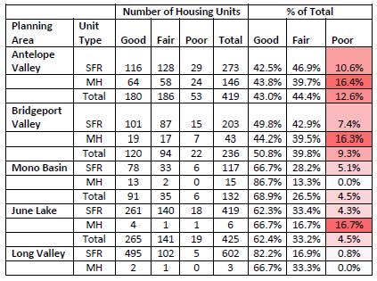
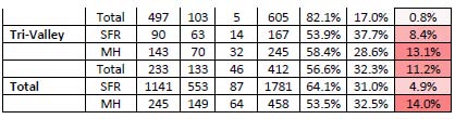
Source: Mono County Community Development Department, Housing Conditions Survey.
Approximately 39% of all housing units in the unincorporated area were built more than 30 years ago (Table 16). Twenty-one percent were built more than 40 years ago, and 13% were built more than 50 years ago (Table 16). Bridgeport Valley (65%) and Mono Basin (47%) have the highest percentage of housing units built more than 30 years ago, although over a third of the housing units in all planning areas except June Lake were built more than 30 years ago. Bridgeport Valley (33%), Mono Basin (22%), and Long Valley (22%) have the highest percentage of housing units built more than 40 years ago. Bridgeport Valley (22%), June Lake (14%), and Long Valley (14%) have the highest percentage of housing units built more than 50 years ago.
Table 16: Age of Housing by Planning Area, Mono County, 2000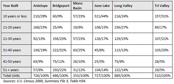
Sources: U.S. Census 2000, Summary File 3, Table H34
In Long Valley and June Lake many of the housing units built more than 40 years ago were originally constructed as seasonal cabins.
In general, Mono County's housing stock is in fair to good condition. Approximately 60% of all housing units in the unincorporated area have been built in the past 30 years. There are areas in the county, however, where maintenance and rehabilitation of the housing stock is an issue. Funding is available from the CDBG Rehabilitation Loan Program. Specific programs provide funds for single-family home repair loans and emergency repair. Over the years, many of those units have been converted to year-round housing. In Bridgeport Valley and Mono Basin, many of the older housing units were constructed as primary residences and have been maintained and accessibility grants, exterior enhancement rebates, weatherization and home security grants for seniors, and a multifamily rehabilitation loan program.
A. PERSONS WITH DISABILITIES
While persons with disabilities do not represent a significant portion of the population in the unincorporated area of the county, adequate housing remains an important concern. In 2010, a total of 861 persons had a disability, approximately a quarter of whom (249 persons, Table 34) were not employed, and approximately one quarter were over the age of 65 (222 persons, Table 35).
The Inyo Mono Association for the Handicapped (IMAH) serves disabled adults 18 and older, primarily with vocational training, supported employment and similar programs. The Inyo Mono Area Agency on Aging (IMAAA) contracts with the Mono County Department of Social Services to provide Mono County Senior Services (MCSS). IMAAA also operates the Linkages program in Mono County, which links vulnerable seniors and disabled adults to service in order to enhance their ability to maintain their independence. Mono County Senior Services (MCSS) delivers meals to 28 homes in Walker and serves 15 to 25 meals a day in the Walker Senior Center while 9 to 10 meals a day are delivered to the Benton area seniors. MCSS also has 3 clients under the Linkages Program and 28 under In Home Supportive Services (IHSS) to assist those clients in remaining in their homes. Other than the above, the Mono County Department of Social Services does not maintain information on how many people with disabilities they may assist. Social Services provides the following resources to people in need: CalWORKS, General Assistance, Food Stamps, Medi-Cal and/or CMSP.
Kern Regional Center serves disabled clients from Pearsonville in Kern County to Topaz in Mono County. Due to the size of its service area (16,000 square miles) and the relatively small number of clients (158 people), its services are prescriptive in nature and needs are addressed on an individual basis. They assist clients with adapting their homes and installing assistive devices but do not deal directly with housing.
The Inyo Mono Advocates for Community Action (IMACA) provide a variety of services for disabled, low-income, and homeless persons in Inyo and Mono counties. In unincorporated Mono County, IMACA provides help with retrofit programs (wheelchair ramps, assistive devices, etc.), home weatherization programs for low-income persons, child care, Head Start, and meals. It operates 25 low-income housing units in Mammoth Lakes as well as senior and low-income housing units in Inyo County. IMACA has Section 8 vouchers that it uses primarily for rental assistance and shelter for homeless persons.
Table 17: Persons with Disability by Employment Status, Unincorporated Mono County| Number | Percent | |
| Age 16-64, Employed Persons with a Disability | 385 | 61.7% |
| Age 16-64, Not Employed Persons with a Disability | 113 | 18.1% |
| Persons Age 65 Plus with a Disability | 126 | 20.2% |
| Total Persons over 15 with a Disability | 624 | 100% |
| % of Total Population | 5,197 | 12.0% |
Source: Census Bureau (2000 Census SF 3: P42Table 18: Persons with Disabilities by Disability Type, Unincorporated Mono County
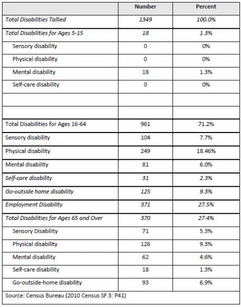 .
.
B. ELDERLY
The elderly are defined as those 65 years and older. The 2010 Census reported that 845 seniors reside in unincorporated Mono County, 14.2% of the total population. The home ownership rate of seniors is very high, 95.7% in 2000. In addition, only 18 seniors had incomes under the poverty level in 1999. Home ownership is a significant hedge against the inflationary rental environment, which is probably why there are few seniors at or below the poverty level.
Site and unit size availability are generally not a problem for seniors in Mono County, due to the fact that Mono County is a rural area with the propensity for lot subdivisions rather than home subdivisions and the fact that mobile homes are permitted throughout the county on parcels zoned for single-family residences.
Due to the low number of poverty-level senior residents within the county, future needs for low-income senior households can best be addressed through rehabilitation assistance for homeowners and rent assistance for low- and moderate-income senior renters. Currently, there is no rental-assisted housing in the unincorporated areas. IMACA operates 19 units of senior housing in Bishop. Mammoth Lakes Housing operates rental-assisted housing in Mammoth Lakes, as well as low-income housing to own.
Section 202 financing, Direct Loans for Housing for the Senior or Handicapped, administered by the Department of Housing and Urban Development, is also available to qualified sponsors for the financing of construction of rental or cooperative housing facilities for occupancy by senior or handicapped persons.
C. LARGE HOUSEHOLDS & OVERCROWDING
Large households are defined as households with more than five persons. When the housing market does not meet large household housing needs, overcrowding can result. Overcrowding is not a significant housing situation in the unincorporated area of Mono County The ACS survey estimates 47 households are overcrowded with 20 of those being severely overcrowded or 173 households were reported to be have over 5 occupants. Large households (five or more persons) are located throughout the county but predominantly in Antelope Valley, Long Valley and Tri-Valley, these areas have large numbers of children and teenagers.
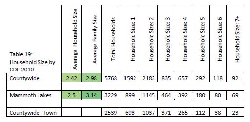

D. FARMWORKERS
While the acreage in farms in Mono County declined between 1997 and 2007, from 68,813 acres to 44,610 acres, the number of farms increased from 63 to 84. The average size of farms decreased from 1,092 acres to 531 acres; hired farm labor decreased from 121 farmworkers on 26 farms to an undisclosed number of workers on 22 farms (Table 20 and USDA, 1997 and 2007 Census of Agriculture). Much of the census information on the number of workers is undisclosed, making it difficult to estimate the total number of farmworkers in the county. The census does indicate that 7 farms with 25 workers reported only permanent workers, 11 farms with 39 workers reported only seasonal workers, and 4 farms with an undisclosed number of workers reported utilizing both permanent and seasonal workers. Due to federal funding limitations, an updated Census of Agriculture has not been released.
Large farm owners and ranchers in the Antelope, Bridgeport and Hammil valleys hire a limited number of farmworkers and ranch hands. Housing for most of these employees is provided on site. If this type of housing were to be eliminated, it would be difficult for farm laborers to find adequate affordable housing. The 2010 Census indicates that when the census was taken, there were 17 vacant units categorized as “migratory.” This does not indicate how many total units were available for farmworkers.
Table 20: Number of Farmworkers (2007) Mono County

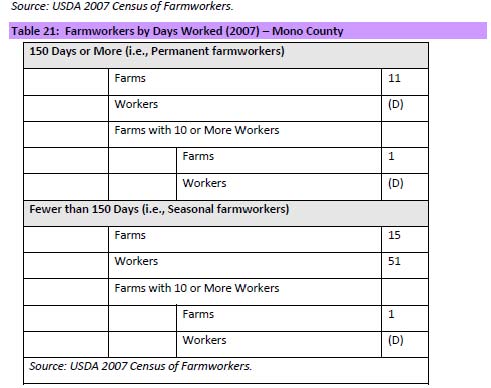
E. FEMALE-HEADED HOUSEHOLDS
The Census provides data on the total number of female-headed households, the number of those with children, and the number with incomes below the poverty level. The data are not provided separately by owner and renter and include all female heads of household; those without children may be supporting parents, or a single parent may be supporting an adult child or relative. This data is now collected by the ACS. Female heads of household are often the households most in need of affordable housing, childcare, job training and housing rehabilitation funds.
In unincorporated Mono County, there were 145 female-headed households in 2011 (5.7% of all households), up from 137 in 2000 Of the 145 female-headed households, according to the ACS data 0 were under the poverty level however, it is likely that the ACS is underreporting due to a small sample size
The Mono County Department of Social Services estimates that approximately 45 families in the unincorporated area with a female head of household receive assistance from CalWorks on an ongoing basis (Julie Timerman). Under this program they are eligible to receive food stamps and Medi-Cal, as well as Welfare to Work services including, but not limited to, mental health, drug and alcohol counseling, child care, and job skills. There are no direct housing assistance programs.
Female headed households with an income under the poverty level will need affordable rental housing. In Mono County, mobile homes and small multifamily units such as duplexes and triplexes, are often the most affordable.
Table 22: Female Headed Households (2011) Unincorporated Mono County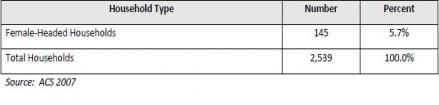
Source: ACS 2007
F. EMERGENCY SHELTER NEEDS AND HOMELESS HOUSING
The need for emergency housing encompasses a large range of situations. Families otherwise able to provide themselves with adequate housing may be suddenly and unexpectedly faced with the need for emergency shelter as a result of fire or family break-up. Families only marginally able to meet their housing needs may be left without shelter when their present housing is sold, when a shared housing arrangement breaks down, from an inability to pay rent, or a number of similar reasons. Finally, there is a transient population, composed of both families and individuals that may have emergency shelter needs.
Mono County does not have a large homeless population, largely due to the severe winter weather conditions. The Mono County Department of Social Services estimates that they have approximately one homeless assistance case per year, usually a family displaced for a short time each year (Julie Timerman). Mono County does not have any homeless shelters, due to the low numbers of homeless persons. In addition, the social services that are provided are not concentrated in one location, making it difficult for a homeless person to utilize them, especially since there is only limited public transportation within the county.
Through the joint efforts of the Mono County Department of Social Services and the Inyo-Mono Advocates for Community Action (IMACA) low-income residents and transients in Mono County may be placed in a local or nearby motel on an emergency basis for up to 28 days. IMACA has 18 Section 8 vouchers that they use primarily for rental assistance and shelter for homeless persons. IMACA also operates 24 units of low-income housing in Mammoth Lakes. The Mono County Department of Social Services provides rental assistance to assist individuals with permanent housing or to keep them from being evicted, and provides food vouchers to qualified persons. Current services are adequate for the needs in the area.
In compliance with state law, the county will designate at least one land use designation where emergency shelters and transitional and supportive housing for the homeless will be allowed without a use permit or other discretionary permit. Emergency shelters will be allowed in the Public Facility (PF) land use designation and multi-family residential designations (MFR). Currently, the county has designated its community centers as emergency shelters for disaster/weather-related shelter needs. Community centers are located in the PF land use designation. As shown in Table 48, the County has a large amount of land designated with various MFR designations, with sufficient capacity to accommodate the need for emergency shelters. In compliance with state law, transitional and supportive housing will be allowed as a residential use in all land use designations where similar housing types are allowed. Transitional and supportive housing must be subject only to the restrictions that apply to other residential uses of the same type in the same designation.
Emergency housing may also be a necessity during times of disaster, such as avalanches, floods, fires and earthquakes. According to the Mono County Multi-Hazard Functional Plan, prepared by the county's Office of Emergency Services, emergency housing may consist of any appropriate public or private building, depending on the size, location and nature of the disaster. Currently, each community area in Mono County has a designated Emergency Shelter, usually the community center or a church or school. Disaster shelters may be temporarily coordinated and/or funded by the American Red Cross, the Federal Emergency Management Agency, the local Department of Social Services, the Sheriff's Department, and other appropriate private or quasi-public organizations. Although the California Office of Emergency Services has suggested that a permanent, year-round emergency disaster shelter may be appropriate for Mono County, the cost of building such a facility is well beyond the reach of the County's budget. Until such time as additional funding becomes available, use of community centers, federal buildings, churches and hotels/motels as evacuation centers/emergency shelters will continue in Mono County.
G. U.S. MARINE CORPS
The Marine Corps Mountain Warfare Training Center, located off SR 108 west of Sonora Junction and north of Bridgeport, maintains housing on the base and at Coleville in the Antelope Valley. There are 110 housing units at the family housing project north of Coleville in the Antelope Valley, and one barrack at the base with 200 beds for single people.
A. REGIONAL HOUSING NEED
The Regional Housing Need allocated to unincorporated Mono County for the period January 1, 2014 through June 30, 2019 is shown in Table 23. The income groups are defined as follows:
Very Low Income = 0-50% of the area's median income (AMI)
Low Income = 51-80% of the area's median income
Moderate Income = 81-120% of the area's median income
Above Moderate Income = Over 120% of the area's median income
The median income for Mono County in 2013 was $79,600 (HCD, 2013 income limits). Income limits are adjusted depending on the number of people in the household.
Table 23: Regional Housing Needs, Unincorporated Mono County, 2014-2019| Income Group | Number | Percent |
|---|---|---|
| Extremely Low | 5 units | 11% |
| Very Low | 6 units | 13% |
| Low | 7 units | 15% |
| Moderate | 9 units | 20% |
| Above Moderate | 19 units | 41% |
| Total | 46 units | 100.0% |
Source: HCD
The Regional Housing Need allocated to the County by HCD included 11 units for Very Low-Income households. However, Chapter 891, Statutes of 2006, requires the quantification and analysis of existing and projected housing needs for Extremely Low-Income (ELI) households. ELI is a subset of the very low-income group and is defined as 30% and below of the area’s median income. To calculate projected ELI housing needs, the County assumed that 50% of its very low-income regional housing needs are extremely low-income households. As a result, from the very low-income need of 6 allocated by HCD, the County has projected a need of 5 units for extremely low-income households.
Previously, Mono County allocated its overall regional housing needs to communities in the unincorporated area based on the percentage of the population in each community area. Due to concerns in some communities over the arbitrary nature of such an allocation, the County has decided to no longer allocate its regional housing needs to community areas. To address community concerns about the placement of housing for low- and very low-income households in community areas, the County has amended a program in the Housing Element to require the County to utilize a variety of factors, including current and projected population figures, economic conditions, transportation systems, the potential for rehabilitation, and the availability of utilities and infrastructure, when considering the placement of affordable housing throughout the county.
Table 24 shows the number of housing units by income group permitted in the unincorporated portion of Mono County between January 2007 and December 2013, based on actual sales prices, type of construction and size of the units constructed.
Table 24: Units Constructed or Approved, Unincorporated Mono County, 2007-2013| Income Group | # of Units Constructed | # of Units Approved |
|---|---|---|
| Extremely Low | 0 | 0 |
| Very Low | 1 | 0 |
| Low | 12 | 36 |
| Moderate | 30 | 0 |
| Above Moderate | 83 | 0 |
| Total | 126 | 36 |
Source: Mono County Community Development Department.
Table 25 shows the progress Mono County has made during 2007-2013 in meeting its regional housing need and the number of units still required in each income group to meet its identified regional housing need for the planning period.
Table 25: Progress toward the Regional Housing Need, Unincorporated Mono County, 2007-2013| Income Group | Regional Housing Need | Units Constructed | Remaining Housing Need |
|---|---|---|---|
| Extremely Low | 29 units | 0 | 29 |
| Very Low | 30 units | 1 | 29 |
| Low | 59 units | 12 | 47 |
| Moderate | 58 units | 30 | 28 |
| Above Moderate | 116 units | 83 | 33 |
| Total | 292 units | 126 | 166 |
Sources: Mono County Community Development Dept, HCD- Regional Housing Need Plan.
B. QUANTIFIED OBJECTIVES
Table 26 presents Mono County's quantified housing objectives for the planning period. Housing starts have continued to be very slow. During the early 2000s, the county experienced explosive growth in new residential construction, meeting much of the County's identified regional housing need by new construction. Over the past seven years, housing starts have dropped dramatically from a high of nearly 80 units in 2005 to averaging only 13 units per year for the past five years. The County has approved several large subdivisions during the previous period that will fulfill part of the regional needs for moderate to above moderate housing.
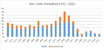
The rehabilitation objectives reflect rehabilitation efforts in community areas. The conservation and preservation objectives reflect ongoing conservation efforts such as weatherization programs.
Table 26: Quantified Objectives| Income Group | New Construction | Rehabilitation |
Conservation and Preservation |
|---|---|---|---|
| Extremely Low (5) | 3 | 2 | --- |
| Very Low (6) | 3 | 2 | 1 |
| Low (7) | 3 | 2 | 2 |
| Moderate (9) | 9 | 0 | 0 |
| Above Moderate (19) | 19 | 0 | 0 |
|
Total |
37 | 6 | 3 |
Source: Mono County Community Development Department.
04-03 Resources and Constraints
A. PHYSICAL AND ENVIRONMENTAL CONSTRAINTS
There are areas within Mono County that are unavailable for residential development because of site constraints such as natural hazards or environmentally sensitive lands. The high cost of building on these lands, coupled with environmental constraints, in many cases would make them unsuitable for development.
Development in the following areas may be prohibited by the county's General Plan and/or Land Development Regulations or by requirements of other state or federal agencies, may present a hazard to those who choose to build in the area, or may impact valuable resources and require costly mitigation measures:
- Remote Locations. Some privately owned undeveloped land in Mono County is located in very remote areas where there is not, nor is there expected to be, demand for development. Reasonable legal access to these lands cannot be developed or acquired, and most of the time the County would not be able to provide the normal, expected, public services of police and fire protection, schools, etc. Most of the land in remote areas is not designated for residential use because of its remoteness. It is generally designated Resource Management or Agriculture and is used either for grazing or crops. Many of these lands are pockets of privately owned land surrounded by public lands managed by the U.S. Forest Service or the Bureau of Land Management. In addition, the Los Angeles Department of Water and Power, technically a private landowner, owns land throughout the central and southern portion of the county. Most of the land in remote locations would not be developable for other reasons as well, such as hazards associated with the area or environmentally sensitive lands in those areas. The remote location of some private land is generally not a constraint to development since most of the private land base is centered on existing community areas.
- Hazard-Prone Areas. Mono County currently regulates development in snow avalanche-prone areas as well as in areas identified as Alquist-Priolo Special Studies Zones (fault hazard zones), in other geologically sensitive areas, and in flood plains. Mono County General Plan policies (Safety Element) limit development in identified hazardous areas in order to minimize the risks of those hazards and to protect local communities from unreasonable risks associated with those hazards. General Plan policies also promote land exchanges for those lands to place them in public ownership and make other lands adjacent to community areas available for future community expansion.
Snow avalanche-prone areas are located in Twin Lakes, June Lake and Wheeler Crest, along the edges of those communities. Sufficient other sites are available for development in those communities so that the avalanche-prone areas do not affect development potential significantly.
Alquist-Priolo Special Studies Zones (fault hazard zones) occur throughout the county, many of them outside community areas. General Plan policies limit the intensity of development in seismic and other geologic hazard areas and require applicable development in those areas to provide a geotechnical report assessing the risk and recommending mitigation measures to reduce the risk to acceptable levels. The Building Division also requires new construction to comply with engineering and design requirements for seismic safety. The impact of fault hazard zones on new development is not significant. Other geologic hazards, such as rockfalls and landslides, are generally associated with seismic activity and are subject to the same development requirements noted above.
Mono County uses the FEMA flood maps to identify areas within the 100-year flood plain. General Plan policies limit the intensity of development in the flood plain and regulate the placement of structures in the 100-year flood plain. The county's Floodplain Regulations (Mono County Land Development Regulations, Chapter 21) contain standards for construction and for subdivisions with the flood plain. Flooding is a particular concern in the Antelope Valley and the Tri-Valley. There is enough land in community areas that avoidance of flood plains does not significantly affect the County's ability to provide housing.
- Soils with Low Permeability Rates. Many parts of the county are not served by public sewer systems and must rely on septic systems. In some parts of the county, standard septic systems cannot be used because the soils have low permeability rates that prevent effective operation of septic tank systems. This is a very limited issue that affects only a small number of parcels. Alternative septic system designs are available and, while they may be more costly, they do allow the site to be developed.
- Environmentally Sensitive Areas. Development is regulated in wetland areas, within stream corridors, in sensitive wildlife habitat, and in other environmentally sensitive areas. Environmentally sensitive areas occur throughout the county. Typically, parcels are large enough that the environmentally sensitive area can be avoided and the parcel can still be utilized for development. Parcels with environmentally sensitive areas usually require CEQA review of any proposed projects; during the CEQA review process, the project will be redesigned to avoid environmental impacts, and mitigation measures will be proposed to minimize impacts that cannot be avoided. Mono County General Plan policies encourage clustering on large parcels outside community areas in order to preserve habitat and avoid and/or minimize environmental impacts.
B. ZONING FOR LOWER-INCOME HOUSING
Mono County has several land use designations that specifically provide density bonuses for affordable housing and that are intended to provide for the efficient use of land and to increase opportunities for affordable housing. The following land use designations promote the provision of affordable housing:
Multiple-Family Residential – Low, Moderate, and High (MFR-L, M, H)
The MFR-L designation is intended to provide for low-density multifamily residential development such as duplexes and triplexes. The MFR-M designation is intended to encourage long-term multifamily housing by allowing for higher population densities and by not allowing commercial lodging facilities; i.e., hotels, motels. The MFR-H designation is intended to encourage multifamily units by allowing for higher population densities and to provide for commercial lodging facilities: i.e., hotels, motels.
All of the designations allow duplexes and triplexes. All of the designations allow condominiums, cooperatives, townhomes, cluster developments, and apartments containing four or more units subject to Use Permit. The MFR-H designation also allows mobile-home parks subject to Use Permit.
Density bonuses are available in the MFR-M and MFR-H designations for affordable housing. The MFR-M also provides a bonus for enclosed, covered parking. In no case shall projects containing affordable housing and/or enclosed, covered parking density bonuses exceed 26 units/acre.
- Density bonuses are available to residential projects at a rate of 35% over the maximum density or a ratio of one bonus unit to one affordable/employee housing unit, whichever is greater. Density bonuses will be awarded in a manner consistent with Government Code Section 65915.
- Units designated as manager/employee housing unit shall not be counted in density calculations.
- Density bonuses for enclosed, covered parking are available at a rate of one bonus dwelling unit per two enclosed, covered parking spaces. Projects must provide enclosed, covered parking for at least 50% of the units to qualify for bonuses. Density bonuses would be calculated on the surplus of required covered parking spaces greater than 50%.
Mixed Use (MU)
The MU designation is intended to provide for a wide range of compatible resident- and visitor- oriented residential and commercial uses, including business, professional, and retail uses; to provide for efficient use of land and increased opportunities for affordable housing; to provide a transition between intensive commercial uses and residential uses; and to be applied to areas with existing mixed use development. MU transitional areas can limit the size of business establishments and restrict uses incompatible with residential districts. Not all areas need contain residential uses. Commercial uses shall conform to strict standards that prohibit obnoxious odors, obtrusive light and glare, and excessive noise.
The MU designation allows duplexes and triplexes. Condominiums, townhomes, and apartments are allowed subject to Director Review permit. Mobile-home parks are allowed subject to Use Permit.
An additional lot coverage bonus of 10% (total coverage of 70%) shall be granted to structures that contain mixed commercial and residential (employee or long-term rentals) uses; commercial uses with public accommodations; or commercial uses that front a public pedestrian mall or plaza.
Density bonuses are available for affordable housing and enclosed, covered parking. In no case shall projects containing affordable housing and/or parking density bonuses exceed 26 units per acre for residential units and 60 units per acre for commercial lodging units.
- Density bonuses are available to residential and commercial lodging projects at a rate of 35% over the maximum density or a ratio of one bonus unit to one affordable/employee housing unit, whichever is greater. Density bonuses will be awarded in a manner consistent with Government Code Section 65915.
- Units designated as manager/employee housing unit shall not be counted in density calculations.
- Density bonuses for enclosed, covered parking are available at a rate of one bonus dwelling unit per two covered parking spaces. Projects must provide enclosed, covered parking for at least 50% of the units to qualify for bonuses. Density bonuses would be calculated on the surplus of required covered parking spaces greater than 50%.
Commercial Lodging – Moderate, High (CL-M, H)
The CL-M designation is intended to provide commercial lodging units for short-term occupation in or near residential uses. The CL-H designation is intended to provide short-term commercial lodging units in close proximity to commercial/recreational centers.
Duplexes and triplexes are allowed in both designations. Mobile-home parks, condominiums, cooperatives, townhomes, cluster developments, and apartments containing four or more units are allowed in both designations subject to Use Permit.
Density bonuses are available for affordable housing and enclosed, covered parking. In no case shall projects containing affordable housing and/or parking density bonuses exceed 26 units/acre for residential units and 60 units per acre for commercial lodging units in the CL-H.
- Density bonuses are available to residential and commercial lodging projects at a rate of 35% over the maximum density or a ratio of one bonus unit to one affordable/employee housing unit, whichever is greater. Density bonuses will be awarded in a manner consistent with Government Code Section 65915.
- Units designated as manager/employee housing unit shall not be counted in density calculations.
- Density bonuses for enclosed, covered parking are available at a rate of one bonus dwelling unit per two enclosed, covered parking spaces. Projects must provide enclosed, covered parking for at least 50% of the units to qualify for bonuses. Density bonuses would be calculated on the surplus of required covered parking spaces greater than 50%.
In addition to the above, the Mono County Housing Mitigation Requirements (Mono County Code, Chapter 15.40) provide for density bonus incentives pursuant to the California Density Bonus Law for any project that meets the criteria set forth in Government Code Section 65915. The Housing Mitigation Requirements also allow the County to consider an additional density bonus upon request of the developer when such request can be accommodated within the parameters of the Mono County general plan or any applicable specific plan.
Mono County also has several land use designations that allow for the use of a mobile home as a single-family residence, provided that the mobile home is newer than 10 years old and meets other specified requirements. The following land use designations allow mobile homes to be used as single-family residences:
Estate Residential (ER) – minimum parcel size 1 acre
Rural Residential (RR) – minimum parcel size 1 acre
Rural Mobile Home (RMH) – minimum parcel size 1 acre
Single-family Residential (SFR) – minimum parcel size 7,500 square feet
Lands designated SFR are generally in community areas. Lands designated ER, RR, and RMH are generally in more rural areas, outside community areas, where land may be less expensive.
C. AVAILABILITY OF INFRASTRUCTURE TO IDENTIFIED LANDS
Much of the land available for residential development in the unincorporated area requires individual septic systems and wells. Some areas of the county have small community water systems but still require individual septic systems; other areas have community sewer systems but require individual wells. There is sufficient capacity in the community water and sewer systems and sufficient groundwater resources and percolation capabilities outside of community water/sewer system areas to accommodate the regional housing need allocation.
| Antelope Valley | Individual wells and septic systems required. |
| Bridgeport Valley | Community water within community of Bridgeport and Evans Tract with adequate capacity. Community sewer system within Bridgeport with adequate capacity. Individual systems required elsewhere. |
| Mono City | Mutual water company supplies water; individual septic systems required. |
| Virginia Lakes | Mutual water company supplies water; individual septic systems required. |
| Lee Vining | Community water and sewer system with adquate capacity. Individual system required in the rest of Mono Basin. |
| June Lake | Community water and sewer system, currently with adquate capacity. Large developments may be required to make improvements to the water distribution system that is currently inadquate in some areas of the community. |
| Long Valley | Community sewer system in Crowley; septic systems elsewhere. Mutual water companies in Crowley and Sunny Slopes; individual wells elsewhere. |
| Wheeler Crest | Mutual water company at Rimrock; individual wells elsewhere. Individual septic system required. |
| Paradise | Mutual water company at Paradise. Individual septic systems required. |
| Tri-Valley | Mutual water companies in White Mountain Estates, Osage Ranch; individual wells elsewhere. Individual septic systems required. |
| Outside Community areas | Individuals wells and septic systems required. Community systems may be required for large developments (subdivisions, specific plan developments). |
Water quality requirements affect both community water and sewer systems and individual homeowners. Lahontan Regional Water Quality Control Board's (RWQCB) water quality regulations affect the minimum lot size on which development can occur depending on whether community water and/or sewer systems are available; i.e.,
Community water and sewer available – no minimum lot size established by RWQCB;
Community water available, individual septic required – 20,000 square foot minimum lot size required by RQWCB;
No community systems available, individual wells and septic required – 40,000 square foot minimum lot size required by RWQCB; and
Minimum lot sizes in cluster subdivisions or similar developments not served by a public sewer system may be reduced if density standards for the whole subdivision are not increased above the gross density specified in the designation, provided that all other health requirements are met.
In some areas in the county where individual lots are 7,500 square feet, these requirements make it necessary to have more than one lot to build a house. Some areas of the county also have soils that are not conducive to standard septic system designs. Those areas may require additional septic system improvements that increase the cost of building.
The lack of improved roads throughout the county also affects the potential for development. The main thoroughfares in the county are US 395, US 6 and State Routes 120, 158, 167, 108, and 89. Each of the community areas has a road system; some of these roads are improved, some are not. Some roads in community areas are included in the County road system; some are not. Those that are not are often unimproved. Outside community areas, numerous single-lane and two-lane dirt and gravel roads exist as a result of mining and logging activity. Many of these roads are used by off-road vehicles.
Economic concerns focus on the need for development projects to "pay their own way" and on the need to provide for local economic growth. Most of the services and infrastructure in the county are provided either by the County or local special districts. All of these agencies have been hard hit by lower property tax revenues and increasing service demands. The County must ensure that development does not adversely impact service agencies.
D. REDEVELOPABLE SITES
Mono County has sufficient undeveloped sites available to meet its identified regional housing needs. Regardless, particularly in the community of Lee Vining there may be some opportunity to provide additional housing from the redevelopment of existing county and state road maintenance yards that are located centrally within the community. The exploration of these complex projects is supported by several housing programs.
E. SITES & ZONING THAT FACILITATE HOUSING FOR FARMWORKERS & HOMELESS
The Agriculture (AG) designation allows farm labor housing without any type of development permit, other than a building permit. The Scenic Area Agriculture (SAA) designation also allows farm labor housing without any type of development permit, other than a building permit, to the extent the development complies with the Mono Basin National Forest Scenic Area Private Property Development Guidelines and with the Compatibility Determinations for Proposed New Commercial Uses and Developments. Compatibility determinations are based upon recommendations of the U.S. Forest Service.
The SAA designation applies to only four acres within the Mono Basin National Forest Scenic Area. The AG designation applies to 79,156 acres throughout the county, primarily in Antelope Valley, Bridgeport Valley, and Tri-Valley. The minimum parcel size for the AG designation is set at 2.5 acres but actually varies by area. Minimum parcel sizes and densities are established by land use designation maps and policies for the Antelope Valley, Bridgeport Valley, and Tri-Valley. There is a ten-acre minimum in Antelope Valley. Bridgeport Valley and Tri-Valley utilize a transfer of development rights program that allows for more concentrated development in small areas while maintaining large areas in agricultural uses.
There are no specific development standards for farmworker housing; it is subject to the same development standards as other housing. Farmworker housing is not a significant issue in Mono County. There is sufficient appropriately zoned land to provide additional farmworker housing; there is nothing in the Mono County Land Development Regulations that impedes the development of farmworker housing.
F. SITES INVENTORY AND ANALYSIS
The County’s share of the regional housing need for the planning period is a total of 46 housing units, allocated to specific income groups as follows:
Extremely Low Income Units = 5 units
Very Low Income Units = 6 units
Low Income Units = 7 units
Moderate Income Units = 9 units
Above Moderate Income Units = 19 units
Government Code Sections 65583 and 65583.2 require a parcel-specific inventory of appropriately zoned, available, and suitable sites that can provide realistic opportunities for the provision of housing to all income segments within the community.
Although the County’s regional housing need is in the process of being met through a variety of ongoing development (units built since the beginning of the Regional Housing Needs Allocation period, second units, available and appropriately zoned land), to ensure that there are adequate sites in the unincorporated area of the county to meet the identified housing needs, the sites inventory identifies vacant sites that are appropriately zoned to allow for multi-family residential development, that have the available infrastructure, and that are without site constraints. The following tables indicate total assumed build-out of each vacant parcel with land use designation MFR, C & MU. The maps included in this analysis indicate all parcels in the communities with the Land Use Designations of MFR, C and parcels with the designation of SP likely to include affordable housing as Specific Plans are developed. The most recent planning effort at the SP designated parcel in June Lake indicated on the map included the development of approximately 65 affordable housing units, the most recent planning effort for the parcels indicated on the countywide map near the community of Lee Vining included the development of approximately 30 affordable housing units. Many underutilized parcels also exist, however an analysis of these parcels was determined to be unnecessary as the vacant sites provide more than adequate capacity.
Table 27: Bridgeport| Parcel APN | LUD | Acres |
Realistic Units @ Build Out |
| 8091007000 | MFR-L | 0.61 | 7 |
| 8091034000 | MFR-L | 0.18 | 2 |
| 8091039000 | MFR-L | 0.18 | 2 |
| 11040044000 | MU | 4.67 | 70 |
| 11301003000 | MU | 0.55 | 8 |
| 11301004000 | MU | 0.55 | 8 |
| 11030007000 | MU | 10.30 | 154 |
| 11291006000 | MU | 0.83 | 12 |
| 8132011000 | MFR-L | 0.34 | 4 |
| 8141011000 | C | 0.17 | 2 |
| 8132038000 | C | 0.17 | 2 |
| 8133034000 | MFR-L | 1.03 | 11 |
| 8102011000 | C | 0.26 | 3 |
| 8093031000 | MFR-L | 0.26 | 3 |
| 8211008000 | MU | 0.24 | 3 |
| 8211001000 | MU | 0.36 | 5 |
| 8220032000 | MFR-M | 0.25 | 3 |
| 8213014000 | MU | 0.31 | 4 |
| 8091024000 | MFR-L | 0.18 | 2 |
| 8091032000 | MFR-L | 0.19 | 2 |
| 8091043000 | MFR-L | 0.31 | 3 |
| 8091041000 | MFR-L | 0.18 | 2 |
| 8213010000 | MU | 0.18 | 2 |
| 8070035000 | MU | 0.23 | 3 |
| 8091035000 | MFR-L | 0.33 | 3 |
| 11301002000 | MU | 0.55 | 8 |
| 11301005000 | MU | 0.55 | 8 |
| 8133032000 | MFR-L | 0.66 | 7 |
| 8133039000 | MFR-L | 0.48 | 5 |
| 8133027000 | MFR-L | 0.84 | 9 |
| 8141008000 | C | 0.21 | 3 |
| 8142008000 | C | 0.06 | 1 |
| 8133028000 | MFR-L | 0.08 | 1 |
| 8134015000 | C | 0.17 | 2 |
| 8134009000 | C | 0.08 | 1 |
| 8142024000 | C | 0.24 | 3 |
| 8132037000 | C | 0.19 | 2 |
| 8142020000 | C | 0.14 | 3 |
| 8092003000 | C | 0.67 | 9 |
| 8102015000 | C | 0.09 | 1 |
| 8131012000 | C | 0.45 | 6 |
| 8102013000 | C | 0.23 | 3 |
| 8102014000 | C | 0.09 | 1 |
| 8092007000 | MFR-L | 0.28 | 3 |
| 8093026000 | C | 0.23 | 3 |
| 8092008000 | MFR-L | 0.24 | 2 |
| 8211010000 | MU | 0.29 | 4 |
| 8213012000 | MU | 0.73 | 10 |
| 8211002000 | MU | 0.27 | 4 |
| 8211003000 | MU | 0.27 | 4 |
| 8212008000 | MFR-M | 0.24 | 3 |
| 8212007000 | MFR-M | 0.28 | 4 |
| 8210002000 | MFR-M | 0.26 | 3 |
| 8210006000 | MFR-M | 0.41 | 6 |
| 8091046000 | MFR-L | 0.17 | 2 |
| 8211006000 | MU | 0.23 | 3 |
| TOTAL | 32.60 | 444 |
Table 28: June Lake
| Parcel APN | LUD | Acres |
Realistic Units @ Build Out |
| 16192014000 | MFR-L | 0.18 | 2 |
| 16192013000 | MFR-L | 0.18 | 2 |
| 16217036000 | MFR-L | 0.18 | 2 |
| 16217039000 | MFR-L | 0.17 | 2 |
| 16217033000 | MFR-L | 0.18 | 2 |
| 16217038000 | MFR-L | 0.17 | 2 |
| 16217040000 | MFR-L | 0.17 | 2 |
| 16217027000 | MFR-L | 0.18 | 2 |
| 16217029000 | MFR-L | 0.17 | 2 |
| 16217032000 | MFR-L | 0.18 | 2 |
| 16217031000 | MFR-L | 0.18 | 2 |
| 16217028000 | MFR-L | 0.18 | 2 |
| 16193025000 | C | 0.37 | 5 |
| 16216030000 | MFR-L | 0.25 | 2 |
| 15086021000 | C | 0.10 | 1 |
| 16217030000 | MFR-L | 0.18 | 2 |
| 15086018000 | C | 0.17 | 2 |
| 15072015000 | MU | 0.24 | 3 |
| 15075016000 | C | 0.18 | 2 |
| 15075015000 | C | 0.11 | 1 |
| 15075020000 | C | 0.13 | 1 |
| 15075021000 | C | 0.12 | 1 |
| 15075014000 | C | 0.11 | 1 |
| 15073026000 | MFR-H | 0.24 | 3 |
| 15075010000 | C | 0.11 | 1 |
| 15075018000 | C | 0.11 | 1 |
| 15072016000 | MU | 0.25 | 3 |
| 15075019000 | C | 0.11 | 1 |
| 15075017000 | C | 0.13 | 1 |
| 15111029000 | MU | 0.23 | 3 |
| 15111027000 | MU | 0.23 | 3 |
| 15111028000 | MU | 0.23 | 3 |
| 15111014000 | MU | 0.11 | 3 |
| 15072017000 | MU | 0.38 | 5 |
| 15113025000 | C | 0.12 | 1 |
| 15112032000 | MU | 0.14 | 0 |
| 15112017000 | MU | 0.11 | 3 |
| 15112019000 | MU | 0.11 | 3 |
| 15112006000 | MU | 0.11 | 3 |
| 15112011000 | MU | 0.11 | 3 |
| 15113010000 | C | 0.11 | 1 |
| 15113013000 | MU | 0.11 | 3 |
| 15104050000 | MFR-H | 0.05 | 1 |
| 15103018000 | MFR-H | 0.23 | 3 |
| 15113014000 | C | 0.17 | 2 |
| 15113070000 | MU | 0.23 | 3 |
| 15113054000 | C | 0.15 | 2 |
| 15113042000 | MU | 0.11 | 3 |
| 15103021000 | MFR-H | 0.03 | 1 |
| 15104041000 | MFR-H | 0.72 | 10 |
| 15104047000 | MU | 0.33 | 4 |
| 15103022000 | MFR-H | 0.43 | 6 |
| 15104046000 | MFR-H | 0.48 | 7 |
| 15103020000 | MFR-H | 0.04 | 1 |
| 15104043000 | C | 0.02 | 0 |
| 15086037000 | C | 0.23 | 3 |
| 16217034000 | MFR-L | 0.19 | 2 |
| 16217024000 | MFR-L | 0.29 | 3 |
| 10.86 | 140 |
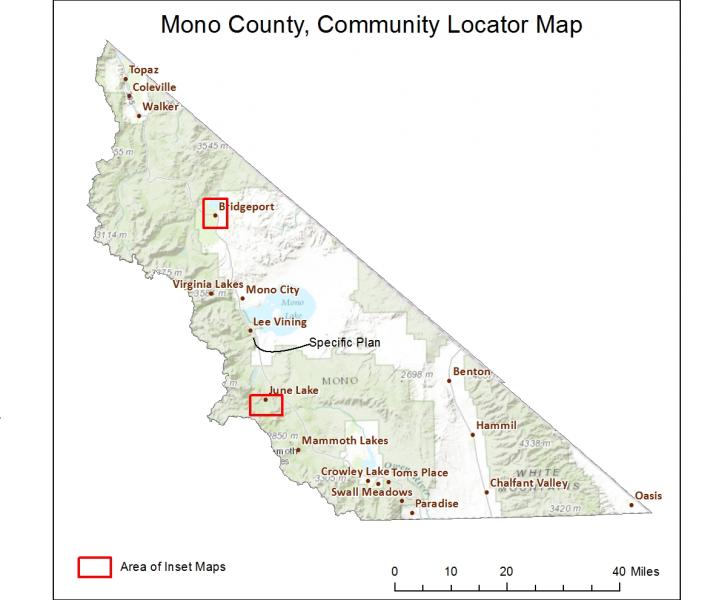
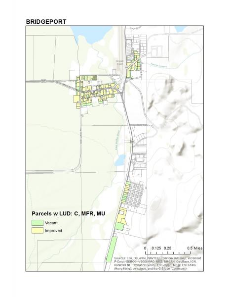
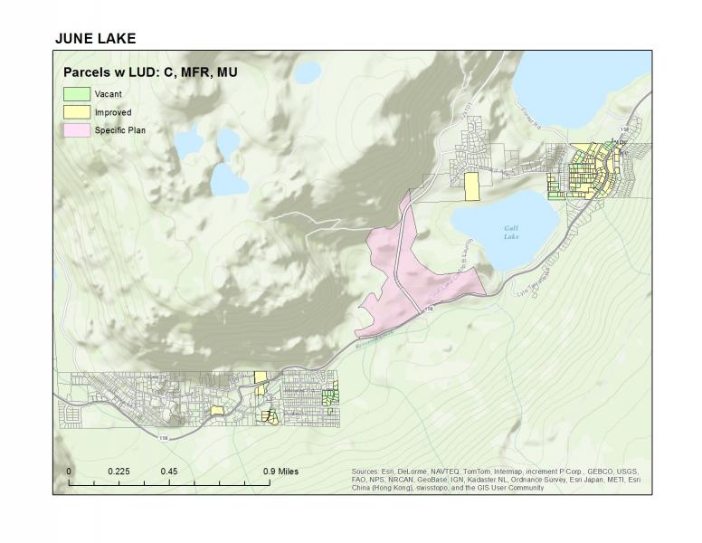
B. GOVERNMENTAL CONSTRAINTS
a. LAND USE CONTROLS
Mono County's Land Use Designations and Land Development Regulations, which are integrated into the Mono County Land Use Element, provide for residential development throughout the unincorporated portion of the county (Table 48). The Land Use Designations contain development standards for each of the land use designations; general standards that pertain to all development are contained in the Land Development Regulations. The County does not have separate zoning regulations.
Mono County's land use designations permit single-family residential development, including mobile homes, in almost all designations within developed community areas and in rural areas. Multifamily residential development is permitted in multifamily, mixed use, commercial, and commercial lodging area designations, primarily in developed community areas. The county's Land Use Element, including the Land Development Regulations, does not contain any growth-control measures.
Secondary housing units are permitted in several land use designations subject to ministerial review and meeting development requirements in the Land Development Regulations. Mobile homes have been identified as an affordable housing type in Mono County and are permitted as single-family residences in many land use designations throughout the county (Table 48). Mobile-home parks are permitted in a number of designations, subject to a Use Permit and meeting state requirements for mobile-home parks.
Development of agricultural lands is determined by policies in the Mono County Land Use Element intended to preserve agricultural uses, to protect agricultural uses from the encroachment of incompatible land uses, while allowing for the continuation of agricultural production and the development of limited housing. The minimum parcel size for agricultural land is 2.5 acres but actually varies by area. Minimum parcel sizes and densities are established on the County's land use maps. The minimum parcel size for agricultural lands in the Antelope Valley is 10 acres. Development of agricultural lands in the Bridgeport Valley, the Bodie Hills, and the Hammil Valley is subject to a Transfer of Development Rights program established for each of those areas. Potential development is clustered to preserve agricultural uses. Larger parcel sizes and lower densities on agricultural lands have not been identified as a constraint to development in Mono County because there is sufficient land elsewhere to meet identified needs.
Residential development standards for residential land use designations are illustrated in Table 30 & 31 Reductions in several standards are allowed in certain situations; e.g., density bonuses are available in multifamily, mixed use, and commercial lodging designations for projects that provide affordable housing and/or enclosed, covered parking (from 15 dwelling units per acre to 26 units per acre). Lot coverage in the mixed use designation may be increased from 60% to 70% if the development includes residential and commercial uses. Other standards also promote higher-density housing in commercial, mixed use, and commercial lodging designations; e.g., C, MU, and CL designations have a zero side yard setback unless the site abuts a residential district. The maximum building residential building height may be increased from 35 feet to 45 feet if side and rear setbacks are also increased, allowing larger size housing units to meet the needs of large households.
Table 30: Housing Types Permitted by Land Use Designation|
Housing Types Permitted |
RR | ER | RMH | SFR | MFR-L | MFR-M | MFR-H | MU | CL-M | CL-H | RU | C | SC |
| Single-family dwelling | P | P | P | P | P | P | P | P | P | P | p | p*** | P*** |
| Mobile Home | P | P | P | P | P | --- | --- | P* | p | ||||
| Secondary unit | P1 | P1 | P1 | P1 | --- | --- | --- | p1 | |||||
| Mobile-home park | UP | UP | UP | UP | --- | --- | UP | UP | UP | UP | |||
| Duplexes and triplexes | P | P | P | P | P | P | p*** | p*** | |||||
| Condominiums, townhomes, apartments with 4+ units | UP | UP | UP | DR | UP | UP | UP*** | UP*** | |||||
| Social care facilities | UP | DR | |||||||||||
| Transisent rentals (less than 30 consecutive days) of 4+ units | OD | OD | OD | OD | UP | UP** | UP** | ||||||
| Conversion of 5 or more apartment units into transient rentals | UP | UP | |||||||||||
| Group homes, juvenile facilities, schools and similar facilities | |||||||||||||
| Farm labor housing | |||||||||||||
| Farm labor trailer parks | |||||||||||||
| Employee housing | UP | ||||||||||||
| Emergency Shelters |
|
Notes: P= Permitted Use, D= Permitted Subject to Director Review permit, UP= Permitted Subject to Conditional Use 1. Small units permitted outright, larger units may require DR or UP depending on parcel size. *except in June Lake ** transient rentals up to 3 days permitted with Director Review permit. *** when found compatible with the intent of the commercial designation. **** attached secondary units. ***** limited density when found compatible with the area by the planning commisions. Transitional and Supportive Housing are permitted in that same manner as other residential dwellings fo the same type. Source: Mono County General Plan, Land Use Element, Land Use Designations |
02.1070 Social care facility. "Social care facility" means any facility in the general classification of a boarding home for aged persons, boarding home for children, day care home for children, day nursery, nursing home or parent-child boarding home. These facilities consist of a building or group of buildings used or designed for the housing of sick, demented, injured, convalescent, infirm or well, normal healthy persons, requiring licensing or certification by regulating government agencies.
02.1210 Transient Rental. "Transient Rental" means any structure, or portion of structure, which is occupied, or intended or designed for occupancy by transients for purposes of sleeping, lodging or similar reasons. A "transient" is any person who exercises occupancy, whether by agreement, concession, permit, right of access, license, contract, and payment of rent or otherwise, for a period of thirty (30) consecutive calendar days or less.
02.1215 Transitional Housing. “Transitional Housing” means a type of supportive housing used to facilitate the movement of homeless individuals and families to permanent housing.
02.1165 Supportive Housing. “Supportive Housing” means permanent rental housing linked to a range of support services designed to enable residents to maintain stable housing and lead fuller lives.
Table 31: Residential Development Standards by Land Use Designation| Development Standards | RR | ER | RMH | SFR | MFR-L | MU | CL-M | CL-H |
RU |
||
| Minimum lot area | 1 ac | 1 ac | 1 ac | 7,500 sf |
sfr/duplex -7,500 sf mfr- 11,250 sf condos- 20,000 sf |
10,000 sf (<10,000 sf- sfr & duplex) condos- 20,000 sf |
10,000 sf (<10,000 sf- sfr, duplex, triplex) condos- 20,000 sf
|
10,000 sf (10,000 sf- sfr, duplex, triplex) |
5 acres | ||
| Minimum district area | 5 acres | 5 acres | 5 acres | 5 acres | --- | 3 acres | 5 acres | 5 acres | 3 acres | 5 acres | --- |
| Lot dimensions | Every lot shall have a minimum width and depth of not less than 60 feet by 100 feet unless otherwise specified in land use designation. The lot depth shall not exceed 3 times the lot width, unless the lot is 10 gross acres or larger in size, then a ratio of 4 to 1 is acceptable. | ||||||||||
| Lot coverage | 40% | 40% | 40% | 40% | 40% | 60% | 60% | 60%** | 60% | 60% | |
| Maximum density | 1 du/ac | 1 du/ac | 1 du/ac | 5.8 du/ac | 11.6 du/ac | 15 du/ac* | 15 du/ac* | 15 du/ac* | 15 du/ac* | 15 du/ac* | |
| Secondary dwelling unit | DR | DR | DR | DR | --- | --- | --- | ||||
| Building height | No greater than 35 feet measured from grade (natural grade or finished grade whichever is more restrictive). Sloping lots on the downhill side of a street – height may increase not to exceed a maximum of 20 feet above centerline of adjacent street. Multifamily projects with entire floor area devoted to underground parking – height of building = vertical distance from ceiling of parking to topmost point of the building. Height of residential development may increase to a maximum of 45 feet if side and rear yards are increased one foot in width for each foot of height over 35 feet. | ||||||||||
| Front yard | 50' | 50' | 50' | 20' | 20' | 20' | 20' | 10' | 10' | 10' | |
| Rear yard | 10 feet in all districts except where Fire Safe Requirements require 30 foot setbacks for parcels one acre or larger (Fire Safe Requirements apply in all the unincorporated area except the Antelope Valley). MU, CL-M, CL-H, C and SC have 5' rear setback. | ||||||||||
| Side yards | Above 7000' elevation – 10 feet. Below 7000' elevation – one side yard of 10' and one side yard of 5'. Except where Fire Safe Requirements require 30 foot setbacks for parcels one acre or larger. MU, CL-M, CL-H, C and SC have 0 side setback excepting when abutting residential district, then it is 10'. | ||||||||||
| Special yard requirements |
Double frontage lots – front yard setbacks on both frontages. Stream setbacks from any stream or lake – a minimum of 30 feet from the top of the bank. Fire Safe Requirements – 30 foot setbacks on all sides for parcels one acre or larger where required. |
||||||||||
| Parking | 2 spaces per dwelling unit except in June Lake where 3 spaces are required. Multiple family units require 2 spaces for manager's units and guest parking based on the number of units in the project. |
b. LAND USE REQUIREMENTS IMPOSED BY OTHER AGENCIES
A number of other agencies impose land use controls that affect development in Mono County. These regulations may constrain development by affecting the location and/or cost of development.
Southern California Edison (SCE) has 115 kv transmission power lines that run through portions of Crowley Lake, June Lake, and Lee Vining. Development is prohibited within a 70-foot easement under the power lines. SCE works directly with the developer or builder to resolve potential conflicts.
The Lahontan Regional Water Quality Control Board (RWQCB) regulates the placement of septic systems. Recent changes in the RWQCB’s water quality regulations have set a maximum of two dwelling units per acre in areas that have community water systems but which require individual septic systems. As a result, the minimum lot size in such situations is slightly over 20,000 square feet. The minimum lot size when both individual septic and water systems are required is 40,000 square feet. In some areas in the county where individual lots are 7,500 square feet or smaller, these requirements essentially make it necessary to have more than one lot to build a house. Densities over one dwelling unit per acre are dependent on the availability of community water and sewer services. As a result, the maximum allowable buildout is unlikely to occur on parcels with designations that allow multifamily residential development.
The U.S. Army Corps of Engineers regulates development in wetland areas. All development in wetland areas will be reviewed by the Corps and may require a permit. Wetland areas occur throughout the unincorporated area, both within and outside community areas.
The California Department of Fish and Game (DFG) reviews development proposals in Mono County, including subdivisions and land divisions, and may require changes to the project or conditions of approval if the project will affect wildlife resources. For projects that will affect streams, the DFG requires a Stream Alteration Permit. The DFG imposes a fee for review of environmental documents (Negative Declarations or EIRs) unless County decision-makers determine that the project will have a de minimis effect on wildlife or wildlife habitat.
c. CODES AND ENFORCEMENT
The Mono County Building Division currently enforces the following codes:
a. 2013 California Administrative Code
b. 2013 California Building Code
c. 2013 California Electrical Code
d. 2013 California Mechanical Code
e. 2013 California Plumbing Code
f. 2013 California Energy Code
g. 2013 California Historical Building Code
h. 2007 California Fire Code
i. 2007 California Existing Building Code
j. 2013 California Referenced Standards Code
k. 2013 California Residential Code
l. 2013 Green Building Code
Development must also comply with seismic, wind, soils, energy conservation, and sound transmission control standards, which have been established on a Countywide basis. Snow-load requirements vary depending on the area; they range from 119 pounds per square foot in June Lake to 38 pounds per square foot in Chalfant Valley. Building Code requirements are generally state standards and do not create a constraint to the development of housing.
The County has an ongoing code compliance program to ensure compliance with the County Code, including the Mono County Land Development Regulations, and the codes enforced by the Building Division. The enforcement of these regulations is necessary to protect the public health and safety and to provide structurally safe, energy efficient, soundproof housing. The Compliance Division program is intended to ensure compliance with existing applicable codes; as such, it does not create a constraint to development.
The Building Division inspects development during the construction process. Appointments are scheduled, and inspections occur generally within 24 hours. Since Mono County is a small County, the inspectors are able to communicate with contractors and owner-builders before and during the construction process concerning code requirements. Building inspections are conducted in a timely manner and are not a constraint to development.
d. ON-/OFF-SITE IMPROVEMENT STANDARDS
The County requires the following on-site improvements for residential construction:
New road development is subject to the Mono County Road Standards; i.e.,
Road Type Minimum Right of Way Minimum Pavement Width
Residential 60 feet 30 feet**
County Road 60 feet 26 feet
Arterial Commercial 60 feet 40 feet
**The minimum pavement width for residential roads in June Lake is 26 feet due to existing topographical constraints in June Lake.
These road widths are standard road widths and do not impact the cost or supply of housing in the county.
The county Parking Standards (Mono County Land Development Regulations, Chapter 6) require paved parking areas/spaces and paved driveways. Chapter 6 gives the Planning Commission the ability to waive, modify or increase those parking and driveway standards. The parking standards are not burdensome and do not impact the cost of housing. Commercial parking requirements have been reduced in central business districts. This could lead to more desirable neighborhoods for residential development, particularly higher density projects.
The county's Land Development Regulations and the General Plan require all utility lines (gas, water, telephone, cable TV, electricity) to be installed underground. This requirement applies to individual development projects (a single-family residence, a single commercial use, a multifamily residence) as well as to subdivisions. Individual developments may apply for overhead installation. Overhead installation requires a Director Review permit unless the project itself requires a Use Permit; the overhead installation is then processed as part of the Use Permit. To approve an overhead installation, the Planning Director (for Director Review permits) or the Planning Commission (for Use Permits) must make the following findings in addition to the findings required for Director Review permits or Use Permits:
Mono County Land Development Regulations, Chapter 11, Development Standards – Utilities:
1. The overhead line placement will not significantly disrupt the visual character of the area. In making this determination, the director or the commission shall consider the following:
a. In areas without a number of existing overhead lines in the immediate vicinity, would overhead lines create the potential for a significant cumulative visual impact; i.e., would allowing an overhead line be likely to result in future requests for additional overhead lines in the area? If so, it may be determined that an overhead line will have a significant impact on the visual character of the area.
b. Does the topography or vegetation in the area effectively screen the proposed lines? If so, then an additional line may not significantly disrupt the visual character of the area.
c. Are there other potential alignments that would have less visual impact?
d. Does the project reduce the overall number of overhead lines and poles in the area? If so, it may be determined that an overhead line will not have a significant impact on the visual character of the area.
The director or the commission may consider additional information pertaining to the visual character of the area that is deemed relevant to the application.
2. The placement of utility lines above ground is environmentally preferable to underground placement. In making this determination, the director or the commission shall consider the following:
a. Will underground placement disturb an environmentally sensitive area, including but not limited to the following: cultural resource sites, significant wildlife habitat or use areas, riparian or wetland areas, or shallow groundwater? If so, above-ground placement may be preferable.
b. Will underground placement require disturbance of a waterway, including perennial, intermittent, and seasonal streams? If so, above ground placement may be preferable.
c. Will underground placement increase the utility line's exposure to environmental hazards, such as flood hazards, fault hazards or liquefaction? If so, above ground placement may be preferable.
d. Are there other potential alignments that would avoid potential environmental impacts?
The Director or the Commission may consider additional information pertaining to the environmental sensitivity of the area that is deemed relevant to the application.
3. The installation of underground utilities would create an unreasonable financial hardship on the applicant due to the unique physical characteristics of the property. In making this determination, the Director or the Commission shall consider the following:
a. Is the cost of the line to be installed excessive?
b. Will the installation of underground utilities require trenching under a stream bed?
c. Will the installation of underground utilities require unreasonable trenching or blasting through rock?
d. Are there alternate alignments that would eliminate or significantly lessen the financial hardship?
The Director or the Commission may consider other site specific financial hardships deemed relevant to the application.
4. The exclusive purpose of the overhead line is to serve an agricultural operation.
For the purposes of this section, agricultural operations are defined as use of the land for the production of food and fiber, including the growing of crops and grazing of livestock. Above ground utility lines may be permitted for agricultural uses such as pumps and similar uses.
Utility distribution lines for all subdivisions and land divisions shall be installed underground, unless a specific hardship can be demonstrated (see # 3 above). If a specific hardship can be demonstrated, overhead installation may be allowed subject to approval of a variance (see Ch. 33, Variance Processing).
Subdivisions may be required to underground the feeder distribution line to the subdivision. An assessment district, or a similar mechanism, may be established for this purpose as a condition of the tract map approval.
Underground installation of utility lines is generally not a hardship in community areas; it may be so in more rural areas where environmental constraints such as streambeds or rock formations make underground installation difficult and more costly. Mono County's regulations allow for overhead installation in such cases to alleviate the hardship and reduce the cost of housing.
The County does not require public improvements such as streetlights and sidewalks due to the rural character of the county. Curbs and gutters are also not usually required.
The County has no storm drainage infrastructure in any of its communities and does not require drainage improvements as a standard site improvement. Drainage requirements for projects are usually implemented to mitigate identified environmental impacts expected to result from the project. When required, drainage improvements are usually low-tech on-site retention basins.
The County has no established exactions for landscaping or parks. Landscaping requirements for projects and requirements for the provision of parks or open space are sometimes required on a discretionary basis to mitigate identified environmental impacts expected to result from the project. When required, landscaping must comply with the County's requirements for Landscape Plans that promote xeriscape and the use of native drought-resistant species to the greatest extent practical.
Additional on-site improvements may be required by the county's Fire Safe Regulations (Mono County Land Development Regulations, Chapter 22). The Fire Safe Regulations relate to emergency access, signing and building numbering, emergency water standards, and fuel modification standards. These standards are based on state law requirements, are not burdensome and do not add to the cost of housing. In addition, Chapter 22 allows the inspection authority to approve exceptions to the standards where "the exception provides the same overall practical effect as these regulations toward providing defensible space."
Off-site development requirements for residential construction are generally limited to collection of school district fees and fire protection mitigation fees in areas within fire protection districts.
The County's subdivision ordinance is based on the Subdivision Map Act. On-site improvements for subdivisions and land divisions may include the above requirements as well as additional requirements depending on the size and type of the proposed subdivision. For subdivisions, the General Plan includes policies to provide for additional off-site improvements or the collection of in-lieu fees to mitigate future development impacts on the environment and the local infrastructure.
Due to the environmental sensitivity of much of the land in the county, additional development requirements may be imposed through the environmental review process on discretionary projects (this does not apply to the construction of a single-family residence by an individual). Additional development requirements to mitigate significant environmental impacts from a proposed project may increase the overall cost of the project, which may increase the cost of housing within the project.
e. FEES AND EXACTIONS
Table 33 lists project development permit fees required by the County. The County may also require the following land dedications and exactions, depending on the location and type of the development: street rights of way, public utility easements, open space and trail dedications, snow storage easements, employee housing.
Fees are intended to cover the actual cost of services rendered. While they increase the cost of housing, they are not a constraint to development. The County streamlined its permit processing in order to expedite the development process and minimize the fees involved in a project.
Total fees for a typical single-family and multifamily development will vary depending on where in the county the project is located. Fire departments and school districts throughout the county charge different impact fees for development. Fees for an encroachment permit will vary depending on whether the property abuts a County road or a state highway. In addition, fees for sewer and water services will vary depending on whether the project is located in an area served by community sewer and water systems or whether it will require an individual well permit and septic system permit. Permit fees for septic systems vary depending on the type of system required.
Estimated initial fees for a typical 2,000-square foot single-family residence are shown below. . Typical fees for a multifamily residential unit will be approximately 75% of the cost for a single-family residential unit.
Estimated Total Fees for a Typical Single-Family Residence
Assumptions: 2,000 square feet of habitable space in Chalfant; 400 square feet of garage; 100 square feet of uncovered deck. The unit requires an individual well permit and septic system permit. The unit encroaches on a County road.
Building permit fees $4,267.91
Planning plan check $250.00
Fire District (Chalfant) $1,991.00
School District (Eastern Sierra) $3,120.00
Encroachment Permit $800.00 ($500 refundable security deposit)
Well Permit $644.00
Septic Permit $644.00
Total Fees $11,716.91
f. DEVELOPMENT FEE INFORMATION
Development fees are based on time and material, and are deposits toward actual costs incurred by Mono County. Additional fees may accrue during permit processing.
SPECIAL FEES: Research, inspections and services exceeding one-half hour for which no fee is specifically indicated shall be charged at direct cost including, but not limited to, hourly rate plus benefits and overhead, materials, copying, film and mileage, and shall not exceed the County’s cost of providing such services.
PENALTY: Where work for which a permit is required by this code is started or continued without a permit, said permit shall be obtained along with applicable fees plus a penalty fee equal to the amount of such fees. Payment of such permit and penalty fee shall not relieve any persons from fully complying with the requirements of this code in execution of the work or requirements or from any other penalties prescribed by law.
FEE PAYMENT: Initial application fee is a deposit only toward actual costs of providing services. Should permit processing costs or services exceed initial deposit or payment, applicant and/or property may be billed for amount due or additional reasonable deposit (fee payment) for services not yet provided. Such billing shall be due no later than 15 days from postage date. In no event shall fees exceed the final cost of services by Mono County. Unless otherwise directed by the applicable department head or his designee, County may cease work on permits or services in process until fee payment is received, and such permits or services shall not become final until all fees have been paid.
FEES APPLIED: All fees listed are minimum deposits credited toward actual cost of services rendered. Such costs include, but are not limited to, hourly rate, postage, copying, mileage and overhead. Persons applying for services or permits shall pay a fee in an amount set by resolution of the Board of Supervisors, not to exceed the County’s costs. Portions of deposit exceeding final actual costs shall be reimbursed to the person paying such fees.
ENCROACHMENT PERMIT FEES: In addition to the fee listed in the attached fee table, a refundable security deposit of $500 is required for residential driveways. All other encroachment permits shall include the fee listed above plus 1.5% of the estimated construction cost. Acceptable performance surety may also be required.
GRADING PERMIT FEE DEPOSIT: In addition to the fee listed in the attached fee table, 1.5% of the estimated construction cost is due. Acceptable performance surety may also be required.
g. PROCESSING AND PERMITTING PROCEDURES
Development in Mono County is typically individual single-family residential construction, which is subject to a building permit reviewed and approved by County staff. Approval of a building permit is contingent upon ensuring that the proposed development complies with the Mono County General Plan, including the Land Use Designations and the Land Development Regulations, and with applicable building regulations. Development occurring on or adjacent to environmentally sensitive areas such as wetlands or stream sides may also be subject to permit requirements of other state and federal agencies (see Land Use Requirements Imposed by Other Agencies).
Mono County does not typically have multifamily development projects. Duplexes and triplexes are permitted in many multifamily land use designations and are subject to the building permit process described above. Developments with four or more units have been subject to the Use Permit process. However, the County has included a program in this Housing Element to replace the Use Permit with a ministerial Director Review.
Residential subdivision projects in Mono County occur infrequently. Several small lot splits may occur within developed community areas each year and are subject to the parcel map permitting process (see Table 50). Large subdivision projects are subject to the specific plan and EIR process (see Table 50); one or two such projects may occur in a year. Typically, in Mono County the land is subdivided, and the lots are sold undeveloped.
Mono County has streamlined its permit processing procedures and processes all required permits and or required legislative changes (such as General Plan Amendments) concurrently. This shortens the project review time and expedites the approval process. Information and permit application forms are available online The County also has a Land Development Technical Advisory Committee (LDTAC), comprised of members of the Community Development staff, Public Works staff, and Environmental Health staff, that meets with project proponents early on in the development permitting process to address project concerns and ensure the project meets all development and environmental criteria.
The Mono County Environmental Handbook is also available online. The Environmental Handbook is intended to facilitate the day-to-day evaluation of discretionary projects within the unincorporated area by establishing procedures to identify, review and evaluate environmental aspects of projects and by encouraging the incorporation of environmental considerations into the project conceptualization, design, and planning at the earliest feasible time.
Table 50 shows typical processing times for various permit procedures. Individual single-family residential development that requires only a building permit or a Director Review permit takes only four to six weeks. Larger projects, such as subdivisions, take longer, depending on the level of CEQA review required, the responsiveness of project proponents, and whether the project requires permits from other state or federal agencies.
All development projects are first reviewed by staff. Projects requiring discretionary approval from the Planning Director, the Planning Commission, or the Board of Supervisors are first processed by staff and then presented to the appropriate entity for approval. Projects are reviewed for their compliance with the Mono County General Plan, the Mono County Code, the Mono County Land Development Regulations, and applicable state and federal laws.
The standards of decision making are well established and not burdensome. In issuing a Director Review permit, the director must find that all of the following are true (Mono County Land Development Regulations, Chapter 31):
A. All applicable provisions of Land Use Designations and Land Development Regulations are complied with, and the site of the proposed use is adequate in size and shape to accommodate the use and to accommodate all yards, walls and fences, parking, loading, landscaping and other required features.
B. The site for the proposed use relates to streets and highways adequate in width and type to carry the quantity and kind of traffic generated by the proposed use.
C. The proposed use will not be detrimental to the public welfare or injurious to property or improvements in the area in which the property is located.
D. The proposed use is consistent with the map and text of this General Plan and any applicable area plan.
E. That the improvements as indicated on the development plan are consistent with all adopted standards and policies as set forth in the Land Development Regulations, this General Plan and any applicable area plan.
F. That the project is exempt from CEQA.
Use permits may be granted by the Planning Commission only when all of the following findings can be made in the affirmative (Mono County Land Development Regulations, Chapter 32):
A. All applicable provisions of the Land Use Designations and Land Development Regulations are complied with, and the site of the proposed use is adequate in size and shape to accommodate the use and to accommodate all yards, walls and fences, parking, loading, landscaping and other required features.
B. The site for the proposed use relates to streets and highways adequate in width and type to carry the quantity and kind of traffic generated by the proposed use.
C. The proposed use will not be detrimental to the public welfare or injurious to property or improvements in the area in which the property is located.
D. The proposed use is consistent with the map and text of this General Plan and any applicable area plan.
Table 33: Development Permit Fees
| TYPE OF PERMIT |
INITIAL DEPOSIT |
TYPICAL STAFF HOURS TO PROCESS |
PROCESSING RATE |
|---|---|---|---|
| Appeal | $495 | 10 | $99/hr |
| Building Permit Plan Check: small* | $99 | 1 | $99/hr |
| Building Permit Plan Check: large* | $250 | 2.5 | $99/hr |
| Categorical Exemption | $99 | 1 | $99/hr |
| Certificate of Compliance | $495 | 15 | $99/hr |
| Commission Interpretation | $495 | 10 | $99/hr |
| Design Review (discretionary permit) | $495 | 1 | $99/hr |
| Director Review | $495 | 8 | $99/hr |
| Environmental Impact Report** | $495 | 200 | $99/hr |
| General Plan Amendment | $495 | 30 | $99/hr |
| Groundwater Transfer/ Extraction | $495 | 18 | $99/hr |
| Home Occupation, expanded | $495 | 25 | $99/hr |
| Hydrological Studies | $495 | 5 | $99/hr |
| Lot Line Adjustment | $495 | 10 | $99/hr |
| Lot Merger | $495 | 8 | $99/hr |
| Map Extension | $495 | 10 | $99/hr |
| Mining Operations Permit | $495 | 30 | $99/hr |
| Negative Declaration | $495 | 75 | $99/hr |
|
Prior Environmental (15183**) |
$495 | 20 | $99/hr |
|
Parcel Map: Tentative Modification |
$495 $495 |
53 33 |
$99/hr |
| Reclamation Plan |
$495 |
30 | $99/hr |
| Specific Plan | $495 | 100 | $99/hr |
| Time Shares | $495 | 18 | $99/hr |
|
Tract Map: Tentative Modification |
$495 $495 |
68 39 |
$99/hr |
| Use Permit | $495 | 30 | $99/hr |
| Use Permit Modification | $495 | 15 | $99/hr |
| Variance | $495 | 20 | $99/hr |
h. CONSTRAINTS ON PERSONS WITH DISABILITIES
State housing law requires local jurisdictions to provide "reasonable accommodation" (i.e., "modifications and exceptions") for people with disabilities in their development regulations, permit processing, and building regulations and processes. Mono County's housing development policies and procedures comply with the requirements of SB 520 (Potential Constraints on Housing for Persons with Disabilities). The following section (i-l) detail Mono County policies.
i. OVERALL
The County provides reasonable accommodation concerning development regulations, permit processing, and building regulations for persons with disabilities. The Building Official has the discretion to provide flexible interpretations of building codes. The Community Development Director is also provided some flexibility in expediting permit processing and interpreting development standards such as setbacks.
Requests for reasonable accommodation are made directly to the Building Official (building issues) or the Community Development Director (planning/development regulations issues). For planning/development regulations issues, if the issue is beyond the authority of the Community Development Director, the item is taken to the Planning Commission for interpretation. The Community Development Department also encourages free pre-application conferences to clarify and work through disability design standards.
Regional social service agencies (Mono County Social Services, IMACA, Kern Regional Center) work with low-income, disabled and senior clients on an individual basis to retrofit their homes with ramps and other assistance devices. These projects at the most will require a building permit from the County.
The County reviewed all its land development regulations (zoning code), General Plan policies and building and planning procedures for compliance with fair housing law during the update of the Mono General Plan Land Use Element. Where necessary, the regulations, policies, or procedures were amended to ensure compliance. The Community Development Director also has the discretion to provide some flexibility in adjusting development standards to accommodate special situations.
The County continues to strongly advocate that Caltrans include ADA improvements in Caltrans projects (e.g., ADA standard sidewalk improvements, crosswalks, etc.) along state highways that serve as main streets through communities and that provide access to housing.
The County provides information about requesting a reasonable accommodation with regard to development standards, permit processing, and/or building regulations and processes through a variety of formats. Information is available online at the Mono County Government website (www.monoCounty.ca.gov) and at permit counters at the County offices in Bridgeport and Mammoth Lakes. The County also provides free consultations with building, planning and compliance staff regarding requests for reasonable accommodation. The County also provides information on funding programs for home retrofits administered by IMACA.
Mono County allows group homes consistent with state law. The County, however, has no existing group homes and has had no applications for group homes. Due to the limited number of disabled persons in the county and the physical distance between communities, assistance for disabled persons usually occurs on an individual basis.
j. ZONING AND LAND USE
The County reviewed all its land development regulations (zoning code), General Plan policies and building and planning procedures for compliance with fair housing law during the update of the Mono County General Plan Land Use Element. Where necessary, the regulations, policies, or procedures were amended to ensure compliance.
The Mono County Land Development Parking Regulations provide specific parking standards for persons with disabilities in compliance with state and federal ADA requirements. The County's parking regulations also allow for a reduction in the parking requirements for special needs housing if a project proponent can demonstrate a reduced need for parking.
Mono County does not restrict the siting of group homes.
All land use designations that allow residential development also allow group homes. Mono County has no additional regulations regarding group homes.
The Mono County Land Development Regulations do not have occupancy standards that apply specifically to unrelated adults and not to families.
The Mono County Land Use Element does not regulate the siting of special needs housing in relationship to one another; there are no minimum distance requirements between special needs housing units.
The County implements and monitors Title 24 of the California Code of Regulations that requires access and adaptability for persons with disabilities. These regulations apply to new construction of multifamily units in buildings with three or more units.
k. PERMITS AND PROCESSING
As mentioned previously, regional social service agencies (Mono County Social Services, IMACA, IMAAA, Kern Regional Center) work with low-income, disabled, and senior clients on an individual basis to retrofit their homes with ramps and other assistive devices. These projects at the most will require a building permit from the County. At the time of a request to retrofit a home for accessibility, the County provides consultation on building code requirements, information/handouts concerning the building permit process, and flexibility in interpreting building code requirements when necessary.
Mono County allows group homes with fewer than six persons by right in single-family residential zones; they are treated as common single-family residences. A group home with fewer than six persons would require a building permit and, in some circumstances, a ministerial Director Review permit.
Mono County has no conditions or use restrictions for group homes with greater than six persons.
The County does not allow any community input for the approval of group homes other than general policy discussions at Regional Planning Advisory Committee meetings. This is no different than other types of residential development.
The County has no specific conditions that address group homes that will be providing services on-site. However, depending on the nature of those services, specific conditions from the county's Land Development Regulations may apply (e.g., parking requirements). These conditions would be subject to discretionary interpretation as discussed previously and would not affect the development or conversion of residences to meet the needs of persons with disabilities.
l. BUILDING CODES
Mono County adopts the most current version of the Uniform Building Code. The County has made no amendments to the UBC that would diminish the County's ability to accommodate persons with disabilities.
The County has not adopted any universal design elements in the building code other than those related to snow loads and climatic conditions.
The County provides reasonable accommodation for persons with disabilities in the enforcement of building codes and the issuance of building permits (see prior discussion).
C. NON-GOVERNMENTAL CONSTRAINTS
The availability and cost of housing is influenced by market factors over which the County has no control. Land costs, site development/construction costs, and the availability of financing affect housing development and cannot be greatly lessened by the County.
a. LAND COSTS
There is no one average cost per acre for land in Mono County because the demand for land and the type of lot/site available vary greatly throughout the county. Costs for vacant land may also vary depending on whether community utilities are available to the site and whether infrastructure (access roads, utility lines) is installed on site. Recent sales activity for lots has been sparse; the following estimates of land costs are based on sales data from 2008 through 2013 of all vacant land provided by the Mono County Assessor’s Office. Generally, in areas with few undeveloped parcels for sale, there are many houses for sales, including mobile homes. Land costs, along with housing costs, have decreased significantly in the last several years.
Antelope Valley
Undeveloped land available in the Antelope Valley is predominantly large-lot residential parcels over one acre in size. There are also some parcels over 10 acres in size. The average price per acre was $20,819. There are a few parcels for sale each year; the majority of them are usually in Walker.
Bridgeport Valley
Undeveloped land available in the Bridgeport Valley ranges from small town lots (0.55 to 1 acres) to multiple-acre parcels (approximately 40 acres) to large agriculturally zoned parcels (240 to 320 acres). The average price per acre was $185,548.
Mono Basin
Undeveloped land available in the Mono Basin ranges from small lots (0.25 to 0.73 acres) to multiple-acre parcels (20 to 120 acres). The average price per acre was $175,769
June Lake
Undeveloped land available in June Lake is predominantly lots under one acre in size, with many of the lots being small town lots under one-quarter acre in size. The average price per acre was $601,119.
Long Valley/Wheeler Crest
Undeveloped land available in Long Valley/Wheeler Crest varies widely, ranging from 0.5 to 2 acres in size with very few larger parcels ranging from 10 to 30 acres in size. Average costs in the Wheeler Crest area (Swall Meadows, Hilltop Ranch, Rimrock Ranch, or Pinon Ranch) was $93,709 per acre. Average costs in Long Valley (Sunny Slopes, Crowley) was $132,000 per acre.
Tri-Valley
Undeveloped land available in the Tri-Valley is predominantly large parcels ranging in size from 10-acre residential parcels to agriculturally zoned parcels (694 acres). The average price per acre in the Tri-Valley was $49,008.
CONSTRUCTION COSTS
Construction costs are estimated to range from $150 to $250 per square foot for single-family residential construction in the unincorporated area of Mono County (Tom Perry, Mono County Building Official). These costs include land, fees, materials, labor and financing. Due to the wide range of land costs, fees and development requirements throughout the county, it is very difficult to estimate a "typical" total development cost for single-family residential development.
b. AVAILABILITY OF FINANCING
The cost of borrowing money to finance the construction of housing or to purchase a home has a large impact on the amount of housing constructed and purchased. Financing is now generally available to Mono County residents at historically low rates. Lower interest rates are making it feasible for households with more moderate incomes to construct or purchase homes.
There are a number of government-assisted loan programs to enable low- and moderate-income households to construct or purchase housing. These programs are generally available to Mono County residents:
U.S. Department of Housing and Urban Development Federal Housing Administration (FHA) insured loans.
This program generally has higher approval rates than conventional loans, particularly for lower- or moderate-income households. The FHA program helps low- and moderate-income families by lowering some of their mortgage loan costs. The property must meet certain minimum requirements for manufactured homes, single-family homes or multifamily homes.
U.S. Department of Agriculture's Rural Development Rural Housing Service programs.
The Rural Housing Service offers a variety of assistance programs to support low-income households purchasing homes in rural areas. Rural Housing Direct Loans are directly funded by the USDA and are available to low- and very low-income households to construct or purchase a home. Housing Guaranteed Loans are administered by a variety of entities and are available to moderate income households that could not obtain credit elsewhere.
California Department of Housing and Community Development programs.
CalHome Program provides grants to public agencies and nonprofit developers to assist individual households with deferred-payment loans and direct, forgivable loans to assist development projects involving multiple ownership units, including single-family subdivisions.
California Self-Help Housing Program provides grants to sponsor organizations that provide training and supervision of low- and moderate-income self-help homebuilders.
Community Development Block Grant (CDBG) programs.
Programs administered by the state and federal housing departments that provide funding for housing activities, generally for lower-income households in rural areas. Housing activities may include single and multifamily rehabilitation, rental housing acquisition, homeownership assistance, activities that complement new construction, and housing planning activities.
Mammoth Lakes Housing, Inc (MLH).
Mammoth Lakes Housing, Inc. (MLH), in conjunction with Mono County, has homebuyer’s assistance funds available to households with an income at or below 80% Area Median Income (AMI). For more detail on this program including eligibility requirements, please review the BOS adopted “County of Mono Homebuyer Program Guidelines”
c. UNITS AT RISK OF CONVERSION TO MARKET RATE USES
Mono County does not have any multifamily rental housing that could be converted to market rate rents. The only "restricted" affordable housing units in the unincorporated area are the following:
One condominium dwelling unit in June Lake, owned by Mono County, typically reserved as an employee/workforce housing unit.
Thirty-six dwelling units at Camp Antelope, operated by the nonprofit Owens Valley Housing Authority, and reserved for Native Americans. These units are single-family attached and detached units and currently in a dilapidated state. Permits were recently issued to demolish and rebuild the entire thirty six unit project.
d. ENERGY CONSERVATION
Housing elements must analyze "… opportunities for energy conservation with respect to residential development" (Section 65583 (a)(7) to ensure that localities consider the long term and short term benefits of energy conservation in residential development, including how energy conservation requirements can contribute to reducing overall development costs and monthly payments for households.
Mono County General Plan policies currently address the potential for energy conservation in both new residential development and remodeling, i.e.:
Planning and Land Use Issues
Mono County’s Land Use Element and Housing Element provide for an adequate supply of housing for all income groups in existing community areas in order to reduce commutes.
Mono County’s Land Use Element provides for higher density residential development, and infill development, in community areas in order to reduce impacts to the environment, including energy consumption.
Mono County’s Conservation/Open Space Element policies allow the use of alternative energy sources (such as photovoltaic systems) and promote water efficient landscaping and energy efficient irrigation systems
Conservation Incentives for the Building Industry and Residents
Mono County’s Land Use Element and Housing Element provide for an adequate supply of housing for all income groups in existing community areas in order to reduce commutes.
Mono County’s Land Use Element provides for higher density residential development in community areas in order to reduce impacts to the environment, including energy consumption.
Mono County’s Conservation/Open Space Element provides density bonuses for residential and commercial projects using passive or active solar heating/cooling. A 10% density bonus may be allowed for each 25% reduction in space and water heating/cooling demand.
Additional policies and programs in the Conservation/Open Space Element encourage energy conservation, including weatherization programs.
The Inyo Mono Advocates for Community Action (IMACA) administers a weatherization program for low-income persons.
The California Department of Community Services and Development (CSD) administers the Low-Income Home Energy Assistance Program (LIHEAP) Block Grant, funded by the federal Department of Health and Human Services (DHHS). The program provides two basic types of services. Eligible low-income persons, via local governmental and nonprofit organizations, can receive financial assistance to offset the costs of heating and/or cooling dwellings, and/or have their dwellings weatherized to make them more energy efficient. This is accomplished through three program components:
1. The Weatherization Program provides free weatherization services to improve the energy efficiency of homes, including attic insulation, weather-stripping, minor housing repairs, and related energy conservation measures.
2. The Home Energy Assistance Program (HEAP) provides financial assistance to eligible households to offset the costs of heating and/or cooling dwellings.
3. The Energy Crisis Intervention Program (ECIP) provides payments for weather-related or energy-related emergencies.
Southern California Edison (SCE), the electric energy provider throughout the county, administers a number of programs designed to help all customers conserve energy and to lower costs for low-income customers. These programs include the following:
1. The Low-Income Energy Efficiency Program provides services, or "measures," designed to help low-income households conserve energy and reduce their electricity costs. SCE pays all the cost of purchasing and installing the measures, which are free to eligible customers.
2. The Energy Assistance Fund helps qualified customers in financial hardship with winter electric bills.
3. If you or a full-time resident in your home require the regular use of electrically operated life-support equipment, you may be eligible for a Medical Baseline Allocation that allows you to be billed at a lower rate for your electric service.
4. CARE provides a 20% discount on utility rates and charges at a customer's primary home. To qualify, you must meet all income eligibility guidelines, hold the utility account in your name, and not be claimed as a dependent by any other person living in the residence.
5. Save money and conserve energy by joining SCE's Residential Air Conditioner Cycling Program (ACCP), in which you receive a credit on your summer season electric bills.
6. SCE offers a free do-it-yourself home energy survey. This provides recommendations and practical steps to reduce energy costs and improve the energy efficiency of your home.
7. SCE also maintains an extensive online library of energy-saving tips (www.sce.com) and conducts public outreach to promote conservation and provide information on low-income assistance options.
Promoting Green Building and Energy Efficient Building Standards and Practices
All new development in unincorporated Mono County, and major remodeling, such as home additions, must comply with the Title 24 of the California Administrative Energy Code and the 2013 California Green Building Code. Title 24 implements energy efficiency standards relating to wall and ceiling insulation, thermal mass, and window-to-floor area ratios designed to reduce heat loss and energy consumption.
A. PROVISION OF ADEQUATE SITES
Program 1:1
Pursue land exchanges of existing seasonal housing units on public lands into private ownership so those units may become available for local year-round housing. Following completion of the land tenure planning process, identify and prioritize possible land exchanges in areas with existing seasonal housing.
Responsible Agencies: Community Development Department, Board of Supervisors.
Timeframe: 2011/12
Progress:
An interagency land tenure committee developed a master land tenure plan identifying properties and the processes involved to complete land trades throughout the county. A land tenure sub-committee of the CPT meets quarterly to discuss land tenure issues. One USFS summer home tract has been identified as a potential candidate for an exchange, however financial obstacles to the project remain.
Effectiveness: Successful, Ongoing
Adjustments to Program: The land tenure sub-committee will continue to meet quarterly.

Program 1:2
Inventory existing and/or potential agency housing areas (Mono County, Town of Mammoth Lakes, Southern Mono Hospital District, Mammoth Unified School District, USFS, BLM, Caltrans, LADWP, etc.) and work with agencies to assess where additional housing might be made available.
Responsible Agencies: Community Development Department.
Timeframe: 2010.
Progress: This task was left out of the land tenure project and will be addressed by the land tenure committee.
Effectiveness: Incomplete.
Adjustments to Program: The program will be addressed by the land tenure subcommittee
Program 1:3
Work with public agencies (USFS, BLM, Caltrans, LADWP, etc.) to consolidate services and land uses (e.g., road shops) in order to free up land for housing, particularly affordable housing. Consistent with land use policies, encourage agencies to locate their housing within or adjacent to existing communities to facilitate sustainable community growth.
Responsible Agencies: Community Development Department, Public Works Department, Board of Supervisors.
Timeframe: 2011.
Progress: The future use and potential exchange of agency owned properties within and near community areas has been incorporated into local area plans.
Effectiveness: Successful, Ongoing
Adjustments to Program: The concept will be expanded to regional and outside agency planning documents where feasible.
Program 1:4
Examine the inventory of County-owned land for potential housing sites (e.g., road shop sites, Conway Ranch, Sheriff Substation, etc.).
Responsible Agencies: Community Development Department.
Timeframe: 2010.
Progress: The future use and potential exchange of county owned facilities within and near community areas has been incorporated into local area plans. The Sherriff Substation was analyzed by contractors and architects for the potential conversion into a habitable unit, however, costs has not been allocated for the project.
Effectiveness: Successful, Ongoing.
Adjustments to Program: The use of county owned land will continue to be incorporated into local area plans.
Program 1:5
Study the possibility of acquiring/exchanging public lands surrounding existing community areas for community expansion purposes and/or related infrastructure development, particularly in those areas designated in the Land Use Element for community expansion. Based on the results of these studies, take necessary actions to promote the exchange of lands and encourage the development of a variety of housing types, including multifamily for lower-income households in the acquisition/exchange of public lands.
Responsible Agencies: Community Development Department.
Timeframe: 2012.
Progress: This program has been incorporated into the Land Tenure Planning effort and will continue to be incorporated into local area plans.
Effectiveness: Successful, Ongoing.
Adjustments to Program: Program will continue.
Program 1:6
Implement policies in the Land Use Element pertaining to the provision of services and the coordination of development with service capability. Work with local service providers (public utility districts, fire protection districts, gas/electric power providers, telephone/communications systems providers, etc.) to ensure that adequate services are or will be available for housing development.
Responsible Agencies: Community Development Department, Environmental Health.
Timeframe: Ongoing, 2007-2014.
Progress: The County has initiated a program to gather GIS data for all local utilities and service providers I order to streamline major development projects. Will serve letters are required as dictated by the Land Use Element.
Effectiveness: Successful, Ongoing
Adjustments to Program: Program will continue.
Program 1:7
Encourage and assist special districts and private service providers (mutual water companies etc.) to secure grants to improve and expand sewer and water capabilities and fire protection services. The County's participation will entail aiding districts in the preparation of grant applications and in compliance with environmental requirements.
Responsible Agencies: Community Development Department, Environmental Health Department.
Timeframe: Ongoing, 2007-2014.
Progress: The County has reached out to public and private water providers to help the entities comply with new regulatory requirements.
Effectiveness: Successful, Ongoing
Adjustments to Program: Program will continue.
Program 1:8
The County has identified its community centers as emergency shelters and has obtained funds to upgrade emergency generators at each site and to obtain an emergency services trailer for each community. Monitor the need for permanent emergency shelters. Apply for emergency housing funds available from the Department of Housing and Community Development or other state or federal agencies when it is determined that there is an unmet need for emergency housing.
Responsible Agencies: Mono County Housing Authority, Mono County Office of Emergency Services.
Timeframe: Ongoing, 2007-2014.
Progress: The County has installed emergency generators and stationed an emergency trailer at each community center. There has been no need for permanent or long term emergency shelters.
Effectiveness: Successful, Ongoing.
Adjustments to Program: The emergency generator and emergency trailers will be removed from the program, monitoring for permanent shelter needs will continue.
Program 1:9
Ensure that the county's Multi-Hazard Functional Plan, prepared by the county's Office of Emergency Services, remains up-to-date. The Multi-Hazard Functional Plan contains policies and procedures for housing victims of natural hazards or accidents.
Responsible Agencies: Mono County Office of Emergency Services.
Timeframe: 2014
Progress: Plan is maintained by the Office of Emergency Services.
Effectiveness: Successful, Ongoing.
Adjustments to Program: Program will be adjusted to include coordination with updates of the LHMP and the CWPP.
Program 1:10
Continue to provide short-term housing for homeless persons and to monitor the need to increase services for homeless persons.
Responsible Agencies: Department of Social Services, IMACA.
Timeframe: Ongoing, 2007-2014.
Progress: The County continues to provide for a small number of homeless persons with a voucher program.
Effectiveness: Successful, Ongoing.
Adjustments to Program: Program will continue.
Program 1:11 Implement housing policies contained in area plans, such as the June Lake Area Plan.
Responsible Agencies: Community Development Department, Planning Commission.
Timeframe: Ongoing, 2007-2014.
Progress: Policies within all of the area plans have been reviewed and all but one are cross implemented by existing Housing Element programs.
Effectiveness: Completed, Ongoing.
Adjustments to Program: Program will be altered to be more specific regarding June Lake workforce housing policy from June Lake Area Plan.
Program 1:12
Consistent with the Land Use Element, continue to require specific plans for large-scale development within community expansion areas. Specific plans allow for a variety of development and can streamline the development process.
Responsible Agencies: Community Development Department, Planning Commission.
Timeframe: Ongoing, 2007-2014.
Progress: Specific plans continue to be required.
Effectiveness: Successful, Ongoing.
Adjustments to Program: Program will continue.
Program 1:13 In conformance with state law, continue to permit manufactured housing on all parcels designated for conventional single-family residences.
Responsible Agencies: Community Development Department, Planning Commission.
Timeframe: Ongoing, 2007-2014.
Progress: 35 manufactured homes have been permitted since 2007, several within community areas designated for conventional single-family residences. Development regulations have been changed to allow more flexibility in the type of manufactured homes allowed.
Effectiveness: Successful, Ongoing.
Adjustments to Program: Program will continue.
Program 1:14
Continue to permit mobile-home parks on all land planned and designated for residential land use, in conformance with state law. This also applies to mobile-home developments intended for sale as mobile-home condos or cooperative parks, or as mobile-home planned unit developments.
Responsible Agencies: Community Development Department, Planning Commission.
Timeframe: Ongoing, 2007-2014.
Progress: No mobile home parks have been proposed in last planning period.
Effectiveness: Successful, Ongoing.
Adjustments to Program: Program will continue.
Program 1:15
Continue to implement the land development regulations regarding Manufactured Housing Subdivisions. These regulations provide for a higher density of single-family development and a relaxation of development standards.
Responsible Agencies: Community Development Department, Planning Commission.
Timeframe: Ongoing, 2007-2014.
Progress: No applications to apply this designation to property were received.
Effectiveness: Successful, Ongoing.
Adjustments to Program: Program will continue.
Program 1:16
Support a balance of jobs and housing in Mono County communities and the associated reduction in resident commute times by facilitating community job growth through economic development programs. Pursue grant funding for economic development projects that grow jobs and healthy communities capable of supporting more resident housing.
Responsible Agencies: Community Development & Economic Development Departments
Timeframe: Ongoing, 2007-2014.
Progress: The Bridgeport Economic Development Corp. has secured a grant to provide micro loans to small businesses. A countywide food systems study has been implemented.
Effectiveness: Successful, Ongoing
Adjustments to Program: Program will continue
Program 1:17
Implement provisions in the General Plan and Subdivision Ordinance that permit smaller minimum lot sizes where consistent with area plans and available infrastructure.
Responsible Agencies: Community Development Department.
Timeframe: Ongoing, 2007-2014.
Progress: No applications to apply this designation to property were received.
Effectiveness: Successful, Ongoing.
Adjustments to Program: Program will continue.
Program 1:18
Reexamine residential limitations in area plans where new sewer, water or other infrastructure requirements, such as fire-flow requirements, allow for greater single-family densities. Consider amending the General Plan and area plans to allow for higher single-family densities in these areas.
Responsible Agencies: Community Development Department.
Timeframe: 2012.
Progress: No applications to apply higher density to property were received.
Effectiveness: Successful, Ongoing.
Adjustments to Program: Program will continue.
Program 1:19
Continue to allow for mixed-use development as a method of increasing the land base available for housing.
Responsible Agencies: Community Development Department.
Timeframe: Ongoing, 2007-2014.
Progress: A mixed use project was permitted and constructed in Crowley Lake and a mixed use project was permitted in the Mono Basin during the planning period.
Effectiveness: Successful, Ongoing.
Adjustments to Program: Program will continue.
Program 1:20
Continue to allow for residential development in the commercial land use designation to more efficiently and economically utilize the County’s limited land base for housing.
Responsible Agencies: Community Development Department.
Timeframe: Ongoing, 2007-2014.
Progress: Two homes were permitted and constructed in commercial land use designations during the planning period.
Effectiveness: Successful, Ongoing.
Adjustments to Program: Program will continue.
Program 1:21
Consider amending the General Plan and subdivision ordinance to allow for greater flexibility in subdivision design to encourage clustering, zero lot line and common-wall developments, and other residential design strategies that allow for development at the gross allowable density while preserving sensitive site features.
Responsible Agencies: Community Development Department.
Timeframe: 2010.
Progress: A multi department effort to revise of the sub-division and grading ordinance is underway and currently in legal review.
Effectiveness: Successful, Ongoing
Adjustments to Program: Program will continue.
Program 1:22
Examine the potential of allowing additional densities in existing specific plan areas within or adjacent to communities to better utilize available infrastructure and limited private land base.
Responsible Agencies: Community Development Department.
Timeframe: 2010.
Progress: As part of the comprehensive general plan update, the capacities of local agencies and service providers are being examined through municipal service reviews and updates. Initial reviews indicate limitations to much of the infrastructure to accommodate additional densities, particularly water resources.
Effectiveness: Successful.
Adjustments to Program: Program will be adjusted to utilize regional resources like IRWMP and focus on water limitations.
Program 1:23
Consider establishing minimum allowable densities (in addition to retaining maximum density restrictions) in appropriate community areas to encourage resident housing.
Responsible Agencies: Community Development Department.
Timeframe: Ongoing, 2007-2014.
Progress: This is currently a consideration of the update of the June Lake Area Plan.
Effectiveness: Concept was introduced during regular Area Plan revisions and Specific Plan discussions.
Adjustments to Program: Program will continue.
Program 1:24
Continue development credit programs in agricultural valleys such as Bridgeport and Hammil that promote the retention of large agricultural parcels for farming purposes by requiring clustered residential development on smaller parcels.
Responsible Agencies: Community Development Department.
Timeframe: Ongoing, 2007-2014.
Progress: The development program was updated and reorganized with the intent making the program more clear by consolidating the regulations into one chapter, allowing provisions for the program to expand and adding the development credits to the General Plan maps.
Effectiveness: Successful, Ongoing.
Adjustments to Program: Program will continue as adjusted.
Program 1:25
Develop and implement a program to connect second-home owners with those needing seasonal housing and consider methods of encouraging second-home owners to make vacation units available for resident use or seasonal employee housing.
Responsible Agencies: Mono County Housing Authority.
Timeframe: 2012.
Progress: Initial research has been discouraging in that no examples are available from peer resort community areas.
Effectiveness: Ongoing.
Adjustments to Program: Further work will be conducted investigating the feasibility of a web-based utility connecting vacant seasonal units with seasonal employees.
Program 1:26
Continue to utilize the Director Review permit process (ministerial permit process) to allow multifamily in multifamily designations and designations such as MFR-M and MFR-H.
Responsible Agencies: Community Development Department.
Timeframe: Ongoing, 2007-2014.
Progress: No multifamily projects were permitted or constructed during the planning period.
Effectiveness: Successful, Ongoing.
Adjustments to Program: Program will continue.
Program 1:27
In compliance with Government Code Section 65583(a)(4), allow emergency shelters in at least one land use designation without a use permit or other discretionary permit. Amend the General Plan Land Use Element to a) include a definition of Emergency Shelter; b) allow emergency shelters outright in the Public Facility (PF) land use designation and in multi-family land designations (such as MFR); and c) stipulate that emergency shelters will only be subject to the same development and management standards that apply to other allowed uses with these designations.
Responsible Agencies: Community Development Department.
Timeframe: 2010.
Progress: Emergency shelters are allowed without a use permit in the PF land use designation.
Effectiveness: Successful.
Adjustments to Program: Program will be changed to amend only the multi-family designations.
Program 1:28
In compliance with Government Code Section 65583(a)(4), allow transitional and supportive housing as a residential use in all land use designations where similar housing types are allowed. Amend the General Plan Land Use Element to a) include definitions of transitional and supportive housing; b) allow transitional and supportive housing as a residential use in all land use designations where similar housing types are allowed; and c) stipulate that transitional and supportive housing must be subject only to the restrictions that apply to other residential uses of the same type in the same designation.
Responsible Agencies: Community Development Department.
Timeframe: 2012.
Progress: The general plan was amended in accordance with program 28.
Effectiveness: Completed.
Adjustments to Program: Program will be deleted.
B. HOUSING FOR LOW AND MODERATE INCOMES
Program 2:1 The Board of Supervisors shall award density bonuses for projects incorporating affordable housing consistent with the Mono County Housing Mitigation Requirements (Chapter 15.40, Mono County Code).
Responsible Agencies: Community Development Department, Board of Supervisors.
Timeframe: Ongoing, 2007-2014.
Progress: In 2011, the Board of Supervisors suspended the Housing Mitigation Ordinance, the ordinance is scheduled to be reviewed by the Housing Authority before being re-implemented, and currently the re-implementation date is January 2015.
Effectiveness: Ordinance Suspended, Ongoing.
Adjustments to Program: Program will continue with adjustments to the ordinance likely.
Program 2:2
The Board of Supervisors may reduce or waive development processing fees for qualifying affordable housing projects in order to facilitate processing. County staff will identify other agencies/districts with fees related to residential construction and will determine if those agencies waive or reduce fees for affordable housing units. Staff will then work with applicable agencies to promote a reduction or waiving of fees for affordable housing projects.
Responsible Agencies: Community Development Department, Board of Supervisors.
Timeframe: Work with applicable agencies to promote a reduction or waiving of fees by 2012.
Progress: The Board of Supervisors authorized a limited fee reduction program for all building permits, several residential projects were permitted with reduced fees including the Camp Antelope rehabilitation project.
Effectiveness: Successful, Ongoing.
Adjustments to Program: Program will continue.
Program 2:3
Continue to allow secondary housing units in single-family residential areas as provided by state law and Chapter 16 of the Mono County Land Development Regulations.
Responsible Agencies: Community Development Department, Planning Commission.
Timeframe: Ongoing, 2007-2014.
Progress: The Chapter 16 regulations have been amended limiting the size of housing units to 640 square feet on parcel under one acre, helping to ensure continued affordability of the units. Seven second units were permitted and constructed during the planning period.
Effectiveness: Successful, Ongoing.
Adjustments to Program: Program will continue.
Program 2:4
The County shall not impose requirements for housing construction that increase housing costs other than those mandated by state law or those determined necessary to protect the health, welfare and safety of the residents of the county.
Responsible Agencies: Public Works Department, Environmental Health Department, Community Development Department, Planning Commission.
Timeframe: Ongoing, 2007-2014.
Progress: The County offered a limited fee reduction program for all building permits that resulted in one hundred thousand dollars of fee reductions during 2011-12. The Board of Supervisors eliminated the Development Impact Fee program and temporarily waived the Housing Mitigation Ordinance. Building division staff continues to evaluate fee structures and consider fee incentives such as reductions for solar energy projects.
Effectiveness: Successful, Ongoing.
Adjustments to Program: Program will continue.
Program 2:5
Maintain up-to-date information on federal and state housing-related programs and funding opportunities.
Responsible Agencies: Mono County Housing Authority.
Timeframe: Ongoing, 2007-2014. Provide links by 2010; update annually.
Progress: The County has developed a new web-site and housing related program information, including meetings of the housing authority are regularly posted on the web-site.
Effectiveness: Successful, Ongoing.
Adjustments to Program: Program will continue.
Program 2:6
The Mono County Housing Authority, in cooperation with local social service agencies and Mammoth Lakes Housing, Inc., shall participate in and coordinate housing programs designed to ease the burden of housing costs for residents, including seniors and disabled.
Responsible Agencies: Mono County Housing Authority.
Timeframe: Ongoing, 2007-2014.
Progress: Mammoth Lakes Housing and IMACA continue to take the lead in direct benefit programs.
Effectiveness: Successful, Ongoing.
Adjustments to Program: Program will continue with inclusion of IMACA.
Program 2:7
During the permit review process, encourage housing designs and site plans that capitalize on solar heating and cooling advantages to reduce utility costs.
Responsible Agencies: Community Development Department.
Timeframe: Ongoing, 2007-2014.
Progress: Solar orientation of homes is included in our residential design guidelines, the building division has streamlined the solar permitting process.
Effectiveness: Successful, Ongoing.
Adjustments to Program: Program will continue.
Program 2:8
Consider allowing an increase in density for those projects built for rental purposes in exchange for an agreement to retain rental units at an affordable price in perpetuity.
Responsible Agencies: Community Development Department, Planning Commission.
Timeframe: 2011.
Progress: Density bonuses are included within the Housing Mitigation Ordinance. In 2011, the Board of Supervisors suspended the Housing Mitigation Ordinance, the ordinance is scheduled to be reviewed by the Housing Authority before being re-implemented, currently the re-implementation date is January 2015.
Effectiveness: Ordinance Suspended, Ongoing.
Adjustments to Program: Program will continue with adjustments to the ordinance likely.
Program 2:9
Development projects and building permits shall comply with the Mono County Housing Requirements (Mono County Code 15.40), which requires development projects to include affordable housing. The continued affordability of these units shall be assured through enforceable documents/deed restrictions that flow with the sale or ownership transference of the property. Smaller projects shall contribute their fair share via in-lieu housing mitigation fees or other comparable mechanisms. The majority of housing units required by this program must be appropriate for families; i.e., not dormitory-style units, and must be reserved for families/households employed in the local economy.
Responsible Agencies: Community Development Department, Planning Commission, Board of Supervisors.
Timeframe: Ongoing, 2007-2014.
Progress: In 2011, the Board of Supervisors suspended the Housing Mitigation Ordinance, the ordinance is scheduled to be reviewed by the Housing Authority before being re-implemented, currently the re-implementation date is January 2015.
Effectiveness: Ordinance Suspended, Ongoing.
Adjustments to Program: Program will continue with adjustments to the ordinance likely.
Program 2:10
Implement housing impact fees and other applicable mitigation strategies based on recommendations from fee impact studies that document the fair share impact of new development on the limited housing supply. Coordinate regional housing mitigation and fee impact programs with those of the Town of Mammoth Lakes.
Responsible Agencies: Community Development Department, Board of Supervisors.
Timeframe: Coordinate with Mammoth Lakes by 2010; review and update annually.
Progress: In 2011, the Board of Supervisors suspended the Housing Mitigation Ordinance, the ordinance is scheduled to be reviewed by the Housing Authority before being re-implemented, currently the re-implementation date is January 2015.
Effectiveness: Ordinance Suspended, Ongoing.
Adjustments to Program: Program will continue with adjustments to the ordinance likely.
Program 2:11 Through collaboration with a regional housing authority or similar entity, develop a range of affordable housing programs that address rental units, home ownership and alternative approaches to affordable housing, such as:
- a threshold fund that provides zero interest security deposit loans for tenants;
- apartments for fixed-income seniors;
- a community land trust used to acquire land for housing;
- sweat-equity programs that enable first-time buyers to contribute their time/labor toward the purchase of a home;
- co-housing for income qualified buyers;
- deed restrictions; and
- energy efficient designs and prescriptive designs.
Responsible Agencies: CDD, Mono County Housing Authority.
Timeframe: Begin implementation of at least one additional program by 2011 and a second program by 2013.
Progress: Mono County has been hosting quarterly meetings through the Mono County Collaborative Planning Team with land management agencies and the local land trust to share information and review potential land ownership adjustments, including those that may serve as community expansion areas for local housing. Although the land trust is presently primarily focused on resource preservation, it has shown to be a willing player in broader land ownership adjustment issues. The land ownership adjustment program is an ongoing tool for addressing the fact that 94% of Mono County’s territory is government land. The CDD has developed a number of prescriptive designs for common building elements that often require expensive engineering, particularly in the high snow load areas of Mono County. These prescriptive designs include energy efficiency items, such as an engineered design for roof-mounted solar panels. The County also waived building permit fees for 18 months to encourage construction of local housing during recessionary times; and more recently waived building permit fees for energy upgrades, including solar, wind and geothermal residential systems. The County is in the process of initiating a residential PACE program for financing local housing energy upgrades, with the intent of reducing local housing operation costs.
Effectiveness: Successful, Ongoing.
Adjustments to Program: Program will continue.
Program 2:12
The County will meet with developers and encourage the development of housing for low- and moderate-income households. The County will maintain an inventory of suitable sites, conduct preapplication meetings to facilitate development, provide technical assistance, support appropriate funding applications and offer regulatory incentives and concessions to contribute to the feasibility of development of housing for lower-income households. The inventory of suitable sites will utilize a variety of factors to determine site suitability, including current and projected population figures, economic conditions, transportation systems, the potential for rehabilitation, and the availability of utilities and infrastructure.
Responsible Agencies: Community Development Department.
Timeframe: Continue to encourage the development of low and moderate income housing over the time frame of this plan.
Progress: The County continues to meet with prospective developers to encourage affordable local housing and offers free pre-application reviews. Inventories of sites have been conducted, including biological assessments to document the absence of critical habitat for sage grouse – a species proposed for listing as a threatened species under the ESA. This inventory is critical to preserving the limited amount of private property in communities for housing development, and to avoid additional federal regulatory requirements. Regulatory concessions include the continued suspension of the inclusionary housing ordinance in recognition of the recessionary economy. Infrastructure inventories are under way in concert with LAFCO as a part of the general plan update and update of Municipal Service Reviews and Spheres of Influence.
Effectiveness: Successful, Ongoing.
Adjustments to Program: Program will continue.
Program 2:13
Through collaboration with a regional housing authority or similar entity (e.g. Mammoth Lakes Housing Inc), develop a range of housing programs that address the needs of Extremely Low-Income households in the area. Identify the specific type(s) of development that would best serve the needs of this group in Mono County. Review the county’s Housing Mitigation Ordinance and other development standards to ensure that they encourage the development of housing types that meet the needs of this income group. Seek funding to develop ELI housing.
Responsible Agencies: Mono County Housing Authority.
Timeframe: Identify development types by 2010. Review Housing Mitigation Ordinance and development standards by 2010. Seek funding starting in 2011.
Progress: The County is continuing collaborating with Mammoth Lakes Housing Inc in the administration of a first-time homebuyer loan program to meet the needs of extremely Low-Income households. Although the housing mitigation ordinance is suspended, policies still promote construction of more affordable units for this income group. As an example, the secondary housing requirements were amended last year to limit the size of secondary (or accessory) housing units with the intent of increasing their availability to this income sector.
Effectiveness: Successful, Ongoing.
Adjustments to Program: Program will continue.
Program 2:14
Review and revise the Housing Mitigation Requirements (Mono County Code, Chapter 15.40) to ensure that they remain effective and equitable in today’s housing market.
Responsible Agencies: Community Development Department.
Timeframe: 2010.
Progress: Due to the housing market crash, the Board of Supervisors suspended the Housing Mitigation Ordinance, the ordinance is scheduled to be reviewed by the Housing Authority before being re-implemented, currently the re-implementation date is January 2015.
Effectiveness: Ordinance suspended, ongoing.
Adjustments to Program: Program will continue with adjustments to the ordinance likely.
C. PROGRAMS TO ADDRESS GOVERNMENTAL CONSTRAINTS
Program 3:1 Review and consider revising development standards to provide for greater regulatory flexibility that promotes resident housing development opportunities. Issues and standards to review include, but are not limited to:
- parking requirements, particularly in June Lake and older central business districts;
- snow storage requirements;
- allowing smaller minimum lot sizes where appropriate for affordability;
- broader application of the County’s Manufactured Housing Subdivision provisions, which allows for lots as small as 4,000 square feet; and
- establishing performance criteria as a substitute for some existing inflexible regulations for residential development.
Responsible Agencies: Community Development Department, Regional Planning Advisory Committees, Planning Commission.
Timeframe: Review development standards biannually, starting in 2011.
Progress: Parking regulations have been reduced in central business districts, additional regulations have been consolidated and are periodically reviewed for consistency and relevance. The ability to provide a minor variance from development regulations with a Directors Review has been implemented.
Effectiveness: Successful, Ongoing.
Adjustments to Program: Program will continue.
Program 3:2
Consider revising the Land Development Regulations to clarify the use of manufactured housing, including requirements in non-residential land use designations, minimum standards for farm labor housing use, and the ability to propose manufactured housing subdivisions within additional land use designations.
Responsible Agencies: Community Development Department, Regional Planning Advisory Committees, Planning Commission.
Timeframe: 2011/12.
Progress: Subdivision ordinance remains under review.
Effectiveness: Successful, Ongoing.
Adjustments to Program: Program will continue.
Program 3:3
Conduct preapplication conferences with project proponents to assist them in understanding permit procedures and to resolve potential application difficulties early in the review process.
Responsible Agencies: Community Development Department, Land Development Technical Advisory Committee (LDTAC) = Planning Division, Building Division, Public Works Department, Environmental Health, and Compliance Division.
Timeframe: Ongoing, 2007-2014.
Progress: All development projects are required to go through a pre-application process, the process is also open to complex ministerial projects.
Effectiveness: Successful, Ongoing.
Adjustments to Program: Program will continue.
Program 3:4 Review permit-processing procedures to ensure streamlining of the permit process. Review and revise application packets, as needed, to ensure that they are comprehensive, clear and easy to use.
Responsible Agencies: Community Development Department.
Timeframe: Review permit-processing procedures and application materials biannually starting in 2011.
Progress: The building permit application and process has been significantly streamlined, all permits are managed using an Internet-based permitting software, electronic submittals are accepted.
Effectiveness: Successful, Ongoing.
Adjustments to Program: Process are continuously reviewed and revised.
Program 3:5
Amend the Land Development Regulations to provide a procedure for handling requests for reasonable accommodations made pursuant to state and federal fair housing laws.
Responsible Agencies: Community Development Department.
Timeframe: 2010.
Progress: Due to the extremely low number of applications involving requests for reasonable accommodations pursuant to fair housing laws, the County has not amended the Land Development Regulations. Normal permitting procedures have proven successful to meet all requests.
Effectiveness: Successful, Ongoing.
Adjustments to Program: As part of the comprehensive General Plan Update, an ordinance based upon the “Model Ordinance for Providing Reasonable Accommodation Under Federal and State Fair Housing Laws” will be adopted.
D. CONSERVATION AND REHABILITATION
Program 4:1
Continue to implement General Plan policies concerning the use of alternative energy sources (active and passive solar, etc.) in the development, rehabilitation, and replacement of housing units, including enforcement of Title 24 of the California Energy Commission Regulations.
Responsible Agencies: Community Development Department/Building Division.
Timeframe: Ongoing, 2007-2014.
Progress: Title 24 is strictly enforced by the building division for all remodel and rehabilitation projects. Solar projects are incentivized though a streamlined permitting process.
Effectiveness: Successful, Ongoing.
Adjustments to Program: Program will continue.
Program 4:2
Support the continuation of home weatherization programs offered by state agencies, utility companies and other groups.
Responsible Agencies: Mono County Housing Authority in cooperation with local social service agencies, utilities, and the High Sierra Energy Foundation.
Timeframe: Provide links on website by 2010; update annually.
Progress: The building division holds several public workshops each year regarding energy efficiency upgrades, including outreach to local contractors regarding state program requirements.
Effectiveness: Successful, Ongoing.
Adjustments to Program: Program will continue.
Program 4:3
Make information available to homeowners and renters regarding weatherization and other programs that may assist in maintaining the affordability of housing units.
Responsible Agencies: Mono County Housing Authority.
Timeframe: Provide links on website by 2010; update annually.
Progress: Information is provided at the permit center counter and at public workshops held by the building division.
Effectiveness: Successful, Ongoing.
Adjustments to Program: Program will continue.
Program 4:4
Periodically update the housing conditions survey to identify areas in Mono County that would benefit from rehabilitation.
Responsible Agencies: Mono County Housing Authority, Community Development Department/Building Division.
Timeframe: One year prior to required Housing Element Updates.
Progress: Due to the extremely low amount of building rehabilitation activity during the planning period, the housing conditions survey completed in 2009 has not been updated and is considered to still be an accurate depiction of housing conditions.
Effectiveness: Successful, Ongoing.
Adjustments to Program: Program will continue.
Program 4:5
Continue to participate in the state's Community Development Block Grant (CDBG) program for rehabilitation of owner-occupied housing units. The County's goal is to rehabilitate 40 units during the planning period. The County will apply annually for CDBG funds.
Responsible Agencies: Mono County Housing Authority
Timeframe: Develop a quantified objective for this program by 2010.
Progress: The County continues to participate in the CDBG program when eligible.
Effectiveness: Successful, Ongoing.
Adjustments to Program: Program will continue.
Program 4:6
Provide community education regarding the availability of rehabilitation programs and provide public outreach regarding the availability of rehabilitation programs to low- and very low-income households and other special needs groups in areas identified as needing rehabilitation.
Responsible Agencies: Mono County Housing Authority.
Timeframe: Provide links on website by 2010; update annually. Begin public outreach concerning rehabilitation programs by 2010.
Progress: Information is provided at the permit center counter and at public workshops held by the building division.
Effectiveness: Successful, Ongoing.
Adjustments to Program: Program will continue.
Program 4:7 Assist applicants in accessing home rehabilitation loans.
Responsible Agencies: Mono County Housing Authority.
Timeframe: Provide links on website by 2010; update annually. Assist with home rehabilitation loans annually.
Progress: The updated website and permit center counter both provide information on relevant programs.
Effectiveness: Successful, Ongoing
Adjustments to Program: Program will continue.
Program 4:8
Consider methods to encourage the private rehabilitation of housing, particularly rental housing.
Responsible Agencies: Mono County Housing Authority, Board of Supervisors.
Timeframe: Ongoing, 2007-2014.
Progress: The County offered a limited fee reduction program for all building permits that resulted in one hundred thousand dollars of fee reductions during 2011-12. Building division staff continues to evaluate fee structures and consider fee incentives.
Effectiveness: Successful, Ongoing.
Adjustments to Program: Program will continue.
Program 4:9
Consider developing an active rental inspection program to ensure rental housing maintenance. This may require a fee to support inspection services. Careful consideration should be given to the fee structure to avoid increasing the costs of rental housing. Also consider a "self-certification program" for landlords who participate in a maintenance/management training program. Apply for and utilize CDBG funds to ensure affordability will not be affected by maintenance activities.
Responsible Agencies: Mono County Housing Authority, Community Development Department/Code Enforcement Division.
Timeframe: Implement action items listed below by 2012.
Progress: A tenant oriented inspection program has not been developed, however, the building division and code enforcement division work closely with building owners, including fee based walk through inspection services.
Effectiveness: Successful, Ongoing.
Adjustments to Program: Program will continue.
Program 4:10
Encourage the private rehabilitation of housing through enforcement of the property maintenance provisions of the various building codes enforced by the County.
Responsible Agencies: Community Development Department/Code Enforcement and Building Divisions.
Timeframe: Ongoing, 2007-2014.
Progress: The Building and Code Enforcement Divisions actively enforce the California Building Code and Health and Safety Code.
Effectiveness: Successful, Ongoing.
Adjustments to Program: Program will continue.
Program 4:11
Encourage the rehabilitation of existing units over their demolition where practical through such measures as:
- Providing flexibility in administering building code requirements to facilitate the repair, remodel and refurbishment of existing units instead of their demolition;
- Developing a user-friendly process for repair, remodel and refurbishment, including handouts;
- Providing courtesy walk-through field assistance for owners seeking help in determining if demolition is necessary;
- Considering fee reductions and fast-track permit review for qualifying remodels; and
- Conducting outreach to communities and development interests regarding programs available for repair, remodel and refurbishment.
Responsible Agencies: Community Development Department.
Timeframe: See actions below.
Progress: The building division has been very proactive in allowing flexible administration of the building code, and proving walk-through and field assistance to applicants seeking to rehabilitate structures, including the development of handouts and “prescribed” designs. Noted achievements during the planning period include the conversion of an existing garage into a new residence, and the rehabilitation of several cabins previously condemned.
Effectiveness: Successful, Ongoing.
Adjustments to Program: Program will continue.
E. EQUAL HOUSING OPPORTUNITIES
Program 5:1
Disseminate and maintain fair housing information and education materials throughout the county and ensure public awareness of fair housing laws and processes. Materials will be distributed in a variety of public locations including government centers, libraries, post offices, and shopping areas.
Responsible Agencies: Mono County Housing Authority.
Timeframe: Provide links on website by 2010; update annually.
Progress: Fair housing information is available on the County website, at the County permit center and through Mammoth Lakes Housing.
Effectiveness: Successful, Ongoing.
Adjustments to Program: Program will continue.
Program 5:2
Refer persons with complaints of housing discrimination to appropriate agencies such as IMACA, the Department of Social Services, or the district office of the Department of Fair Employment and Housing.
Responsible Agencies: Mono County Housing Authority.
Timeframe: Provide links on website by 2010; update annually.
Progress: Housing discrimination complaints are forwarded to Social Services and MLH.
Effectiveness: Successful, Ongoing. An average of 1 “walk-in” housing complaint per month at County Planning Offices.
Adjustments to Program: Program will continue.
F. PRESERVING UNITS AT RISK OF CONVERSION TO MARKET RATE USES
Program 6:1 Legally restrict units intended for low-income and/or employee housing uses to those uses.
Responsible Agencies: Community Development Department, Planning Commission, Board of Supervisors.
Timeframe: Ongoing, 2007-2014.
Progress: No legally restricted units in unincorporated county, however employer owned and agency housing generally restricted to employees.
Effectiveness: Successful, Ongoing.
Adjustments to Program: Program will continue, legal status of employee units will be examined and reported.
Program 6:2
Continue to enforce regulations in the Mono County General Plan concerning the conversion of residential facilities or mobile-home spaces in a mobile-home park to other uses.
Responsible Agencies: Community Development Department, Planning Commission, Board of Supervisors.
Timeframe: Ongoing, 2007-2014.
Progress: No conversion of mobile-home spaces has been proposed.
Effectiveness: Successful, Ongoing.
Adjustments to Program: Program will continue.
Program 6:3
Provide incentives for property owners to participate in state or federally funded rental assistance or subsidy programs. These incentives may include fee reductions, administrative (grant) assistance, and streamlined permit processing for rehabilitations.
Responsible Agencies: Community Development Department, Planning Commission.
Timeframe: Ongoing, 2007-2014.
Progress: CDD financial staff has been made available to help property owners with state and federal programs.
Effectiveness: Successful, Ongoing.
Adjustments to Program: Program will continue.
04-05 Summary of Conclusions
- SUMMARY OVERVIEW
Housing element law essentially consists of two main components guiding the preparation of the Housing Element: analysis of housing needs, resources and constraints, etc. (Government Code Section 65583(a) and housing programs (Government Code Section 655/83(c). A meaningful housing element strongly reflects a community’s needs by drawing a tight connection between the analysis of housing needs and the development of housing programs to address those needs.
This section summarizes housing needs, resources and constraints for the unincorporated area of Mono County and develops priorities for program actions and strategies.
- Population Characteristics
Population Growth
Population growth in the unincorporated areas of Mono County was rapid from 1980 until 2000, when it slowed considerably. In recent years, the growth rate in the unincorporated area has remained steady. Population growth in the unincorporated areas is anticipated to continue, due to the continuing need for low- to moderate-income housing for workers and professionals employed in the county and the higher cost of living in the Town of Mammoth Lakes.
Population growth is anticipated to continue in the Long Valley and Wheeler Crest areas due to the resort growth in Mammoth Lakes and the associated need for low- to moderate-income housing. Population growth may also occur in the Tri-Valley area due to increased housing pressure from the Bishop area and the Antelope Valley due to increased pressure from Nevada.
Ethnicity
The population in the unincorporated area of Mono County remains predominantly white (76.1% of the population), with 16.6% Hispanic, 3.5% American Indian and the remainder other races.
The percentage of the population identifying themselves as Hispanic or Latino, rose between 2000 and 2010 from 12.4% to 16.6%. This population is fairly evenly distributed throughout the county's communities.
The State Department of Finance is projecting that the Hispanic population in the county will rise dramatically over the next twenty years, to 30.7% of the total County population in 2020 and 42.9% of the total in 2060. The rise in the Hispanic population could impact housing in the unincorporated area, as many of the Hispanic population tend to be lower paid service workers in need of low- to moderate-income housing.
Age
The median age in the unincorporated area continued to increase from 33 in 1990 to 40.1 in 2000 to approximately 45.2 in 2010. The number of seniors 65 years and older increased from 12% in 2000 to 14.2% in 2010.
Coleville had the highest percentage of children under age 18, due to the Marine Corps housing. Antelope Valley also had the highest percentage of seniors 65 years and older. The Long Valley/Wheeler Crest and Tri-Valley planning areas also had high percentages of children under age 5 and seniors 65 years and older.
The State Department of Finance is projecting that the population in the county will age over the next twenty years, with the percent of the total County population that is elderly (65 years and over) rising from 14.2% in 2010 to 18.2% of the total in 2060.
- KEY FINDINGS – POPULATION
Population in the unincorporated area is continuing to grow but at a slower rate than in the past. Population pressures are strong in Long Valley/Wheeler Crest and Tri-Valley (particularly Chalfant). Much of the population pressure is a result of continued resort growth in Mammoth Lakes and the associated need for low- to moderate-income housing.
The Hispanic population is growing throughout the county.
The population in the unincorporated area is aging.
Household Characteristics
Household Growth
The number of households in unincorporated Mono County continues to increase. Average household size for the unincorporated area in Mono County decreased slightly from 2.51 in 1990 to 2.42 in 2010. Coleville had the highest average household sizes with 2.89 persons; McGee Creek and Paradise had the lowest average household sizes.
Household Tenure
The overall number of renters in the unincorporated area decreased from 40% of all households in 1990 to 32% of all households in 2010.
Occupancy
Mono County has a high vacancy rate due to the large number of vacation homes and seasonal use units in the area. In 2010, vacant seasonal units made up 32.7% of all units in the unincorporated area and much higher percentages in some communities. June Lake has the highest seasonal vacancy rate of 59.4%.
Some communities have very high percentages of owner occupied units, Paradise, Swall Meadows and McGee Creek all are over 90% owner occupied.
Overcrowding
An overcrowded household is a housing unit occupied by more than one person per room (not including kitchens and bathrooms). Units with more than 1.51 persons per room are considered severely overcrowded and indicate a significant housing need.
Overcrowding is not a significant housing situation in unincorporated Mono County. In 2010, there were a total of 47 overcrowded households. Of those 47 households, 57% were renters. Less than 1% of all households in the unincorporated area were severely overcrowded in 2010. Of the 20 households identified as being severely overcrowded, all 20 were renter households.
Extremely Low-Income (ELI) Households
Data on the number of extremely low-income households in the county are available through HUD’s Comprehensive Housing Affordability Strategy (CHAS), which utilizes census data from 2010. According to CHAS data, in 2011, there were approximately 442 extremely-low income households in the unincorporated area, 17.4% of the total number of households, a large increase from 2000 when 7.5% of households were considered extremely low income. 37% of the extremely-low income households were renters; 63% were homeowners. The households renting comprised a variety of household types, elderly, small and large related households, and small and large non-related households.
Overpayment
Households are considered to be overpaying for housing if payments for rent or mortgage are 30% or more of household income. The number of lower-income households (those at or below 80% of the median income) overpaying is of special concern. In 2010, the median household income for unincorporated Mono County was $79,600. Of the extremely low income households, 88% are considered to be overpaying for housing.
Disabled Persons
The disabled population in Mono County is not a significant portion of the total population. Several social service agencies in the area provide services to the disabled population; i.e., the Inyo Mono Association for the Handicapped (IMAH), the Inyo Mono Area Agency on Aging (IMAAA), Kern Regional Center, the Inyo Mono Advocates for Community Action (IMACA), and the Mono County Department of Social Services. Due to the large size of their service areas and the relatively small numbers of clients, their services are prescriptive in nature and needs are addressed on an individual basis. There is no need in the unincorporated area for group housing for disabled persons at this time.
Seniors
There were 845 seniors (65 years and older) in unincorporated Mono County in 2010, 14.2% of the total population. The home ownership rate for seniors was 95.7%. In addition, only 18 seniors had incomes under the poverty level in 1999.
Large Households
Large households are defined as households with more than five persons. Overcrowding is not a significant housing situation in the unincorporated area of Mono County, with only 47 households estimated to overcrowded. Of the 47 households identified as overcrowded, 20 of those were identified as severely overcrowded.
Large households (5 or more persons) are located throughout the county but predominantly in Antelope Valley, Long Valley and Tri-Valley. These areas have large numbers of children and teenagers. There are 502 large households countywide.
Farmworker Housing
While the acreage in farms in Mono County declined between 1997 and 2007, from 68,813 acres to 44,610 acres, the number of farms increased from 63 to 84. The average size of farms decreased from 1,092 acres to 531 acres; hired farm labor decreased from 121 farmworkers on 26 farms to an undisclosed number of workers on 22 farms.
Large farm owners and ranchers in the Antelope, Bridgeport and Hammil valleys hire a limited number of farmworkers and ranch hands. Housing for most of these employees is provided on site.
Female-Headed Households
In unincorporated Mono County, there were 145 female-headed households in 2010. Of the 145 female-headed households, 0 were under the poverty level according to ACS data, however that number is likely underrepresented due to low sample size.
Emergency Housing
Mono County does not have a large homeless population, largely due to the severe winter weather conditions. The Mono County Department of Social Services estimates that it has approximately one homeless assistance case per year, usually a family displaced for a short time each year. The Mono County Department of Social Services and the Inyo Mono Advocates for Community Action (IMACA) provide rental assistance and shelter for homeless persons.
Mono County does not have any homeless shelters, due to the low numbers of homeless persons. In addition, the social services that are provided are not concentrated in one location, making it difficult for a homeless person to utilize them, especially since there is only limited public transportation within the county and the town of Mammoth Lakes. Current services are adequate for the needs in the area.
- KEY FINDINGS – HOUSEHOLDS
The number of households in the unincorporated area is continuing to grow as the population grows.
The number of renters is decreasing.
Average household size remains approximately the same.
The unincorporated area continues to have a high vacancy rate due to the large number of seasonal use units throughout the county.
Overcrowding is not an issue in Mono County.
Overpayment occurs in Mono County, including many renters. Some households overpaying have moderate-level incomes.
Affordable housing for low- and moderate-income households has been identified as the single most important housing issue throughout the county.
Housing needs for special population groups in Mono County are not a priority concern.
Disabled persons are not a significant portion of the population – their housing needs are addressed by regional social service agencies.
Seniors in Mono County are predominantly homeowners.
There are few large households and overcrowding is not a problem.
There are relatively few farmworkers and housing is generally provided for them.
The number of female-headed households is decreasing slightly, and many of them have incomes above the poverty level.
There are no permanent emergency shelters in Mono County and generally only one or two homeless assistance cases in the unincorporated area per year.
Employment
Employment Trends
Mono County's overall employment is dominated by leisure and hospitality services, retail trade and government industries. Industry projections from the California Employment Development Department for the Eastern Sierra Region estimate that job growth in the area between 2004 and 2014 will be strongest in Leisure and Hospitality Services, Government, Retail Trade, and Trade, Transportation and Utilities.
Employment trends for the unincorporated area vary from the county as a whole with higher percentages in agriculture, construction and mining (particularly mining), manufacturing, transportation and public utilities, and services, and lower percentages in wholesale trade, retail trade, finance, insurance, real estate and government.
Income
The overall median household income in the unincorporated area in 2010 was $79,600. The median household income varied significantly, however, throughout the county depending on the area and the age of the householder, with the southern half of the county having generally higher overall income levels.
Poverty
The total number of persons with income below poverty level in the unincorporated area decreased from 563 in 1989 to 438 in 1999. The number of persons with income below poverty level decreased for all age groups, except 18-64 years old, which increased from 282 to 292 persons, and in all planning areas, except June Lake, which increased from 30 to 39 persons and Long Valley/Wheeler, which increased from 19 to 38 persons. ACS data for poverty has not yet been released for Mono County.
- KEY FINDINGS – EMPLOYMENT
Mono County's overall employment continues to be dominated by leisure and hospitality services, retail trade and government.
Major employment centers are located in Mammoth Lakes (services, retail trade, government), June Lake (seasonal services and retail trade) and Bridgeport (government). Despite the availability of Commercial (C) and Mixed Use (MU) zoning throughout communities in the unincorporated area, it is unlikely that sufficient jobs will develop to eliminate the need for workers to commute to jobs outside their communities.
The overall median household income in the unincorporated area in 2010 was $79,600. The median household income varied significantly, however, throughout the county. The total number of persons and families with income below poverty level decreased between 1989 and 1999.
Housing Characteristics
Housing Types
Housing in unincorporated Mono County is predominantly single-family detached units and mobile homes. Since 1990, all types of housing in the unincorporated area increased except for single-family attached units and mobile homes. During that period, multifamily units had the greatest percentage increase, with an increase of 41% from 1990-2010.
Housing Stock Conditions
The Mono County Community Development Department has completed a comprehensive Housing Condition Survey for the unincorporated area of the county. In general, Mono County's housing stock is in fair to good condition. Approximately 60% of all housing units in the unincorporated area have been built in the past 30 years. There are areas in the county, however, where maintenance and rehabilitation of the housing stock is an issue.
- KEY FINDINGS – HOUSING CHARACTERISTICS
Housing in the unincorporated area of Mono County is primarily single-family residences including mobile homes. Between 1990 and 2010, the number of multifamily units had the highest percentage increase of any type of housing.
In general, Mono County's housing stock is in fair to good condition. Approximately 60% of all housing units in the unincorporated area have been built in the past 30 years.
Regional Housing Need
Regional Housing Need
The Department of Housing and Community Development (HCD) established Regional Housing Needs for the unincorporated area of Mono County for the planning period (2014-2019): 9 units for very low-income households, 7 units for low-income households, 9 units for moderate-income households, and 19 units for above moderate-income households.
- KEY FINDINGS – REGIONAL HOUSING NEED
In contrast to prior planning periods for the housing element, housing starts have slowed dramatically in the county. Housing starts have averaged only 13 per year since the housing crash of 2008.
Due to the slowing in housing starts, Mono County has made little progress in meeting the identified regional housing needs. The remaining housing need is 58 units for very low-income households, 47 units for low-income households, 28 units for moderate-income households, and 33 units for above moderate- income households.
Land Use Inventory
Physical and Environmental Constraints
There are areas within Mono County that are unavailable for residential development because of site constraints such as natural hazards or environmentally sensitive lands. The high cost of building on these lands, coupled with environmental constraints, in many cases would make them unsuitable for development. Development in the following areas may be prohibited by the county's General Plan and/or Land Development Regulations, by requirements of other state or federal agencies, may present a hazard to those who choose to build in the area, or may impact valuable resources and require costly mitigation measures: remote locations without reasonable access or available public services, hazard-prone areas (avalanche-prone areas, fault hazard zones, geologically sensitive areas, flood plains), areas with low permeability soils unsuitable for septic systems, and environmentally sensitive areas (wetlands, stream corridors, sensitive wildlife habitat, areas with endangered plant species).
Zoning for Lower Income
Mono County has several land use designations that provide density bonuses for affordable housing and that are intended to provide for the efficient use of land and to increase opportunities for affordable housing. The following land use designations promote the provision of affordable housing: Multi-Family Residential-Low, Moderate, High (MFR-L, M, H); Mixed Use (MU); and Commercial Lodging-Moderate, High (CL-M, H).
Infrastructure Availability
Much of the land available for residential development in the unincorporated area requires individual septic systems and wells. Some areas of the county have small community water systems but still require individual septic systems; other areas have community sewer systems but require individual wells.
Lahontan Regional Water Quality Control Board's (RWQCB) water quality regulations affect the minimum lot size on which development can occur depending on whether community water and/or sewer systems are available. If community water is available, but individual septic systems are required, the minimum lot size required by RWQCB is 20,000 square feet. If both individual wells and septic systems are required the minimum lot size is 40,000 square feet.
In some areas in the county where individual lots are 7,500 square feet, these requirements make it necessary to have more than one lot to build a house. Some areas of the county also have soils that are not conducive to standard septic system designs. Those areas may require additional septic system improvements that increase the cost of building.
Redevelopable Sites
Mono County has sufficient undeveloped sites available to meet its identified regional housing needs. There is no need to include redevelopable sites as part of this analysis.
Sites & Zoning that Facilitate Housing for Farmworkers & Homeless
The Agriculture (AG) designation allows farm labor housing without any type of development permit, other than a building permit. The Scenic Area Agriculture (SAA) designation also allows farm labor housing without any type of development permit, other than a building permit, to the extent the development complies with the Mono Basin National Forest Scenic Area Private Property Development Guidelines and with the Compatibility Determinations for Proposed New Commercial Uses and Developments. There are many acres of agriculturally zoned land in Antelope Valley, Bridgeport Valley, and Tri Valley.
The Mono County Land Development Regulations do not specifically address housing for homeless since there is not a significant homeless population in the county. Zoning designations that allow for multiple-family residential units; i.e., Multiple-Family Residential (MFR-L, M, H), Mixed Use (MU), and Commercial Lodging (CL-L, H) would also provide for homeless housing if it becomes necessary.
Realistic Capacity
Mono County's Land Use Element, in Chapter V, Projected Buildout, discusses land available for development by zoning district and the realistic buildout figures for that land. Tables show projected buildout figures for each community area and for the private lands outside community areas. These tables note where maximum densities are not realistic based on environmental constraints, lack of infrastructure, lack of access, and/or community desire to keep large parcels of agricultural land as open space. Realistic capacity is also addressed in Appendix B for specific income groups.
- KEY FINDINGS – LAND USE INVENTORY
There are areas within Mono County that are unavailable for residential development because of site constraints such as natural hazards or environmentally sensitive lands. The high cost of building on these lands, coupled with environmental constraints, in many cases would make them unsuitable for development.
Mono County has several land use designations that provide density bonuses for affordable housing and that are intended to provide for the efficient use of land and to increase opportunities for affordable housing.
Water and sewer systems are available in some communities. If individual septic systems are required, the minimum lot size required is 20,000 square feet. If individual wells and septic systems are required, the minimum lot size is 40,000 square feet. In some areas of the county, these requirements make it necessary to have more than one lot to build a house.
Mono County has sufficient undeveloped sites available to meet its identified regional housing needs. There is no need to include redevelopable sites as part of this analysis.
Mono County's Land Development Regulations allow farm housing and multifamily residential units, such as homeless housing, in several land use designations. There are many acres of agriculturally zoned land in the county. There are not significant homeless or farm workers population in the county, however, so those types of housing are not a high priority.
Maximum densities are not realistic in some areas based on environmental constraints, lack of infrastructure, lack of access, and/or community desire to keep large parcels of agricultural land as open space. These areas are generally outside of established communities. Within many communities, maximum densities are realistic due to lack of environmental constraints, adequate services and access, and higher density designations.
Governmental Constraints
Land Use Controls
Mono County's Land Use Designations and Land Development Regulations, which are integrated into the Mono County Land Use Element, provide for residential development throughout the unincorporated portion of the county. The county's Land Use Element, including the Land Development Regulations, does not contain any growth-control measures. Development standards, including permitted uses, lot size, lot dimensions, lot coverage, setbacks, density, building heights, and parking requirements have remained consistent since the early 1990s and have not been identified as constraints to development. Although Mono County's land development regulations and development standards have not been identified as constraints to development, there may be opportunities to increase the flexibility of those regulations in order to increase housing opportunities countywide.
Requirements Imposed by Other Agencies
A number of other agencies (e.g., Southern California Edison, Lahontan Regional Water Quality Control Board, U.S. Army Corps of Engineers, California Department of Fish and Game) impose land use controls that affect development in Mono County. These regulations may constrain development by affecting the location and/or cost of development.
Codes and Enforcement
The Mono County Building Division enforces current building, plumbing, mechanical, electric and energy codes. Development must also comply with seismic, wind, soils, energy conservation, and sound transmission control standards, which have been established on a countywide basis. Building Code requirements are generally state standards and do not create a constraint to the development of housing.
The County has an ongoing code compliance program to ensure compliance with the County Code, including the Mono County Land Development Regulations, and the codes enforced by the Building Division. It does not create a constraint to development.
On-/Off-Site Improvement Standards
On-site improvements for residential construction are generally limited to improvements required by the county's Fire Safe Regulations, and septic and water improvements required by the county Health Department or by local sewer and water providers. These required improvements are based on state requirements and do not create an additional constraint to development. Local fire departments may also require additional on-site improvements. Off-site development requirements for residential construction are generally limited to collection of school district fees and fire protection mitigation fees in areas within fire protection districts.
On-site improvements for subdivisions and land divisions may include the above requirements as well as additional requirements depending on the size and type of the proposed subdivision. Due to the environmental sensitivity of much of the land in the county, additional development requirements may be imposed through the environmental review process on discretionary projects (this does not apply to the construction of a single-family residence by an individual). Additional development requirements to mitigate significant environmental impacts from a proposed project may increase the overall cost of the project that in turn may increase the cost of housing within the project.
Fees and Exactions
Mono County collects development fees and building permit fees to cover the actual cost of services rendered. While they increase the cost of housing, they are not a constraint to development. The County streamlined its permit processing in order to expedite the development process and minimize the fees involved in a project and is now in the process of switching to electronic permit processing in order to streamline the process further. The County may also require the following land dedications and exactions, depending on the location and type of the development: street rights of way, public utility easements, open space and trail dedications, snow storage easements, employee housing.
Total fees for a typical single-family and multifamily development will vary depending on where in the county the project is located. Typical fees for a multifamily residential unit will be approximately 75% of the cost for a single-family residential unit.
The County completed a fee impact study and adopted a Housing Mitigation Ordinance in order to implement in-lieu fees and/or land dedications to provide for affordable housing.
- KEY FINDINGS – GOVERNMENTAL CONSTRAINTS
Although Mono County's land development regulations and development standards have not been identified as constraints to development, there may be opportunities to increase the flexibility of those regulations in order to increase housing opportunities Countywide.
A number of other agencies impose land use controls that may constrain development in Mono County by affecting the location and/or cost of development.
The Mono County Building Division enforces a variety of building standards established on a countywide basis. Building Code requirements are generally state standards and do not create a constraint to the development of housing. The County has an ongoing code compliance program to ensure compliance with the County Code, including the Mono County Land Development Regulations, and the codes enforced by the Building Division. It does not create a constraint to development.
On-site improvements for residential construction are generally limited to improvements required by the county's Fire Safe Regulations, and septic and water improvements required by the county Health Department or by local sewer and water providers. These required improvements are based on state requirements and do not create an additional constraint to development. Local fire departments may also require additional on-site improvements. Off-site development requirements for residential construction are generally limited to collection of school district fees and fire protection mitigation fees in areas within fire protection districts.
On-site improvements for subdivisions and land divisions may include the above requirements as well as additional requirements depending on the size and type of the proposed subdivision. Due to the environmental sensitivity of much of the land in the county, additional development requirements may be imposed through the environmental review process on discretionary projects (this does not apply to the construction of a single-family residence by an individual). Additional development requirements to mitigate significant environmental impacts from a proposed project may increase the overall cost of the project that in turn may increase the cost of housing within the project.
Mono County collects development fees and building permit fees to cover the actual cost of services rendered. While they increase the cost of housing, they are not a constraint to development. The County streamlined its permit processing in order to expedite the development process and minimize the fees involved in a project and is now in the process of switching to an electronic permit processing system. The County may also require the land dedications and exactions, depending on the location and type of the development.
The County completed a fee impact study and adopted a Housing Mitigation Ordinance in order to implement in-lieu fees and/or land dedications to provide for affordable housing.
Non-Governmental Constraints
Land Costs
Land costs vary significantly depending where a parcel is located, whether community utilities are available to the site, whether infrastructure (access roads, utility lines) are installed on site, on the type of parcel (small town lot, large agricultural parcel), and on the housing demand in the area. No one area has overall lower or higher land costs; it depends on the parcel in question.
Construction Costs
Construction costs are estimated to range from $150-$250 per square foot for single-family residential construction in the unincorporated area of Mono County. These costs include land, fees, materials, labor and financing. Due to the wide range of land costs, fees and development requirements throughout the county, it is very difficult to estimate a "typical" total development cost for single-family residential development.
Availability of Financing
Financing for home construction or purchase is now generally available to Mono County residents at competitive rates. Lower interest rates are making it feasible for households with more moderate incomes to construct or purchase homes.
There are a number of government-assisted loan programs to enable low- and moderate-income households to construct or purchase housing. These programs are generally available to Mono County residents.
Units at Risk of Conversion to Market Rate Uses
Mono County does not have any multifamily rental housing that could be converted to market-rate rents.
Energy Conservation
All new development in unincorporated Mono County, and major remodeling, such as home additions, must comply with the Title 24 of the California Administrative Energy Code. Title 24 implements energy efficiency standards relating to wall and ceiling insulation, thermal mass, and window-to-floor area ratios designed to reduce heat loss and energy consumption.
Mono County General Plan policies encourage the "prudent use of energy and allow substitution of alternative energy sources for conventional energy when such substitution would result in minimal environmental impacts." Policies allow for the use of alternative energy sources, such as passive and active solar, in new residential construction, and encourage energy conservation, including weatherization programs. Several state and local agencies provide energy assistance and weatherization programs for low-income residents in Mono County.
- KEY FINDINGS – NON-GOVERNMENTAL CONSTRAINTS
Land costs vary significantly throughout Mono County depending on a number of factors. No one area has overall lower or higher land costs; it depends on the parcel in question.
Due to the wide range of land costs, fees and development requirements throughout the county, it is very difficult to estimate a "typical" total development cost for single-family residential development.
Financing for home construction or purchase is now generally available to Mono County residents at competitive rates. A number of government-assisted loan programs to enable low- and moderate-income households to construct or purchase housing are generally available to Mono County residents.
Mono County does not have any multifamily rental housing that could be converted to market rate rents.
All new development and major remodeling in Mono County must comply with state energy code requirements. The Mono County General Plan promotes alternative energy sources and encourages energy conservation. Local and state agencies provide energy assistance and weatherization programs for low-income residents in Mono County.
- KEY FINDINGS BY AREA PLAN
ANTELOPE VALLEY
Marine base housing has great influence on regional demographics.
Population has remained relatively stable. Growth pressures not anticipated.
Higher numbers of Hispanic, American Indian and African American persons than elsewhere in the unincorporated area.
Higher number of seniors than elsewhere in Walker and Topaz (28%) and higher number of children under 18 in Coleville (34%)
High average family size in Coleville, average in Walker.
Average rental rate in Walker (31%) high in Coleville (72%) low percentage of seasonally vacant homes.
Lower annual median household income, 40-$50,000 per household, countywide median $62,000.
High travel times to work and high numbers working outside the county and outside the state.
Higher number multifamily residences (Coleville) and mobile homes than elsewhere.
Some Mixed Use (MU) zoning in Walker that allows multifamily units.
Individual wells and septic systems requirements limit density.
BRIDGEPORT
Population decreasing, 2010 census (575) equal to 1980 census.
Slightly higher numbers of Hispanic and American Indian persons than elsewhere in the unincorporated area.
Slightly higher number of seniors than elsewhere (17%)
Low average household size (2.18), very high percentage of 1 person households (34%).
Slightly above average rental rate (38%) low percentage of seasonally vacant homes (13%).
Higher annual median household income, $71,000 per household, countywide median $62,000.
Oldest housing stock in the county, 65% of housing over 30 years old, only 9% less than 10.
Land uses allow for high density, existing infrastructure allows for high density.
MONO BASIN
High percentage of children under 18 and large household size.
Low percentage of seniors over 65.
Second lowest median age in county (30).
In community of Lee Vining land uses and infrastructure allow for high density.
Higher percentage of Hispanic persons than other communities.
Average median income.
JUNE LAKE
Very High Seasonal Vacancy Rate (59%)
Total vacancy rate 65%.
High percentage of renter occupied units (46%)
High percentage of poor quality housing stock, especially mobile homes.
Slightly below average number of children under 18 and seniors over 65.
Below average median income.
Highest percentage of multi-family housing.
BENTON, CHALFANT
Very low median household income in Benton, below average in Chalfant.
Highest percentage of American Indian in county (18%).
Low percentage of seasonal vacancies.
In Chalfant Lowest total vacancy rate in the county (12%).
LONG VALLEY, SWALL MEADOWS, PARADISE
Continue to see growth pressure from Mammoth.
High/Very High percentage of owner occupied units. 96% in Paradise.
Household income well above countywide average in all three communities.
Very low average household size in Paradise/Swall. Slightly below average in Crowley.
Very high median age, high percentage of seniors over 65 in Paradise/Swall and low percent under 18.
In Crowley, just-below-average percentage of seniors, just above average children under 18.
Low percentage of seasonal vacant homes (10-20%). Except Sunny Slopes (44%)
Below average ethnic diversity. One exception is highest percentage of Asian 3-4% in all communities.
Hispanic population well below average except in Crowley slightly below average.
Housing stock generally in Good/Fair condition. 1% poor, compared to 15% countywide.
Wide mix in age of housing stock. Just over 50% of housing stock less than 20 years old.
Highest median home prices, most volatile real estate markets.
Mixed Use and SP Land Use Designations in Crowley allows for multi-family residential development.
- COMMENTS RECEIVED FROM RPAC OUTREACH 2014
Crowley, Wheeler Crest, Paradise
RPAC 3/26/14
Water limitations must be considered.
Consider a LAFCO study regarding merger of existing sewer district and water companies.
Water and sewer systems need capital funds as the lack of construction has resulted in no new fees being generated.
Consider a program to assist mobile home renters in purchase of home with willing seller.
Young adults continue to find housing in Crowley as it is more affordable than Mammoth.
Chalfant, Benton
RPAC 3/17/14
Would like to see program that incentivizes junk removal from properties.
Bridgeport
RPAC 2/20/14, 3/20/14
Rentals are typically available but can be seasonally limited.
Affordable housing stock is old, typically 30-40 year old mobile homes and older apartments.
No new apartments have been built for decades.
Vacation homes are not available or feasible as seasonal workforce rentals.
Real estate market is influenced by very limited supply.
Vacation/second homes typically are not utilized in winter.
Low winter population results in most businesses operating successfully.
Cost of construction including increased regulations continues to increase, resulting in conventionally built homes no longer feasible for middle class.
Antelope Valley 2/6/14, 3/6/14
Why does the state require an update every 5 years?
STATUTORY REQUIREMENTS
Local governments have the responsibility to adopt a program that implements the policies, goals and objectives of the Housing Element through their vested powers, particularly over land use and development controls, regulatory concessions and incentives and the utilization of financial resources. Policies guide housing development within the locality.
Programs are the specific action steps the locality will take to implement its policies and achieve its goals and objectives. Programs must include a specific time frame for implementation and identify the agencies or officials responsible for implementation. Effective program descriptions also include:
Immediate, short-term and long-term action steps;
Proposed measurable outcomes; and
Specific funding sources, where appropriate.
HOUSING POLICIES AND PROGRAMS
OVERALL HOUSING GOAL
Provide an adequate supply of sound and safe affordable housing for all County residents.
PROVISION OF ADEQUATE SITES
Goal Plan for adequate sites and facilities to support future housing needs.
Policy 1 Facilitate the provision of housing in unincorporated communities to meet local housing demand.
Policy 2 Ensure that adequate infrastructure exists or will be provided to support future housing development.
Policy 3 Identify potential housing sites, including seasonal housing units on public lands, agency employee housing (USFS, BLM, Caltrans, LADWP and Mono County), and under-utilized sites.
Policy 4 Seek adequate sites for housing in Mono County and the Eastern Sierra through coordination with other public agencies (i.e., Town of Mammoth Lakes, Inyo County, USFS, BLM, Caltrans, LADWP, DFG, State Parks and Marine Corps), private concerns, nonprofit entities and tribal governments.
Policy 5 Plan for adequate sites and facilities to be available for housing all segments of the population, including the homeless; citizens in need of short-term emergency shelter housing (e.g., victims of natural hazard occurrences or accidents and temporarily homeless); and seasonal workers, including farm workers and ski industry workers.
Policy 6 Utilize a Regional Housing Authority or similar entity to develop, implement and manage housing programs in Mono County and the Eastern Sierra.
Policy 7 Consistent with the Land Use Element, designate adequate sites for a variety of residential development in each community to help establish self-sufficient communities that balance job locations with housing; i.e., develop a sufficient year- round residential population in communities to support local schools, commercial services, and other services.
PROGRAMS
Program 1:1
Through the CPT Land Tenure Subcommittee, maintain the Land Tenure master plan and Pursue land exchanges of existing seasonal housing units on public lands into private ownership so those units may become available for local year-round housing
Responsible Agencies: CDD, Private Land Owners, USFS
Timeframe: Ongoing
Funding: Grants/Private
Actions: Ongoing maintenance of plan. Continue Pine Glade discussions.
Program 1:2
Inventory existing and/or potential agency housing areas (Mono County, Town of Mammoth Lakes, Southern Mono Hospital District, Mammoth Unified School District, USFS, BLM, Caltrans, LADWP, etc.) and work with agencies to assess where additional housing might be made available.
Responsible Agencies: CDD and all Land Tenure subcommittee partner agencies.
Timeframe: 2014
Funding: Grants
Actions: Amend Land Tenure Plan to include appendix of existing and potential agency housing area.
Program 1:3
Work with public agencies (USFS, BLM, Caltrans, LADWP, etc.) to consolidate services and land uses (e.g., road shops) in order to free up land for housing, particularly affordable housing. Consistent with land use policies, encourage agencies to locate their housing within or adjacent to existing communities to facilitate sustainable community growth. Work to incorporate such policies into agency planning documents.
Responsible Agencies: CDD and all Land Tenure subcommittee partner agencies.
Timeframe: Ongoing
Funding: Grants
Actions: Provide comments on agency planning documents to ensure inclusions of consistent housing policies.
Program 1:4
Examine the inventory of County-owned land for potential housing sites (e.g., road shop sites, Conway Ranch, Sheriff Substation, etc.).
Responsible Agencies: CDD, Housing Authority
Timeframe: 2014
Funding: Grants
Actions: In area plan updates, include discussion and analysis of county owned land.
Program 1:5
Study the possibility of acquiring/exchanging public lands surrounding existing community areas for community expansion purposes and/or related infrastructure development, particularly in those areas designated in the Land Use Element for community expansion. Based on the results of these studies, take necessary actions to promote the exchange of lands and encourage the development of a variety of housing types, including multifamily for lower-income households in the acquisition/exchange of public lands.
Responsible Agencies: CDD, BLM, USFS, LADWP
Timeframe: 2014
Funding: Grants
Actions: Continue analysis and prioritization in Area Plan updates.
Program 1:6
Implement policies in the Land Use Element pertaining to the provision of services and the coordination of development with service capability. Work with local service providers (public utility districts, fire protection districts, gas/electric power providers, telephone/communications systems providers, etc.) to ensure that adequate services are or will be available for housing development.
Responsible Agencies: CDD
Timeframe: Ongoing
Funding: Grants, General Fund
Actions: Cross reference land use element provisions with LAFCO MSR updates.
Program 1:7
Encourage and assist special districts and private service providers (mutual water companies etc.) to secure grants to improve and expand sewer and water capabilities and fire protection services. The County's participation will entail aiding districts in the preparation of grant applications and in compliance with environmental requirements.
Responsible Agencies: CDD, LAFCO
Timeframe: 2014-2015
Funding: Grants, LAFCO
Actions: Prioritize districts that have financial needs during the MSR update process.
Program 1:8
The County has identified its community centers as emergency. Monitor the need for permanent emergency shelters. Apply for emergency housing funds available from the Department of Housing and Community Development or other state or federal agencies when it is determined that there is an unmet need for emergency housing.
Responsible Agencies: CDD, PW (Facilities)
Timeframe: Ongoing
Funding: Grants
Actions: Monitor emergency housing needs through inter department coordination meetings.
Program 1:9
Ensure that the county's Multi-Hazard Functional Plan, prepared by the county's Office of Emergency Services, remains up to date. The Multi-Hazard Functional Plan contains policies and procedures for housing victims of natural hazards or accidents.
Responsible Agencies: Office of Emergency Services
Timeframe: 2014
Funding: Grants
Actions: Pursue funding and update plan as needed. Coordinate with LHMP plan update in 2014.
Program 1:10
Continue to provide short-term housing for homeless persons and to monitor the need to increase services for homeless persons, including short term housing for victims of domestic violence.
Responsible Agencies: IMACA, Social Services, Wild Iris
Timeframe: Ongoing
Funding: State Funding, Grants
Actions: IMACA and Social Services
Program 1:11
Implement housing policies contained in area plans, such as the workforce housing and density bonus policies of the June Lake Area Plan.
Responsible Agencies: CDD
Timeframe: 2014, Ongoing
Funding: Application Fees, Grants
Actions: Regularly update RPACs on Area Plan housing policies. In 2014 extract regulations from Area Plans and move into new section of Land Use Element.
Program 1:12
Consistent with the Land Use Element, continue to require specific plans for large-scale development within community expansion areas. Specific plans allow for a variety of development and can streamline the development process.
Responsible Agencies: CDD
Timeframe: Ongoing
Funding: Application Fees
Actions: Ongoing as development occurs.
Program 1:13
In conformance with state law, continue to permit manufactured housing on all parcels designated for conventional single-family residences.
Responsible Agencies: CDD
Timeframe: Ongoing
Funding: Application Fees.
Actions: Ongoing as development occurs.
Program 1:14
Continue to permit mobile-home parks on all land planned and designated for residential land use, in conformance with state law. This also applies to mobile-home developments intended for sale as mobile-home condos or cooperative parks, or as mobile-home planned unit developments.
Responsible Agencies: CDD
Timeframe: Ongoing
Funding: Application Fees.
Actions: Ongoing as development occurs.
Program 1:15
Continue to implement the land development regulations regarding Manufactured Housing Subdivisions. These regulations provide for a higher density of single-family development and a relaxation of development standards.
Responsible Agencies: CDD
Timeframe: Ongoing
Funding: Application Fees
Actions: Ongoing as development occurs.
Program 1:16
Support a balance of jobs and housing in Mono County communities and the associated reduction in resident commute times by facilitating community job growth through economic development programs. Pursue grant funding for economic development projects that grow jobs and healthy communities capable of supporting more resident housing.
Responsible Agencies: ED, CDD, Housing Authority
Timeframe: Ongoing
Funding: Grants
Actions: Continue to pursue funding with focus on main street communities.
Program 1:17
Implement provisions in the General Plan and Subdivision Ordinance that permit smaller minimum lot sizes where consistent with area plans and available infrastructure.
Responsible Agencies: CDD
Timeframe: Ongoing
Funding: Application Fees
Actions: Ongoing as development occurs.
Program 1:18
Reexamine residential limitations in area plans where new sewer, water or other infrastructure requirements, such as fire-flow requirements, allow for greater single-family densities. Consider amending the General Plan and area plans to allow for higher single-family densities in these areas.
Responsible Agencies: CDD, LAFCO
Timeframe: 2014-2015
Funding: Grants
Actions: Include residential limitation analysis in LAFCO MSR updates and General Plan build out updates.
Program 1:19
Continue to allow for mixed-use development as a method of increasing the land base available for housing.
Responsible Agencies: CDD
Timeframe: Ongoing
Funding: Application Fees
Actions: Ongoing as development occurs.
Program 1:20
Continue to allow for residential development in the commercial land use designation to more efficiently and economically utilize the county’s limited land base for housing.
Responsible Agencies: CDD
Timeframe: Ongoing
Funding: Application Fees
Actions: Ongoing as development occurs.
Program 1:21
Consider amending the General Plan and subdivision ordinance to allow for greater flexibility in subdivision design to encourage clustering, zero lot line and common-wall developments, and other residential design strategies that allow for development at the gross allowable density while preserving sensitive site features.
Responsible Agencies: CDD, PW
Timeframe: 2014
Funding: Grants, General Fund
Actions: Subdivision ordinance revisions currently undergoing legal review.
Program 1:22
Examine the potential of allowing additional densities in existing specific plan areas within or adjacent to communities to better utilize available infrastructure and limited private land base.
Responsible Agencies: CDD
Timeframe: Ongoing
Funding: Grants
Actions: Continue to explore with RPACS and community groups.
Program 1:23
Consider establishing minimum allowable densities (in addition to retaining maximum density restrictions) in appropriate community areas to encourage resident housing.
Responsible Agencies: CDD
Timeframe: Ongoing
Funding: General Fund
Actions: Continue to consider with RPACs and community groups as development occurs.
Program 1:24
Continue development credit programs in agricultural valleys such as Bridgeport and Hammil that promote the retention of large agricultural parcels for farming purposes by requiring clustered residential development on smaller parcels.
Responsible Agencies: CDD
Timeframe: 2014
Funding: Grants
Actions: Program will be reorganized into broader Agricultural Policies chapter of General Plan, clustering polices will be strengthened and provisions for expansion of the program will be detailed.
Program 1:25
Develop and implement a web-based program to connect second-home owners with those needing seasonal housing and consider methods of encouraging second-home owners to make vacation units available for resident use or seasonal employee housing.
Responsible Agencies: CDD, IT
Timeframe: 2014
Funding: Grants
Actions: Use GIS to create pilot web map tool.
Program 1:26
Continue to utilize the Director Review permit process (ministerial permit process) to allow multifamily in multifamily designations and designations such as MFR-M.
Responsible Agencies: CDD
Timeframe: Ongoing
Funding: Application Fees
Actions: Ongoing as development occurs.
Program 1:27
In compliance with Government Code Section 65583(a)(4), allow emergency shelters in at least one land use designation without a use permit or other discretionary permit. Amend the General Plan Land Use Element to a) include a definition of Emergency Shelter; b) allow emergency shelters outright in the multi-family land designations (such as MFR); and c) stipulate that emergency shelters will only be subject to the same development and management standards that apply to other allowed uses with these designations.
Responsible Agencies: CDD
Timeframe: 2014
Funding: Grants
Actions: Consider adding emergency shelters as a permitted use in MFR designations (currently permitted in PF designation)
HOUSING FOR LOW AND MODERATE INCOMES
Goal: Consistent with state requirements, pursue creative, economical and sustainable ways to house low- and moderate-income groups.
Policy 1
Facilitate the provision of affordable housing to meet the needs of all economic segments and special housing groups.
Policy 2
Plan for a sufficient number of affordable/employee housing units, including affordable family sized units to meet resident needs in each community.
Policy 3
Increase the housing stock to provide for affordable/employee housing units by promoting the use of existing recreational second-home units for permanent residents.
Policy 4
Promote a jobs/housing balance by awarding residents employed in their community preferential access to community housing programs, such housing purchases or rentals in that community.
Policy 5
Require new development projects to provide their fair share of affordable housing units – an amount sufficient to accommodate the affordable housing demand created by the development project. Refine and continue use of inclusionary housing requirements to reflect a fair share contribution of units, in-lieu fees, land, etc. Coordinate regional housing mitigation and fee impact programs with those of the Town of Mammoth Lakes.
Policy 6
Pursue a variety of techniques, such as equity sharing, deed restrictions, and public or nonprofit ownership of affordable housing units in order to maintain the affordability of those units.
Policy 7
Develop a range of approaches to affordable housing that address rental units, home ownership and alternative approaches to affordable housing, such as:
- a threshold fund that provides zero interest security deposit loans for tenants;
- apartments for fixed-income seniors;
- a community land trust used to acquire land for housing;
- sweat-equity programs that enable first-time buyers to contribute their time/labor toward the purchase of a home;
- co-housing for income qualified buyers;
- deed restrictions;
- energy efficient designs; and
- "share a house" programs designed to ease the burden of housing costs for residents, including seniors and disabled.
Policy 8
Work to develop a variety of affordable housing unit types within community areas.
Policy 9
Based upon state regional housing need allocations, assign proportionate housing targets to unincorporated communities. Assist each community in meeting these targets and providing for its fair share of the unincorporated housing need.
Program 2:1
The Board of Supervisors shall award density bonuses for projects incorporating affordable housing consistent with the Mono County Housing Mitigation Requirements (Chapter 15.40, Mono County Code).
Responsible Agencies: BOS, CDD
Timeframe: Ongoing
Funding: Application Fees
Actions: Ongoing as development occurs.
Program 2:2
The Board of Supervisors may reduce or waive development processing fees for qualifying affordable housing projects in order to facilitate processing. County staff will identify other agencies/districts with fees related to residential construction and will determine if those agencies waive or reduce fees for extremely low, low and moderate income housing units. Staff will then work with applicable agencies to promote a reduction or waiving of fees for extremely low, low and moderate income housing projects.
Responsible Agencies: BOS, CDD
Timeframe: Ongoing
Funding: Application Fees
Actions: Fee waivers and reductions for qualifying projects will continue to be analyzed. Development impact fees and certain permitting fees have been permanently eliminated.
Program 2:3
Continue to allow secondary housing units in single-family residential areas as provided by state law and Chapter 16 of the Mono County Land Development Regulations.
Responsible Agencies: CDD
Timeframe: Ongoing.
Funding: Application Fees
Actions: Ongoing as development occurs.
Program 2:4
The County shall not impose requirements for housing construction that increase housing costs other than those mandated by state law or those determined necessary to protect the health, welfare and safety of the residents of the county.
Responsible Agencies: CDD
Timeframe: Ongoing
Funding: Not Applicable.
Actions: Continue to implement program.
Program 2:5
Maintain up-to-date information on federal and state housing-related programs and funding opportunities.
Responsible Agencies: Housing Authority, MLH, IT
Timeframe: Ongoing
Funding: Grants
Actions: Continue web-site maintenance as resource for housing related programs.
Program 2:6
The Mono County Housing Authority, in cooperation with local social service agencies including IMACA and Mammoth Lakes Housing, Inc., shall participate in and coordinate housing programs designed to ease the burden of housing costs for residents, including seniors and disabled, including persons with developmental disabilities.
Responsible Agencies: Housing Authority, MLH, IMACA
Timeframe: Ongoing
Funding: General Fund
Actions: Continue to implement
Program 2:7
During the permit review process, encourage housing designs and site plans that capitalize on solar heating and cooling advantages to reduce utility costs.
Responsible Agencies: CDD
Timeframe: Ongoing
Funding: Application Fees
Actions: Encourage planning staff to engage applicants early in the plan review process.
Program 2:8
Consider allowing an increase in density for those projects built for rental purposes in exchange for an agreement to retain rental units at an affordable price in perpetuity.
Responsible Agencies: CDD
Timeframe: Ongoing
Funding: Application Fees, General Fund
Actions: Consult with RPACs and incorporate policies in Area Plans where well received.
Program 2:9
Development projects and building permits shall comply with the Mono County Housing Requirements (Mono County Code 15.40), which requires development projects to include extremely low, low and moderate income housing. The continued affordability of these units shall be assured through enforceable documents/deed restrictions that flow with the sale or ownership transference of the property. Smaller projects shall contribute their fair share via in-lieu housing mitigation fees or other comparable mechanisms. The majority of housing units required by this program must be appropriate for families; i.e., not dormitory-style units, and must be reserved for families/households employed in the local economy.
Responsible Agencies: CDD
Timeframe: Ongoing, Suspended until 2015
Funding: General Fund
Actions: Work with BOS to modify Mitigation Requirements so that a program is reinstated in 2015.
Program 2:10
Implement housing impact fees and other applicable mitigation strategies based on recommendations from fee impact studies that document the fair share impact of new development on the limited housing supply. Coordinate regional housing mitigation and fee impact programs with those of the Town of Mammoth Lakes.
Responsible Agencies: CDD, Housing Authority
Timeframe: 2015
Funding: General Fund
Actions: Present fair share fee study to Housing Authority.
Program 2:12
Through collaboration with a regional housing authority or similar entity, develop a range of extremely low, low and moderate income housing programs that address rental units, home ownership and alternative approaches to affordable housing, such as:
- a threshold fund that provides zero interest security deposit loans for tenants;
- apartments for fixed-income seniors;
- a community land trust used to acquire land for housing;
- sweat-equity programs that enable first-time buyers to contribute their time/labor toward the purchase of a home;
- co-housing for income qualified buyers;
- deed restrictions; and
- energy-efficient designs and prescriptive designs.
Responsible Agencies:
Timeframe: Ongoing
Funding: Grants, General Fund
Actions: Continue developing at least one strategy each year and report to Housing Authority.
Program 2:13
The County will meet with developers and encourage the development of housing for extremely low, low and moderate income households. The County will maintain an inventory of suitable sites, conduct preapplication meetings to facilitate development, provide technical assistance, support appropriate funding applications and offer regulatory incentives and concessions to contribute to the feasibility of development of housing for extremely low, low and moderate income households. The inventory of suitable sites will utilize a variety of factors to determine site suitability, including current and projected population figures, economic conditions, transportation systems, the potential for rehabilitation, and the availability of utilities and infrastructure.
Responsible Agencies: CDD
Timeframe: Ongoing
Funding: General Fund
Actions: Implement as development occurs.
Program 2:14
Review and revise the Housing Mitigation Requirements (Mono County Code, Chapter 15.40) to ensure that they remain effective and equitable in today’s housing market.
Responsible Agencies: CDD, Housing Authority
Timeframe: 2015, Ongoing
Funding: General Fund
Actions: Work with Housing Authority to modify Mitigation Requirements so that a program is reinstated in 2015.
PROGRAMS TO ADDRESS GOVERNMENTAL CONSTRAINTS
Goal Increase housing opportunities throughout the county, particularly in community areas by limiting governmental constraints on housing development.
Policy 1 Revise the Land Development Regulations of the General Plan to allow for greater flexibility in housing development in communities by substituting performance standards/criteria for rigid development standards where practical.
Policy 2 Revise the county's Subdivision Ordinance to provide greater flexibility in the division of land for a variety of housing types and to ensure consistency with the General Plan.
Program 3:1
Review and consider revising development standards to provide for greater regulatory flexibility that promotes resident housing development opportunities. Issues and standards to review include, but are not limited to:
- parking requirements, particularly in June Lake and older central business districts;
- snow storage requirements;
- allowing smaller minimum lot sizes where appropriate for affordability;
- broader application of the county’s Manufactured Housing Subdivision provisions, which allows for lots as small as 4,000 square feet; and
- establishing performance criteria as a substitute for some existing inflexible regulations for residential development.
Responsible Agencies: CDD
Timeframe: 2014-2015
Funding: Grants
Actions: All development standards will be evaluated, revised, and re-organized as part of the General Plan update.
Program 3:2
Consider revising the Land Development Regulations to clarify the use of manufactured housing, including requirements in non-residential land use designations, minimum standards for farm labor housing use, and the ability to propose manufactured housing subdivisions within additional land use designations.
Responsible Agencies: CDD
Timeframe: 2014
Funding: Grants
Actions: Standards for farm labor housing will be addressed in the General Plan update.
Program 3:3
Conduct preapplication conferences with project proponents to assist them in understanding permit procedures and to resolve potential application difficulties early in the review process.
Responsible Agencies: CDD
Timeframe: Ongoing
Funding: General Fund
Actions: Projects will continue to always be encouraged to go through the LDTAC preapplication process.
Program 3:4
Review permit-processing procedures to ensure streamlining of the permit process. Review and revise application packets, as needed, to ensure that they are comprehensive, clear and easy to use.
Responsible Agencies: CDD
Timeframe: 2016
Funding: General Fund
Actions: Permit procedures are application materials are continuously reviewed particularly with each code change cycle.
Program 3:5
Amend the Land Development Regulations to provide a procedure for handling requests for reasonable accommodations made pursuant to state and federal fair housing laws.
Responsible Agencies: CDD, BOS
Timeframe: Ongoing
Funding: General Fund
Actions: As part of the comprehensive General Plan Update, an ordinance based upon the “Model Ordinance for Providing Reasonable Accommodation Under Federal and State Fair Housing Laws” will be adopted.
CONSERVATION AND REHABILITATION
Goal Ensure the supply of safe, decent, sound housing for all residents.
Policy 1 Promote energy conservation in all residential neighborhoods.
Policy 2 Promote public awareness of the need for energy conservation.
Policy 3 Support development of programs and policies that achieve a high level of energy conservation in all new and rehabilitated housing units.
Policy 4 Ensure that housing for all residents is safe and sound.
Policy 5 Maintain the existing affordable housing stock through rehabilitation, replacement and conservation.
Program 4:1
Continue to implement General Plan policies concerning the use of alternative energy sources (active and passive solar, etc.) in the development, rehabilitation, and replacement of housing units, including enforcement of Title 24 of the California Energy Commission Regulations.
Responsible Agencies: CDD
Timeframe: Ongoing
Funding: Application Fees
Actions: Implement as development occurs.
Program 4:2
Support the continuation of home weatherization programs offered by state agencies, utility companies and other groups.
Responsible Agencies: CDD
Timeframe: Ongoing
Funding: Grants, General Fund
Actions: Continue to provide information on web-site, at permit counter, and distribute information at RPACs.
Program 4:3
Make information available to homeowners and renters regarding weatherization and other programs that may assist in maintaining the affordability of housing units.
Responsible Agencies: CDD
Timeframe: Ongoing.
Funding: Grants, General Fund
Actions: Continue to provide information on web-site, at permit counter, and distribute information at RPACs
Program 4:4
Periodically update the housing conditions survey to identify areas in Mono County that would benefit from rehabilitation.
Responsible Agencies: CDD (Building Division)
Timeframe: 2016
Funding: General Fund
Actions: Update during planning cycle.
Program 4:5
Continue to participate in the state's Community Development Block Grant (CDBG) program for rehabilitation of owner-occupied housing units. The County's goal is to rehabilitate five units during the planning period. The County will apply annually for CDBG funds.
Responsible Agencies: CDD, Finance
Timeframe: Ongoing
Funding: Grants
Actions: Continue to implement program when eligible, apply for CDGB funding in 2015.
Program 4:6
Provide community education regarding the availability of rehabilitation programs and provide public outreach regarding the availability of rehabilitation programs to low- and very low-income households and other special needs groups in areas identified as needing rehabilitation.
Responsible Agencies: CDD, Housing Authority
Timeframe: Ongoing
Funding: Grants
Actions: Continue to provide information on web-site, at permit counter, and distribute information at RPACs.
Program 4:7
Assist applicants in accessing home rehabilitation loans.
Responsible Agencies: CDD, Finance
Timeframe: Ongoing
Funding: Grants
Actions: Continue to provide information on web-site, at permit counter, and distribute information at RPACs.
Program 4:8
Consider methods to encourage the private rehabilitation of housing, particularly rental housing.
Responsible Agencies: CDD (Building Division)
Timeframe: Ongoing
Funding: Grants
Actions: Continue to provide information on web-site, at permit counter, and distribute information at RPACs.
Program 4:9
Consider developing an active rental inspection program to ensure rental housing maintenance. This may require a fee to support inspection services. Careful consideration should be given to the fee structure to avoid increasing the costs of rental housing. Also consider a "self-certification program" for landlords who participate in a maintenance/management training program. Apply for and utilize CDBG funds to ensure affordability will not be affected by maintenance activities.
Responsible Agencies: CDD (Building Division)
Timeframe: Ongoing
Funding: General Fund
Actions: Continue to offer informal pre-inspection services.
Program 4:10
Encourage the private rehabilitation of housing through enforcement of the property maintenance provisions of the various building codes enforced by the County.
Responsible Agencies: CDD (Code Enforcement)
Timeframe: Ongoing
Funding: Compliance Fees, General Fund
Actions: Continue to identify and address property maintenance issues.
Program 4:11
Encourage the rehabilitation of existing units over their demolition where practical through such measures as:
- Providing flexibility in administering building code requirements to facilitate the repair, remodel and refurbishment of existing units instead of their demolition;
- Developing a user-friendly process for repair, remodel and refurbishment, including handouts;
- Providing courtesy walk-through field assistance for owners seeking help in determining if demolition is necessary;
- Considering fee reductions and fast-track permit review for qualifying remodels; and
- Conducting outreach to communities and development interests regarding programs available for repair, remodel and refurbishment.
Responsible Agencies: CDD (Building Division)
Timeframe: Ongoing
Funding: General Fund
Actions: Continue to offer free of charge informal consultation on all rehabilitation projects.
EQUAL HOUSING OPPORTUNITIES
Goal Promote equal housing opportunities for all persons.
Policy 1 Ensure that information on fair housing laws is easily available.
Policy 2 Ensure that complaints about housing discrimination are addressed promptly and appropriately.
Program 5:1
Disseminate and maintain fair housing information and education materials throughout the county and ensure public awareness of fair housing laws and processes. Materials will be distributed in a variety of public locations including government centers, libraries, post offices, shopping areas and web-sites.
Responsible Agencies: CDD
Timeframe: Ongoing
Funding: General Fund
Actions: Continue to provide information on web-site, at permit counter, and distribute information at RPACs.
Program 5:2
Refer persons with complaints of housing discrimination to appropriate online resources including information/links hosted on the Housing Authority web-site.
Responsible Agencies: CDD
Timeframe: Ongoing
Funding: General Fund
Actions: Utilizing regular county department head management meetings, ensure all departments that interact with general public know policy for routing housing discrimination complaints.
PRESERVING UNITS AT RISK OF CONVERSION TO MARKET RATE USES
Goal
Preserve development reserved for low-income and/or employee housing uses at risk of conversion to market rates.
Policy 1
Ensure that units designated for low-income and/or employee housing uses remain restricted to those uses.
Policy 2
Ensure that units generally considered affordable (i.e., mobile homes) remain as residential uses.
Policy 3
Ensure that units participating in state or federal rental assistance or subsidy programs remain in those programs to retain affordability.
Program 6:1
Legally restrict units intended for low-income and/or employee housing uses to those uses, report on legal status/policies of agency owned housing units.
Responsible Agencies: BOS, State/Federal Agencies/CDD
Timeframe: Ongoing
Funding: General Funds
Actions: Through the CPT land tenure subcommittee tasks of program 2,2 include the rental policy status of all agency housing in the agency housing inventory.
Program 6:2
Continue to enforce regulations in the Mono County General Plan concerning the conversion of residential facilities or mobile-home spaces in a mobile-home park to other uses.
Responsible Agencies: CDD
Timeframe: Ongoing
Funding: General Fund
Actions: Implement as development occurs.
Program 6:3
Provide incentives for property owners to participate in state or federally funded rental assistance or subsidy programs. These incentives may include fee reductions, administrative (grant) assistance, and streamlined permit processing for rehabilitations.
Responsible Agencies: BOS, CDD
Timeframe: Ongoing
Funding: General Fund
Actions: Continue to streamline permits
Program 6:4
Monitor the conversion of permanent housing or long term rental housing into transient rentals, particularly within the Transient Rental Overlay Districts.
Responsible Agencies: CDD
Timeframe: Ongoing
Funding: General Fund, Application Fees
Actions: Adjust application process and follow-up mitigation monitoring process to account for housing tenure of units.
05-01 Introduction
Mono County's Conservation/Open Space Element is a combination of mandatory General Plan elements: the Conservation Element and the Open Space Element.
State law (Government Code §65302 (d)) requires the Conservation Element to include policies for the conservation, development, and utilization of natural resources including water, forests, soils, rivers, lakes, fisheries, wildlife, minerals, and other natural resources. The Conservation Element shall consider the effect of development, as described in the Land Use Element, on natural resources located on public lands, including military installations, and shall identify rivers, creeks, streams, flood corridors, riparian habitats, and land that may accommodate floodwater for purposes of groundwater recharge. The Conservation Element may also address:
- The reclamation of land and water;
- Prevention and control of the pollution of streams and other waters;
- Regulation of the use of land in stream channels and other areas required for the accomplishment of the conservation plan;
- Prevention, control, and correction of the erosion of soils, beaches, and shores;
- Protection of watersheds; and
- The location, quantity and quality of the rock, sand and gravel resources.
The Open Space Element is the county's Open Space Plan. Open space is defined in Government Code §65560 as any parcel or area of land or water essentially unimproved and devoted to an open-space use and designated in an open space plan for one or more of the following reasons, to:
- Provide outdoor recreation;
- Preserve natural resources;
- Manage production of resources;
- Provide for public health and safety;
- Support the mission of military installations; and
- Protect Native American places, features and objects (see PRC §5097.9 and 5097.993).
This Element serves as the county's Open Space Plan and contains policies to designate lands for open-space uses.
An inventory of the county's resources (the Master Environmental Assessment or MEA) is the foundation of the Conservation/Open Space Element. The goals, objectives, policies, and actions in this Element are based upon information in the MEA. The Conservation/Open Space Element opens with an overall Open Space Goal followed by goals, objectives, policies, and actions for the following nine resource areas:
Biological Resources; Visual Resources;
Water Resources and Water Quality; Outdoor Recreation;
Agriculture, Grazing, Timber; Cultural Resources; and
Mineral Resources; Public Health and Safety.
Energy Resources;
05-02 Issues/ Opportunities/ Constraints
- Approximately 94% of the land in Mono County is publicly owned; approximately 88% of the public land is federally owned. Public lands in the county are managed by the US Forest Service (USFS), the Bureau of Land Management (BLM), the California Department of Fish and Wildlife (CDFW), the State Lands Commission, and the Los Angeles Department of Water and Power (LADWP). Much of the federal land is managed as open space by the Humboldt-Toiyabe and Inyo national forests and the BLM in order to provide outdoor recreation opportunities, grazing opportunities, and to protect the natural resources. The County has no planning authority on those lands. Much of the land owned by the LADWP also remains open space in order to protect watershed values. LADWP lands are used for grazing and outdoor recreation. The County has planning authority on those lands except for activities directly relating to LADWP’s public utility purpose.
- Since such a great percentage of the land in the county remains open space and since the County has no direct authority over much of that land, one of Mono County's main concerns about open space is coordinating County policies with the land use policies of the agencies managing the public lands. The County is also concerned about the impacts of federal open space policies on county resources.
- The open space value of lands owned by the LADWP and the Walker River Irrigation District (WRID) is a major concern. Much of that land was acquired for watershed protection and remains essentially open space. It includes wetlands, riparian and wildlife habitat, and land adjacent to and visible from scenic highways.
- Open space within community areas for parks and recreational use is a concern. All of the communities in the county have existing park sites, but the extent and type of facilities at those sites vary. The Long Valley area also has a regional park facility at Whitmore that is shared with the Town of Mammoth Lakes. The desire to expand and/or improve existing facilities must be balanced with long-term maintenance costs. Increased population throughout the county will require increased community recreational facilities and maintenance costs (see Circulation Element for policies on facilities).
- Most communities lack a comprehensive trail system for walking, biking, equestrian, and cross-country ski use, and are interested in developing local trail systems.
- Various areas in Mono County are subject to a variety of natural hazards, including floods, fire, avalanches, and geologic hazards. The protection of those areas as open space is a valuable method of protecting people and property from the potential impacts of those hazards.
- The Marine Corps Mountain Warfare Training Center (MCMWTC) operates a base on Department of Defense land along State Route 108, and utilizes training grounds primarily on US Forest Service (USFS) lands, both of which are outside the jurisdiction of Mono County. The MCMWTC is developing a conservation plan with the USFS to address the effects of military operations on natural resources, and a Military Encroachment Zone map is included in the General Plan maps at https://monomammoth.maps.arcgis.com/home/.
- Mono County's fish and wildlife populations and plant communities contribute substantially to the tourist-based economy, recreation, and aesthetic enjoyment of the county's resources. These resources are important not only for their direct and indirect benefits to residents and visitors, but also for their inherent ecological value.
- The biological resources in the county contribute to the local economy in several ways. Fishing, hunting, sightseeing, numerous recreational activities, agriculture and grazing are all directly dependent on the natural resources in the county.
- The protection and enhancement of natural habitats is a critical element in preserving and restoring the long-term existence of local wildlife. Riparian woodlands, wetlands, migration corridors, sagebrush steppe, and wintering and summering grounds are recognized as critical, highly localized wildlife habitat. Increased recreational use in the county and increased development, particularly in areas outside existing community areas, creates potential impacts to the long-term sustainability of fish and wildlife populations and plant communities through degradation of resources and increased conflicts between wildlife and humans.
- The cumulative impacts of increased development and recreational usage on natural habitats and local wildlife are a major concern. In particular, the cumulative impacts of development on deer herds and sage grouse are a concern throughout the county.
- Resource management agencies have given special status to a number of plant and animal species that are known or expected to occur in the county. In addition, a number of locally significant species have been identified. The protection of these species is a concern.
- Endangered and threatened species, and their associated listings under the Endangered Species Act (ESA), are becoming a greater concern in Mono County. These species are valuable to Mono County, directly contributing to the local economy and recreational aspects, and representing healthy natural resources and landscape that is critical to quality of life.
- ESA listings often cause an immediate fear of overregulation and a sense that community needs are incompatible with species conservation. However, Mono County has recently been successful cooperating with conservation partners to preclude a listing because of adequate species protection, demonstrating human activity can be compatible with species conservation. Even when the County does not directly participate in conservation efforts, utilizing best-available science to meet both conservation and community needs is in the County’s best interest.
- A number of agencies are involved in wildlife resource management in the county, including the USFS, BLM, CDFW, and the US Fish and Wildlife Service. Each of these agencies has jurisdiction over certain aspects of the protection and enhancement of wildlife habitat and local wildlife populations. The County must work with these agencies and other agencies that are responsible for other areas of resource management, such as the Natural Resource Conservation Service (NRCS), Lahontan Regional Water Quality Control Board, and the US Army Corps of Engineers.
- The protection and enhancement of streams, wetlands, and riparian areas is a critical element in preserving and restoring water quality and water supply, and addressing ecological functions such as erosion, sedimentation, fire risk, and wildlife habitat.Increased development, recreation, and water development and/or extraction has the potential to impact the long term health of these ecological communities.
- Water is a highly valued resource in Mono County. Rivers, streams, lakes, and aquifers supply water for domestic, agricultural and recreational uses, support abundant wildlife and fisheries, and are an important aesthetic component of the local landscape. As an example, Crowley Lake serves as a reservoir for the city of Los Angeles, provides habitat for fish and wildlife, and provides a variety of recreational opportunities. Water resources in Mono County have been heavily impacted over the years by the export of large volumes of water for use outside the county, a practice that has been detrimental to local water users and the natural environment within the county. The potential for future export, particularly of groundwater, is a continuing concern.
- Water for future development is a concern. Communities are served by a variety of public and private entities such as public utility districts, community service districts, mutual water companies, small private systems and individual wells. . Existing water rights are in some cases inadequate for future expansion and additional surface water is becoming impossible to obtain due to concerns about in-stream and water-dependent resources. Inadequate and insufficient data about many groundwater resources hinders projections on meeting future demand from those sources. The California Statewide Groundwater Elevation Monitoring program (CASGEM), initiated in 2009 has begun generating valuable groundwater data. Potential off-site impacts on natural resources as a result of groundwater extraction are also a concern. In addition, wells for existing development are running dry in some areas; pumping new and deeper wells is expensive. The Sustainable Groundwater Management Act of 2014 provides a framework for the future monitoring and management of groundwater resources statewide.
- The availability of water for future development is also affected by new requirements concerning water quality. Existing community water systems that do not meet the standards set by the Lahontan Regional Water Quality Control Board will have to update their systems. The cost of doing so may inhibit the ability of those systems to provide additional water for future development.
- Four communities have community sewer systems – Bridgeport, Lee Vining, June Lake, and Hilton Creek. Other areas are served by septic systems. Septic disposal requirements imposed by the Lahontan RWQCB affect the development potential in some areas. In areas that do not currently have sewer systems, the Lahontan RWQCB may require a sewer system deemed necessary to meet water quality objectives. The cost of installing and maintaining a system may preclude additional development in areas currently served by septic systems.
- The county's current good water quality may be affected by land management practices, sewage disposal, construction practices, solid waste disposal, and road maintenance techniques. There is a concern in some areas about the potential impacts of increased storm-water runoff resulting from increased development. Potential impacts include increased stream flows, siltation, erosion, loss of aquatic habitat, and impacts to roads.
- The sale or leasing of water for environmental restoration is an increasing concern in the northern portion of the county. Impacts to agricultural operations, wildlife habitat, and hydrologic resources and health could affect economic and landscape characteristics in the county.
- Livestock grazing (cattle and sheep) is a historic use in the county and one that contributes to the rural character of the area and to the area's scenic appeal. Much of the land used for grazing is federally owned. LADWP lands are also leased for grazing.
- Agricultural land contributes to the area's scenic appeal as well as to the county's economy. Preservation of agricultural and grazing land can provide important open space and wildlife habitat, especially where there are pressures to develop intensively. The most productive agricultural lands are primarily located in the Antelope Valley, Bridgeport Valley, Long Valley, Fish Lake Valley and Tri-Valley. Some areas have experienced conflicts between agricultural uses and non-agricultural uses, primarily residential development, in the past, and could experience these conflicts again as the development market improves. The desire for increased residential development and smaller lot sizes in those areas conflicts with the need to maintain larger lot sizes for viable agricultural operations. Water availability, including groundwater, is a potential limiting factor for continued agricultural viability.
- The County has participated in the Williamson Act, providing tax relief to agriculture landowners who agree to keep their lands in production. This program helps maintain the economic viability of agriculture in Mono County. The State previously reimbursed lost tax revenue through subvention payments, but this is no longer the case. Whether or not the County will continue to subsidize this program for the long term is a decision that will be made by the Board of Supervisors. The County is currently not accepting new Williamson Act contracts due to lack of subvention payments.
- Sound agricultural management can be compatible with wildlife management objectives; e.g., sage grouse habitat, and greenhouse gas emission reduction through carbon sequestration, providing multiple resource benefits.
- Except for fuelwood cutting, timber is rarely harvested commercially in the county and is a minor economic resource. Federal harvests would be regulated by federal timber policies, and harvests on private lands is regulated by Cal Fire.
- Mono County has significant mineral resources within its boundaries. While the extraction of mineral resources is essential to the needs of society and contributes to the economy of Mono County, there is continuing concern over whether mineral resources should be developed, and, if development does occur, how to ensure that it will not cause significant adverse environmental impacts. Mono County may be preempted from imposing land use regulations on state or federal lands, however mining activities on state or federal lands must comply with County environmental regulations.
- The Surface Mining and Reclamation Act of 1975 (SMARA) stipulates that local governments must plan for the conservation and development of identified significant mineral resource deposits and provide for the reclamation of mined lands. The intent of SMARA is to assure that "the production and conservation of minerals are encouraged, while giving consideration to values relating to recreation, watershed, wildlife, range and forage, and aesthetic enjoyment" (SMARA, Section 2712 (b)). While local jurisdictions are required to address the conservation and development of mineral resources as one factor in their land use planning, SMARA does not dictate land use policy. SMARA also requires the adoption of reclamation plans for active mining operations.
-
Mono County has significant renewable energy resources within its boundaries, including geothermal, hydroelectric, biomass, solar and wind. Issues have arisen and will continue to arise as to whether these resources should be developed, and, if development does occur, how assurances can be made that it will not cause significant adverse effects on the environment. In addition, the impacts of long-distance transmission corridors associated with regional energy development projects are a growing concern.
-
Geothermal: The principal issues faced by Mono County regulatory authorities during the administrative proceedings accompanying the initial applications (in the 1980s) for existing geothermal permits involved the question of whether geothermal operations would affect the fumaroles and geothermally influenced pools, streams and springs in the Casa Diablo area, including Hot Creek Fish Hatchery and Hot Creek Gorge. The thermally influenced springs are also factors in the productivity of the Hot Creek Fish Hatchery. Impacts to deer herds and migration corridors is also a significant concern. Considerations of air quality impacts and public health and safety are extremely important for the use of these resources, as well as potential impacts to visual, biologic, and water resources. Through its permitting authority, the County imposed a detailed monitoring program that has yielded several years of data establishing less than significant impacts from the geothermal extraction activities of this project. Recently, a replacement plant was approved to increase efficiency, and a new plant was approved on adjacent USFS lands, over which the County had limited authority.
Recently, interest in small-scale and residential geothermal applications through underground systems has been increasing. These systems are compatible with green building design and greenhouse gas reduction measures, which the County encourages, and are regulated by the California Building Code.
Hydroelectric: Surface waters in Mono County provide valuable habitat for aquatic and terrestrial species as well as enhancing the visual quality of the surrounding landscape. The protection of these waters is of paramount importance, both for species directly or indirectly dependent on such resources, and for the support of the recreational economy. Certain streams in Mono County are already extensively diverted for hydroelectric power or to supply water for export. The environmental damage done by water diversions to riparian plant communities, wildlife, fisheries, and recreational and visual resources can be severe. County policies are directed toward restoring damage that has already occurred, preventing additional damage from occurring, and minimizing unacceptable change to stream environments.
-
Solar: Solar farms usually require large areas; therefore, the major impacts of commercial scale solar energy development include visual resource degradation, site disturbance, and habitat destruction.Commercial scale solar projects also utilize a substantial amount of water, which may or may not be readily available. Some of the best solar resources in the county are associated with valley floors, which are commonly used for agricultural production and provide key wildlife habitat for species like the sage grouse. At the residential scale, installations are largely controlled by the Solar Rights Act and California Building Code, and are compatible with green building design and greenhouse gas reduction measures. The County encourages residential solar by providing prescriptive designs for ground-mounted and roof-mounted installations.
-
Wind: there are significant wind resources within Mono County on both federal and private lands. Development of this energy source will inevitably involve the placement of tall towers which have visual, noise and biological resource impacts, including direct avian mortality. The County desires to influence any proposal for wind generation within Mono County to protect resources of interest.
-
Biomass: Creating a market for and utilizing woody biomass from fuel reduction, defensible space and habitat improvement projects is of significant interest due to the locally high fire hazard, species conservation efforts (such as pinyon and juniper tree removal for sage grouse habitat), and potential economic development benefits. In 2014, “A Comprehensive Feasibility Study for a Heat and/or Power Biomass Facility and Expanded Forest Products Utilization in Mono County, California,” was completed. The study found an inadequate biomass supply for a combined heat-and-power (CHP) plant in the Mammoth Lakes area due to the 2:1 ratio necessary to obtain financing, and recommended development of thermal-only projects. Considerations of air quality, visual and biological impacts, as well as public health and safety, are extremely important in the development of any biomass project.
-
Other unanticipated energy resources could be proposed for development in Mono County. Impacts to environmental, social, and economic aspects, as well as public health and safety, are extremely important to consider in the use of other resources.
-
Electrical transmission lines and fluid conveyance pipelines (including gas pipelines) can be highly visible elements in the landscape if they are not routed and constructed carefully. Because of their linear nature and the need for access, not only for construction but for routine maintenance, the placement of transmission lines and pipelines often is not only conspicuous, but can contribute to erosion, water quality degradation, and loss of wildlife habitat.
-
Energy conservation can save consumers money, reduce air pollution and greenhouse gas emissions from fossil fuel generation and fuel burning, improve the use of resources, and reduce the need for energy production and transmission facilities. It is to the benefit of Mono County and its residents to pursue energy conservation and to use readily available alternative energy resources when such use is environmentally acceptable.
-
Waste reduction actions decrease the amount of material that ends up in a landfill, thereby reducing the GHGs produced in waste decomposition. They also help to conserve landfill space, decreasing the need for the County to dedicate additional space or develop potentially costly alternatives. These actions can save money as well; for example, efforts to reduce the amount of paper used in County government operations decreases the office supply costs for the County.
-
Outstanding scenery is one of Mono County's significant attributes. The county's scenic beauty and dramatic vistas attract tourists and recreationists, and are valued by residents.
-
Major issues to be addressed in protecting and enhancing visual resources in Mono County are protecting views from major travel routes and recreation destinations; improving the opportunity for visitors to view spectacular scenery (e.g., by providing additional turnouts and scenic vista points); designing community and man-made structures to blend in and be compatible with the surrounding environment; and coordinating scenic policies of local and federal agencies so that they complement each other.
-
Mono County participates in the State Scenic Highways Program, and designated sections are described in the Regional Transportation Plan (RTP) in the Circulation Element (see Scenic Routes/Scenic Highway Designation in Issues and Needs chapter). County-designated Scenic Highways are also described in the RTP, along with federally designated Scenic Byways in Mono County. In addition, a Scenic Byway Planning Grant is underway to develop a formal plan and application to seek designation of US 395 through Mono County as a National Scenic Byway.
-
The visual impacts of utility corridors and overhead utility lines have become an issue both in community areas and undeveloped areas. The Public Utilities Commission (PUC) regulates transmission lines; the County has authority over some distribution lines. The Mono County General Plan currently requires underground utility lines unless certain findings can be made and a use permit is approved for overhead lines (see Chapter 11 of the Land Use Element).
-
The Mono County General Plan provides for design review in community areas through the implementation of a Design Review District. Currently, there is one Design Review District in the county in the Wheeler Crest Planning Area. The intent of this district is to maintain and enhance the aesthetic qualities of community areas. Similarly, the Scenic Combining District is intended to minimize the visual impacts of development in scenic areas outside communities, especially in areas adjacent to and visible from designated scenic highways and other important scenic areas.
- Natural resource-based outdoor recreation is and will continue to be the foundation of Mono County's economy. Maintaining the high quality of local recreation facilities and opportunities is a major goal requiring the preservation and enhancement of high-quality natural resources. Recreation issues involve providing community recreation facilities for residents; providing sufficient recreation facilities outside community areas for both residents and visitors; providing connections and trail links between communities and various recreation areas; using existing recreation areas and facilities more efficiently; and ensuring that the type of recreation use, where it is located, and when it is developed corresponds to the County's ability to support it with visitor accommodations and services.
Since much of the recreation in the county takes place on federal lands, it is the federal land management agencies (USFS and BLM) that develop policies and facilities for the recreational use of that land. The County needs to participate in federal policy development and coordinate with those policies in order to avoid duplication of services and to maximize recreational opportunities in the county.
- A variety of formal and informal stakeholder groups have formed around recreational issues and should be engaged in future recreation discussions.
-
Mono County's cultural heritage is a rich and valuable resource. Excellent examples of Native American, mining, ranching, and recreational settlements exist in the county and several sites are nationally known. In Mono County, cultural resources include buildings, sites, structures, objects and districts of interest to Mono County, the region, California and the nation. The term "cultural resources" includes both archaeological and historical resources.
-
Despite cultural resources planning efforts at the federal, state and local levels, a large number of cultural resources outside settled communities remain uninventoried and without any type of preservation or protection. The chance that these resources will remain intact is diminishing rapidly. Ignorance, economic pressures, and increased development and recreational use contribute to the ongoing damage sustained by the county's cultural resources.
-
As is true for all of the county's resources, most of the cultural resources in the county are found on public lands. There are extensive federal and state laws governing the protection of cultural resources, both archaeological and historical. The USFS and the BLM have policies governing their implementation of these laws. The federal land management agencies also have inventories of cultural resources on their property.
-
There are several museums in the county, numerous historic sites, and numerous archaeological sites. The Native American groups in the area are active in cultural resources preservation, as are the museums, the USFS, and the BLM. There is an opportunity to coordinate these efforts.
-
Public Health and Safety issues in Mono County focus on air quality, water quality, noise levels, protection from hazardous materials and waste, and protection from natural hazards. Air quality is addressed in this section of the Conservation/Open Space Element; water quality is addressed in the Water Resources section of the Conservation/Open Space Element; noise is addressed in the Noise Element; hazardous materials and waste are addressed in Mono County’s Integrated Waste Management Plan; and protection from natural hazards is addressed in the Safety Element.
-
One of the county's most valuable resources is its good air quality. The county is designated as a non-attainment area for the state particulate matter (PM10) and ozone standards, and the Mono Basin is designated as a non-attainment area for the national PM10 standard. PM10 in the Mono Basin results primarily from dust from the exposed lakebed of Mono Lake; levels are higher on the north shore of Mono Lake than in Lee Vining due to the prevailing wind conditions. PM10 concentrations in the Mono Basin have remained relatively stable between 2000 and 2012 with much lower concentrations in Lee Vining and higher concentrations on the north shore (see www.arb.ca.gov, PM10 Trends Summary). For ozone, the State Air Resources Board concluded that ozone exceedance in the Great Basin Air Basin (Alpine, Inyo and Mono Counties) was caused by transport from the San Joaquin Valley Air Basin; the Great Basin Unified Air Pollution Control District adopted an Ozone Attainment Plan for Mono County that identified the county as an ozone-transport area, and required the adoption of a New Source Review Rule requiring Best Available Control Technology for emissions over 25 tons per year.
-
The Great Basin Unified Air Pollution Control District (GBUAPCD) regulates air quality in the area and establishes standards for the area. Currently, the GBUAPCD is focusing its efforts in Mono County on Mammoth and the Mono Basin. Mammoth has established regulation to control wood-burning emissions as part of its plan to meet the agency's standards. Similar regulations may be applicable in other areas of the county, such as June Lake and Crowley Lake. There is also the potential in these areas for increased transit services to reduce emissions in order to meet the agency’s standards.
05-03 Policies
GOAL 1. Preserve natural open-space resources which contribute to the general welfare and quality of life for residents and visitors in Mono County and to the maintenance of the county's tourism economy.
Objective 1.A.
Preserve existing open space.
Policy 1.A.1. Concentrate development in existing communities in order to preserve large expanses of open space.
Action 1.A.1.a. Implement policies in the Land Use Element that promote development in existing communities.
Policy 1.A.2. Outside existing communities, cluster development in order to maximize open space.
Action 1.A.2.a. Implement policies in the Land Use Element that limit development outside existing communities.
Policy 1.A.3. Protect agricultural uses to maintain the open-space character of the county.
Action 1.A.3.a. Maintain large lot sizes in agricultural areas in order to protect agricultural uses.
Action 1.A.3.b. Avoid conversion of lands currently used for agricultural production to non-agricultural use, unless such a conversion could enhance other critical resource values.
Action 1.A.3.c. Support the Land Conservation Act of 1965 (the Williamson Act) to preserve open space and agricultural uses of land within the fiscal means of the County and as directed by the Board of Supervisors.
Action 1.A.3.d. Upon full restoration of subvention payments from the State, consider approving new Williamson Act contracts.
Policy 1.A.4. Continue to designate undeveloped lands owned by out of county agencies such as the Los Angeles Department of Water and Power (LADWP), and the Walker River Irrigation District (WRID), or by utility entities such as Liberty Utilities, and Southern California Edison (SCE) as "Open Space" ("OS") in the Land Use Element. Exceptions to this policy may include lands adjacent to community areas needed for community uses, or lands outside community areas needed for public purposes.
Policy 1.A.5. Restrict development in areas constrained by natural hazards, including but not limited to, flood, geologic hazards and avalanche hazards.
Action 1.A.5.a. Implement policies contained in the Safety Element.
Policy 1.A.6. Coordinate policies in the county General Plan with policies in the USFS's Land and Resource Management Plans for the Inyo and Humboldt-Toiyabe national forests and the BLM's Resource Management Plan in order to coordinate open-space programs.
Policy 1.A.7. Implement policies in other sections of the General Plan relating to preservation of open space.
Policy 1.A.8. Work with appropriate agencies, organizations, and individuals to preserve open space permanently for wildlife habitat, viewshed values, recreational uses, or other resource protection purposes.
Action 1.A.8.a. Keep current on land acquisition and disposal plans and activities of federal and state land management agencies and the LADWP in order to achieve a coordinated effort to preserve and maintain open space for purposes such as natural resource protection, scenic views and recreation.
Action 1.A.8.b. During the Specific Plan and subdivision processes, consider conditions of approval such as the use of open space, conservation, and scenic easements; the dedication of open space by project sponsors; the use of deed restrictions that require setbacks and the preservation of natural vegetation and wildlife habitat, cultural resources and recreational values; or other provisions that preserve the open-space values of an area.
Action 1.A.8.c. Consider full fee acquisition by the County or other agencies through purchase at fair market value.
Action 1.A.8.d. Evaluate available methods to encourage the acquisition of key open-space areas for resource values, including the use of taxes, tax-incentives, state and federal funding, grants, and other programs.
Action 1.A.8.e. Consider the use of Transfer of Development Rights (TDR) or Purchase of Development Rights (PDR) to preserve additional open space.
Action 1.A.8.f. Investigate private funding, including conservation groups such as the Eastern Sierra Land Trust, Nature Conservancy or Trust for Public Lands.
Action 1.A.8.g. Continue supporting local land conservation organizations, such as the Eastern Sierra Land Trust.
Action 1.A.8.h. Outside community areas, consider land trades involving private lands in Mono County and federal lands elsewhere.
Objective 1.B.
Improve the health, resilience and carbon sequestration capacity of the natural and agricultural landscape.
Policy 1.B.1. Maintain and manage open space to protect from fire and erosion.
Action 1.B.1.a. Proactively manage the county’s current parks, open space, recreational facilities, and other natural areas owned or operated by the County to ensure the long-term health and viability of trees and other vegetation.
Action 1.B.1.b. Evaluate future opportunities to convert closed landfills to open space.
Policy 1.B.2. Encourage other programs that protect natural areas.
Action 1.B.2.a. Promote biomass heat/energy utilization projects meeting environmental standards as a means to incentivize fuel reduction projects for healthy forests by creating an economic market for woody biomass.
Policy 1.B.3. Provide open space in support of the mission of military installations; e.g., the Marine Corps Mountain Warfare Training Center (MCMWTC).
Action 1.B.3.a. Implement policies in the Land Use Element to prevent incompatible land uses and provide for military activities.
GOAL 2. Maintain an abundance and variety of vegetation, aquatic and wildlife types in Mono County for recreational use, natural diversity, scenic value, and economic benefits.
Objective 2.A.
Maintain and restore botanical, aquatic and wildlife habitats in Mono County.
Policy 2.A.1. Future development projects shall avoid potential significant impacts to animal or plant habitats or mitigate impacts to a level of non-significance, unless a statement of overriding considerations is made through the EIR process.
Action 2.A.1.a. Future development projects with the potential to significantly impact animal or plant habitats shall assess site-specific resource values and potential impacts prior to project approval. Examples of potential significant impacts include:
- substantially affecting a candidate, sensitive, rare or endangered species of animal or plant or the habitat of the species; and/or
- interfering substantially with the movement of any resident or migratory fish or wildlife species; and/or
- substantially diminishing habitat for fish, wildlife, or plants, including wetlands and riparian areas.
The analysis shall:
- be funded by the applicant;
- be prepared by a qualified person under the direction of Mono County and in consultation with the California Department of Fish and Wildlife (CDFW);
- assess existing conditions in the general project vicinity, including the identification of any listed or candidate threatened or endangered species or habitats of special concern, and annual and daily wildlife movement patterns and corridors;
- describe the impacts of the proposed development upon animal and plant habitat extent, quality and connectivity within the project site and on surrounding areas; and
- recommend project alternatives or measures and monitoring to avoid or mitigate impacts to animal and plant habitat.
Mitigation measures and associated monitoring programs shall be included in the project plans and specifications, and shall be made a condition of approval for the project. The project sponsor shall fund the monitoring and shall be responsible for remedying deficiencies.
Action 2.A.1.b. Project design should first seek to avoid impacts. Unavoidable impacts should next be minimized, and finally mitigated. Examples of potential appropriate mitigation measures for projects identified by Action 1.1 as having significant impacts to animal and plant habitats include:
- requiring cluster development and/or large acre minimum parcel sizes (e.g., in key deer habitat, at least 20 acres for winter range and migration corridors, and at least 40 acres for critical winter range and critical corridors);
- encouraging future development to locate in less-sensitive areas or on sites adjacent to previously developed areas;
- encouraging fence designs that allow for the movement of wildlife and protect against mortality (e.g., sage grouse);
- where necessary, requiring leash laws as a condition of project approval, in order to control domestic animals in developments in key wildlife habitat. Encourage monitoring and reporting of dog/wildlife problems in developments in deer and sage grouse habitat;
- requiring project designs to: a) protect important habitat features that are difficult or impossible to replace such as springs and seeps, large trees, old growth, relatively undisturbed caves, wetlands, water courses or water bodies; b) protect or replace valuable habitat features such as snags, downed logs, man-made water sources, salt licks, spawning grounds, leks, thermal cover, and other features where feasible; and/or c) minimize or eliminate the loss of wildlife trails and collision threats associated with roadway crossings;
- requiring project designs to protect important cultural features that also function as wildlife habitat, such as, but not limited to, abandoned mine workings that function as habitat for bat species and small mammals, and as shelter for a variety of avian species;
- maintaining and enhancing cover to provide visual barriers to help maintain habitat use. For example, terrain features, vegetation, and shielded lighting can be utilized to reduce or avoid visual disturbance impacts in major deer use areas;
- when wetland and riparian disturbance cannot be avoided, seek restoration of adjacent habitat or compensation through an acceptable mitigation fee or other program pursuant to CEQA requirements to meet Section 404 of the Clean Water Act;
- designing projects to limit the conveyance of pollutants and sediments from runoff into wetlands and riparian areas (see Appendix B, Low Impact Development guidelines);
- requiring project design to minimize the redirection of wildlife movement, and in no case shall linear barriers such as fences or other design features direct wildlife onto highly traveled roadways;
- requiring project with the potential to impact nesting bird populations to consult with appropriate state and federal agencies, and potentially prepare a nesting bird plan approved by CDFW as a condition of approval; and
- requiring development projects affecting and adjacent to wetland or riparian areas to undertake habitat restoration, including the removal of non-native species, when feasible, to ensure ecosystem function.
Action 2.A.1.c. Consult with and honor the permitting and regulatory authority of state and federal agencies, including the US Army Corps of Engineers, the USFWS, CDFW, and the State Water Resources Control Board, with regard to wetlands and waterways.
Action 2.A.1.d. Native vegetation is strongly encouraged for landscaping, erosion control, or other purposes. Use of non-native vegetation shall require an assessment and mitigation of the effects of the introduced species, and in no case shall invasive non-native species be approved.
Action 2.A.1.e. Landscaping and revegetation plans shall include measures to control invasive, non-native plants including weeds and annual grasses.
Action 2.A.1.f. For non-native plant removal, mechanical controls should be considered over chemical controls, where possible.
Action 2.A.1.g. Projects outside community areas within identified deer and sage grouse habitat areas, (see the Biological Resources Section of the Master Environmental Assessment), which may have a significant effect on deer or sage grouse resources shall submit a site-specific study performed by a recognized and experienced biologist in accordance with Action 1.1.
Action 2.A.1.h. Projects with features that have the potential to be attractive nuisances to wildlife shall include an assessment of the potential impacts from those features in the project analysis and proposed mitigation measures.
Action 2.A.1.i. Mining development projects shall be required to submit a Reclamation Plan with the project application. Other types of projects (e.g., geothermal development) may be required to submit a Reclamation Plan with the project application. The Reclamation Plan must comply with the standards in Mono County Code (section 7.10).
Action 2.A.1.j. In accordance with CEQA, monitor adopted mitigation measures and refine future efforts as appropriate.
Action 2.A.1.k. The County may initiate cumulative impact assessments for selected wildlife resources if it appears that the combined effects of multiple projects may be significant. Such assessments shall be funded from appropriate development fees or other available sources.
Action 2.A.1.l. Limit road development in valuable habitat areas to the minimum required to achieve necessary access.
Action 2.A.1.m. Geothermal projects within the Hot Creek deer migration zone (see Figure 1) shall not be permitted unless a finding is made that potential impacts to deer have been avoided or mitigated to a level of non-significance.
Action 2.A.1.n. Geothermal projects within the Hot Creek deer migration zone may be prevented upon a finding that they will interfere with adopted regulations or herd plan goals of the CDFW.
Action 2.A.1.o. Where other mitigation measures cannot reduce impacts to a level of non-significance, a mitigation fee levied on proposed development may be used to enhance habitat elsewhere. In some crucial, non-replaceable habitats, this may not be a viable option.
Action 2.A.1.p. In coordination with the CDFW and other appropriate agencies, provide information and educational programs to landowners and developers on how to improve wildlife habitat on their property.
Action 2.A.1.q. Work with the CDFW, Caltrans, and other appropriate agencies to develop, fund and implement a program to minimize wildlife collisions (also see the Regional Transportation Plan).
Action 2.A.1.r. Work with the USFWS to ensure compliance with the Migratory Bird Treaty Act[1].
Policy 2.A.2. Protect and restore threatened and endangered plant and animal species and their habitats.
Action 2.A.2.a. If a project is likely to have significant impacts on any state or federally listed threatened or endangered species, the County will consult fully with appropriate agencies and organizations, such as the CDFW, the USFWS, and the CNPS, concerning project alternatives and mitigation measures.
Action 2.A.2.b. Support the acquisition of areas with threatened or endangered species by federal or state land management agencies or land conservation organizations.
Action 2.A.2.c. Work with appropriate agencies and organizations to investigate the feasibility of establishing preservation areas to protect and restore threatened and endangered species.
Action 2.A.2.d. Work with the USFWS and other appropriate agencies to protect and restore listed species and their habitats while also minimizing impacts to county residents and visitors.
Policy 2.A.3. Protect and restore sensitive plants, wildlife and their habitat, and those species of exceptional scientific, ecological, or scenic value.
Action 2.A.3.a. Enforce maximum site disturbance standards in appropriate land use designations in the Mono County General Plan.
Action 2.A.3.b. Require landscape plans to incorporate the use of native vegetation when feasible. The transplanting of existing vegetation and use of locally collected seed may be required in the landscape plan.
Action 2.A.3.c. When applicable, revegetation and landscape plans should include provisions to retain and re-establish upland vegetation, especially bitterbrush and sagebrush, as important mule deer and sage grouse habitat.
Action 2.A.3.d. In order to protect their special value to plant diversity and wildlife habitat, limit development in edge zones, riparian areas, and wetlands.
Action 2.A.3.e. Projects within key sage grouse habitat shall not be permitted unless a finding is made that potential impacts have been avoided or mitigated to a level of non-significance or a statement of overriding considerations is approved. Potential mitigation measures may include:
- Minimizing site disturbance and limiting it to the poorest quality habitat on the parcel (e.g., near trees, away from leks and water, etc.);
- Siting structures taller than 6 feet or above the sagebrush average height outside the line of sight of a lek;
- Minimizing the installation of fencing and all fencing shall be of a wildlife friendly design, which may include the following specifications: not taller than 42”, three strands, bottom strand a minimum of 16” from the ground, top wire marked for visibility, lay down and let-down fencing, and avoidance of posts serving as avian predator perches. Other designs may be warranted depending on the wildlife concerns of the areas, and the BLM, USFWS and/or CDFW should be consulted;
- Installing perch deterrents on structures taller than 6 feet or above the sagebrush average height;
- Controlling domestic animals on the property;
- Designating seasonal use restrictions;
- Restoring native vegetation or otherwise improving vegetative habitat, including removal of invasive trees and annual grasses, and reducing fire risk on nearby public lands;
- Contributing financially to an established program undertaking habitat restoration within Mono County; and
- Including other measures developed in consultation with key Bi-State sage grouse partners (e.g., USFWS, CDFW, BLM, USFS), including considerations to mitigate impacts to reduced connectivity and fragmentation.
Action 2.A.3.f. Review ministerial permits in sage grouse habitat for impacts and make every effort to work with the applicant to include mitigation measures, including those in Action 2.A.3.e.
Action 2.A.3.g. Participating in collaborative conservation efforts to minimize adverse impacts to sensitive species.
Action 2.A.3.h. Maintenance agreements and procedures for roads and other infrastructure shall consider impacts to special-status species including consultation with appropriate state and federal agencies.
Policy 2.A.4. Participate in the Bi-State Local Area Working Group on sage grouse conservation and assist with the implementation of the Bi-State Action Plan.
Action 2.A.4.a. Assist with coordination, communication and administration of the working group and associated conservation efforts, including reporting, education events, and outreach.
Action 2.A.4.b. Partner on sage grouse conservation projects and monitoring, including habitat management and improvement, signage, drainage improvements, fence removal and modification, and annual lek counts.
Action 2.A.4.c. Work with partners to implement the Bi-State Action Plan over the next 10 years, including responsibilities specific to Mono County such as the development of General Plan policies (included in this Element) and planning for the closure of Benton Crossing Landfill.
Policy 2.A.5. Prohibit construction activities such as grading in sensitive habitats prior to environmental review in compliance with CEQA and the Mono County Grading Ordinance.
Policy 2.A.6. During construction, utilize soil conservation practices and management techniques to conserve naturally occurring soils.
Action 2.A.6.a. Projects requiring a grading permit shall prepare a plan for the protection, conservation, and future use of naturally occurring soils that are suitable as a plant growth medium. The plan shall ensure that stockpiled soils and graded materials are protected from contamination, chemical and physical degradation, and erosion throughout all stages of the project life.
Policy 2.A.7. Support the acquisition of valuable wildlife habitat by federal or state land management agencies or land conservation organizations.
Action 2.A.7.a. Support acquisition of important wildlife areas through outright purchase, land donations, trades, purchase of easements, and related options.
Action 2.A.7.b. Provide information to property owners on incentives for protecting key wildlife habitat, including conservation easements, purchase at fair market value, land trades, etc.
Action 2.A.7.c. Work with appropriate agencies and organizations to investigate the feasibility of establishing habitat preservation areas to protect and improve significant habitat areas.
Action 2.A.7.d. The Economic Development Department should work with the Fisheries Commission to advise the County on fish and related wildlife issues.
Policy 2.A.8. Restrict or seasonally limit OHV and other recreational uses in valuable habitat areas in order to protect those resources.
Policy 2.A.9. Maintain water quality for fishery habitat by enforcing the policies contained in the Water Quality and Agriculture / Grazing/ Timber sections of the Conservation/Open Space Element.
Policy 2.A.10. Support efforts to regulate in-stream flows and lake levels to maintain fishery and other wildlife values, including riparian habitat.
Action 2.A.10.a. Cooperate with the CDFW to obtain adequate habitat protection in connection with Stream or Lake Alteration Agreements and in-stream flow agreements when required for developments.
Action 2.A.10.b. Study the feasibility of enlarging existing reservoirs, or implementing other alternatives in order to enhance fishery and wildlife resources. Various alternatives include improving water quality and water-bird nesting, and establishing minimum pools.
Action 2.A.10.c. Encourage restoration of fishery and riparian habitat that has been degraded or lost.
Action 2.A.10.d. Work with the CDFW and other appropriate agencies to prevent and remove unnatural blockages and other impediments to fish movement wherever appropriate.
Policy 2.A.11. In order to provide richer angling diversity, and to increase the wild trout population and stimulate tourism, support efforts to manage fisheries in accordance with their biological capabilities.
Action 2.A.11.a. Support the development and implementation of trout enhancement programs by the Mono County Economic Development Department.
Action 2.A.11.b. Work with the CDFW and other appropriate entities to enhance fishery resources. Potential projects include improving spawning areas, providing additional angler education and interpretive programs and facilities.
Action 2.A.11.c. Pursue grant funding for fisheries enhancement.
Policy 2.A.12. Promote the non-consumptive use of existing fisheries, where appropriate.
Action 2.A.12.a. Work with the CDFW and other appropriate entities to identify appropriate areas for catch-and-release programs or other appropriate restrictions, and to implement such programs or restrictions.
Action 2.A.12.b. Work with the CDFW and other appropriate entities to provide educational material on the non-consumptive use of fisheries; e.g., information on the proper technique for catch-and-release fishing.
Policy 2.A.13. Support state and federal efforts to maintain trout fisheries in appropriate remote locations. (See CDFW’s High Mountain Lakes Project Region 6.)
Action 2.A.13.a. Support continued and/or enhanced stocking of appropriate backcountry lakes.
Action 2.A.13.b. Recognize certain lakes and streams in the backcountry may be more appropriate for the conservation of sensitive, threatened or endangered species, such as the listed Sierra Nevada yellow-legged frog. These habitats are likely to be isolated water bodies with natural barriers to fish in wilderness areas, free of chytrid fungus infection, lacking self-sustaining fish populations, and identified for habitat protection by the CDFW.
Policy 2.A.14. When feasible, supplement CDFW fish stocking efforts with a County-supported stocking program.
Action 2.A.14.a. As funding permits, continue the County's current fish stocking program.
Policy 2.A.15. Develop and implement programs to use county Fish and Wildlife fine revenues, and other state and federal funds, to meet the objective of maintaining and restoring botanical, aquatic and wildlife habitats in the county. Possible programs could include measures to improve fish and wildlife habitat (e.g., placement of cattle fencing and fish screens), implementation of measures to reduce deer road kill, etc.
Action 2.A.15.a. Prioritize projects benefitting sage grouse habitat such as fence removal or retrofit (with markers and/or letdown features), perch deterrents on potential raptor perches, grading or road projects to improve hydrologic flow, and raven control at the Benton Crossing Landfill.
[1] Recommended conservation measures are available at http://www.fws.gov/birds/management/project-assessment-tools-and-guidanc...
GOAL 3. Ensure the availability of adequate surface and groundwater resources to meet existing and future domestic, agricultural, recreational, and natural resource needs in Mono County.
Objective 3.A.
Continue to develop a comprehensive countywide water resource database.
Policy 3.A.1. Compile baseline data and assessments on the basic components of watersheds and their hydrologic units including groundwater basins, within the county.
Action 3.A.1.a. Cooperate with relevant agencies and organizations to develop and maintain a comprehensive hydrologic record of watersheds, hydrologic units and groundwater basins.
Action 3.A.1.b. Reference local watershed assessments and other available data for existing conditions and incorporate assessment results into resource management planning.
Action 3.A.1.c. Continue to support and implement the California Statewide Groundwater Elevation Monitoring (CASGEM) program and comply with the requirements of the Sustainable Groundwater Management Act of 2014 (SGMA).
Action 3.A.1.d. Work with local water providers, LADWP, the Tri-Valley Groundwater Management District, Walker River Irrigation District, Lahontan RWQCB and other water and resource management agencies to calculate water budgets[2] and develop water management plans for each watershed in the county.
Action 3.A.1.e. Support research and monitoring to better understand impacts of water-related projects on environmental resources.
Objective 3.B.
Identify and secure adequate water for future local domestic needs while maintaining natural resources.
Policy 3.B.1. Assist and encourage the communities of Mono County and local special districts to secure additional water rights within local water basins as necessary for the orderly growth of local communities.
Policy 3.B.2. Encourage the preparation of water management plans by local water providers.
Action 3.B.2.a. Assist special districts in securing available grant moneys for water management planning.
Policy 3.B.3. Encourage the USFS and the BLM to assist local communities in securing the water resources necessary to accommodate community demands, particularly those demands that directly and indirectly result from increased activities on adjacent federal lands.
Action 3.B.3.a. Review and comment on development proposals on federal lands and require full environmental review on out-of-drainage transfers.
Policy 3.B.4. Work with small water systems to comply with state and federal requirements.
Action 3.B.4.a. Continue to support regional cooperative efforts to pursue funding for development, implementation, monitoring, and long-term maintenance of small water systems.
Policy 3.B.5. Encourage the consolidation of small water providers to increase operational and service efficiency.
Action 3.B.5.a. Require new developments to be served by existing water providers, where feasible, rather than creating new service entities.
Policy 3.B.6. Future development projects shall avoid potential significant impacts to local surface and groundwater resources or mitigate impacts to a level of non-significance, unless a statement of overriding considerations is made through the EIR process.
Action 3.B.6.a. Future development projects with the potential to significantly impact surface or groundwater resources shall assess any potential impacts prior to project approval. Examples of potential significant impacts include:
- substantially degrading or depleting surface or groundwater resources; and/or
- interfering substantially with groundwater recharge.
The analysis shall:
- be funded by the applicant;
- be prepared by a qualified person under the direction of Mono County;
- assess existing conditions in the general project vicinity;
- identify the quantity of water to be used by the project. Quantities shall be estimated for annual totals, monthly averages, and peak day/peak month usage;
- identify the source(s) of water for the project and provide proof of entitlement to that water. If the proposed source is to be a special district or mutual water system, a "will-serve" letter shall be required. If the proposed source is ground or surface water, the application shall indicate that the proponent has entitlement to the source and the quantity of water required;
- describe the impacts of the proposed development upon water resources within the project site and on surrounding areas, including a drawdown analysis of groundwater (when applicable) through pump test(s); and
- recommend project alternatives or measures to avoid or mitigate impacts to water resources.
Mitigation measures and associated monitoring programs shall be included in the project plans and specifications and shall be made a condition of approval for the project.
Policy 3.B.7. Limit development to a level that can be reasonably supported by available local water resources.
Action 3.B.7.a. Require development projects to obtain "will serve" letters from applicable service agencies.
Action 3.B.7.b. For areas not served by an existing water system, require future development projects to demonstrate, prior to permit issuance, that sufficient water exists to serve both domestic and fire-flow needs of the development and that use of that water will not deplete or degrade water supplies in the area, or adversely impact natural resources.
Action 3.B.7.c. Deny development projects that have not demonstrated the availability or entitlement to a supply of water adequate to meet the needs of the proposed project and as required by SB 610 and SB 211.
Objective 3.C.
Conserve Mono County’s water resources and water supply while maintaining ecosystem health through water conservation programs.
Policy 3.C.1. Encourage reduced water consumption in residential and nonresidential properties.
Action 3.C.1.a. Encourage and promote the installation of residential gray-water systems on existing residential and commercial properties that meet appropriate regulatory standards.
Action 3.C.1.b. Encourage installation of water conservation measures, including recycled water projects where feasible, in new and existing homes, businesses and County facilities.
Action 3.C.1.c. Encourage new residential and commercial construction and new County facilities to exceed CALGreen water conservation requirements.
Action 3.C.2.d. Encourage prospective homebuyers to conduct water efficiency audits at point of sale for commercial and residential properties.
Action 3.C.2.e. Assess, maintain, repair, and program existing irrigation systems to minimize water use, including parking lot landscaping, public restrooms and parks, and recreational facilities.
Action 3.C.2.f. Encourage and support regional water conservation strategies through partnerships such as the Inyo Mono Integrated Regional Water Management Group.
Policy 3.C.3. Water intensive development proposals shall include water conservation measures as a condition of approval of the project.
Action 3.C.3.a. Implement the Water Efficient Landscape Ordinance.
Policy 3.C.4. Encourage effective water conservation programs for communities outside Mono County that benefit from water resources originating in the county.
Objective 3.D.
Protect the Public Trust values of the resources of Mono County. (The Public Trust doctrine recognizes that some types of natural resources are held in trust by government for the benefit of the public. Water resources have been recognized historically as a resource subject to the public trust.)
Policy 3.D.1. Encourage and support agencies responsible for reviewing water rights applications to consider the effects of existing and proposed water diversions upon interests protected by the Public Trust.
Action 3.D.1.a. If necessary, file formal protests with the State Water Resources Control Board when the County determines that granting a water rights application would be harmful to Public Trust values.
Action 3.D.1.b. Require water projects that may impact Public Trust values to avoid or mitigate those potential adverse impacts.
Policy 3.D.2. Oppose any legislative or regulatory efforts to undermine or weaken protection afforded to county water resources by the Public Trust.
Objective 3.E.
Encourage the beneficial use of water resources while protecting local water users and biological resources from the adverse effects of water transfers.
Policy 3.E.1. Regulate out-of-basin water transfers from private lands in the unincorporated area of the county, in accordance with the following actions.
Action 3.E.1.a. Where not preempted by state law, require a water transfer permit from the Mono County Planning Commission for out-of-basin water transfers.
Action 3.E.1.b. Applications for permits for out-of-basin water transfers shall be submitted to the county Planning Division and shall include the following information:
- point of extraction;
- amount of extraction;
- nature and location of conveyance facilities; and
- identification of potential impacts to the environment such as wildlife and riparian habitat, wetlands, in-stream habitat, other water users (e.g., agricultural operators), and also including indirect effects such as the potential for increased flood risk due to reduced wetlands, and increased fire hazard risk that could result in increased sedimentation and reduced groundwater recharge capacity.
Applications for water transfer permits shall include a processing fee, together with applicable environmental fees.
Action 3.E.1.c. In addition to the Groundwater Transfer Ordinance findings, the Planning Commission shall make the following findings to issue a water transfer permit:
- That the proposed project meets all reasonable beneficial water needs, including uses in-stream and for agricultural operations and recreational purposes, within the basin of origin; and
- That the proposed project adequately protects water quality, in-stream flows, lake levels, riparian areas, vegetation types, sensitive/rare wildlife and habitat, and related resources such as the visual quality and character of the landscape; and is not likely to increase indirect effects such as flooding, wildfire, and/or sedimentation, or reduce groundwater recharge capacity. Projects that do not adequately protect these resources shall be denied.
Action 3.E.1.d. The Planning Commission shall review all water export projects in the unincorporated area for consistency with the County General Plan and any applicable Area Plans.
Policy 3.E.2. Implement the Groundwater Transfer Ordinance for out-of-basin groundwater transfers, and consider other local mechanisms to regulate groundwater exports including the provisions of the Sustainable Groundwater Management Act.
Action 3.E.2.a. Initiate the process to establish local Groundwater Sustainability Agencies where required by law to monitor groundwater use and regulate out-of-basin groundwater transfers in appropriate areas of the county.
Action 3.E.2.b. Applications for groundwater export projects shall obtain a Groundwater Transfer permit (Mono County Code section 20.01), which requires the assessment of the potential impacts of the project prior to project approval in accordance with CEQA, and requires findings to be made. In addition, indirect impacts of increased wildfire risk and sedimentation resulting from fire, and increased flood risk and reduced recharge rates due to reduced or degraded wetlands and riparian areas, should be considered.
Policy 3.E.3. Oppose federal and state legislation and regulations that provide preferential status to out-of-county water appropriators or that allow for increased water diversions from Mono County.
Policy 3.E.4. Evaluate participation in the Walker Basin Restoration Program (WBRP).
Action 3.E.4.a. Pursue funding with the National Fish and Wildlife Foundation (NFWF) to collect and analyze all the information necessary for the County to determine if and how participation in the WBRP may be possible, including full CEQA review to assess the potential effects on various resources, a potential pilot water transaction program, and any necessary General Plan policy updates.
Action 3.E.4.b. Ensure any participation in the WBRP is consistent with General Plan policies, particularly the area plan polices for the Antelope and Bridgeport Valleys, and policies to protect agricultural uses and natural resources.
Objective 3.F.
Promote the restoration and maintenance of Mono Lake, tributary streams, and downstream areas of the aqueduct system in Mono County, including Grant Lake, the Upper Owens River, Crowley Lake, and the Owens River Gorge.
Policy 3.F.1. Work with the appropriate agencies to develop and implement a comprehensive water management plan for Mono Basin and the downstream areas of the aqueduct system. The water management plan should ensure that Mono Lake and the local aqueduct system are managed in a manner that protects the ecological and fisheries values of the Mono Basin and downstream areas of the aqueduct system.
Action 3.F.1.a. Support the State Water Resources Control Board Decision 1631 requiring minimum flows to Mono Lake to maintain the lake level over 6,391 feet above mean sea level.
Action 3.F.1.b. Support management of the aqueduct system that avoids drastic fluctuations in stream flows.
Action 3.F.1.c. Ensure that any comprehensive water management plan developed as per Policy 1, above, is consistent with the USFS's existing Comprehensive Management Plan for the Mono Basin National Forest Scenic Area.
Action 3.F.1.d. Manage Crowley Reservoir to protect its fishery and recreational opportunities.
Action 3.F.1.e. Manage the Upper Owens River to protect the quality of the fishery.
Objective 3.G.
Reestablish streams impacted by diversions in the Mono Basin and Long Valley hydrologic units with flows adequate to support fish populations, riparian habitat, and associated recreational and scenic values.
Policy 3.G.1. Support minimum flows in all streams impacted by water diversions.
Action 3.G.1.a. Review technical documents prepared for the Mono Basin, Upper Owens, and Crowley Lake areas in order to provide input to the LADWP's water management plan on a periodic basis.
Policy 3.G.2. Provide land use controls that facilitate the restoration of impacted stream channels and adjacent areas.
GOAL 4. Protect the quality of surface and groundwater resources to meet existing and future domestic, agricultural, recreational, and natural resource needs in Mono County.
Objective 4.A.
To the extent not preempted by State or Federal law, preserve, maintain, and enhance surface and groundwater resources to protect Mono County's water quality and water-dependent resources from the adverse effects of development and degradation of water-dependent resources, including compliance with AB 685.
Policy 4.A.1. Future development projects shall avoid potential significant impacts to water quality in Mono County, or mitigate impacts to a level of non-significance unless a statement of overriding considerations is made through the EIR process.
Action 4.A.1.a. Future development projects with the potential to significantly impact water quality shall assess the potential impact(s) prior to project approval. Examples of potential significant impacts include:
- substantially degrading water quality; and/or
- contaminating a public water supply; and/or
- causing substantial flooding, erosion or siltation.
In areas determined by the County to be of special significance, such an analysis and associated mitigation measures may be required even if the proposed project conforms to water quality standards established by the Lahontan Regional Water Quality Control Board for the project area.
The analysis shall:
- be funded by the applicant;
- be prepared by a qualified person under the direction of Mono County;
- assess current water quality in the general project vicinity;
- describe the impacts of the proposed development upon water quality within the project site and on surrounding areas, including a quantification of potential runoff and sedimentation from erosion, contamination that could enter the surface or groundwater system, calculations or mapping related to flooding, and potential cumulative on-site and off-site hydrologic effects on water quality;
- for projects with the potential to significantly affect groundwater resources, the analysis may be required to include hydrologic mapping, studies of water flows, groundwater resources, aquifer properties, and baseline quality data; and
- recommend project alternatives or measures to avoid or mitigate impacts to water quality, including a plan for long-term monitoring of water quality.
Mitigation measures and associated monitoring programs shall be included in the project plans and specifications and shall be made a condition of approval for the project.
Policy 4.A.2. Control erosion at construction projects.
Action 4.A.2.a. Ensure that Lahontan Regional Water Quality Control Board regulations for erosion control are met as a condition for County permit approvals.
Action 4.A.2.b. Work with Lahontan to develop standards and regulations for specific areas of the unincorporated area. Reflect these standards in applicable County regulations, such as the Grading Ordinance (Chapter 13.08).
Action 4.A.2.c. Work with Lahontan to enforce erosion control standards for development on private land.
Action 4.A.2.d. Require posting of a performance bond in compliance with the county Grading Ordinance.
Action 4.A.2.e. Work with Lahontan in the development and revision of erosion- control standards.
Policy 4.A.3. Adjust current practices that cause excessive erosion in order to avoid or mitigate such erosion.
Action 4.A.3.a. County staff and contractors shall follow County grading standards when maintaining County roads, rights of way, and property.
Action 4.A.3.b. Request that state and federal agencies enforce requirements to minimize erosion.
Action 4.A.3.c. Promote the use of cattle fences, appropriately designed to minimize wildlife impacts (see Biological Resources policies), and fish screens in range areas next to streams and lakes where scientific data and management policies indicate the practice to be beneficial to wildlife and livestock.
Action 4.A.3.d. Consider amending the county Grading Ordinance to address water quality concerns.
Policy 4.A.4. Establish buffer zones where recharge occurs, including adjacent to surface waters, wetlands and riparian areas. As required by State law, rivers, creeks, streams, flood corridors, riparian habitats and land that may accommodate floodwater for purposes of groundwater recharge and stormwater management are identified in the County’s general plan maps at https://monomammoth.maps.arcgis.com/home/, which include FEMA and National Wetland Database maps.
Policy 4.A.5. Projects within 30 feet of or that may otherwise impact wetland or riparian vegetation shall implement best management practices as recommended by the State Water Quality Control Board.
Policy 4.A.6. Discourage development within 30 feet of recharge, riparian, and wetland areas to minimize trampling, erosion and siltation impacts, and consider amending the General Plan to specify use and setback requirements. Continue to enforce setback requirements from surface waters.
Policy 4.A.7. Continue to support “no net loss” of wetlands at a regional scale.
Action 4.A.7.a. Establish policies for the management of wetlands in Mono County, including cooperation and compliance with state and federal agencies that manage wetlands.
Action 4.A.7.b. Continue collaborating with applicable agencies to monitor the status of wetlands, such as annual reporting to the Lahontan Regional Water Quality Control Board.
Policy 4.A.8. Manage stormwater runoff to protect water quality throughout communities.
Action 4.A.8.a. As required by the Lahontan Regional Water Quality Control Board, projects must provide post-construction stormwater management plans. Developers should utilize stormwater control measures that are compatible with low-impact development solutions (see General Plan Appendix), such as rain gardens, green roofs, detention ponds, bioretention swales, pervious pavement, vegetated infiltration ponds, and other measures provided by the California Stormwater Quality Association (www.casqa.org) to effectively treat post-construction stormwater runoff, help sustain watershed processes, protect receiving water, and maintain healthy watersheds.
Action 4.A.8.b. Use non-toxic fertilizers in County parks and landscaped areas to reduce potential water quality issues through stormwater runoff.
Action 4.A.8.c. Maintain drainage systems associated with roads and public infrastructure for stormwater management.
Action 4.A.8.d. Complementary design features with the potential to improve habitat such as settling basins, vaults, and bank stabilization should be considered when designing or maintaining culverts. Culverts should be analyzed and designed to limit unintended adverse impacts such as degraded water quality, erosion and siltation of wetlands.
Action 4.A.8.e. Subject to the availability of County resources, provide education and advice on LID measures that could be incorporated into project designs.
Action 4.A.8.f. Update the Mono County Grading Ordinance to ensure consistency with Lahontan Regional Water Quality Control Board regulations.
Policy 4.A.9. Drill holes, such as those that are used for mining, geothermal development, structural investigation, and water development, shall be abandoned and plugged in conformity to state requirements for the protection of groundwater resources and public health and safety.
Objective 4.B.
Protect water from chemical or bacterial contamination.
Policy 4.B.1. Sewage treatment facilities shall be adequate to protect beneficial uses of surface and groundwater.
Action 4.B.1.a. Cooperate with Lahontan to monitor water quality.
Action 4.B.1.b. Encourage federal, state, and local agencies to maintain adequate sanitary treatment capacity at their facilities.
Action 4.B.1.c. Promote the rehabilitation and replacement of aging wastewater infrastructure.
Policy 4.B.2. Promote energy-efficient wastewater treatment and biosolids recycling practices.
Action 4.B.2.a. Work with wastewater service providers to implement an audit, cycling, and equipment-replacement program to increase energy efficiency for water and wastewater pumps and motors.
Action 4.B.2.b. Where feasible, replace septic systems with community package treatment systems.
Policy 4.B.3. Degradation of water quality from livestock shall be minimized.
Action 4.B.3.a. As necessary, investigate the use of fencing, alternate grazing patterns, and/or reduction in the number of animals grazed, or other measures to protect stream water quality and habitat for sensitive species such as the Yosemite Toad and sage grouse (see Biological Resources policies for sage grouse fence design recommendations).
Action 4.B.3.b. Recommend that salt blocks, supplemental food supplies, or chemicals used in treating animals be located sufficiently far from surface water and used in such a manner as to protect water quality.
Policy 4.B.4. Chemicals used for road maintenance should be applied in a manner that does not cause degradation of water quality.
Action 4.B.4.a. County staff and contractors shall not use environmentally damaging methods for de-icing roads.
Action 4.B.4.b. Work cooperatively with other agencies such as Caltrans and the Town of Mammoth Lakes to achieve the most environmentally sound methods of de-icing roads.
Action 4.B.4.c. Request further study of proposed de-icing methods before their widespread use.
Action 4.B.4.d. Enforce Lahontan's standards for road maintenance and weed control; work with other agencies to do the same.
Policy 4.B.5. Use of fertilizer, pesticide, and other chemicals on vegetation or soil in recharge zones should be minimized.
Action 4.B.5.a. Work with the county Agricultural Commissioner and the Natural Resources Conservation Service to institute controls to protect water quality.
Action 4.B.5.b. Work with the county Agricultural Commissioner and the Natural Resources Conservation Service to promote effective and minimal use of chemicals in landscaping and agriculture.
Policy 4.B.6. Assist in the management and control of toxic chemicals or other substances from extractive, industrial, manufacturing, household, or commercial uses.
Action 4.B.6.a. Assist appropriate agencies, such as Lahontan Regional Water Quality Control Board and EPA, in enforcing regulations pertaining to hazardous waste management.
Action 4.B.6.b. Implement hazardous waste management policies in the Integrated Waste Management Plan.
[2]A water budget is a model of the relationship between the inputs and outputs of a particular hydrologic unit.
GOAL 5. Preserve and protect agricultural and grazing lands in order to promote both the economic and open-space values of those lands.
Objective 5.A.
Encourage the retention of agricultural and grazing lands.
Policy 5.A.1. Discourage the conversion of agricultural lands to non-agricultural uses.
Action 5.A.1.a. Future development projects with the potential to convert prime agricultural land to non-agricultural use or to impair the productivity of prime agricultural land (as defined in Government Code Section 56064) shall assess the potential impact(s) prior to project approval. The analysis shall:
- be funded by the applicant;
- be prepared by a qualified person under the direction of Mono County;
- assess existing conditions in the general project vicinity;
- describe the impacts of the proposed development upon prime agricultural lands within the project site and on surrounding areas; and
- recommend project alternatives or measures to avoid or mitigate impacts to prime agricultural land to a level of non-significance, unless a statement of overriding considerations is made through the EIR process.
Mitigation measures and associated monitoring programs shall be included in the project plans and specifications and shall be made a condition of approval for the project.
Action 5.A.1.b. Establish adequate minimum parcel sizes for viable agricultural lands and encourage consolidation of undersized parcels. Consider amending the General Plan to address minimum parcel sizes in appropriate land use designations. An exception to this policy may occur when it is proposed to parcel an existing farmhouse from the remaining agricultural lands.
Action 5.A.1.c. Limit extension of urban services such as sewer beyond existing Special District sphere-of-influence boundaries.
Action 5.A.1.d. Consider the availability and financing of public services and utilities in any decision to convert an area from agricultural to non-agricultural uses. Applicants for projects that have the potential to convert prime agricultural land to a non-agricultural use shall, as part of the required impact analysis, provide a fiscal impact section that documents anticipated service and fiscal impacts on Mono County and other local agencies.
Action 5.A.1.e. Require the preparation of a specific plan for proposed subdivisions in agricultural areas, as determined by planning staff. A specific plan may be required if any of the following conditions applies:
- The proposed subdivision would substantially change the use in the area;
- The proposed subdivision would be growth-inducing;
- The proposed subdivision would result in a mix of uses in the area; or
- The proposed subdivision would affect prime agricultural land.
Policy 5.A.2. Develop adequate amounts of farm-worker and farm-family housing in agricultural areas in order to support the efficient management of local agricultural production activities.
Action 5.A.2.a. Encourage farm operators to provide sufficient housing for permanent and seasonal agricultural employees and family members in addition to the housing permitted by the applicable density.
Action 5.A.2.b. Locate agricultural employee housing where it promotes efficiency of the farming operation and has minimal impact on productive farmland.
Action 5.A.2.c. Allow clustering of employee housing.
Policy 5.A.3. Encourage the development of programs that offer financial incentives to farm owners to reduce reliance on subdivision and sale of land to raise operating capital.
Action 5.A.3.a. Use voluntary purchase or consider amending the developments credit program to resemble a more typical transfer of development rights program to limit intrusion of residential development in agricultural lands.
Action 5.A.3.b. Support property and estate tax relief measures that assess long-term agriculture at farm use value.
Action 5.A.3.c. Support the use and expansion of Williamson Act contracts over County-designated agricultural lands.
Action 5.A.3.d. Support agricultural conservation easements and working lands programs by entities such as the Eastern Sierra Land Trust and NRCS.
Policy 5.A.4. Provide for the raising, harvesting and production of fish in the same manner as the harvesting and production of agricultural products.
Action 5.A.4.a. Allow aquaculture and its related facilities and activities in all agricultural areas.
Policy 5.A.5. Consider establishing a countywide standing agricultural committee to address issues affecting agricultural landowners in the county, including range management. The committee should be integrated with the County's existing regional and community planning advisory committees.
Objective 5.B.
Mitigate conflicts between agricultural and non-agricultural uses in designated agricultural areas.
Policy 5.B.1. Limit land uses within viable agricultural areas to those that are compatible with agricultural uses.
Action 5.B.1.a. Maintain, in those agricultural land use categories where small parcels may be permitted, the largest land area for agricultural use. Limit the number of clustered lots in any one area to avoid the potential conflicts associated with residential intrusion.
Action 5.B.1.b. Where clustered subdivision is permitted, separate clusters on one site from those on another site unless it is clearly demonstrated that the resulting lots will not create the appearance of, or conflicts associated with, residential intrusion. Any subdivision that proposes to cluster parcels of 10 acres or less, shall locate those lots around existing residences on the parcel being subdivided. The intent of this policy is to minimize the impact of residential parcels on adjacent agricultural operations.
Action 5.B.1.c. Wherever practical, where clustered subdivision is permitted, use natural features such as ridge tops, creeks, and substantial tree stands to separate the small parcels from the farming areas.
Action 5.B.1.d. Where clustered subdivision is permitted, to the extent allowed by law, place an agricultural easement in perpetuity, or other appropriate mechanism, on the residual farming parcel(s) at the time that the subdivision occurs. The easement shall be conveyed to the County or other appropriate nonprofit organizations.
Policy 5.B.2. The primary use of any parcel within an agricultural land use category shall be agricultural production and related processing, support services and visitor-serving services. Residential uses in these areas shall recognize that the primary use of the land may create agricultural "nuisance" situations such as flies, noise, odors, and spraying of chemicals.
Action 5.B.2.a. Facilitate agricultural production by permitting limited agricultural support service uses that support local agricultural activities and are not harmful to the long-term agricultural use in the area.
Policy 5.B.3. Ensure access to irrigation facilities.
Action 5.B.3.a. As a condition of approval for subdivisions and other applicable development projects, require easements or other appropriate mechanisms to ensure access to irrigation facilities.
Action 5.B.3.b. Amend the subdivision ordinance to include measures for the protection of access to irrigation facilities by applicable entities.
Objective 5.C.
Promote sound management practices to preserve and enhance the economic and open-space values of the land, as well as natural resources, water resources and other public trust values, and sequester carbon.
Policy 5.C.1. Determine the environmental impacts associated with grazing activities in the Long Valley Caldera and on other private lands and LADWP lands in the county.
Action 5.C.1.a. Provide input to the Lahontan Regional Water Quality Control Board's investigation of grazing impacts on Crowley Lake.
Action 5.C.1.b. Consider designating sensitive portions of the Long Valley Caldera and other appropriate areas in Mono County for Natural Habitat Protection; restrict or prohibit grazing in areas so designated.
Action 5.C.1.c. Promote the restoration of private lands degraded by grazing.
Action 5.C.1.d. Encourage use of federal land management agency procedures for grazing management practices on private and LADWP lands.
Action 5.C.1.e. Consider cooperative management, monetary assistance by the County and/or public purchase in areas where it is determined that grazing conflicts with fishery uses.
Action 5.C.1.f. Work with the LADWP to maintain high-quality sage grouse habitat in Long Valley, including habitat resulting from grazing and irrigation practices.
Action 5.C.1.g. Promote grazing practices that enhance or are compatible with wildlife habitat values, such as wildlife escape ramps from watering troughs, wildlife friendly fencing (see Biological Resources policies), adhering to vegetation utilization standards applicable to public lands, and other appropriate measures.
Policy 5.C.2. Support optimal agricultural practices.
Action 5.C.2.a. To the extent feasible, purchase locally grown food for County events and purposes.
Action 5.C.2.b. Encourage community gardens and farmers markets to support the availability of healthy, locally grown produce.
Action 5.C.2.c. Promote conservation tillage and other agricultural practices to retain carbon fixed in soils.
Action 5.C.2.d. Provide financial or other incentives for low-income residents to purchase fresh produce at farmers markets.
Action 5.C.2.e. Offer incentives (e.g., development credits, support for the Williamson Act) to promote the preservation of farmland, open space, and sensitive lands.
Action 5.C.2.f. Support the Great Basin Unified Air Pollution Control Districts standards for the burning of agricultural residue.
Action 5.C.2.g. Encourage best practices in fertilizer and pesticide use.
Action 5.C.2.h. Research carbon sequestration programs on agricultural lands.
Action 5.C.2.i. Proactively collaborate with stakeholders to avoid and minimize impacts to water quality from livestock and grazing activities, and recognize and support the Regional Water Quality Control Board, Sierra Business Council and UC Davis incentives for ranchers to install and monitor the efficacy of grazing management practices in an effort to protect and improve water quality.
GOAL 6. Allow timber harvesting and fuelwood cutting on private lands consistent with the maintenance of recreational, scenic, and natural resource values.
Objective 6.A.
Regulate timber harvesting and fuelwood cutting on private and LADWP lands.
Policy 6.A.1. During the permit review process, require compliance with Cal Fire’s timber harvesting regulations for private lands.
Policy 6.A.2. Require the removal of all non-native trees from wetlands, riparian corridors, and adjacent upland buffers, except large roadside and fencerow trees (typically exceeding 24 inches in diameter) due to their value as aesthetic resources.
Objective 6.B.
Ensure a healthy forest resource.
Policy 6.B.1. Work with Cal Fire and federal land management agencies to minimize the impacts of new development on forest resources.
Action 6.B.1.a. Limit the size of new forest openings, including roadways.
Action 6.B.1.b. Discourage disturbance or removal of forest litter, to maintain the natural catchment and cycling of nutrients.
Policy 6.B.2. Encourage fuel reduction and other management treatments to improve forest health, such as reduced catastrophic fire potential, invasive species management, and reduced disease and insect outbreaks.
Action 6.B.2.a. Support the development of a market to utilize biomass from these types of forest health projects.
Action 6.B.2.b. Promote provisions to remove all non-native trees from wetlands, riparian corridors, and adjacent upland buffers as part of the project, except large roadside and fencerow trees.
GOAL 7. Provide for the conservation and development of mineral resources in a manner that minimizes land use conflicts and maintains a quality environment.
Objective 7.A.
Locate and identify significant mineral resource deposits.
Policy 7.A.1. Pursue methods that will elevate Mono County's status from a "Low" priority to a "Very High" or "High" priority with respect to the California Department of Conservation, Division of Mines and Geology, priority schedule for Mineral Land Classification Studies.
Policy 7.A.2. The State Mineral Land Classification Reports, as completed and transmitted to Mono County by the State Geologist, shall be utilized to locate and identify:
- Areas containing little or no mineral deposits.
- Areas containing significant mineral deposits.
- Areas containing mineral deposits, the significance of which requires further evaluation.
Action 2.1: The detailed maps and text associated with State Mineral Land Classification Reports and/or State Board of Mines and Geology Designations shall be kept on file with the Planning Division and made available for public review upon request (see Table 2).
Policy 7.A.3. Until the State Geologist finalizes and transmits State Mineral Land Classification Reports for all areas of Mono County, pursue other methods and funding sources that could be utilized to identify where locally important and/or potentially significant mineral resource deposits may exist.
Action 7.A.3.a. In cases where conflicts may arise between State Mineral Land Classification Reports and Mineral Resource Mapping in the MEA, the State Mineral Land Classification Reports shall take precedence or, if necessary, cases shall be decided on a case-by-case basis in consultation with representatives from the state Division of Mines and Geology.
Action 7.A.3.b. The MEA Mineral Resource Mapping is intended to be utilized as resource material only and should not be construed, in and of itself, as dictating land use policy. The accuracy of the MEA Mineral Resource Mapping is not sanctioned by the County.
Action 7.A.3.c. The Planning Division shall update and incorporate changes to the MEA Mineral Resource Mapping as new information becomes available.
Action 7.A.3.d. MEA Mineral Resource Mapping and all reference materials associated with the development and/or modification thereof shall be kept on file with the Planning Division and made available for public review upon request.
Objective 7.B.
Conserve and protect areas containing significant mineral deposits in a manner that avoids or minimizes land use conflicts.
Policy 7.B.1. Significant mineral resource deposits identified in State Mineral Land Classification Reports shall be assigned to a "DMG" classification on the MEA Mineral Resource Maps. The purpose of this assignment shall be to:
- Recognize mineral information classified by the State Geologist and transmitted by the State Mining and Geology Board.
- Assist in the management of land uses that may affect areas of statewide and regional significance.
- Emphasize the conservation and potential for development of the identified mineral deposit.
Action 7.B.1.a. Prior to permitting a use that would threaten the potential to extract minerals in an area classified by the State Geologist as an "area containing significant mineral deposits,” the applicant shall provide a report in conformity to applicable provisions of SMARA. The report shall be funded by the applicant and at a minimum shall:
- be prepared by a qualified professional under the direction of Mono County;
- assess the significance of the mineral resource and describe the impacts of the proposed development upon future mineral resource development;
- specify the reasons why the proposed use should be permitted; and
- propose project alternatives and/or mitigation measures to avoid or reduce potential project impacts with respect to the resource.
Action 7.B.1.b. Land use decisions involving areas designated by the state Mining and Geology Board as "areas of regional and/or statewide significance" shall also consider the importance of the minerals to their market region, the state, and the nation as a whole and not just the importance to the County's area of jurisdiction.
Action 7.B.1.c. Prior to permitting a use that would threaten the potential to extract minerals in an area classified by the State Geologist as an "area containing mineral deposits the significance of which requires further evaluation,” the County may require the applicant to provide a report prepared in conformity to the specifications in Action 1.1 above. The report shall be submitted to the State Geologist for review and comment.
Action 7.B.1.d. State Mineral Land Classification Reports shall be reviewed by the Planning Division. Areas designated by the State Geologist as "areas containing significant mineral resource deposits" shall be assigned to an appropriate land use designation that shall emphasize the conservation and potential for development of the resource.
Action 7.B.1.e. Prior to permitting a use that would threaten the potential to extract “locally important and/or potentially significant mineral resource deposits,” the County may require the applicant to provide a report prepared in conformity to the specifications in Action 1.1 above. The report shall be submitted to the State Geologist for review and comment.
Policy 7.B.2. The possible existence of a mineral deposit should not preclude use of land for a higher and better use.
Objective 7.C.
Manage all mineral resource development activities in a manner that adequately protects the public health, safety, and welfare as well as environmental and socio-economic values.
Policy 7.C.1. Mineral resource development projects shall meet or exceed applicable provisions of CEQA, NEPA, SMARA, Mono County LUE Chapter 35 (reclamation plans) and the Mono County Environmental Handbook.
Action 7.C.1.a. Mineral resource development projects shall strive to avoid or mitigate potentially significant adverse environmental impacts. Significant adverse impacts that cannot be mitigated to a level of non-significance shall require findings of overriding consideration in conformity to CEQA.
Action 7.C.1.b. Require an Environmental Impact Report (EIR), with appropriate mitigation, for all open pit mining operations that are subject to permit requirements as specified in SMARA and that propose to utilize a cyanide heap leaching process.
Action 7.C.1.c. Encourage project proponents to meet with County personnel and responsible/trustee agencies as early as possible, prior to submitting an application, in order to identify the scope and magnitude of issues that may be considered environmentally significant.
Action 7.C.1.d. Encourage the public, through appropriate public notice, to participate in the scoping process for all mineral resource development projects.
Policy 7.C.2. Mineral resource development projects shall comply with all applicable provisions of the county's General and Area Plans, along with requirements set forth in the California Surface Mining and Reclamation Act (SMARA); the California Code of Regulations, Title 14, "Mining and Geology"; and County ordinances.
Action 7.C.2.a. Mineral resource development activities may be permitted only in those areas designated for Resource Management and Resource Extraction. Extraction of saleable materials/aggregates (e.g., sand or gravel) may also be permitted in areas designated Agriculture and Resource Extraction.
Action 7.C.2.b. Recreational mining (the extraction of minerals that does not require a county, state or federal permit of any type, and does not utilize mechanized earth-moving equipment) shall be permitted in all districts.
Action 7.C.2.c. Surface and subsurface mining operations shall obtain a mining use permit, including approval of a reclamation plan (Mono County LUE Chapter 35), prior to commencing surface disturbance activities.
Action 7.C.2.d. Develop appropriate application forms to expedite the application and processing of mineral resource exploration, development, and reclamation projects. Update these forms as necessary to reflect applicable federal, state, and county regulatory changes.
Policy 7.C.3. Surface mining operations located on federal lands shall conform to applicable provisions of SMARA.
Action 7.C.3.a. Administration and coordination of surface mining activities on lands administered through the BLM shall be in conformity to the Memorandum of Understanding (MOU) between the BLM and the County.
Action 7.C.3.b. Pursue methods, such as a MOU or Joint Powers Agreement, to address the administration and coordination of surface mining activities on lands administered through the USFS.
Policy 7.C.4. Explore methods to implement a countywide mineral extraction fee or tax. The purpose of this fee or tax shall be to compensate the County for the depletion of its non-renewable mineral resources.
Policy 7.C.5. Periodically review filing, processing, and inspection procedures to ensure that staff time allocated to mineral resource development is adequately reimbursed through the assessment of appropriate fees.
Policy 7.C.6. Periodically review and where necessary propose amendments to the Mineral Resource Management Policies. All such amendments shall be submitted to the State Board of Mines and Geology for review and comment prior to adoption.
| TABLE 1: MONO COUNTY MINERAL RESOURCE CLASSIFICATIONS |
|---|
|
Mineral Resource Area 1 (MRA-1): Areas where adequate information indicates that no significant mineral deposits are present, or where it can be judged that there is little likelihood for their presence. This area shall be applied where well developed lines of reasoning, based upon economic geologic principles and adequate data, demonstrate that the likelihood for occurrence of significant mineral deposits is nil or slight. |
|
Mineral Resource Area 2 (MRA-2): Areas where adequate information indicates that mineral deposits are present or where it is judged that there is a high likelihood for their presence. This area shall be applied to known mineral deposits or where well developed lines of reasoning based upon economic geologic principles and adequate data demonstrate that the likelihood for occurrence of significant mineral deposits is high. |
|
Mineral Resource Area 3 (MRA-3): Areas containing mineral deposits the significance of which cannot be evaluated from available data. |
| Mineral Resource Area 4 (MRA-4): Areas where available information is inadequate for assignment to any other Mineral Resource Area classification. |
| Scientific Resource Area (SRA): Areas containing unique or rare occurrences of rocks, minerals, or fossils that are of outstanding scientific significance shall be classified in this zone. |
|
Department of Mines and Geology (DMG): Areas that have been classified by the State Geologist and/or designated by the state Board of Mines and Geology. |
| TABLE 2: MINEARL LAND CLASSIFICATION CITATIONS |
|---|
|
MINERAL LAND CLASSIFICATION OF THE EUREKA, SALINE VALLEY AREA, INYO AND MONO COUNTIES. Sacramento: California Department of Conservation, Division of Mines and Geology, Special Report 166 (1993). |
|
MONO COUNTY MINING DATABASE AND RELATED NARRATIVE. Susan K. Flynn, Editor. Sutter Creek, California: Geotechnical Research and Development, May 1990. The data contained in this document provided the basis from which the (MEA) mineral resource maps were prepared, in addition to compiling a comprehensive bibliography of geologic and mineral resource documents about the county. |
GOAL 8. Establish a regulatory process with respect to both geothermal exploration and development that ensures that permitted projects are carried out with minimal or no adverse environmental impacts.
Objectives A-E and the associated policies and actions are pursuant to a 1989 Settlement Agreement.Objective 8.A.
Establish separate permit processes for geothermal exploration and for geothermal development.
Policy 8.A.1. Mono County ordinances, rules and regulations shall establish a phased permit process for geothermal development in accordance with the provisions of this Element.
Action 8.A.1.a. The permit for the first phase (exploration) shall regulate geothermal exploration and reservoir characterization activities. It shall be called the "geothermal exploration permit." The primary purpose of this exploratory phase is to determine hydrologic, geologic and other relevant physical characteristics of the geothermal resource that might be developed.
Action 8.A.1.b. During the exploratory phase, the permittee shall develop sufficient data to determine whether there is a geothermal resource adequate to sustain the proposed development project.
Action 8.A.1.c. The permit for the second phase (development) shall regulate geothermal development and operations. It shall be called the "geothermal development permit." The purpose of the development phase is to regulate all geothermal development, including the siting and construction of facilities, conditions of operation, and the maintenance of roads and equipment, and to assure the protection of the environment. This phase also includes the termination of operations and reclamation of the site.
Action 8.A.1.d. The implementing ordinances, rules and regulations shall provide for the use of common environmental documentation for both permit stages when consistent with the California Environmental Quality Act (CEQA).
Action 8.A.1.e. Whether an activity is exploratory or developmental shall be determined by reference to regulations of the California Division of Oil and Gas.
Objective 8.B.
Establish procedures for project review that comply with, and, where determined to be necessary by the Board of Supervisors, exceed existing environmental protection laws.
Policy 8.B.1. Mono County, through its permitting process, shall assure compliance with existing law and the carrying out of policies relating to restricted development zones.
Action 8.B.1.a. Permits for both geothermal exploration and development shall contain conditions that assure compliance with CEQA and with applicable laws and regulations of Mono County and other agencies with jurisdiction.
Action 8.B.1.b. Except for projects in the vicinity of Casa Diablo and associated monitoring or mitigation wells or other facilities, a proposed geothermal project within either the Deer Migration Zones (see Figure 1) or Hot Creek Buffer Zone (see Figure 2) identified in this Element shall not be permitted, notwithstanding the provisions of CEQA or the County guidelines, unless a finding is made that all the identified environmental impacts of the proposed project are reduced to less-than-significant levels by the permit conditions.
Objective 8.C.
Establish procedures that assure that the cumulative impacts of geothermal and other projects on hydrologic and biologic resources are mitigated to less-than-significant levels.
FIGURE 1: Hot Creek Deer Migration Zone
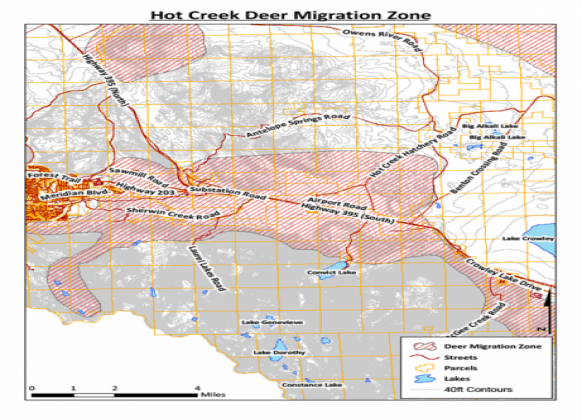
FIGURE 2: Hot Creek Buffer Zone
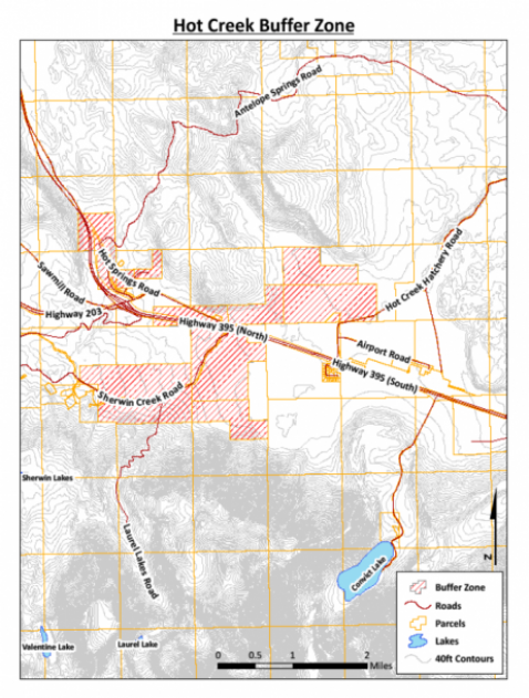
Policy 8.C.1. Geothermal development projects shall be phased so that the operational impacts of a permitted project can be assessed before a subsequent project is permitted within an area that may be affected by the permitted project.
Action 8.C.1.a. After a permit for geothermal development has been issued by Mono County, no subsequent application for a permit for geothermal development within an area that may be affected by the permitted project shall be accepted until hydrologic and biologic monitoring data relating to the permitted development has been collected for a period of not less than two years. If an area in which a new permit for geothermal development is sought has been previously developed and hydrologic and biologic monitoring data has been collected in the area for in excess of two years, it shall be not less than six months before the new application is accepted.
Action 8.C.1.b. Geothermal exploration and development operations shall be monitored, and the monitoring data shall be evaluated by the Mono County Community Development Department (MCCDD) and the Long Valley Hydrologic Advisory Committee (LVHAC), or other appropriate regional hydrologic committees, and CDFW. The purpose of the monitoring is to determine whether there are or may be adverse hydrologic or biologic impacts. The data and evaluations, to the extent they are not proprietary, shall become a part of the record of any proceeding to consider subsequent geothermal exploration or development permit applications within the Hot Creek Buffer Zone, the deer migration zones, or any other regions that may be affected by the existing projects.
Action 8.C.1.c. Prior to the issuance of any permit for either geothermal exploration or development within the Hot Creek Buffer Zone, the MCCDD shall prepare a written analysis of the cumulative hydrologic and biologic impacts of the proposed project and other development projects of any kind or nature that may individually or cumulatively affect springs, streams, fumaroles, or significant biologic resources within the zone. The analysis shall be a part of the record.
Action 8.C.1.d. Except for projects in the vicinity of Casa Diablo and associated monitoring or mitigation wells or other facilities, and notwithstanding the provisions of CEQA or the County guidelines, where there is credible scientific evidence contained in the foregoing cumulative impact analysis that shows that the project for which a permit is sought, taken together with other development and development projects, may substantially adversely affect springs, streams, or fumaroles within the Hot Creek Buffer Zone, the permit shall not be granted.
Objective 8.D.
The permit holder shall establish data collection for hydrologic and biologic mitigation and monitoring programs to serve as the basis for assuring protection of hydrologic and biologic resources and water quality and quantity. These programs shall be approved by the MCCDD, after consultation with the LVHAC or another appropriate regional hydrologic advisory committee, and the CDFW, prior to implementation.
Policy 8.D.1. Geothermal exploration and development projects shall be sited, carried out and maintained by the permit holder in a manner that best protects hydrologic resources and water quality and quantity.
Action 8.D.1.a. During the permit processing period, the applicant for a geothermal development permit shall submit draft hydrologic and biologic monitoring plans to the MCCDD. The plans and proposed mitigation measures, as modified and as accepted by the County or its officers, boards and commissions, shall be approved as part of the initial use permit conditions, if a permit is granted.
The operator under a geothermal development permit shall implement the hydrologic resource monitoring plan to monitor baseline conditions and detect changes in the existing hydrothermal reservoir pressures and shallow aquifer water levels, as well as the discharge (flow) rate and temperatures of selected thermal springs in the project area, if any exist.
Action 8.D.1.b. The monitoring plans shall include a formula to calculate the appropriate portion of costs to be repaid to the County by the permit holder in the event that the County expends monies to collect baseline data for the plans.
Action 8.D.1.c. Upon the basis of relevant scientific evidence and the recommendation of the LVHAC or another appropriate hydrologic review committee, the monitoring plans may be amended during operations upon prior written approval of the MCCDD or the Planning Commission.
Action 8.D.1.d. The hydrologic and biologic resource monitoring plans shall include:
- A schedule for periodically collecting and submitting data to the MCCDD;
- A schedule for preparing a periodic monitoring report to the MCCDD; and
- Provisions for periodic review and assessment of the monitoring data by qualified consultants.
Action 8.D.1.e. The applicant for a geothermal development permit shall prepare a baseline data report to be included as part of the hydrologic and biologic resource monitoring plans that identifies all significant hydrologic and biologic baseline information available for the project area. Permit conditions shall require that the permit holder or operator continually collect and submit production data to the MCCDD. The frequency and manner of data collection must be approved by the MCCDD, after consultation with the LVHAC or another appropriate hydrologic advisory committee, and the California Department of Fish and Wildlife.
Action 8.D.1.f. If scientific evidence indicates that geothermal exploration or development is significantly threatening, or causing, pressure or temperature changes to springs, streams or fumaroles within the areas of the Hot Creek Gorge or Hot Creek Hatchery that are beyond the natural variations determined through baseline data collection, the permit holder shall implement such mitigation measures as are required by the MCCDD, including, but not limited to, the following:
- Drilling and monitoring new observation wells, or otherwise amending the hydrologic resource monitoring plan;
- Reorienting existing exploration, production or injection operations, or any of them, to increase or decrease hydrologic reservoir temperatures or pressures at the appropriate locations;
- Injecting hot geothermal fluid from the production area directly into injection wells at the appropriate locations to compensate for pressure or temperature changes in the direction of Hot Creek Gorge springs and Hot Creek Hatchery springs, if either group of springs has been shown to be adversely affected by the permit holder's operations;
- Drilling new injection wells in the vicinity of the project area and injecting hot geothermal fluid from the production area to compensate for temperature and pressure decreases in the direction of Hot Creek Gorge springs and Hot Creek Hatchery springs, if either group of springs has been shown to be adversely affected by project operations; and
- Curtailing or entirely discontinuing geothermal operations.
Action 8.D.1.g. In order to minimize hydrothermal reservoir pressure declines, and provided the conditions do not conflict with regulations of the California Division of Oil and Gas, development permit conditions shall require the reinjection of substantially all extracted geothermal fluids. Incidental uses of the produced geothermal fluids (i.e., well drilling, well testing, emergency fire water makeup) are exempted from this injection requirement.
Action 8.D.1.h. The permit holder shall prepare and submit to the MCCDD, prior to commencement of construction, a detailed blowout contingency plan, which includes a description of blowout prevention equipment required during drilling. Sufficient cold water shall be stored by the permit holder at each well site to quench the well should a blowout occur during drilling.
Water used for this purpose shall not be extracted from surface water sources in a manner that would harm aquatic vertebrate species dependent upon the surface water source. The plan shall provide for regular maintenance and testing of equipment. It shall be approved by the MCCDD prior to operations as condition of the permit.
Action 8.D.1.i. If biologic monitoring indicates that permitted geothermal exploration, development and operations, or any of them, have significant adverse effects, then the County shall take such action as is necessary to reduce the effects to less-than-significant levels, including curtailing or entirely discontinuing geothermal operations.
Action 8.D.1.j. Binary working fluids shall be cooled without the use of additional hydrologic resources and without creating additional environmental impacts.
Action 8.D.1.k. The consumptive use of surface water and groundwater, consistent with the reasonable needs (as determined by the MCCDD) of project operations and personnel, shall not decrease the natural flow of surface waters or the perennial yield of groundwater.
Action 8.D.1.l. Appropriate measures shall be taken to confine fluid spills. The capacity of the containment facilities shall be equal to at least twice the volume of the entire fluid contents of the facility, including pipeline capacity and the amount that would flow until automatic shutdown devices would stop the flow.
Action 8.D.1.m. No geothermal development located within the Hot Creek Buffer Zone shall occur within 500 feet on either side of a surface watercourse (as indicated by a solid or broken blue line on US Geological Survey 7.5- or 15-minute series topographic maps).
Action 8.D.1.n. Permit conditions for both geothermal exploration and development shall assure that required reclamation is completed within one year after a project is completed. Reclamation plans shall contain provisions that assure the protection of springs, streams, and fumaroles from erosion, sediment transport, and similar adverse effects. Plan provisions shall also assure that project sites are restored as closely as reasonably possible to natural conditions, as determined by the MCCDD, in consultation with the Visual Review Committee.
Action 8.D.1.o. All geothermal permit applications, environmental documentation and proposed project conditions shall be referred to the appropriate hydrologic advisory committee and the California Department of Fish and Wildlife (CDFW) prior to final action on the permit applications.
Action 8.D.1.p. The County shall cooperate with the CDFW in promptly referring documentation on proposed geothermal projects to it.
Action 8.D.1.q. Permits for both geothermal exploration and development shall incorporate by reference and require compliance with all applicable rules and regulations of other governmental agencies meant to protect the environment, including the CDFW, the California Division of Oil and Gas, the Lahontan Regional Water Quality Control Board, and the Great Basin Unified Air Pollution Control Board.
Action 8.D.1.r. All geothermal pipelines potentially visible in scenic highway corridors or important visual areas shall be obscured from view by fences, natural terrain, vegetation, or constructed berms, or they shall be placed in stabilized or lined trenches.
Objective 8.E.
Permit conditions for geothermal exploration or development projects shall minimize impacts on deer migration within the deer migration zones identified in this Element.
Policy 8.E.1. Deer are an important natural, biological, and recreational resource. Geothermal exploration, development and operations shall be undertaken in a manner that minimizes or prevents adverse effects on deer population and migration within the deer migration zones.
Action 8.E.1.a. All policies and actions applicable to geothermal development generally that do not conflict with policies specifically applicable to deer migration zones shall be enforced by appropriate permit conditions.
Action 8.E.1.b. Development may be prevented in any part of a deer migration zone upon a finding that it will interfere with adopted regulations of the California Department of Fish and Wildlife and the goals of the CDFW deer herd management plans.
Action 8.E.1.c. The County shall cooperate with the CDFW in devising conditions meant to carry out this policy.
Objective 8.F.
Geothermal exploration and development projects shall be carried out with the fewest visual intrusions reasonably possible.
Policy 8.F.1. Permit conditions shall require compliance with all applicable policies and actions of the Conservation/Open Space Element.
Objective 8.G.
The permit holder shall establish procedures that ensure that neither geothermal exploration nor development will cause violations of state or federal ambient air quality standards or the rules and regulations of the Great Basin Unified Air Pollution Control District (GBUAPCD).
Policy 8.G.1. Permit conditions shall require compliance with all requirements of the regional air pollution control district, and with all other applicable provisions of the Conservation/Open Space Element.
Action 8.G.1.a. Air quality shall be monitored by a representative of the MCCDD, or the regional air pollution control district with jurisdiction. The costs of such monitoring shall be funded by the permit holder or project operator.
Objective 8.H.
Mono County shall establish procedures that assure that neither geothermal exploration nor development creates unacceptable noise.
Policy 8.H.1. Project conditions shall require compliance with all applicable provisions of the Noise Element and the County Noise Ordinance.
GOAL 9. Permit the productive and beneficial development of geothermal resources consistent with the objectives of Goal I and national and local interests.
Objective 9.A.
Provided that the environment is protected in the manner required by the policies and actions of Goal I of this section of the Conservation/Open Space Element, County policy shall ensure the orderly and sound economic development of geothermal resources under the appropriate circumstances.
Policy 9.A.1. Decisions on applications for geothermal development permits may take into account evidence of national needs for alternative energy development.
Policy 9.A.2. Decisions on applications for geothermal development permits should be relatively more favorable during times of scarcities of other energy sources.
Action 9.A.2.a. Applicants for permits for geothermal exploration and development may be required to submit information showing the benefits of geothermal energy during the proposed period of geothermal operations. Benefit may be established by showing a contract for the sale of geothermal power to a utility engaged in the business of providing electrical power to the general public.
Policy 9.A.3. Mono County's geothermal resources shall be managed in a manner that assures reasonable economic benefits to the citizens and businesses of the county.
Action 9.A.3.a. Applicants for permits for geothermal development shall be required to submit information showing the economic benefits or detriments of the proposed development during the proposed period of operation.
Action 9.A.3.b. Decisions on applications for development permits should not be made in the absence of information showing the economic benefit or detriment of such development to the citizens and businesses of Mono County, including impacts on natural resources.
Action 9.A.3.c. Geothermal development permits should not be granted in the absence of a reasonable showing of economic benefit to the community, unless findings are made that there are overriding state or national energy needs.
GOAL 10. Protect the natural resources of Mono County from the potentially damaging effects of water storage and diversions for hydroelectric power generation.
Objective 10.A.
Prevent conflict between the environment and hydroelectric power generation uses.
Policy 10.A.1. All hydroelectric power generation projects located on land under Mono County jurisdiction shall require a use permit. [3]
Objective 10.B.
Water diversions for hydroelectric power generation shall not occur on any stream that already has more than 20% of its length that is not contained in a wilderness area affected by water diversions or in a watershed that already has more than 25% of its average annual inflow diverted.
Policy 10.B.1. Mono County shall cooperate with the CDFW, State Water Resources Control Board, the BLM, the USFS, and the Federal Energy Regulatory Commission, in assessing impacts to streams from existing and proposed hydroelectric power generation, diversion for consumptive use, or other uses.
Action 10.B.1.a. Mono County shall develop, as part of its hydrologic database, information on water diversions (see the Water Resources Section of this Element).
Policy 10.B.2. The County shall consult with those federal and state decision-making bodies having the authority to grant permits for hydroelectric plants.
Objective 10.C.
Water diversions for hydroelectric power generation shall not be permitted to occur on any stream when credible scientific evidence indicates potential significant impacts to habitat for sensitive, listed or candidate threatened or endangered species; important spawning areas or other fishery values; key recreational resources; or viability for hydrologic research purposes, unless a statement of overriding considerations is made through the EIR process.
Policy 10.C.1. Mono County shall cooperate with the CDFW, US Fish and Wildlife Service, the BLM, and the USFS in assessing potentially sensitive surface water resources.
Action 10.C.1.a. Mono County shall develop, as part of its hydrologic database, information on water resources and areas that should be protected (see the Water Resources Section of this Element).
Policy 10.C.2. The County shall provide input to those federal and state decision-making bodies having the authority to grant permits for hydroelectric plants regarding criteria to be evaluated prior to issuing or denying permission to develop further the hydroelectric potential of already impacted streams and watersheds.
Objective 10.D.
Hydroelectric facilities shall be sited so that they are not easily visible from scenic highways or important visual areas.
Policy 10.D.1. Project conditions shall require compliance with all applicable provisions of the Conservation/Open Space Element.
GOAL 11. Encourage appropriately scaled renewable energy generation for use within the county.
Objective 11.A. Increase renewable energy generation that is consistent with the county’s visual and aesthetic qualities and values.
Policy 11.A.1. Support and incentivize residential and nonresidential distributed renewable energy generation.
Action 11.A.1.a. Pursue installation of solar photovoltaic systems, power purchase agreements, or solar collective programs to meet all or part of the electrical energy requirements of County-owned or -leased buildings.
Action 11.A.1.b. Continue offering and promoting incentives (e.g., streamlined permitting, prescriptive designs, fee waivers/reductions) to encourage installation of photovoltaic systems on new or existing buildings.
Action 11.A.1.c. Continue offering workshops and information for residents and businesses to provide resources and permitting assistance for those interested in adding renewable energy systems to their properties.
Policy 11.A.2. Encourage community-scale (<3 MW) renewable energy development on suitable lands, such as a biomass co-generation facility if sufficient supply becomes available.
Action 11.A.2.a. Support the development of appropriately sited community-scale renewable energy systems that meet critical evaluation criteria, such as environmental standards, sensitive species, financial feasibility, and transmission capacity.
Action 11.A.2.b. Work with utility providers, regulatory agencies, and local stakeholders to develop technical, environmental, and social feasibility.
Policy 11.A.3. Oppose commercial-scale (e.g., >3MW) solar and wind energy projects in Mono County on non-county public lands to protect visual, recreational, and wildlife habitat and biological resources, and the noise environment, and ensure projects on private lands protect these resources.
Action 11.A.3.a. Where pre-empted by state law or other jurisdictional authority, work with applicable agencies to avoid, minimize, and mitigate impacts to the environmental, visual, recreational, wildlife habitat and noise environment within the county.
Action 11.A.3.b. Ensure (or for non-county public lands advocate) for no adverse project impacts to the visual, recreational, and noise environment in Mono County.
Action 11.A.3.b. Ensure (or for non-county public lands advocate) for no adverse project impacts to biological resources and wildlife habitat in Mono County, including sage grouse habitat and wind energy development impacts to migratory birds.
GOAL 13. Regulate use of other energy resources for power generation to ensure that environmental impacts and impacts to public health and safety are minimal.
Objective 13.A.
During the course of evaluating any power generation project under the jurisdiction of Mono County, the California Energy Commission shall be consulted.
Policy 13.A.1. Mono County Community Development Department shall solicit assistance from the CEC for the purposes of reviewing proposed power generation facilities.
Objective 13.B.
Power generation facilities shall not adversely impact the visual resources, recreational resources, and noise environment in Mono County.
Policy 13.B.1. Project conditions shall require compliance with all applicable provisions of the Conservation/Open Space Element and the Noise Element.
Objective 13.C.
Emissions from the operation of power plants shall not adversely impact wildlife habitat, residents, or visitors and shall not constitute a hazard to public health and safety.
Policy 13.C.1. Project conditions shall require compliance with all applicable provisions of the Conservation/Open Space Element and the Safety Element.
GOAL 14. Minimize the visual, environmental, and public health and safety impacts of electrical transmission lines and fluid conveyance pipelines.
Objective 14.A.
Electrical transmission and distribution lines and fluid conveyance pipelines shall meet the utility needs of the public and be designed to minimize disruption of aesthetic quality. See also Chapter 11 of the Land Use Element.
Policy 14.A.1. New major steel-tower electrical transmission facilities shall be consolidated with existing steel-tower transmission facilities except where there are technical or overload constraints or where there are social, aesthetic, significant economic, or other overriding concerns.
Action 14.A.1.a. Require selection of rights of way to preserve the natural landscape and minimize conflict with present and planned uses of land on which they are to be located.
Action 14.A.1.b. Encourage the joint use of transmission and pipeline corridors to reduce the total number of corridors and service and access roads required.
Action 14.A.1.c. Require the coordination of siting efforts so that other comparable utility uses can share rights of way in a common corridor where feasible.
Action 14.A.1.d. The County shall adopt a proactive position in the future siting of transmission and pipeline corridors by working with utilities and project proponents to specify those locations where transmission corridors are acceptable.
Action 14.A.1.e. Cooperate with the USFS and BLM in planning the use of utility corridors.
Policy 14.A.2. At the expense of the project proponent, comprehensive and detailed planning studies, including review of all feasible alternatives, shall demonstrate a clear need for new transmission lines or fluid conveyance pipelines, prior to the siting of these facilities.
Policy 14.A.3. New transmission or distribution lines or fluid pipelines shall be buried when such burial does not create unacceptable environmental impacts or the potential to contaminate shallow groundwater resources.
Policy 14.A.4. Where burial is not possible, transmission facilities and fluid pipelines shall be located in relation to existing slopes such that topography and/or natural cover provide a background where possible.
Policy 14.A.5. Transmission line rights of way shall avoid crossing hills or other high points at the crests. To avoid placing a transmission tower at the crest of a ridge or hill, space towers below the crest or in a saddle to carry the line over the ridge or hill. The profiles of facilities should not be silhouetted against the sky.
Policy 14.A.6. Where transmission line rights of way cross major highways or rivers, the transmission line towers shall be carefully placed for minimum visibility.
Policy 14.A.7. Avoid diagonal alignments of transmission lines through agricultural fields to minimize their visibility.
Policy 14.A.8. Require location of access and construction roads so that natural features are preserved and erosion is minimized. Use existing roads to the extent possible.
Policy 14.A.9. Require that materials used to construct transmission towers harmonize with the natural surroundings. Self-protecting bare steel and other types of non-reflective surfaces are appropriate in many areas. Towers constructed of material other than steel, such as concrete, aluminum, or wood should be considered. Coloring of transmission line towers to blend with the landscape should be considered.
Policy 14.A.10. Above-ground transmission lines shall be non-specular wire construction.
Objective 15.B.
Transmission and distribution lines shall not adversely impact wildlife, fisheries, or public health and safety.
Policy 15.B.1. New transmission or distribution lines shall avoid open expanses of water, wetland, and sagebrush steppe, particularly those heavily used by birds. They shall also avoid nesting and rearing areas.
Policy 15.B.2. Avoid the placement of transmission or distribution lines through crucial wildlife habitats such as deer fawning and migration areas, and sage grouse lekking and brood-rearing habitat.
Policy 15.B.3. Design transmission lines to minimize hazards to raptors and other large birds, and require the installation of anti-perching devices when overhead placement in sensitive habitat is unavoidable.
Policy 15.B.4. Where burial is not possible, overhead transmission lines shall provide a maintenance and fire safety plan.
GOAL 15. Encourage the prudent use of energy and to allow substitution of alternative energy sources for conventional energy when such substitution would result in minimal environmental impacts.
Objective 15.A.
Promote the direct use of geothermal, biomass and other heat sources provided that such use does not conflict with recreational uses and does not create unmitigatible environmental impacts.
Policy 15.A.1. Support the use of direct alternative heat sources in Mammoth Lakes, Bridgeport, and other communities where such resources are available.
Action 15.A.1.a. Identify applications for the direct use of alternative heat sources, in addition to space heating, which could support environmentally compatible light industry (such as greenhouses, aquaculture, vegetable dehydration, etc.).
Action 15.A.1.b. Cooperate with other agencies and jurisdictions on the development and implementation of projects utilizing alternative heat sources.
Action 15.A.1.c. On potential thermal biomass projects, work with applicable entities to develop a tight management plan for on-site wood chip storage and handling to avoid spontaneous wood pile combustion, and determine distance to residential neighborhoods and uses to avoid complaints about odors.
Policy 15.A.2. Through participation in the LVHAC Hydrologic Monitoring Program, ensure the implementation of adequate geothermal reservoir monitoring for those direct use projects that have the potential to affect Hot Creek Hatchery springs or Hot Creek Gorge springs.
Goal 16. Improve energy efficiency in existing buildings.
Objective 16.A.
Improve the information and support available to residential and nonresidential property owners to reduce energy use.
Policy 16.A.1. Work with nonprofits and utility providers to provide property owners with technical assistance, energy efficiency programs, and financial incentives.
Action 16.A.1.a. Support and publicize compact fluorescent (CFL) or light-emitting diode (LED) giveaways, and incandescent bulb exchange programs.
Action 16.A.1.b. Work with utility providers to encourage home/commercial audits and energy efficiency retrofits.
Action 16.A.1.c. Support or host events that highlight and promote successful programs.
Action 16.A.1.d. Promote and reward energy efficiency efforts of local visitor-serving and recreational businesses.
Policy 16.A.2. Provide green building information and resources in a publicly available format, such as a dedicated page on the County website.
Action 16.A.2.a. Provide green building information and resources.
Action 16.A.2.b. Provide information about programs, rebates such as the California Solar Initiative, on-bill financing, or other financial incentives to help residents and businesses complete energy-saving measures such as audits and whole-house retrofits.
Action 16.A.2.c. Provide information on low-income assistance programs, such as weatherization.
Action 16.A.2.d. Provide information to local businesses about resource-efficient procurement opportunities.
Objective 16.B.
Increase the number of programs available and accessibility to capital to assist residential and nonresidential properties with implementation of resource-efficient practices.
Policy 16.B.1. Provide programs and information to reduce existing energy use.
Action 16.B.1.a. Offer a property assessed clean energy (PACE) financing program for residential and nonresidential energy efficiency.
Action 16.B.1.b. Work with the Great Basin Unified Air Pollution Control District to provide incentives to replace non-certified woodstoves with Environmental Protection Agency-certified wood or pellet stoves or propane units.
Policy 16.B.2. Encourage energy-efficient measures and practices through standard County programs, such as well and building permits.
Action 16.B.2.a. Promote installation of variable frequency drive water pumps to serve existing residential buildings.
Action 16.B.2.b. Encourage voluntary upgrades of residential and nonresidential HVAC systems.
Action 16.B.2.c. Encourage energy audits and voluntary retrofits for residential and nonresidential buildings at the time of sale or major renovation (>50% of building square footage, or addition of >500 square feet).
Policy 16.B.3. Provide incentives and information to support upgrades to rental properties, non-primary housing, and other types of housing.
Action 16.B.3.a. Promote opportunities to improve energy efficiency and install renewable energy systems in rental or secondary homes.
Action 16.B.3.b. Provide information on programs such as upgrades to mobile homes, blow-in insulation, and double-paned glazed low-e windows.
Objective 16.C. Reduce energy use in existing County facilities.
Policy 16.C.1. Continue progress toward net zero energy use in County facilities.
Action 16.C.1.a. Seek funding for and then develop a net zero energy feasibility study for County facilities that would include renewable energy generation, whole-building energy audits, construction costs and return on investment horizons, and potential time frames.
Action 16.C.1.b. Consider installing cool roof materials on existing and new County-owned buildings.
Action 16.C.1.c. Replace appliances and equipment in County-owned and leased buildings with energy-efficient models.
Action 16.C.1.d. Develop and implement a schedule—for example, through whole-building energy audits—to address no cost/low cost energy retrofit projects in County-owned and -leased buildings.
Action 16.C.1.e. Reduce energy demand in County-owned buildings by capturing “daylighting” opportunities.
Action 16.C.1.f. Collaborate with owners of leased buildings to audit and benchmark energy use, retrofit for efficiency, and develop a preferred leasing agreement that incorporates energy-efficient practices.
Policy 16.C.2. Continue to manage maintenance and ongoing programs that support energy reduction.
Action 16.C.2.a. Periodically audit and benchmark energy use in County-owned buildings to identify opportunities for energy efficiency and conservation.
Action 16.C.2.b. Ensure that HVAC and lighting systems in County-owned and -leased buildings are operating as designed and installed.
Action 16.C.2.c. Continue to use energy management software to monitor real-time energy use in County-owned and -leased buildings to identify energy usage patterns and abnormalities.
Action 16.C.2.d. Install motion sensors, photocells, and multi-level switches to control room lighting systems in County-owned and -leased buildings.
Action 16.C.2.e. Encourage utility providers to install smart meters on County-owned buildings.
Goal 17. Reduce energy use in new construction and major renovations.
Objective 17.A.
Increase green building practices in new construction and major renovations.
Policy 17.A.1. Support and promote residential and nonresidential green building construction.
Action 17.A.1.a. Offer incentives (e.g., streamlined permitting, prescriptive designs, fee waivers/reductions) for green building practices, such as verifiable green building practices that exceed state or local minimum standards, ground-source heat pumps, or photovoltaic solar installations.
Action 17.A.1.b. Work with utility providers to provide information to businesses about available rebates for new residential and commercial buildings that exceed Title 24 by at least 15%.
Action 17.A.1.c. Offer technical expertise and assistance for community members, builders, and businesses undertaking green building projects.
Action 17.A.1.d. Provide information on how contractors can attend energy efficiency training.
Policy 17.A.2. Continue to transition to green building practices in new County facilities.
Action 17.A.2.a. Consider certification by a third-party rater to ensure all new County facilities and renovations of existing facilities comply with green building standards.
Action 17.A.2.b. Target meeting net-zero energy requirements or exceeding minimum Title 24 requirements for new County buildings and renovation of existing facilities.
Goal 18. Collaborate with community partners, and empower the public to improve resource efficiency within the county.
Objective 18.A. Leverage resources regionally to build capacity for resource efficiency programs.
Policy 18.A.1. Work with local schools to support educational opportunities that promote resource efficiency.
Action 18.A.1.a. Collaborate with high schools to provide students with resource-based internship opportunities.
Action 18.A.1.b. Partner with local community colleges and grade schools to develop classes or workshops with a resource focus.
Policy 18.A.2. Collaborate with local, state, and regional agencies and organizations to identify resource conservation opportunities and share information.
Action 18.A.2.a. Integrate energy conservation discussions and opportunities into projects or efforts with other federal, state, and regional agencies.
Action 18.A.2.b. Utilize the Regional Planning Advisory Committees to create ongoing opportunities for community members to provide feedback on resource policies and programs.
Action 18.A.2.c. Promote the Mono County “Living Light Guide” that outlines steps residents and businesses can take to reduce energy and water use, recycle, and use alternative transportation.
Action 18.A.2.d. Include information in County mailings, websites, and other media about actions that individuals and businesses can take to improve resource efficiency.
Action 18.A.2.e. Participate in the CoolCalifornia Challenge which challenges local agencies to engage residents in taking action to reduce household energy use and vehicle miles traveled.
Policy 18.A.3. Support and participate in the outreach, education, and collaboration efforts of the Eastern Sierra Energy Initiative partnership.
Action 18.A.3.a. Distribute giveaway items, such as reusable bags and compact fluorescent (CFL) light bulbs, to encourage environmental responsibility.
Action 18.A.3.b. Develop public service announcements and/or talk shows related to resource efficiency.
Action 18.A.3.c. Use social media to inform the community about resource efficiency activities and opportunities.
Action 18.A.3.d. Host a leadership summit for community leaders, school groups, and businesses to gather and share resource conservation experiences, expertise, strategies, and ideas.
Action 18.A.3.e. Provide recognition programs for individuals, groups, and businesses that adopt resource efficiency practices.
Goal 19. Reduce generation of waste within the county. (See also the County’s Integrated Waste Management Plan.)
Objective 19.A. Reduce waste deposited in the County’s landfills.
Policy 19.A.1. Increase composting and recycling programs, and reduce waste generation, throughout the county.
Action 19.A.1.a. Identify and encourage reducing, reusing, and recycling opportunities for construction and demolition waste.
Action 19.A.1.b. Establish a program to use the maximum amount of organic waste possible generated within the county to produce compost for use in parks and landscaping.
Action 19.A.1.c. Increase opportunities for e-waste and hazardous materials collection and recycling.
Action 19.A.1.d. Evaluate current recycling infrastructure relative to future needs and anticipated waste generation. Provide incentives for new recycling infrastructure facilities in the county.
Action 19.A.1.e. Encourage the installation of recycling receptacles and containers at multi-family housing developments.
Action 19.A.1.f. Explore measures to reduce waste from commercial operations, such as banning single-use bags and polystyrene containers.
Policy 19.A.2. Promote a standard of reduce, reuse, and recycle within County government operations.
Action 19.A.2.a. Provide County staff with information on recycling items such as ink cartridges, toner, batteries, and light bulbs.
Action 19.A.2.b. Encourage paper use reduction through activities such as:
- Promoting a “think before you print” campaign.
- Reducing margins and logos on County templates, letterhead, and memos.
- Setting printer default options to print double-sided pages.
- Using computer software that removes blank pages and images from documents.
- Using “e-copy” machines that allow users to scan and distribute documents via e-mail.
- Uploading bid documents using online resources.
- Requiring fewer or smaller-sized copies of project plans or submittals, and allowing digital submittals.
- Using electronic devices for agendas and notes at public meetings.
Action 19.A.2.c. Review and implement the adopted procurement policy to establish purchasing standards for climate-friendly products.
Policy 19.A.3. Partner with other agencies, such as the Town of Mammoth Lakes, on green procurement, waste reduction, and recycling activities.
Objective 19.B. Reduce greenhouse gas emissions from County solid waste operations.
Policy 19.B.1 Reduce or offset methane generation from County landfills.
Action 19.B.1.a. Investigate new technologies available to capture methane at County landfills.
Action 19.B.1.b. Identify opportunities to install renewable energy systems at County landfills.
[3]Only those retrofit projects that entail major revisions to or replacement of the primary components of the system (i.e., penstock, generator, diversion structure, etc.) shall require a use permit.
GOAL 20. Protect and enhance the visual resources and landscapes of Mono County.
Objective 20.A.
Maintain and enhance visual resources in the county.
Policy 20.A.1. In order to protect and enhance important scenic resources and scenic highway corridors as identified in the MEA, designate such areas throughout the county for Open Space, Agriculture, Resource Management, or similar low intensity uses.
Action 20.A.1.a. Identify important scenic resources, including scenic highway corridors, in the MEA.
Policy 20.A.2. Coordinate county visual resource policies with federal and state visual policies and objectives.
Action 20.A.2.a. Work with federal, state, local, and other appropriate organizations to review and coordinate the protection and enhancement of the county's scenic resources.
Policy 20.A.3. Preserve the visual identity of areas outside communities.
Action 20.A.3.a. Concentrate future development in or adjacent to existing communities.
Action 20.A.3.b. Retain the rural character of areas outside existing communities by restricting development to low-intensity uses; high-intensity uses outside communities should be permitted only through the Specific Plan process.
Action 20.A.3.c. Avoid the inclusion of scenic areas within spheres of influence for urban service providers.
Action 20.A.3.d. Consider providing opportunities for development in scenic areas in exchange for permanent open-space preservation.
Policy 20.A.4. Protect significant scenic areas by maintaining land in those areas in public ownership.
Action 20.A.4.a. Encourage the use of federal and state designations that recognize significant scenic areas.
Action 20.A.4.b. Encourage the transfer of ownership of visually significant private land to public land management agencies or land conservation organizations for the purpose of preserving scenic resources.
Action 20.A.4.c. Encourage private landowners with visually significant property to grant or sell a conservation easement to a land conservation organization to protect the land as open space, including continued agricultural uses.
Action 20.A.4.d. Continue to use land use regulations and subdivision regulations to preserve open space for scenic purposes.
Action 20.A.4.e. Conserve scenic highway corridors by maintaining and expanding large-lot land use designations in areas within view of scenic highways.
Policy 20.A.5. Restore visually degraded areas when possible.
Action 20.A.5.a. Promote reclamation of existing quarry sites to natural conditions following exhaustion of the mineral resource or abandonment of operations.
Action 20.A.5.b. Work with existing uses to mitigate the adverse visual impacts of those uses; e.g., by painting, landscaping, or otherwise screening the use.
Action 20.A.5.c. Encourage private restoration of disturbed sites.
Action 20.A.5.d. Consider visual impacts during the Grading Permit Process.
Action 20.A.5.e. Require the restoration of disturbed sites following construction, but prior to issuance of a Certificate of Occupancy.
Policy 20.A.6. Restore abandoned roadway sections and/or improvements along scenic highways.
Action 20.A.6.a. Require the governmental entity responsible for the roadway abandonment to restore the road bed and adjacent area to a condition comparable to surrounding lands.
Objective 20.B.
Maintain a countywide system of state and County-designated scenic highways[4]. (See RTP for designated roads.)
Policy 20.B.1. Maintain existing State-designated scenic highways.
Action 20.B.1.a. Enforce required regulations for protection of roadways designated as state scenic highways.
Action 20.B.1.b. Work with appropriate agencies to protect visual resources within existing designated scenic highway corridors[5].
Action 20.B.1.c. Work with Caltrans to ensure that state scenic highways are properly signed.
Policy 20.B.2. Seek state scenic highways designation for additional mileage in Mono County.
Action 20.B.2.a. Apply to Caltrans for designation of additional Mono County roadways as state scenic highways.
Policy 20.B.3. Maintain existing County-adopted scenic highways.
Action 20.B.3.a. Study the feasibility and desirability of a County signing program for County-adopted scenic highways.
Policy 20.B.4. Designate additional mileage for the County-adopted scenic highway system.
Action 20.B.4.a. Identify appropriate new road segments for designation.
Policy 20.B.5. Seek state designation of County-adopted scenic highways as official County scenic highways.
Action 20.B.5.a. Apply to Caltrans for designation of County-adopted scenic highways as official County scenic highways.
Policy 20.B.6. Support designation of appropriate highways as National Scenic Byways.
Objective 20.C.
Ensure that development is visually compatible with the surrounding community, adjacent cultural resources, and/or natural environment.
Policy 20.C.1. Future development projects shall avoid potential significant visual impacts or mitigate impacts to a level of non-significance, unless a statement of overriding considerations is made through the EIR process.
Action 20.C.1.a. Future development projects with the potential to have a substantial, demonstrable negative aesthetic effect shall provide a visual impact analysis prior to project approval. Examples of a substantial, demonstrable negative aesthetic effect include:
- Reflective materials;
- Excessive height and/or bulk;
- Standardized designs that are utilized to promote specific commercial activities and that are not in harmony with the community atmosphere;
- Architectural designs and features that are incongruous to the community or area and/or that significantly detract from the natural attractiveness of the community or its surroundings;
- Dust or steam plumes; and
- Excessive night lighting.
The analysis shall:
- be funded by the applicant;
- be prepared by a qualified person under the direction of Mono County;
- assess the visual environment in the general project vicinity;
- describe the impacts of the proposed development upon views and scenic qualities within the project site and on surrounding areas; and
- recommend project alternatives or measures to avoid or mitigate visual impacts.
Mitigation measures shall be included in the project plans and specifications and shall be made a condition of approval for the project.
Policy 20.C.2. Future development shall be sited and designed to be in scale and compatible with the surrounding community and/or natural environment,
Action 20.C.2.a. Utilize the General Plan design guidelines (see appendices) for residential, commercial, and industrial development projects. At a minimum, the following development standards shall apply:
- Projects should not dominate the natural environment, and should complement existing community character; the scale, design, and siting of a project should be appropriate for the setting;
- Building mass should be varied and should be appropriate for the surrounding community or area. Facades in commercial districts should be varied;
- Project siting and structural design should be sensitive to the climate, topography, and lighting of the surrounding environment;
- The design, color, and building materials for structures, fences, and signs shall be compatible with the natural environment and/or surrounding community;
- Visually offensive land uses shall be adequately screened through the use of landscaping, fencing, contour grading, or other appropriate measures;
- The visual impacts of parking areas shall be minimized through the use of landscaping, covered parking, siting that screens the parking from view, or other appropriate measures;
- Signs shall comply with the county's Sign Ordinance;
- Standardized commercial structures, design, and materials shall not be allowed (e.g., a chain franchise shall be designed with materials and finishes that harmonize with the surrounding area);
- Industrial areas shall be as compact as possible;
- Exterior lighting shall be shielded and indirect, shall be minimized to that necessary for security and safety, and shall comply with the Dark Sky Regulations where applicable;
- All new utilities shall be installed underground, in conformity with applicable provisions of the Mono County General Plan (see Chapter 11 of the Land Use Element);
- Existing roads shall be utilized whenever possible. Construction of new roads should be avoided except where essential for health and safety;
- Earthwork, grading, and vegetative removals shall be minimized; and
- All site disturbances shall be revegetated with a mix of species native to the site and shall control for the establishment of invasive, non-native plants including annual grasses. A landscaping plan shall be submitted and approved for all projects.
Action 20.C.2.b. County staff may require project modifications as necessary to implement Policy 2 and Action 2.1 above.
Action 20.C.2.c. Encourage the establishment of Design Review Districts within community areas, in order to provide design guidelines that are more specific to each community.
Action 20.C.2.d. Apply the Scenic Combining District designation in order to minimize the impacts of development in scenic areas outside communities, including in scenic highway corridors.
Action 20.C.2.e. Require the establishment of building envelopes during the subdivision process, where appropriate, to mitigate visual impacts.
Action 20.C.2.f. Work with federal and state agencies on development projects on their lands to ensure that potential adverse visual impacts are fully mitigated.
Action 20.C.2.g. Existing visually offensive land uses located within scenic highway corridors should be adequately landscaped or otherwise screened.
Action 20.C.2.h. Require any expansion of existing visually offensive land uses within scenic highway corridors to be adequately landscaped or otherwise screened.
Action 20.C.2.i. Require visually compatible drainage improvements in scenic highway corridors, and comply with the requirements of applicable agencies such as the CDFW, Lahontan Regional Water Quality Control Board, and Army Corps of Engineers. When feasible, do not place streams in underground drainage structures.
Action 20.D.2.j. Reconsider development impact fees and other funding to improve new drainage systems in communities, and consider a requirement for development to fully mitigate drainage impacts.
Policy 20.C.3. Proposed transmission and distribution lines shall be designed and sited to minimize impacts to natural and visual resources.
Action 20.C.3.a. Install utilities underground in conformity with Chapter 11 of the Land Use Element and the Mono County Code.
Action 20.C.3.b. Require that utilities for all new subdivisions be installed underground, unless specific hardships can be demonstrated in conformity with the Mono County Code.
Action 20.C.3.c. Pursue the establishment of underground utility districts within scenic highway corridors as a mechanism to place existing overhead lines underground.
Action 20.C.3.d. Apply to SCE for financial support to convert eligible overhead lines to underground utilities.
Action 20.C.3.e. Enforce the policies in the Energy section of the Conservation/Open Space Element pertaining to the siting and design of transmission lines and fluid conveyance pipelines.
Action 20.C.3.f. Avoid siting cellular towers in Bi-State sage grouse habitat to the extent possible; if no alternatives exist, site towers in lowest quality habitat possible.
Policy 20.C.4. Promote revegetation and reforestation programs along County roads, including designated scenic highways.
Action 20.C.4.a. Seek funding and work with appropriate agencies to develop and implement revegetation and reforestation programs along County roads, including scenic highways.
Action 20.C.4.b. Revegetation plans should include measures to ensure the control of invasive, non-native plants including annual grasses.
Action 20.C.4.c. Revegetation plans should utilize plantings from local native stock, including adjacent riparian and wetland plants, and locally collected seed when feasible.
Action 20.C.4.d. Seek ways to form partnerships that will facilitate mitigative control or eradication of invasive non-native plants in and around town areas. Identify and explore methods of forming collaborations, funding, and facilitating such programs.
Policy 20.C.5. Minimize the visual impact of signs within designated scenic highway corridors.
Action 20.C.5.a. Prohibit billboards and off-premises advertising signs within scenic highway corridors.
Action 20.C.5.b. Amend the Sign Ordinance to regulate the number, type, size, height, design, materials, color and texture of on-premise attached signs within scenic highway corridors.
Action 20.C.5.c. Require a use permit for all on-premise freestanding signs in scenic highways corridor.
Action 20.C.5.d. Amend the Sign Ordinance to clarify the amortization procedures for non-conforming signs.
Policy 20.C.6. Establish and implement roadway improvement standards for designated scenic highways.
Action 20.C.6.a. Make every effort to work within existing rights of way rather than constructing new roads through scenic areas.
Action 20.C.6.b. Ensure that aesthetics is a major consideration in the design of any new roads through scenic areas.
Action 20.C.6.c. In order to minimize the disruption that can result from the construction of a new road through a scenic area, clear cutting and hillside cuts should be avoided whenever possible.
Objective 20.D.
Heighten awareness of Mono County's unique visual environment.
Policy 20.D.1. Tourist facilities should be located to take advantage of scenic views. (Also see RTP policies.)
Action 20.D.1.a. Work with federal, state, and local agencies to construct roadside turnouts with interpretive information for scenic vistas.
Action 20.D.1.b. Work with federal, state, and local agencies to develop a scenic vista signing program that marks scenic viewpoints from roadways.
Policy 20.D.2. Provide roadside improvements for designated county and state scenic highways. (Also see RTP policies.)
Action 20.D.2.a. Work with appropriate agencies and individuals to develop scenic view areas and roadside stops whenever feasible within scenic highway corridors.
Action 20.D.2.b. Install bicycle lanes, equestrian trails, and foot trails where appropriate along scenic highways.
Action 20.D.2.c. Protect and enhance all historical structures and points of interest and the visual state of their surroundings whenever possible within and adjacent to scenic highway corridors.
Action 20.D.2.d. Encourage the USFS, the BLM, and Caltrans to provide funding for roadside improvements.
Policy 20.D.3. Continue to conduct an anti-litter campaign along County roadways.
Action 20.D.3.a. Continue to place garbage cans at pullouts where appropriate along roadways.
Action 20.D.3.b. Encourage participation in Caltrans' Adopt-A-Highway Program.
Action 20.D.3.c. Continue to enforce litter abatement laws, including fines.
[4]Scenic Highway - Any freeway, highway, road, street, boulevard, or other public right of way that traverses an area of unusual scenic quality and has been designated as a Scenic Highway by the county Board of Supervisors and/or the State of California.
[5]Scenic Highway Corridor - The area of land generally adjacent to (within 1,000 feet) and visible from the highway, which requires protective measures to ensure perpetuation of its scenic qualities. Scenic Highway Routes consist of both the public right of way and the scenic corridor.
GOAL 21. Provide opportunities for outdoor recreation to meet the needs of residents and visitors in a manner that conserves natural and cultural resources.
Objective 21.A.
Provide sufficient recreational facilities and opportunities for residents.
Policy 21.A.1. Each community should have a community center, when supported by local residents, and a full range of community recreation facilities.
Action 21.A.1.a. Maintain existing community recreation facilities first, and then seek to improve and expand.
Action 21.A.1.b. Work with communities and other groups as feasible to operate and maintain parks.
Policy 21.A.2. Plan, design, and construct parks and recreation facilities to coincide with projected growth.
Action 21.A.2.a. Provide new park facilities and outdoor recreation amenities to accommodate growing populations.
Action 21.A.2.b. County park facilities should be accessible to all segments of the population, including persons with disabilities, young, and elderly, where feasible.
Action 21.A.2.c. Encourage the formation of a self-supporting park system by employing user fees (where appropriate), concessionaire revenues, soliciting grants and private contributions, requesting volunteer help, and by other means that further cost-effective park operations.
Action 21.A.2.d. Continue working with the Town of Mammoth Lakes to provide joint use park and recreation facilities. Ensure equitable support by the Town for the provision of these services.
Action 21.A.2.e. Identify, designate and acquire sites for parks and other recreation facilities of sufficient size and location for future development.
Action 21.A.2.f. Prioritize site acquisitions.
Action 21.A.2.g. Where feasible, acquire public lands for parks and ball fields through land exchanges and special use permits.
Action 21.A.2.h. Develop and adopt a funding plan to acquire sites and/or conservation easements and to fund needed recreation facilities.
Action 21.A.2.i. Continue pursuing state and federal grant moneys and moneys available from nonprofit corporations for the acquisition, construction, and maintenance of parks and other recreation facilities.
Action 21.A.2.j. Promote the establishment and enactment of development impact fees requiring new developments to dedicate land, contribute to a fund, or a combination of both, for parks and recreational purposes.
Action 21.A.2.k. Through the Specific Plan process, provide incentives for developers to dedicate areas for parks and to plan for the development of parks.
Policy 21.A.3. The location and design of recreational facilities should reflect environmental constraints and site characteristics.
Action 21.A.3.a. All applications for recreational projects shall be required to address the potential adverse impacts of the development. Applications shall include measures to mitigate potential impacts.
Action 21.A.3.b. Locate and design community parks to minimize their effects on surrounding land uses.
Action 21.A.3.c. Provide adequate buffer zones around community parks.
Action 21.A.3.d. Minimize the use of outdoor lights.
Policy 21.A.4. Through the Specific Plan process, provide incentives for developers to provide public indoor recreation facilities, such as swimming facilities, basketball courts, etc.
Objective 21.B.
Provide sufficient recreational facilities and opportunities outside community areas for residents and visitors.
Policy 21.B.1. Work with appropriate agencies and organizations to provide a full range of recreation opportunities to meet varied interests.
Action 21.B.1.a. Provision of County parks should occur in coordination with federal, state, and local agencies, and other recreation providers to avoid duplication of services and to ensure a full range of recreation opportunities.
Action 21.B.1.b. Participate in the development of recreation plans and policies with other agencies and organizations.
Policy 21.B.2. Recreational development outside community areas should be responsive to environmental limitations and market demand.
Action 21.B.2.a. Applications for such recreational projects shall be required to address the potential adverse impacts of the development. Applications shall include measures to mitigate potential impacts.
Action 21.B.2.b. Development proposals for major recreation facilities outside community areas may be required to submit a market-demand analysis.
Policy 21.B.3. Reduce incompatibility between recreation uses and neighboring uses.
Action 21.B.3.a. Review locations of proposed recreational uses to ensure that the location is compatible with neighboring uses.
Policy 21.B.4. Protect natural resources from overuse due to recreational uses.
Action 21.B.4.a. Work with appropriate agencies to develop capacity goals for recreation facilities and to monitor visitor usage at recreation facilities.
Policy 21.B.5. Preserve rivers that provide recreational opportunities.
Action 21.B.5.a. Pursue Wild and Scenic River designation for appropriate County waterways.
Objective 21.C.
Provide convenient and safe access to recreation sites. Also see the Regional Transportation Plan and Mono County Trails Plan (in the RTP Appendices).
Policy 21.C.1. Local trails should connect to regional and interstate trails, where feasible.
Action 21.C.1.a. Inventory and map all trails in Mono County.
Action 21.C.1.b. Meet with federal and state agencies to identify priority trail links.
Action 21.C.1.c. Seek partnerships and funding to develop and construct trail improvements, including trails on public lands.
Action 21.C.1.d. Investigate the feasibility of creating trails in utility corridors.
Action 21.C.1.e. Meet with other agencies to compare capital improvement programs and eliminate overlap of projects.
Policy 21.C.2. Encourage connections between trails and other transportation systems; e.g., public transit systems.
Policy 21.C.3. When appropriate, major recreation destinations, such as lakes, ski areas or cultural resource areas, should have public transportation systems that serve them as an alternative to the private automobile.
Action 21.C.3.a. Development applications for major recreation projects shall address traffic impacts. The analysis shall include mitigation measures.
Policy 21.C.4. All communities should have trails and public transit services that link the community to adjacent recreation opportunities, where feasible.
Policy 21.C.5. Provide for public access from public roadways to navigable waterways through the subdivision process in a manner consistent with the Subdivision Map Act and other applicable laws.
Objective 21.D.
Encourage and promote year-round use of seasonal recreation areas and facilities.
Policy 21.D.1. Seasonal facilities should provide opportunities for alternative uses in the off-season.
Action 21.D.1.a. Where appropriate, encourage multi-season programming for recreation facilities, such as June Mountain Ski Area, and amenities, such as the use of alpine ski trails for summer mountain bike use.
Action 21.D.1.b. Increase public awareness of seasonal recreation opportunities through promotional programs.
GOAL 22. Identify, preserve, restore, and interpret cultural resources[6] in Mono County.
Objective 22.A.
Provide a comprehensive approach to cultural resources management.
Policy 22.A.1. Establish a Cultural Resources Management Program.
Action 22.A.1.a. Develop a Cultural Resources Management Ordinance that includes criteria, standards, and guidelines for identifying, preserving, and protecting the county's cultural resources.
Action 22.A.1.b. Establish a Cultural Resources Management Commission to administer the Cultural Resources Management Program, to identify cultural resources, to apply for cultural resources grants, to act as a liaison with federal, state, and local agencies involved in cultural resources management, and to review development proposals affecting significant cultural resources.
Action 22.A.1.c. Consider membership in the California Preservation Foundation and the National Trust for Historic Preservation to keep apprised of pending legislation, workshops, publications, available funding, educational opportunities and incentive for implementing historic preservation programs.
Policy 22.A.2. Establish a Local Mono County Historic Register of historical or architecturally significant sites, places, historic districts or landmarks.
Action 22.A.2.a. Develop criteria in cooperation with other federal, state, and local agencies to determine which cultural resources are significant.
Action 22.A.2.b. Develop procedures in the Cultural Resources Management Ordinance for the preservation and protection of significant resources, including guidelines for the use of mitigation measures to address the impacts of development on cultural resources.
Action 22.A.2.c. Prioritize sites to be nominated to the National Register of Historic Places and/or as California Historic Landmarks or Points of Historical Interest, as well as routes to be nominated for National Trails designation or the California Trails System.
Action 22.A.2.d. Make recommendations to the Board of Supervisors concerning the local designation of cultural landmarks and districts.
Action 22.A.2.c. Adopt an ordinance establishing that buildings on the Mono County Historic Register shall be deemed “qualifying structures,” eligible to use the State Historical Building Code pursuant to Section 18955 of the Health and Safety Code.
Eligibility criteria for listing shall be as follows:
A property is eligible for consideration to be listed on the Mono County Register if it meets one of the following criteria:
- Buildings and structures on the National Register of Historic Places, and/or the California Register of Historic Places shall be automatically eligible to be included on the Mono County Historic Register;
- It exemplifies or reflects significant elements of Mono County’s cultural, social, religious, economic, political, engineering or architectural history;
- It is identified with historic persons or with important events in local, state or national history;
- It embodies distinguished architectural characteristics valuable for a study of a period style or method of construction or is a valuable example of the use of indigenous materials or workmanship;
- It is representative of a notable work of a master builder or architect.
Policy 22.A.3. Obtain funding to implement the Cultural Resource Management Program.
Action 22.A.3.a. Apply to the State Office of Historic Preservation for Certified Local Ordinance Status and Certified Local Government status.
Action 22.A.3.b. Consult with federal, state, and nonprofit groups concerning the availability of grants and funding for cultural resources preservation and management. Seek funding from available sources.
Action 22.A.3.c. Consider using historic preservation to bolster applications to fund transportation projects including bicycle/pedestrian pathways, grants, etc.
Policy 22.A.4. Encourage private preservation and conservation efforts.
Action 22.A.4.a. Contact owners of privately owned cultural resource sites to discuss long-term plans for the sites and the possibility of obtaining grants or loans for restoration.
Action 22.A.4.b. Encourage productive and economically attractive uses of historic properties and structures.
Action 22.A.4.c. Provide technical assistance to private owners of cultural resource properties wishing to preserve, protect, or restore their properties.
Action 22.A.4.d. Consult with Mono County Economic Development Department to maximize potential advantages of historic preservation of cultural resource properties.
Policy 22.A.5. Encourage a coordinated and cooperative approach to cultural resources management.
Action 22.A.5.a. Work with appropriate federal, state, and local agencies in the development and implementation of the Cultural Resource Management Program.
Action 22.A.5.b. Implement procedures for consulting with local Native American groups and with the California Native American Heritage Commission to ensure that federal and state requirements concerning the preservation and protection of Native American remains are met. Integrate consultation procedures with CEQA requirements.
Action 22.A.5.c. Adopt provisions in the Cultural Resource Management Ordinance to ensure that traditional Native American religious and cultural practices are protected.
Action 22.A.5.d. Support efforts to gain tribal recognition for the Mono Lake Indian Community. (See Mono Basin Plan: Page 29: Goal 3; Objective A; Policy 5; Action 5.1)
Objective 22.B.
Identify and inventory cultural resources in Mono County.
Policy 22.B.1. Work with private land owners to conduct a comprehensive inventory of cultural resources on private lands.
Action 22.B.1.a. Work with federal, state, and local agencies to analyze current data on cultural resources in the county, to develop a work program for a cultural resources inventory on private lands in the county, and to coordinate with inventory data on public lands.
Action 22.B.1.b. Investigate cooperative approaches to conducting a cultural resources inventory.
Action 22.B.1.c. Seek public involvement in the inventory process.
Action 22.B.1.d. Seek funding and establish procedures for an ongoing update of the inventory.
Objective 22.C.
Preserve, protect, and restore (where appropriate) the cultural resources of Mono County.
Policy 22.C.1. Future development projects shall avoid potential significant impacts to cultural resources or mitigate impacts to a level of non-significance, unless a statement of overriding considerations is made through the EIR process.
Action 22.C.1.a. Future development projects with the potential to significantly impact cultural resources shall provide an analysis of the potential impact(s) prior to project approval. Examples of potential significant impacts include:
- disrupting or adversely affecting a prehistoric or historic archaeological site or a property of historic or cultural significance to a community or ethnic or social group, or a paleontological site except as a part of a scientific study; and/or
- conflicting with established recreational, educational, religious or scientific uses of the area.
The analysis shall:
- be funded by the applicant;
- be prepared by a qualified person under the direction of Mono County;
- assess the cultural resources in the general project vicinity;
- describe the impacts of the proposed development upon cultural resources within the project site and on surrounding areas; and
- recommend project alternatives or measures to avoid or mitigate impacts to cultural resources.
Mitigation measures shall be included in the project plans and specifications and shall be made a condition of approval for the project.
Action 22.C.1.b. Develop criteria in cooperation with other federal, state, and local agencies, to determine which cultural resources are significant.
Action 22.C.1.c. Develop procedures in the Cultural Resource Management Ordinance for the preservation and protection of significant resources, including guidelines for the use of mitigation measures to address the impacts of development on cultural resources.
Action 22.C.1.d. Prioritize sites to be nominated to the National Register of Historic Places and/or as California Historic Landmarks or Points of Historical Interest, as well as routes to be nominated for National Trails designation or the California Trails System.
Action 22.C.1.e. Make recommendations to the Board of Supervisors concerning the local designation of cultural landmarks and districts.
Policy 22.C.2. Explore all available measures, including the purchase of easements, dedication to the County, tax relief, the purchase of development rights, the formation of a local land trust, and the consideration of reasonable project alternatives in order to avoid development on or adjacent to culturally sensitive sites.
Policy 22.C.3. Establish buffer zones around significant cultural resource sites to protect the integrity of the resource, as well as the integrity of the setting.
Action 22.C.3.a. Work with the State Department of Parks and Recreation to address compatible land uses adjacent to State Historic Park properties.
Action 22.C.3.b. Encourage the State to purchase properties adjacent to State Historic Park properties in order to prevent impacts from future adjoining incompatible uses.
Action 22.C.3.c. Support the acquisition of areas with cultural resource values by federal or state land management agencies or land conservation organizations.
Action 22.C.3.d. Protect existing open space and/or designate or acquire open space around identified cultural properties to provide buffer space and to protect historic settings.
Action 22.C.3.e. Encourage other federal, state, and local agencies, as well as private individuals and organizations, to provide buffer zones around cultural properties.
Policy 22.C.4. Restore and maintain significant cultural resource sites.
Action 22.C.4.a. Adopt policies and standards in the Cultural Resource Management Ordinance for the maintenance and restoration of significant cultural resources.
Action 22.C.4.b. Establish a fund for the purchase, maintenance, and restoration of significant cultural resources.
Action 22.C.4.c. Study the potential of amending the General Plan to establish a cultural resource overlay designation and/or local cultural resource or historic districts. Parcel owner consent shall be obtained prior to rezoning property for historic preservation or listing on County register.
Policy 22.C.5. Implement incentives to encourage private preservation and conservation efforts.
Action 22.C.5.a. Develop tax incentives for the preservation or faithful restoration of properties with identified cultural resource value. Consider implementation in Mono County of the Mills Act; 1986 Tax Reform Act, Marks Historical Rehabilitation Act, among other tax incentives.
Action 22.C.5.b. Adopt the State Historic Building Code, in lieu of the Uniform Building Code, for significant historic structures.
Action 22.C.5.c. Establish requirements in the Cultural Resources Management Ordinance for compatible alterations and additions to historic structures.
Action 22.C.5.d. Allow minor variations from land use designation requirements (e.g., setbacks, parking standards) to maintain the historic quality of cultural properties.
Action 22.C.5.e. Consider adopting fee waiver provisions to include waiving development permit fees for site review, site development, and conditional use permits for work done on Mono County Historic Register and National Register structures that is consistent with the Secretary of the Interior’s Standards for Treatment of Historic Properties with Guidelines for Preserving, Rehabilitating, Restoring and Reconstructing Historic Buildings.
Action 22.C.5.f. Consider reducing or waiving building fees for structures using the State Historical Building Code.
Action 22.C.5.g. Demolition Permits: require approval of a new development plan and issuance of required Grading and/or Building Permits and review by the Historic Preservation Commission or documentation of an imminent safety hazard (as defined by the Health and Safety Code) prior to issuance of a demolition permit for buildings with historic designations. The Historic Preservation Review Commission shall also review all demolition permits for buildings 50 years of age or older in any zoning district or a cultural resources study shall be required prior to approval of a demolition permit.
Objective 22.D.
Interpret and make accessible to the public cultural resources in Mono County where feasible and appropriate.
Policy 22.D.1. Develop cooperative interpretation and education programs on cultural resources in Mono County.
Action 22.D.1.a. Work with federal, state, and local agencies and organizations to inventory existing interpretive and educational programs and to develop additional interpretive and educational programs, including living history programs.
Action 22.D.1.b. Utilize handouts developed by the USFS, the BLM, and the State Department of Parks on the restrictions on gathering artifacts or damaging cultural properties and the penalties involved in violations, and shall make these handouts available at existing visitor facilities.
Objective 22.E.
Promote Mono County's cultural resources, when feasible and appropriate.
Policy 22.E.1. Highlight Mono County's cultural resources, when feasible and appropriate, in promotional materials.
Action 22.E.1.a. Work with federal, state, and local agencies and organizations to develop a list of which cultural resources and activities in the county can be promoted without adverse harm to the resource.
Action 22.E.1.b. Encourage the USFS, the BLM,, local Chambers of Commerce, and the Town of Mammoth Lakes to include cultural resources and activities in promotional materials.
Action 22.E.1.c. Encourage local communities and Chambers of Commerce to develop and promote local historically oriented special events.
Action 22.E.1.d. Encourage local communities and agencies to support and promote traditional folk arts such as Native American arts and crafts and traditional Western crafts.
Action 22.E.1.e. Study the feasibility of establishing a County historic designation program, with roadside markers.
Objective 22.F.
Set an example for cultural resources management through proper private and public stewardship of the county’s cultural resources.
Policy 22.F.1. Promote cultural resources management practices by demonstrating proper stewardship of the County’s cultural resources.
Action 22.F.1.a. Retain the Mono County Cultural Resource Commission as an advisory agency to review projects on or involving County property, with the potential to impact cultural resources.
Action 22.F.1.b. Enlist the Mono County Cultural Resources Commission to inventory all County-owned properties more than 45 years old.
Policy 22.F.2. Administration of the actions listed in this Element is the shared responsibility of the Board of Supervisors, Community Development Department, and the Mono County Cultural Resources Commission with the Community Development Department serving as the primary administrator at the direction of the Board of Supervisors. Cooperating agencies include the Mono County Economic Development Department, the Mono County Historical Societies (various) and the California Office of Historic Preservation.
[6]In Mono County, cultural resources include buildings, sites, structures, objects and districts of interest to Mono County, the region, California and the nation. The term "cultural resources" includes both archaeological and historical resources.
GOAL 23. Achieve and maintain excellent air quality, water quality, and noise quality such that public health and the environmental character of the county is protected.
Objective 23.A.
Maintain a high level of air quality that protects human health and wildlife, and prevents the degradation of scenic views.
Policy 23.A.1. Maintain air quality by complying with standards and regulations established by the Great Basin Unified Air Pollution Control District (GBUAPCD).
Action 23.A.1.a. Maintain countywide attainment of ambient standards for carbon monoxide (CO), nitrogen dioxide (NO2), and sulfur dioxide (SO2).
Action 23.A.1.b. Support GBUAPCD implementation of State Implementation Plans for PM10 in the Mono Basin and town of Mammoth Lakes, and ozone countywide.
Action 23.A.1.c. Provide public education by referring applicable parties such as stationary source operators, construction managers, and agricultural operators to the GBUAPCD to ensure compliance with standards and regulations.
Action 23.A.1.d. Comply with Mammoth Air Basin SIP requirements for vehicle miles traveled – see the Regional Transportation Plan in the Circulation Element and RTP Objective 7.C.2.
Policy 23.A.2. Support improved regional forest management to reduce local impacts to visual resources and public health due to smoke from forest fires.
Action 23.A.2.a. Support and encourage forest health projects on the western slope to reduce the likelihood of catastrophic fires that will transport smoke to the Eastern Sierra.
Policy 23.A.3. Future development projects shall avoid impacts to air quality or mitigate impacts to a level of non-significance, unless a statement of overriding considerations is made through the EIR process.
Policy 23.A.3.a. Future development projects with the potential to significantly impact air quality shall assess potential impacts prior to project approval. Examples of potential significant impacts include:
- Violating any ambient air quality standard; and/or
- Contributing substantially to an existing or projected air quality violation; and/or
- Exposing sensitive receptors to substantial pollutant concentrations or odors.
The analysis shall:
- be funded by the applicant;
- be prepared by a qualified person under the direction of Mono County;
- assess existing conditions in the general project vicinity;
- describe the impacts of the proposed development upon air quality within the project site and on surrounding areas; and
- recommend project alternatives or measures to avoid or mitigate impacts to air quality.
Mitigation measures shall be included in the project plans and specifications and shall be made a condition of approval for the project.
Policy 23.A.4. Promote mixed-use neighborhood commercial/residential development near employment centers to reduce the number of vehicle miles generated by land use development.
Action 23.A.4.a Support transit and similar transportation measures to ski areas, such as a park-and-ride system.
Policy 23.A.5. Reduce dust generation resulting from exposed alkali lake beds.
Action 23.A.5.a. Support the State Water Resources Control Board Decision 1631 requiring minimum flows to Mono Lake to maintain the lake level over 6,391 feet above mean sea level.
Policy 23.A.6. Reduce emissions from wood-burning appliances.
Action 23.A.6.a. Require that all new wood-burning appliances be Phase II EPA certified.
Policy 23.A.7. Minimize the amount of fugitive dust generated by construction and other activities.
Action 23.A.7.a. Require project sponsors and their contractors to employ dust abatement techniques such as: sprinkling of exposed areas, preventing haul trucks from being overfilled, and sweeping spilled material off paved roads.
Policy 23.A.8. Encourage agricultural practices that reduce the amount of dust generated from tilling.
Action 23.A.8.a. Work with local resource conservation districts, the US Natural Resources Conservation Service, agricultural officials, and the GBUAPCD to assist landowners in adjusting agricultural practices to reduce dust generation.
Policy 23.A.9. Reduce the amount of dust entrained by vehicle movement over paved and unpaved roads.
Action 23.A.9.a. Require the paving or treatment of roads accompanying new development projects, in conformity to the County road standards.
Action 23.A.9.b. Consider the paving or treating of existing unpaved roads in the county considered to be significant dust sources through capital improvement plans, special assessment districts, or other sources.
Action 23.A.9.c. Cinders used for winter road maintenance should be applied in a manner that does not cause degradation of air quality.
Policy 23.A.10. Restrict OHV use in order to minimize air quality impacts.
Action 23.A.10.a. Consider coordinating OHV use on private lands and County roads with the OHV use established by the USFS and BLM for public lands.
Objective 23.B.
Maintain a high level of water quality that protects human health and wildlife habitat.
Policy 23.B.1. Implement policies contained in the Water Resources section of the Conservation/Open Space Element.
Objective 23.C.
Maintain existing ambient noise levels to protect human health and preserve habitat values.
Policies to achieve this objective are included in the Noise Element of this plan.
Objective 23.D.
Provide for the safe transfer, storage, and disposal of hazardous materials and waste in order to protect human health and the environment.
Policies to achieve this objective are included in the Mono County Integrated Waste Management Plan.
GOAL 24. Protect the public from natural hazards, such as volcanoes, earthquakes, avalanches, floods, and fires.
Policies to achieve this goal are included in the Safety Element of this plan.
06-01 Introduction
State Planning law (Government Code § 65302 (g)) requires the Safety Element of a General Plan provide "for the protection of the community from any unreasonable risks associated with the effects of seismically induced surface rupture, ground shaking, ground failure, slope instability leading to mud slides and landslides, liquefaction, and other seismic and geologic hazards known to the legislative body, flooding, and wildland and urban fires." In addition, the General Plan Guidelines state that the aim of the Safety Element is to “reduce the potential risk of death, injuries, property damage, and economic and social dislocation resulting from fires, floods, earthquakes, landslides and other hazards.”
This Element outlines goals, policies and implementation measures designed to reduce the risk from locally significant natural hazards to an acceptable level. Successful implementation of this Element should reduce the loss of life, injuries, major damage to property, and the economic and social dislocation which may result from public safety hazards. Maps of known natural hazard areas are included in the Master Environmental Assessment (MEA) and the General Plan map at https://monomammoth.maps.arcgis.com/home/.
Relationship to Other Elements and Plans
Issues and policies presented in this Element are closely linked to the Land Use, Conservation and Open Space, and Circulation elements of the Mono County General Plan
This Element outlines goals, policies and action items designed to reduce the risk from locally significant hazards to an acceptable level. A number of other planning documents also address hazards in the county. A complete list of those documents is included in the Safety section of the Mono County Master Environmental Assessment.
Mono County Master Environmental Assessment (MEA)
The MEA contains background information on hazards in the county including maps of known hazard areas are included in the MEA.
Mono County Local Hazard Mitigation Plan (LHMP)
The Mono County Local Hazard Mitigation Plan (LHMP) is a multi-jurisdictional hazard plan that addresses the unincorporated areas of Mono County as well as the Town of Mammoth Lakes, the county's only incorporated area. It also considers areas outside the county that either may impact areas within the county; e.g., Rock Creek Lake in Inyo County, or that are accessed from the county; e.g., Reds Meadow in Madera County. The LHMP is a planning document intended to identify hazards and provide mitigation so impacts to people and property from identified hazards can be minimized.
Fire Plans
The Mono County California Community Wildfire Protection Plan outlines fire hazards in Mono County, analyzes existing local preparedness and firefighting capabilities, and contains suggested solutions to address identified hazards. In addition, local fire protection districts in some cases have fire protection planning documents.
Emergency Operations Plan (EOP)
The Mono County Emergency Operations Plan (EOP) addresses specific emergency procedures for a variety of events, including natural hazard events, terrorism, airplane crashes, bioterrorism, etc. The Town of Mammoth Lakes also has an Emergency Operations Plan.
Mono County Land Development Regulations
The Mono County Land Development Regulations in the Land Use Element contain regulations that specifically address flood and fire hazards; i.e., Chapter 21, Floodplain Regulations, and Chapter 22, Fire Safe Regulations.
Airport Land Use Compatibility Plans
The Airport Land Use Compatibility Plans for the County airports address safety issues at Bryant Field in Bridgeport and at Lee Vining Airport. Mammoth Yosemite Airport, which is owned and operated by the Town of Mammoth Lakes, also has an Airport Land Use Compatibility Plan. Those plans focus primarily on safety issues related to land use in the area surrounding the airports.
Federal Agency Documents
The majority of the land in Mono County is public land. The various state and federal agencies responsible for the management of those lands have land management plans and specific hazard management plans such as fire safety plans that address hazard prevention on public lands. In addition, federal agencies responsible for certain hazards, such as the US Geological Survey, have documents that focus on specific hazards in the county such as volcanic hazards.
06-02 Issues/ Opportunities/ Constraints
Significant potential hazards to public health and safety exist in Mono County. These hazards include: avalanches; floods; fires; geologic hazards such as landslides and mudflows; seismic hazards; and volcanic eruptions. The following section briefly discusses the constraints to development posed by each of these hazards.
Seismic Hazards
Earthquakes
Mono County covers an area that is relatively young by geologic standards. It is located at a stress point where the earth's crustal plates are exerting opposite pressures against each other. This combination creates both "tectonic" earthquakes (e.g., land mass movement) and volcanic activity that can trigger earth shaking (e.g., magma chamber movement and lava dyke formations).
Fault Movement
Earthquakes are usually caused by sudden movement along geologic faults. The California Department of Conservation, Division of Mines and Geology (DMG), has evaluated potentially and recently active faults throughout Mono County including most of the community areas. Based upon these DMG studies, fault hazard zones (Alquist-Priolo Special Studies Zones) have been designated for the county (see the MEA or General Plan Map).
Ground Shaking
The primary seismic hazard in the county is strong to severe ground shaking generated by movement along active faults. The entire county, except for a small portion of the Sierra crest, is in an area where intense ground shaking is possible. This area has been designated as a Seismic Zone D, the zone of greatest hazard defined in the California Building Code. Probabilistic Seismic Hazard Assessment (PSHA) maps prepared by the California Geological Survey (CGS) and the USGS show that the areas with the greatest earthquake shaking hazard in Mono County include the Long Valley Caldera, the western portion of the Mono Basin extending north along the Eastern Sierra escarpment, the western edge of the White Mountains, the southeast corner of the county around Oasis, and the northern tip of the county around Topaz.
The Long Valley-Mammoth Lakes region has experienced numerous earthquakes caused by the movement of magma below the earth's surface. The oval-shaped Long Valley Caldera spans an area approximately 10 by 20 miles, and is among the largest volcanoes in the continental United States. Scientists suspect that the earthquakes are caused by shifts of buried stone slabs that are made unstable as magma moves within the volcano.
Ground Failure
Ground failure induced by ground shaking includes liquefaction, lateral spreading, lurching, and differential settlement, all of which usually occur in soft, fine-grained, water-saturated sediments, typically found in valleys. Areas at high risk are mapped in the MEA. During the 1980 Mammoth Lakes earthquake sequence, ground failure was prevalent at Little Antelope Valley, along margins of the Owens River in upper Long Valley, along the northwest margins of Lake Crowley, and along Hot Creek Meadow.
All of Mono County is situated within Seismic Zone D, and consequently new construction in the county must comply with stringent engineering and construction requirements. Existing buildings that may be subject to seismic hazards must comply with the requirements of the unreinforced masonry building law (Government Code § 8875).
Other Geologic Hazards
Rockfall, Mudflow and Landslide Hazards
Rockfalls and landslides are particularly common along the very steep slopes of the eastern scarp of the Sierra Nevada, where talus slopes provide evidence of abundant past rockfalls. During the winter and spring months, rockfalls can be lubricated with snow and ice and can become extremely fast moving and destructive. Landslides in areas of hilly and mountainous terrain can be triggered by ground shaking, heavy rains or human activities such as road cuts, grading, construction removal of vegetation, and changes in drainage.
The state Department of Conservation, Division of Mines and Geology has yet to prepare maps of earthquake-induced landslide hazards for Mono County as required by the Seismic Hazards Mapping Act. Maps of rockfall hazard areas are based upon slope conditions and local and historical knowledge. Community areas in the county affected by rockfall hazards include Lundy Canyon and the June Lake Loop (primarily the Down Canyon area). The remaining rockfall risk areas are outside community areas.
Mud and debris flows involve very rapid downslope movement of saturated soil, sub-soil, and weathered bedrock. Large mud and debris flows, such as the one that occurred in 1989 in the Tri-Valley area, can be destructive, particularly at the mouths of canyons. Previous evidence of extensive mud and debris flows are evident in the large alluvial fans in the Tri-Valley area.
Subsidence
Subsidence in Mono County has been caused primarily by the tectonic movement of the earth and the movement of magma beneath the Long Valley Caldera. During the May 1980 sequence of earthquakes near Mammoth Lakes, the ground surface dropped about four inches at several locations near the Hilton Creek fault, and up to 12 inches of vertical offset occurred along the Mammoth Yosemite Airport fault zone. Magma movement in the Long Valley Caldera has caused bulging of the resurgent dome in the Casa Diablo area by about two and a half feet since 1980.
No subsidence has been observed in the county due to fluid withdrawals, or hydrocompaction of water impoundment. All major groundwater basins (see the MEA), however, have been identified by the Division of Mines and Geology as areas where subsidence could occur as a result of excessive groundwater pumping.
Volcanic Hazards
Evidence of volcanic activity in Mono County extends from Black Point north of Mono Lake to the deposits of Bishop Tuff in southern Mono County. The source of volcanic risk in Mono County is the Inyo-Mono crater chain and the Long Valley Caldera. Vents in the Inyo-Mono crater chain have erupted about every 500 years over the last 2,000 to 3,000 years, with the most recent eruption occurring approximately 500 years ago. Eruptions in the Long Valley Caldera have occurred approximately every 2,000 years over the last 7,000 years. The volcanic hazards mapped in the MEA estimate the extent of explosive blasts, hot flowing material, and ash flow.
Flooding
Flood Hazards
The Federal Emergency Management Agency (FEMA) has prepared Flood Insurance Rate Maps illustrating 100-year flood hazard areas for several streams. Floods in these areas have a 1% probability of occurring in any given year. Such flooding could result in the loss of life and property, health and safety hazards, disruption of commerce and governmental services, and extraordinary public expenditures for flood protection and relief. Flood losses may be increased by the cumulative effect of obstructions in flood hazard areas that increase flood heights and velocities, and when inadequately anchored, can damage downstream uses.
Flooding is a potential risk to private properties situated in the vicinity of several waterways within the county. The community areas most likely to be impacted by a 100-year flood include properties along the East and West Walker River, Reversed Creek, and Spring Canyon Creek including portions of the Antelope Valley, Bridgeport Valley, the June Lake Loop, and the Tri-Valley area.
Some FEMA maps lack information regarding the base flood elevation, and are therefore of limited use for local development review and site-specific planning purposes. Some maps lack information concerning local alluvial fan and mudflow hazards. There is a significant need to update the flood hazard maps where these deficiencies exist. The California Department of Water Resources publishes flood-awareness area maps that, while non-regulatory, can provide additional flooding potential information, particularly for areas that remain unmapped by FEMA.
Dam Failure
The Mono County Multi-Jurisdictional Local Hazard Mitigation Plan (LHMP) indicates that 18 dams are located in Mono County. The Lower and Upper Twin Lakes, Lundy Lake, Long Valley/Crowley Lake, Rush Creek meadows, and Saddlebag dams are identified as presenting some threat to downstream developed areas if dam failure were to occur.
The MEA illustrates the areas subject to flood hazards and dam failure inundation, as well as the area that would be inundated if the dam at Crowley Lake were raised an additional 20 feet to provide an increased storage area.
Seiches
Seiches are earthquake-generated waves within enclosed or restricted bodies of water such as lakes and reservoirs. Similar to the sloshing of water in a bowl or a bucket when it is shaken or jarred, seiches can overtop dams and pose a hazard to people and property within their reach. There is no available evidence that seiches have occurred in Mono County lakes and reservoirs.
Fire
Wildland Fires
The combination of highly flammable fuel, long dry summers and steep slopes creates a significant natural hazard of wildland fire potential in most of Mono County. Wildland fires can result in death, injury, economic loss, and significant public investment in firefighting efforts. Woodlands and other natural vegetation can be destroyed resulting in a loss of timber, wildlife habitat, scenic quality and recreational resources. Soil erosion, sedimentation of fisheries and reservoirs, and downstream flooding can also result.
Fire hazard severity has been mapped by Cal Fire for most of the privately owned land in Mono County. All areas except the Bridgeport Valley and Antelope Valley have been rated as having a very high fire hazard. The Bridgeport Valley has a moderate fire hazard rating, and the Antelope Valley has not been rated. With the exception of the Antelope Valley, all privately owned lands in Mono County are within the State Responsibility Area (SRA).
The Mono County Community Wildfire Protection Plan (CWPP) and the Cal Fire San Bernardino/Inyo/Mono Unit Fire Plan are incorporated by reference into this Safety Element. The CWPP provides community-level data concerning fire hazards in the county, including community fuel reduction treatment areas and fuel breaks and other wildfire mitigation recommendations, particularly in Wildland-Urban Interface areas.
Much of the privately owned land in the county is located outside of fire protection districts, and therefore lacks formal emergency fire protection service. It is difficult for existing fire districts to receive additional property tax revenues for annexation of these unserved areas, or for new fire districts to be formed. Consequently, future development in these areas without adequate fire protection will be limited.
The State of California recently updated wildland protection regulations for future development in the SRA; Mono County has adopted and periodically updates a local ordinance that has the same practical effect as the Cal Fire regulations (Mono County Land Use Element Ch. 22, Fire Safe Regulations).
These fire safe regulations address requirements for adequate clearance of flammable vegetation around individual structures and clusters of structures and construction methods to prevent the spread of fire from the wildland to structures, and from structures to wildlands. Minimum water capacities for fire protection purposes are established in the regulations to ensure the availability of water for fire suppression purposes. Adequate road widths and load capacities are required to ensure ready movement of fire engines, and other heavy firefighting equipment to developed areas of the county; the Mono County Department of Public Works also has established similar road improvement standards for new development.
Structural Fires
The 11 fire protection districts in the county provide fire-prevention services through such activities as education and development review. The districts also provide varying levels of fire suppression and emergency medical response services to community areas. The Community Services Section of the MEA provides a summary description of fire district service levels and capabilities, including the general capabilities and availability of local community water service in the county.
Avalanche
Avalanche Hazards
Although avalanches in Mono County occur primarily on national forests in the Sierra Nevada backcountry, some avalanche hazards present a significant risk to community areas. Both property damage and loss of life have resulted from avalanches in Mono County. Community areas influenced by avalanche hazards include Swauger Creek, Twin Lakes, Virginia Lake, Lundy Lake, June Lake, Long Valley/McGee Creek, and Wheeler Crest. In addition, roadway sections threatened by potential avalanches include portions of Lower Rock Creek Road; US 395 at Long Valley, Wilson Butte, and just north of Lee Vining; S.R. 158 entering the June Lake Loop; and several County roads entering eastern-slope community areas.
Avalanche Studies and Maps
In accordance with State law, avalanche hazard maps have been developed to illustrate areas of known avalanche occurrences. These maps were prepared by five Board-appointed avalanche advisory committees consisting of local residents and landowners. All pertinent information concerning the work of the five appointed committees and the avalanche policy formulation process – including committee recommendations and position papers – is on file in the county Planning Division. Other County avalanche hazard studies prepared by avalanche consultants and that project potential avalanche run-out areas, and an archive of photographs documenting evidence of avalanche damage and occurrences are also on file in the Planning Division.
Avalanche Monitoring and Evacuation
A backcountry avalanche monitoring program is operated by the Eastern Sierra Avalanche Center. This monitoring program issues avalanche hazard warnings during periods of high avalanche danger in the backcountry. The county Sheriff's Department keeps in contact with avalanche experts and should a hazardous situation develop, advises those within the hazard-prone area of the critical nature of the hazard.
Evacuation Routes
The Mono County Local Hazard Mitigation Plan indicates that major routes (State and County), immediate access routes to community areas, and internal community street systems could be subject to closure by avalanches, landslides, snow and fog whiteouts, and flooding. In addition, imminent hazards such as high avalanche hazard conditions could prohibit travel even along open access routes. The developed areas of Wheeler Crest, Lundy Lake, Virginia Lakes, and Twin Lakes all have only one access.
The Mono County Local Hazard Mitigation Plan, sets forth site-specific evacuation plans as well as general evacuation procedures for various emergency situations. Several community area plans also call for development of additional emergency access routes into the community areas.
06-03 Policies
GOAL 1. Avoid the exposure of people and improvements to unreasonable risks of damage or injury from earthquakes and other geologic hazards.
Objective 1.A.
Direct development to occur in a manner that reduces the risks of damage and injury from seismic and other geologic hazards to acceptable levels.
Policy 1.A.1. In order to mitigate risk from seismic hazards such as surface fault-rupture, and other geologic hazards, regulate development near active faults, seismic hazard zones and other geologic hazards consistent with the provisions of the Alquist-Priolo Special Studies Zone Act and the Seismic Hazard Mapping Act.
Action 1.A.1.a. Applicable development proposals in Alquist-Priolo fault hazard zones, seismic hazard zones, or other known geologic hazard areas, shall provide a geologic or geotechnical report prior to project approval. The report shall:
- be funded by the applicant;
- be prepared by a registered geologist or certified engineering geologist;
- if a fault hazard, locate existing faults, evaluate their historic activity and determine the level of risk they present to the proposed development;
- if another geologic hazard, including a seismic hazard other than a fault hazard, locate site-specific geologic/seismic hazards affecting the project, identify areas containing geologic/seismic hazards that could adversely affect the site in the event of an earthquake or other geologic episode, and determine the level of risk they present to the proposed development;
- recommend measures to reduce risk to acceptable levels; and
- be prepared in sufficient detail to meet the criteria and policies of the State Mining and Geology Board, and to allow for review by the County's consulting geologist (see also Action 1.3).
Mitigation measures shall be included in the project plans and specifications and shall be made a condition of approval for the project.
Action 1.A.1.b. Require the scope of investigation for geologic and geotechnical reports to be commensurate with the complexity and exposure to risk of the proposed project. As an example, reports for hospitals, multi-story buildings, and other critical, sensitive, or high-intensity structures should be prepared in greater detail than those for lower-density wood-frame structures.
Action 1.A.1.c. Retain a qualified consulting geologist to review geologic/geotechnical studies prepared in accordance with Action 1.A.1.a. The consulting geologist shall evaluate the adequacy of the report, interpret or set standards where they are unclear, and advise the County of the report's acceptability. Project proponents shall be required to fund the costs associated with the County's consulting geologist's review of project geologic hazard studies. The County's consulting geologist shall be retained in conformance with the Mono County Environmental Handbook.
Action 1.A.1.d. During the initial project review process, encourage applicants to design or redesign their projects as necessary to avoid unreasonable risks from surface fault rupture and other geologic/seismic hazards. Work with the State Geologist to exempt from special geologic study requirements those projects that will clearly not be impacted by fault rupture or other geologic/seismic hazards.
Action 1.A.1.e. Deny applications for planning permits where geologic studies provide substantial evidence that the proposed project will be exposed to unreasonable risks from surface faulting, fault creep or other seismic hazards. Projects that include measures to reduce risks to acceptable levels may be approved. Consistent with Seismic Hazard Mapping Regulations, "acceptable level" means a reasonable assurance of public safety, although structural integrity and continued functionality are not ensured.
Action 1.A.1.f. Work with the State Geologist to address development proposals in areas where recent geologic/seismic episodes have occurred, but where special study zones or seismic zones have yet to be delineated.
Action 1.A.1.g. Require that all applicants for County permits in delineated special study zones or geologic/seismic hazard zones be notified of the area's potential for surface displacement or other seismic/geologic hazards, and that they be referred to this Element, support documents, seismic hazard-zone maps (when available) and the Alquist-Priolo maps on file in the county Planning Division for further information.
Policy 1.A.2. Identify and mitigate seismic/geologic hazards to existing structures, and ensure that new construction is designed to withstand seismic/geologic events.
Action 1.A.2.a. Consider conducting a comprehensive survey of the structural condition of all buildings, and identify potentially hazardous buildings in accordance with the Unreinforced Masonry Building Law (Government Code Section 8875). Input the results into the GIS system and update as needed.
Action 1.A.2.b. Utilizing the structural survey detailed in Action 1.A.2.a., consider developing a mitigation program for potentially unsafe structures in accordance with the Unreinforced Masonry Building Law.
Action 1.A.2.c. Continue to require new construction to comply with the engineering and design requirements of Seismic Design Category D.
Action 1.A.2.d. The County may require geotechnical studies as necessary to comply with the California Building Code.
Policy 1.A.3. Identify areas of seismic and geologic hazards.
Action 1.A.3.a. Utilize historical data and geotechnical studies to designate areas of geologic hazards.
Action 1.A.3.b. Work with the Federal Emergency Management Agency, the State Department of Water Resources, and other appropriate agencies to designate alluvial fans and mudflow areas on Flood Insurance Rate Maps where appropriate.
Action 1.A.3.c. Coordinate with the US Geologic Survey and other research entities in volcanic hazard research and monitoring activities for the Long Valley Caldera and the Inyo-Mono Crater chain.
Action 1.A.3.d. Request the Division of Mines and Geology to establish Mono County as a priority area for mapping areas of ground shaking, liquefaction, and earthquake-induced landslides in accordance with Seismic Hazard Mapping Regulations.
Policy 1.A.4. Limit the intensity of development in seismic and other geologic hazard areas.
Action 1.A.4.a. Designate known hazardous areas for low-intensity uses in the Land Use Element; assign low-intensity land use designations for such areas.
Action 1.A.4.b. Utilizing the established land ownership adjustment process, facilitate land trades or purchases that result in placing properties subject to major geologic hazards into federal ownership or into the ownership of land conservation organizations.
Action 1.A.4.c. Through the permit process, including site plan review, direct development to avoid locating in hazardous areas.
Policy 1.A.5. Regulate land uses that may increase the potential for natural hazards, such as activities that disturb vegetative cover on steep slopes, or which could divert hazard flows toward down-gradient development.
Action 1.A.5.a. Prior to site development, require geotechnical evaluation of the potential for landslides and mudslides in applicable areas.
GOAL 2. Avoid exposure of people and improvements to unreasonable risks of damage or injury from flood hazards.
Objective 2.A.
Plan for and regulate development in flood hazard areas in a manner that protects people and property from unreasonable risks of damage due to flooding.
Policy 2.A.1. Regulate the placement of new structures and major renovation of existing structures in the 100-year flood plain.
Action 2.A.1.a. Work with the Federal Emergency Management Agency, the State Department of Water Resources, and other appropriate agencies to update flood hazard studies for developing areas of the county.
Action 2.A.1.b. Continue to participate in the National Flood Insurance Program (NFIP) by enforcing and updating as necessary the provisions of the Mono County Flood Plain Regulations (Chapter 21 of the Land Development Regulations)
Action 2.A.1.c. In accordance with the stream setback requirements of the Mono County General Plan, require new development to set back adequately from surface waters for flood and habitat protection purposes. Any deviations from the stream setback requirements within the 100-year floodplain should be reviewed by the county Floodplain Administrator prior to permit issuance.
Action 2.A.1.d. Future development projects with the potential to cause substantial flooding, erosion, or siltation shall provide an analysis of the potential impacts prior to project approval. The analysis shall:
- be funded by the applicant;
- be prepared by a registered geologist or civil engineer;
- identify the nature of the hazard, and assess the impacts of the development on downstream development and resources; and
- recommend alternatives and/or mitigation measures to mitigate potential impacts to downstream resources to a level of non-significance, unless a statement of overriding considerations is made through the EIR process.
Mitigation measures shall be included in the project plans and specifications and shall be made a condition of approval for the project.
Action 2.A.1.e. Limit the intensity of development within the 100-year floodplain in the Land Use Element.
Action 2.A.1.f. Continue to implement Mono County Code Chapter 13.08, Land Clearing, Earthwork and Drainage Facilities, and update as necessary.
Action 2.A.1.g. Continue to address flood management issues during the planning and implementation of stream restoration efforts.
Action 2.A.1.h. Document past flood events and incorporate local data into the County GIS.
Action 2.A.1.i. Update the County GIS as new FEMA Flood Insurance Rate Maps and DWR flood-awareness area maps are made available.
Action 2.A.1.j. Seek priority funding from FEMA and the SWRCB to update the flood hazard maps of community areas where needed, including providing information regarding base-flood elevations, alluvial fans and mudflow hazards.
GOAL 3. Avoid exposure of people and improvements to unreasonable risks of damage or injury from fire hazards.
Objective 3.A.
Plan for and regulate development in a manner that protects people and property by minimizing risks from wildland and structural fire hazards.
Policy 3.A.1. Continue to plan for wildfire protection in Mono County.
Action 3.A.1.a. The Mono County Community Wildfire Protection Plan (CWPP) and the Cal Fire San Bernardino/Inyo/Mono Unit Fire Plan are incorporated by reference into this Safety Element.
Action 3.A.1.b. Ensure that the CWPP and Unit Fire Plan are updated as needed to contain up-to-date evaluations of fire hazards, assessments of assets at risk, prioritization of hazard mitigation actions, and implementation and monitoring elements.
Action 3.A.1.c. Utilize fire hazard maps to identify and disclose wildland urban interface hazards. Fire hazard maps in the CWPP are incorporated by reference in the Element.
Policy 3.A.2. Require adequate structural fire protection for new development projects.
Action 3.A.2.a. Development projects including subdivisions shall demonstrate the availability of adequate structural fire protection consistent with SB 1241 and the California Building Code, including safe access for emergency vehicles, safe egress for residents, and adequate water supply prior to or as a condition of permit issuance. Applicants shall provide either a will-serve letter from the applicable fire protection district or a fire protection plan. The fire protection plan shall be part of the development application and shall identify the nature of the local fire hazard, assess the risk of wildland and structural fires presented by the project, and specify measures for detecting and responding to fires on the project site throughout all phases of the proposed development. Project approvals shall include a finding that adequate structural fire protection is or will be available.
Action 3.A.2.b. Require development projects within the sphere of influence of a fire protection district to annex into the district.
Action 3.A.2.c. Require the formation of a fire protection entity for specific plan areas that include significant residential uses, unless the area is within the Sphere of Influence of an existing local fire protection agency
Policy 3.A.3. Require new construction in State Responsibility Areas (SRAs) to comply with minimum wildland fire safe standards, including those established for emergency access, signing and building numbering, private water supply reserves for fire use, and vegetation modification, as contained in the county Fire Safe Ordinance (Ch. 22 of the Mono County Land Development Regulations) and consistent with State laws 4290 and 4291.
Action 3.A.3.a. Work with Cal Fire to implement the county's Fire Safe Regulations.
Action 3.A.3.b. Adopt the Wildland Urban Interface Building Codes, established by the Office of the State Fire Marshall.
Action 3.A.3.c. Request the Mono County Fire Services Association, which consists of the 11 fire protection districts in the county, to review and comment on fire protection plans and major development proposals situated outside existing fire district spheres of influence.
Policy 3.A.4. Mitigate fire hazards through the environmental and project review process.
Action 3.A.4.a. Consider the severity of natural fire hazards, the potential for damage from wildland and structural fire, the adequacy of fire protection, appropriate project modifications and mitigation measures consistent with this Element in the review of projects.
Action 3.A.4.b. Refer project proposals to local fire protection districts and Cal Fire for review and comment.
Action 3.A.4.c. Require on-site detection and suppression, such as automatic sprinkler systems consistent with the California Building Code.
Action 3.A.4.d. Limit the intensity of development in areas lacking adequate structural fire protection.
Policy 3.A.5. Assist fire protection districts in securing adequate funding for capital facilities and ongoing operations to serve new development.
Action 3.A.5.a. Assist fire protection districts in the establishment and implementation of appropriate funding sources – such as fees, exactions, charges, and assessments – to enable existing fire districts to annex appropriate areas, and to enable new fire protection districts to be formed.
Action 3.A.5.b. Continue to allocate the "First Responders Fund" through the augmentation hearing process to assist fire districts, as well as other appropriate special districts.
Policy 3.A.6. Consider mitigating fire hazards in previously developed areas that do not meet current fire safe development standards.
Action 3.A.6.a. Consider identifying and mapping existing housing that does not conform to current fire standards in terms of building materials, access, and vegetative hazards as identified in the CWPP.
Action 3.A.6.b. Consider developing plans to address the substandard housing identified above, including structural rehabilitation, occupancy reduction, fuels hazard reduction projects, community education, and improvements pertaining to access, fire flows, signage, and defensible space.
Policy 3.A.7. Reduce fuel around developed areas throughout the county to minimize wildland fire hazard risks to people and property.
Action 3.A.7.a. Review the County’s land use designation maps to ensure that land uses near high or very-high-hazard fire severity zones are compatible with wildland fire protection and suppression activities.
Action 3.A.7.b. Consider amending the CWPP to establish wildfire defense zones around community areas (e.g., fuel breaks, shelter zones, back fire areas, and staging areas to support fire-suppression activities.)
Policy 3.A.8. Mitigate the effects of fire hazards within Mono County.
Action 3.A.8.a. Implement the fire hazard mitigation recommendations contained in the CWPP, which pertain to addressing, public education, local preparedness and firefighting capabilities, home mitigation, and fuels modification projects.
Policy 3.A.9. Ensure the existing and future transportation system within Mono County adequately supports fire protection and suppression activities.
Action 3.A.9.a. Work with local fire districts, Cal Fire and federal and state land management agencies to prioritize pertinent transportation-related recommendations in the CWPP.
Action 3.A.9.b. Ensure that the Mono County Regional Transportation Plan (RTP) and the Mono County Circulation Element contain adequate policies pertaining to fire infrastructure; e.g., turnouts, helispots, safety zones, and vegetation management programs for state and county streets and highways.
GOAL 4. Avoid exposure of people and improvements to unreasonable risks of damage or injury from avalanche hazards
Objective 4.A.
Limit development that attracts concentrations of people in historical avalanche paths (Conditional Development Areas) during the avalanche season.
Policy 4.A.1. Prohibit new subdivisions, new winter commercial uses, and multi-family developments in conditional development areas unless proper mitigation is provided. A Conditional Development Area[1] denotes private property that has previously experienced avalanche activity.
Action 4.A.1.a. Prior to approving new development, other than single-family residential, in conditional development areas or within the Twin Lakes Avalanche Influence Area, the Planning Commission or Board of Supervisors shall either find:
- On the basis of a site-specific study by a qualified snow scientist, that the site is not within a potential avalanche hazard; or
- That the project has been designed by a registered civil engineer to withstand potential avalanche impact, or other appropriate structural mitigation measures have been incorporated into the project.
- Unless otherwise mitigated, all building sites created through new subdivisions shall be identified and located outside avalanche areas.
Action 4.A.1.b. Impose subdivision and use restrictions in conditional development areas through future rezoning and Use Permit conditions.
Policy 4.A.2. Promote seasonal rather than year-round land uses in conditional development areas.
Action 4.A.2.a. Require new commercial development projects in conditional development areas to discontinue operations during the avalanche season, unless mitigated as specified in Action 4.A.1.a. The avalanche season is considered to run from November 1 to April 15 of the following calendar year. Upon application, the Board of Supervisors may change the foregoing dates for specific areas if it finds that public health and safety will not be affected.
Action 4.A.2.b. Encourage the use of seasonal trailers in conditional development areas where such use does not conflict with local land use designations or private restrictive covenants.
Policy 4.A.3. Utilizing the established land ownership adjustment process, facilitate land trades or purchases that result in placing properties, which on the basis of prior studies may be impacted by avalanches, into federal ownership or into the ownership of land conservation groups, for permanent open-space use.
Action 4.A.3.a. Survey landowners who own properties which, on the basis of prior studies, may be impacted by avalanches, for interest in land trades or purchases.
Action 4.A.3.b. Initiate land trade/purchase discussions between landowners and appropriate federal, state, or county agencies, or land conservation groups.
Action 4.A.3.c. Request applicable federal or state agencies to assign high- priority land acquisition status to private lands in areas that, on the basis of prior studies, may be impacted by avalanches.
Policy 4.A.4. Maintain and update historical avalanche data.
Action 4.A.4.a. Appropriate County agencies shall continue to compile avalanche data, including photographing and archiving avalanche damage when it occurs.
Action 4.A.4.b. The historical maps contained in the MEA should be revised and updated as necessary to reflect the run-out boundaries of actual avalanches; maps shall be compiled by the Planning Division and approved by the Board of Supervisors.
Action 4.A.4.c. Where the boundary of an actual avalanche area is in question, require site-specific analysis of the historical avalanche impact to the parcel prior to issuance of any County permits, other than building permits for single-family residential development. Such analysis should be conducted by a qualified snow scientist, and the conclusions of the analysis should be incorporated into this Element.
Objective 4.B.
Inform residents and visitors of the potential avalanche hazards in or near local communities.
Policy 4.B.1. Inform affected persons of potential avalanche hazards in the area during the permit process and during transfer of property ownership.
Action 4.B.1.a. Designate community areas containing private lands influenced by historic avalanche path as "Avalanche Influence Areas" in this Element. The Avalanche Influence Area designation shall define community areas in which residents and visitors should be notified of where potential avalanche hazards exist in the vicinity.
Action 4.B.1.b. Designate historical avalanche paths as "conditional development zones" in this Element.
Action 4.B.1.c. Require that all applicants for County permits in avalanche influence areas be notified of the area's potential avalanche hazards, and require that they be referred to this Element and avalanche documents on file in the county Planning Division for further information.
Action 4.B.1.d. In accordance with State law, sellers of property will notify buyer/transferees of potential avalanche and seismic hazards affecting subject property.
Policy 4.B.2. Inform visitors of potential avalanche hazards by posting notification signs on roadways entering avalanche areas as designated by the Board of Supervisors.
Action 4.B.2.a. Continue to post signs on local roads warning of avalanche potential.
Action 4.B.2.b. Require that new roads constructed in areas which may be impacted by avalanches be properly signed to notify of potential avalanche hazards.
Objective 4.C.
Plan for and provide emergency services in the event of avalanches.
Policy 4.C.1. Initiate avalanche warning procedures during hazard periods in accordance with adopted procedures such as the Mono County Sheriff CodeRed Emergency Alert System.
Policy 4.C.2. Provide emergency access to avalanche-influence areas where feasible.
Action 4.C.2.a. Evaluate potential emergency access routes for avalanche influence areas in the county Circulation Element.
Action 4.C.2.b. Seek state or federal funding for emergency access road construction in avalanche-influence areas.
Policy 4.C.3. Provide snow-removal services to County roads only during periods of acceptable avalanche risks.
Action 4.C.3.a. The Director of Public Works will utilize broad discretion in determining when roads should be plowed.
Objective 4.D.
Work cooperatively with the US Forest Service (USFS) and Caltrans in mitigating local avalanche hazards.
Policy 4.D.1. Seek cooperation from the USFS in mitigating avalanche hazards that originate on land managed by the USFS and that threaten private property.
Action 4.D.1.a. Continue to promote and encourage local and/or regional USFS offices to:
- Support and expand the backcountry avalanche forecasting program to include threatened community areas;
- Structurally mitigate (i.e., environmentally sensitive supporting structures, deflecting berms, retarding mounds, catching dams, snow fences, etc.) avalanche hazards threatening community areas; and
- Initiate land exchanges with willing property owners in avalanche hazard areas.
Policy 4.D.2. Seek cooperation from Caltrans in mitigating avalanche hazards to local State highways.
Action 4.D.2.a. Promote and encourage Caltrans' assistance in funding local avalanche forecasting programs.
Action 4.D.2.b. Support Caltrans efforts to expand avalanche mitigation efforts in the June Lake community. Implement pertinent policies of the June Lake Area Plan.
Action 4.D.2.c. Encourage Caltrans to post avalanche warning signs along potential avalanche sections of US 395, such as in the Long Valley area, the Wilson Butte area, and the area north of Lee Vining during the avalanche season.
GOAL 5. Reduce the risks from natural hazards by planning for safe development, increasing public awareness of the natural hazards in Mono County, and providing an integrated multi-agency approach to emergency response.
Objective 5.A.
Identify areas of the county susceptible to hazards.
Policy 5.A.1. The County GIS system should include or integrate all available hazard mapping, including multi-hazard and repetitive-loss properties.
Action 5.A.1.a. Periodically assess the data and mapping products available on the County GIS system to integrate additional hazards information as it becomes available.
Policy 5.A.2. Maintain an inventory of existing assets (structures, infrastructure) in order to understand more fully the areas and types of development most susceptible to identified hazards and to identify more-specific mitigations for each hazard.
Action 5.A.2.a. Complete a detailed inventory of existing assets and enter that inventory into the County GIS. The inventory should include all data required by hazard mitigation planning such as type of structure, occupancy, construction type, size, value, etc.
Policy 5.A.3. Identify areas with the greatest potential for loss from identified hazards.
Action 5.A.3.a. In compliance with FEMA requirements for loss estimation, develop loss-estimation values and corresponding GIS products and update as needed.
Objective 5.B.
Limit development in areas identified as hazardous.
Policy 5.B.1. Restrict development in areas subject to hazards, including but not limited to, fire, flood, geologic, seismic, volcanic, and avalanche.
Action 5.B.1.a. Limit the intensity of development in hazard areas through the assignment of appropriate land use designations.
Action 5.B.1.b. Design public facilities such as power and water distribution pipes and sewer lines to avoid hazard areas and utilize valves and switches to mitigate hazards when no routing alternatives are feasible.
Action 5.B.1.c. Consistent with government code 66474.2, avoid intensive development outside existing fire protection districts, unless an appropriate fire protection entity is established as a condition of project approval.
Policy 5.B.2. Maintain, update and integrate hazard planning documents.
Action 5.B.2.a. Update and work to integrate the Safety Element, Multi-Jurisdictional Local Hazard Mitigation Plan, Emergency Operations Plans, Airport Land Use Compatibility Plans, Community Wildfire Protection and other fire plans, and any other safety documents on a regular basis.
Action 5.B.2.b. Work with local fire protection districts, law enforcement, land management agencies, and Cal Fire to pursue funding and update and integrate planning documents.
Policy 5.B.3. Utilize Local Agency Formation Commission (LAFCO) municipal service reviews to evaluate existing emergency service providers and to identify needed improvements.
Action 5.B.3.a. Map existing emergency service facilities and areas lacking service, analyze which areas in identified hazard zones are missing adequate emergency services and integrate into applicable safety plans.
Objective 5.C.
Inform the public as to the nature and extent of natural hazards in Mono County.
Policy 5.C.1. Inform affected persons during the County permit process and during the transfer of property of potential seismic, geologic, volcanic, fire, flood, avalanche, and other natural hazards in the area.
Action 5.C.1.a. Prior to issuing planning or building permits in hazardous areas, refer the applicant to this Element, and support documents and studies on file in the county Planning Division for further information concerning potential hazards. In order to ensure that the applicant has been notified of potential hazards, the applicant may be required to sign a statement recognizing that potential hazards exist in the area.
Action 5.C.1.b. In accordance with State law, sellers of property will notify buyer/transferees of all potential hazards affecting subject property, including but not limited to, geologic, seismic, fire, flood, and avalanche.
Policy 5.C.2. Work cooperatively with other public agencies in the area to develop a public awareness program to inform residents and visitors of natural hazards in the county and emergency response procedures.
Action 5.C.1.a. In accordance with procedures adopted by the county Office of Emergency Services, provide notification to residents and visitors during emergencies and elevated hazard periods.
Objective 5.D.
Provide for safe ingress and egress of emergency vehicles/equipment and evacuation of populations
Policy 5.D.1. Assess and pursue primary and secondary access improvements for all community areas for emergency purposes.
Action 5.D.1.a. Review development proposals to ensure the provision of primary and secondary access.
Action 5.D.1.b. Refer applications for planning and building permits to Cal Fire and local fire protection districts for review and comment regarding, emergency-access considerations.
Action 5.D.1.c. The Department of Public Works shall continue to review the adequacy of primary and secondary access for development projects on a case-by-case basis.
Action 5.D.1.d. Delineate community evacuation routes and plans for areas with high or very-high fire hazard residential areas, flood areas, avalanches influence areas, etc.
Action 5.D.1.e. Work with federal land management agencies to ensure adequate access to high-hazard wildland areas, particularly adjacent to communities, for fire suppression activities and public evacuation.
Policy 5.D.2. All projects using hazardous materials or generating hazardous waste shall conform to the requirements of the county's Integrated Waste Management Plan for transportation, storage, and disposal.
Policy 5.D.3. Transportation, storage, and use of explosive materials shall comply with applicable county, state, and federal permit requirements.
Objective 5.E.
Work with local, state, and federal agencies and organizations to provide an integrated approach to emergency response, including search-and-rescue operations, in Mono County for all hazards.
Policy 5.E.1. Implement and update as needed the Mono County Emergency Operations Plan, Mono County Multi-Jurisdictional Local Hazard Mitigation Plan, and the Mono County Community Wildfire Preparedness Plan.
Action 5.E.1.a. Periodically review emergency response plans during the General Plan review process.
Policy 5.E.2. Work toward implementing a standardized emergency management system for responding to large-scale situations requiring multi-agency response.
Action 5.E.2.a. Review mutual aid agreements with adjoining emergency service providers to ensure a coordinated approach to emergency services.
[1]Conditional Development Areas have been identified by local avalanche advisory committees appointed by the Board of Supervisors. In some communities where insufficient historical data exist, the high-hazard zones identified in prior avalanche studies (i.e., Wilson, Beck, or Mears/Whitmore) have supplemented available historical information in defining the Conditional Development Area.
07-01 Noise Element
Purpose
The Noise Element of a General Plan provides a basis for comprehensive local programs to control and abate environmental noise and to limit community exposure to excessive noise levels. The fundamental goals of a Noise Element are[1]:
To provide sufficient information concerning the community noise environment so that noise may be considered effectively in the land use planning process.
To develop strategies for abating excessive noise exposure through cost-effective mitigation measures in combination with zoning, as appropriate, to avoid incompatible land use.
To protect those existing regions of the planning area whose noise environments are deemed acceptable and also those locations throughout the community deemed "noise sensitive.”
To utilize the definition of the community noise environment, in the form of CNEL or Ldn noise contours as provided in the Noise Element, for local compliance with the State Noise Insulation Standards. To comply, Mono County utilizes worst-case daily Leq noise contours
Relationship to Other General Plan Elements
A primary function of the Noise Element is to ensure that noise considerations are incorporated into the land use decision-making process. Development and implementation of policies in the Noise Element are closely related to the Land Use, Housing, Transportation, and Conservation/Open Space elements.
Land Use — Section 65302(f) of the General Plan Guidelines states, “The noise contours shall be used as a guide for establishing a pattern of land uses in the land use element that minimizes the exposure of community residents to excessive noise.” Used in conjunction with information from the Noise Element, the land use element will show acceptable land uses in relation to existing and projected noise contours.
Housing — The Housing Element considers the provision of adequate sites for new housing and standards for housing stock. Since residential uses are the primary noise-sensitive uses within Mono County, the noise exposure information provided in the Noise Element is taken into account when planning the location of new housing.
Transportation — The transportation network is the primary source of noise within Mono County. Noise exposure is an important consideration in the location and design of new transportation routes and facilities, as well as in the mitigation of noise produced from existing roadways on existing and planned land uses.
Conservation/Open Space — Mono County’s quiet, rural atmosphere is an important attraction for residents and visitors to the area. Excessive noise may also adversely affect biological resources. Potential noise impacts are a crucial consideration when considering the impacts of proposed development on surrounding biological resources and open space areas.
Noise Measurement
Noise is measured using a variety of ratios, which account for both the magnitude of the noise and the time of day at which it occurs, in order to quantify human response and sensitivity to noise levels. A given level of noise may be more or less tolerable depending on the duration of exposure and the time of day during which the noise is experienced. For example, noise that occurs at night tends to be more disturbing than that which occurs during the day. Various noise measurement terms are explained in the following section.
Due to the relatively limited amount of traffic along our highway system, the community noise metric used in this Noise Element is worst case daily Leq (see the following section for definitions). State airport noise standards utilize the CNEL metric; compliance with those standards necessitates use of the CNEL metric. The Ldn is a simplification of CNEL. It divides the day into two weighted time periods, rather than the three used in CNEL, with no significant loss of accuracy.
Noise Measurement Terminology
Ambient Noise: The background noise level at a given location. The ambient noise level constitutes the normal or existing level of environmental noise at a given location and is a composite of sounds from many sources, near and far. Isolated, identifiable noise sources, such as airplanes and heavy trucks, are not taken into account, nor is noise produced by an item or items of equipment at the location and approximate time at which a comparison with the equipment noise is to be made.
A-Weighted Level: The sound level in decibels as measured on a sound level meter using the A-weighting filter. The A-weighting filter de-emphasizes the very low and very high frequency components of sound in a manner similar to the response of the human ear and correlates well with subjective reactions to noise. Designated dB(A) or dBA.
Community Noise Level Equivalent (CNEL): Used to characterize average sound levels over a 24‐hour period, with weighting factors included for evening and nighttime sound levels. Leq values (equivalent sound pressure levels measured over a one‐hour period ‐ see below) for the nighttime period (10 p.m. to 7 a.m.) are reduced by 10 dBA in residential and agricultural areas, and by 5 dBA in commercial and industrial areas. For a given set of sound measurements, the CNEL value will usually be about 1 dB higher than the Ldn value (average sound exposure over a 24‐hour period). In practice, CNEL and Ldn are often used interchangeably.
Day-Night Average Sound Level (Ldn): Average sound exposure during a 24-hour day, calculated from hourly Leq values, with the Leq values for the nighttime period (10 p.m. to 7 a.m.) decreased by 10 dB to reflect the greater disturbance potential from nighttime noises.
Decibel, dB: A unit of measurement describing the amplitude of sound, equal to 20 times the logarithm to the base 10 of the ratio of the pressure of the sound measured to the reference pressure, which is 20 micropascals.
Equivalent Sound Level (Leq): The level of a steady‐state sound that, in a stated time period and at a stated location, has the same sound energy as the time‐varying sound (approximately equal to the average sound level). Leq is typically measured over 1-, 8-, and 24-hour sample periods. Leq measured over a one-hour period is called the hourly Leq or Leq(h).
Intrusive Noise: Noise that intrudes over and above the existing ambient noise at a given location. The relative intrusiveness of a sound depends upon its amplitude, duration, frequency, and time of occurrence, and tonal or informational content as well as the prevailing noise level.
L10: The A-weighted sound level that is exceeded 10% of the time. Similarly L50, L90, etc.
Noise Contours: Lines drawn about a noise source indicating equal levels of noise exposure (typically 45, 55, or 65 Ldn). Noise contours are used to establish land use planning criteria for noise.
Noisiness Zones: Defined areas within a community where the ambient noise levels are generally similar (within a range of 5 dB, for example). Typically, all other things being equal, sites within any given noise zone will be of comparable proximity to major noise sources. Noise contours define different noisiness zones.
Sensitive Noise Receptors (or Noise Sensitive Land Uses): Sensitive noise receptors include residential areas, hospitals, convalescent homes and facilities, schools, libraries, community centers, certain recreational areas and parks, popular visitor destinations and cultural resource sites, certain natural areas and sensitive habitat areas and other similar land uses.
Worst Case Daily Equivalent Sound Level (WLeq): The level of steady-state sound for a 24-hour period based on the measurement of the maximum sound event in dB for a one-hour period, and calculated for the total number of sound events experienced during a 24-hour period. This parameter assumes all noise-creating events are equally loud.
Noise Effects
Noise has a significant effect on quality of life. An individual’s reaction to a particular noise depends on many factors such as the source of the noise, its loudness relative to the background noise level, and the time of day. The reaction to noise can also be highly subjective; the perceived effect of a particular noise can vary widely among individuals in a community. Because of the nature of the human ear, a sound must be about 10 dB greater than the reference sound to be judged as twice as loud. In general, a three dB change in community noise levels is perceivable, while one to two dB changes generally are not perceived. Although the reaction to noise may vary, it is clear that noise is a significant component of the environment, and excessively noisy conditions can affect an individual’s health and well-being. The effects of noise are often only transitory, but adverse effects can be cumulative with prolonged or repeated exposure. The effects of noise on a community can be organized into six broad categories: noise-induced hearing loss; interference with communication; effects on sleep; effects on performance and behavior; extra-auditory health effects; and annoyance.
Community Noise Environment
The existing noise environment in the county is discussed in detail in the Mono County Master Environmental Assessment (MEA) and includes land ownership, non-transportation noise sources, noise-sensitive land uses, existing noise levels, and future noise levels.
In addition, ground stationary noise sources in Mono County include a military installation (the Marine Corps Mountain Warfare Training Center) and industrial uses like cement batch plants, woodlots, geothermal plants, mining operations, etc. Potential intrusive noise impacts are largely mitigated because these uses are located within an industrial district, on public land outside developed areas and away from sensitive receptors, and/or subject to permits that impose conditions of operation. Therefore, sources located in industrial districts and outside developed areas typically do not contribute to the community noise environment, and uses within communities are conditioned to minimize noise impacts and meet the policies of this element. Policies have been included for instances when specific noise impacts from these sources have been identified.
Noise Regulation
Noise exposure criteria are incorporated into land use planning to reduce future conflicts between noise and land use. This is achieved by specifying acceptable noise exposure ranges for various land uses throughout the county. The County uses the maximum allowable noise exposures listed in Table 1 and noise contours listed in Table 2 to determine the compatibility of land uses when evaluating proposed development projects. Table 2 contains data for noise contour maps of individual communities, an example of which is provided in Figure 1.
A land use located in an area identified as “acceptable” indicates that standard construction methods would attenuate exterior noise to an acceptable indoor noise level and that people can carry out outdoor activities with minimal noise interference. Land uses that fall into the “conditionally acceptable” noise environment should have an acoustical study that considers the type of noise source, the sensitivity of the noise receptor, and the degree to which the noise source may interfere with sleep, speech, or other activities characteristic of the land use. For land uses indicated as “conditionally acceptable,” structures shall attenuate the exterior noise to the indoor noise levels as indicated in Table 1. For land uses where the exterior noise levels fall within the “unacceptable” range, new construction generally should not be undertaken.
In addition to the maximum allowable noise levels delineated above, the County implements additional noise regulations depending on the noise source and land use.
Noise Ordinance (Mono County Code, Chapter 10.16) — Defines limits for excessive noise and sets noise level limits for land uses.
Airport Land Use Compatibility Plans (ALUCP) for Bryant Field, Lee Vining Airport, and Mammoth Yosemite Airport — Regulate development with airport planning boundaries in order to minimize exposure to airport noise.
California Noise Insulation Standards (California Code of Regulations, Title 24) — Residential insulation standards implemented during the building process.
Policies
GOAL 1. Preserve the county's quiet, rural atmosphere by maintaining existing ambient noise levels and preventing incompatible land uses from encroaching upon existing and planned land uses.
Objective 1.A.
Protect the existing noise quality by ensuring noise compatibility.
Policy 1.A.1. The County shall consider the compatibility of proposed land uses and the noise environment when preparing or revising General Plan and community plan documents and when reviewing development proposals. Noise levels for proposed land uses should be consistent with the Maximum Allowable Noise Exposure by Land Use (Table 1); the total noise level resulting from new sources and ambient noise shall not exceed the standards in this Element and in the Mono County Noise Ordinance (Mono County Code, Chapter 10.16).
Action 1.A.1.a. Assess the frequency and severity of noise complaints during the annual General Plan review process.
Action 1.A.1.b. Revise the county Land Use Maps to show noise sources (e.g., highways, airports, helipads, industrial), as well as noise-sensitive areas (e.g., residential areas, schools, hospitals, libraries, certain natural areas, sensitive habitat, certain parks, recreational and cultural areas).
Action 1.A.1.c. Compliance with the standards in this Element and in the Mono County Noise Ordinance will substantially mitigate noise effects when applied to future projects, unless substantial new information indicates otherwise.
Policy 1.A.2. New development within Airport Planning Boundaries established in the Airport Land Use Compatibility Plans for Bryant Field Airport, Lee Vining Airport, and Mammoth Yosemite Airport shall comply with the requirements of those plans and shall be compatible with the noise levels identified in those plans.
Policy 1.A.3. As early as possible in the project design and review process, the County shall work with developers to attenuate noise impacts through the use of site planning, architectural layout, the use of noise reducing building materials, and other appropriate tools. Projects shall be designed to avoid short- and long- term noise impacts or reduce those impacts using the following methods, or similar methods, as appropriate.
- Avoid placement of noise-sensitive uses within noisy areas.
- Use open space as a buffer.
- Increase the distance between noise generators and noise-sensitive uses through the use of increased building setbacks and/or the dedication of noise easements.
- Place noise-tolerant land uses such as parking lots, maintenance facilities, and utility areas between noise generators and receivers.
- Use noise-tolerant structures, such as garages or carports, to shield noise-sensitive areas.
- Restrict the placement of multistory units within fixed distances of major roads unless setbacks are increased and additional insulation is used.
- Orient buildings so that the noise-sensitive portions of a project, including outdoor areas, are shielded from noise sources.
- Use berms and heavy landscaping to reduce noise levels.
- Use sound-attenuating architectural design and building features.
- Employ alternative technologies when appropriate that reduce noise generation (e.g., alternative pavement materials on roadways).
Policy 1.A.4. Where possible, less-intrusive noise mitigation (e.g., landscaped berms, open space buffers) should be encouraged rather than sound walls to preserve view corridors. Where the use of a sound wall cannot be avoided, require a combination of walls and earth berms to reduce noise and the use of vegetation or other visual screening methods to soften the visual appearance of the wall and further reduce noise.
Policy 1.A.5. Projects where existing and/or project-related noise levels exceed County noise standards shall provide a project-specific acoustical analysis as part of the project application. The analysis shall:
- be the responsibility of the applicant;
- be prepared by a qualified acoustical consultant;
- be subject to review and approval by Mono County;
- assess the existing noise environment in the general project vicinity;
- describe the noise generation potential of the proposed project within the project site and on surrounding areas and compare the noise generation potential of the project to the adopted standards in this Element and in the Mono County Noise Ordinance (Mono County Code, Chapter 10.16);
- recommend noise control measures to avoid or mitigate noise impacts and to ensure compliance with this Element and the Mono County Noise Ordinance; and
- outline a mitigation monitoring program that provides noise abatement for the project and that evaluates the effectiveness of proposed mitigation measures.
Policy 1.A.6. Incorporate the noise standards of adjacent jurisdictions into the evaluation of a proposed project when it has the potential to impact the noise environment of that jurisdiction.
Policy 1.A.7. The County shall work with applicable agencies and organizations, such as local and regional transit agencies and/or other jurisdictions, to address, regulate and/or minimize regional noise impacts, such as regional traffic noise and other sources of noise in the county.
Objective 1.B.
Protect the existing noise quality through abatement.
Policy 1.B.1. The County shall enforce the requirements in the Mono County Noise Ordinance (Mono County Code Chapter 10.16), which is being updated concurrently with this Element.
Action 1.B.1.a. Review the county Noise Ordinance (Mono County Code Chapter 10.16) annually and update as needed.
Policy 1.B.2. The County shall enforce State Noise Insulation Standards (California Administrative Code, Title 24) and Chapter 35 of the Uniform Building Code.
Policy 1.B.3. The County shall actively support the California Highway Patrol and Sheriff’s Office in their enforcement of California Vehicle Code sections relating to vehicle noise emissions, including cars, off-road vehicles, and boats.
Policy 1.B.4. Regularly take noise data readings to update this Element and associated ordinances as necessary to ensure that noise abatement policies and procedures remain up-to-date and appropriate for noise sources in the county.
Policy 1.B.5. Provide sufficient resources within the county for effective enforcement of County codes and ordinances.
Objective 1.C.
Address specific noise sources in Mono County to protect the existing noise quality.
Policy 1.C.1. Projects that propose General Plan amendments that increase the average daily traffic beyond what is anticipated in this General Plan shall not increase cumulative traffic noise to off-site noise-sensitive land uses beyond acceptable levels.
Policy 1.C.2. Developments that may impact noise-sensitive land uses shall include, as appropriate, traffic calming design, traffic control measures, and low-noise pavement surfaces in order to minimize motor vehicle traffic noise.
Policy 1.C.3. Locate new or expanded roads designated in areas where the impact to noise-sensitive land uses would be minimized.
Policy 1.C.4. Coordinate with the California Department of Transportation (Caltrans), the Town of Mammoth Lakes, the Inyo National Forest, the Humboldt-Toiyabe National Forest, the Bureau of Land Management, the Bridgeport Indian Colony, and the Benton Paiute Reservation, as appropriate, for early review of proposed new and expanded highways and road improvement projects in order to design transportation facilities to avoid or minimize impacts to noise-sensitive land uses and to include noise abatement measures in the projects, as necessary, to avoid or minimize impacts to noise-sensitive land uses.
Policy 1.C.5. Minimize noise impacts in areas where recurring intermittent noise may not exceed noise standards but may have other adverse effects.
Action 1.C.5.a. Identify areas where recurring intermittent noise may not exceed noise standards but may have other adverse effects; update this Element and the Noise Ordinance to address those issues, if necessary.
Policy 1.C.6. Work with appropriate agencies to minimize noise impacts from aircraft in areas outside of established airport planning boundaries.
Action 1.C.6.a. Consider collecting noise data for more frequently utilized helipads in the county.
Action 1.C.6.b. Work with the Marine Corps Mountain Warfare Training Center (MCMWTC) to reduce noise impacts from military aircraft and helicopters, particularly over the Antelope Valley.
Action 1.C.6.c. Work with the MCMWTC to reduce the impact of low flying aircraft over significant public use areas, such as Mono Lake and Bodie State Historic Park.
Policy 1.C.7. The County should seek opportunities to inform existing residents and new developments of agricultural-related noises and the County’s policies pertaining to the preservation of agriculture in the county in compliance with the county Right-to-Farm Ordinance (Chapter 24 of the Land Development Regulations).
Action 1.C.7.a. The County should coordinate with appropriate entities to provide technical assistance to agricultural users on abating or eliminating unnecessary noise associated with agricultural production.
Policy 1.C.8. Use Federal Transit Authority (FTA) Guidelines on Noise and Vibration to limit exposure of sensitive land uses to groundborne vibration from transportation sources, construction equipment, and other sources.
Policy 1.C.9. Projects where existing and/or project-related noise levels exceed County noise standards shall provide a project-specific acoustical analysis as part of the project application. The analysis for projects involving blasting and/or vibration shall:
- be the responsibility of the applicant;
- be prepared by a qualified acoustical consultant;
- be subject to review and approval by Mono County;
- assess the existing noise environment in the general project vicinity;
- describe the noise generation potential of the proposed project within the project site and on surrounding areas and demonstrate that the amplitude of air blasts and ground-borne vibrations comply with standards in the Mono County Noise Ordinance (Mono County Code, Chapter 10.16). The analysis shall take into consideration site-specific conditions such as the impact on adjoining land uses (including significant wildlife habitat), ground impedance, atmospheric conditions, timing and scheduling of blasting, appropriate notice requirements, and other variables associated with sound and vibration transmission;
- recommend noise-control measures to avoid or mitigate noise impacts and to ensure compliance with this Element and the Mono County Noise Ordinance; and
- outline a mitigation monitoring program that provides noise abatement for the project and that evaluates the effectiveness of proposed mitigation measures.
[1] State of California, General Plan Guidelines, Appendix C, Guidelines for the Preparation and Content of the Noise Element f the General Plan. 2003.
09-01 Low Impact Development (LID)
25.010 Purpose
25.020 Definitions
25.030 Applicability
25.040 General Recommended Standards
25.050 Incentives
25.010 Purpose
- The purpose of this chapter is to provide alternative development regulations within Mono County to accomplish the following:
- Keep polluted runoff water out of the rivers and lakes;
- Use the chemical properties of soil and plants to remove pollutants from water;
- Design subdivisions to clean their own stormwater rather than dumping it into streams or lakes; and
- Preserve the natural water flow of the site.
- This chapter shall be known and may be cited as the Mono County LID ordinance.
25.020 Definitions. Unless specifically defined below, the words and phrases used in this chapter shall be interpreted to give the meaning they have in common usage and to give this chapter its most reasonable application.
“Low-Impact Development (LID)” means a design method for stormwater management that seeks to control stormwater at the source, using small-scale integrated site design and management practices to mimic the site’s natural hydrology. LID techniques include using permeable pavements, rain gardens, rain barrels, grassy swales, soil amendments, and native plants. Preserving natural vegetation and natural drainage patterns are also important LID tools. The basic design criterion for LID is to drastically reduce the volume of runoff water. Volume reduction can be accomplished only by one of three methods; infiltration, evapo-transpiration or capture and reuse.
“Infiltration” means the passage or movement of water from the land surface into the subsurface soil. Once infiltrated, the water becomes soil moisture or groundwater
“Evapo-transpiration” means the natural process by which water is evaporated into the air and soaks into the vegetation by the aid of a rain garden or swale.
“Rain Garden” means a depression in the landscape where stormwater is designed to flow into and filter down into the ground. Native trees and plants are planted in the rain garden. Rain gardens retain water on site to prevent water from running into the streets or streams. They use the chemical, biological, and physical properties of plants, microbes, and soils to remove, retain pollutants from stormwater. The bottom soil in the rain garden is often replaced with 60% sand, 20 % compost, and 20% topsoil to create a highly permeable layer.
“Swale” means a shallow depression or wide, shallow ditch used to convey, store or filter runoff. It diverts water runoff after heavy rains and allows the water to infiltrate the soil down-slope. It is vegetated. Soil and water runoff are caught in the swale, which becomes a fertile area.
“Permeable” means the characteristic of a material that allows water to pass through it.
25.030 Applicability. LID is an optional regulation. Certain incentives detailed below may encourage the use of LID. These standards apply to new land development but also act as a guide for implementation of LID for existing developed parcels.
25.040 General Recommended Standards.
- Maintain the natural flow of water on the property as much as possible. The excess water from buildings and driveways should be managed on site rather than with large retention basins or underground stormwater systems.
- Runoff from driveways shall not drain onto the street. Runoff shall be managed on site by use of filter strips, landscaping, swales, or rain gardens. Polluted runoff must be prevented from flowing directly down the street, into the culvert, and into the waterways.
- Design rain gardens into the landscaping. Rain gardens use the chemical, biological and physical properties of plants, microbes and soils to remove/retain pollutants from water.
- Use channels and swales to carry excess water to ponds or infiltration systems for treatment. Channels and swales minimize the erosive velocity of water and filter pollutants. These systems must have a minimum slope of one degree to avoid standing water. Where density, topography, soils and slope permit, open channels should be placed in the street right of way to convey stormwater runoff.
- Pedestrian paths that run alongside roads shall be separated from the road (*applicable to neighborhoods of significant size.)
- A channel or swale shall be placed between the pedestrian path and road
(*applicable to neighborhoods of significant size with large amounts of runoff).
- Runoff from impervious surfaces shall be collected in on-site infiltration basins and trenches. They shall be designed for a 20-year, one-hour storm event at minimum. The Director may require a larger design when topographic and/or drainage conditions of the surrounding area or watershed warrant more drainage.
- Runoff shall be diverted to an on-site retention basin using a slot drain, culvert, depressed swale, rock-lined trench, or other approved facilities. Surface and subsurface water shall not drain over sidewalks or adjoining parcels.
- Runoff from structures that is not directed into a retention basin shall be directed into a graveled infiltration trench. The trench shall be designed under all eaves and decks for a 20-year, one-hour event storm. They shall include a gravel depth of eight inches and width of two feet, minimum.
- Limitation on runoff. The net rate release of runoff from a site onto adjoining parcels and rights of way after construction shall not be greater than pre-construction levels of the runoff release from the site based on a 20-year, one-hour storm event. The County may require a design to accommodate a larger storm even when topographic or drainage conditions of the area or watershed warrant more stringent drainage improvements.
- Maintenance. All required drainage and erosion control improvements shall be maintained for the life of the project, including routine maintenance, repair and replacement of the improvements. Maintenance shall include:
- Unclogging of basins, pipes, swales and trenches by debris, ice and sediment;
- Repair of damaged basins, pipes, swales, and trenches;
- Replacement of unhealthy, damaged or nonproductive vegetation; and
- Restabilization of erosion on slopes.
- Porous material is encouraged for use on driveways and parking lots. Permeable pavements allow stormwater to drain through the pavement into the ground below, where soil and microbes filter out and break down many pollutants. Parking lots, driveways, sidewalks and patios can all be constructed using permeable pavement.
- Various permeable pavement types are acceptable, including pervious concrete, porous asphalt, permeable interlocking concrete pavers, and reinforced turf pavements. Pervious concrete and porous asphalt are constructed without the smaller particles that are mixed into conventional pavements, thus leaving voids for stormwater to seep through. Permeable interlocking concrete pavers feature openings between the paving blocks to allow stormwater to infiltrate. Reinforced turf pavements can be planted with grass or other plants, and look more like a lawn than a driveway or parking lot. Use of these materials will qualify for an impervious credit as mentioned in Incentives.
- Curb-adjacent sidewalks create an undesirable urban appearance and are strongly discouraged. Detached sidewalks or pedestrian paths separated from the road with variable-width walkways are preferred. Gravel pedestrian ways are permitted where it is determined that traffic volumes are light. Gravel walks should be a minimum of six feet wide and be designed to drain properly. Where curbs are used, they shall have cutouts in the concrete to allow stormwater to flow past the curb and into the landscaping.
- Street layout should be designed to minimize the street lengths and total paved area on site. The more natural soil that exists on a site, the better the hydrology.
- Use the narrowest roadway design possible while maintaining required emergency vehicular access for low-traffic, residential areas.
- Decrease the size of the right of way to the minimum amount needed.
- Green roofs and/or two track driveways (like a jeep trail) are permitted.
- Open Space/Cluster Design. Development that reserves part of the site for open space and retains the natural vegetation is strongly encouraged. Water and land resources are greatly enhanced by untouched, natural terrain. Developers will be allowed to maintain the original net density of the site while building on a smaller area within the site. In addition, density bonuses may be awarded for increasing the amount of open space.
- Existing healthy mature trees should be preserved and incorporated into project landscaping to the greatest extent feasible and that is safe.
- Site design should not change natural drainage patterns. Site grading should be sensitive to existing landforms and topography so that the natural setting may be preserved to the greatest extent possible. When modifications are necessary, surface drainage with retention facilities is preferred to underground systems
- Varied front-yard setbacks are encouraged. Long, monotonous rows of homes at the same setback are strongly discouraged.
- Single-family parcels should avoid a patterned “cookie cutter” look by employing a variety of lot sizes, widths, and shapes, whenever possible, except where the pattern has already been established in the neighborhood.
- Build curvilinear streets for low-traffic, residential areas to instinctively reduce the speed of drivers.
- When designing a home, orient the garage to be hidden on the side of the home, the rear of the home, or the rear half of the lot for aesthetic reasons and to reduce the dominance of automobiles in the neighborhood.
- Passive solar energy techniques are strongly encouraged where not in conflict with preserving the natural features of the site.
- Home Orientation: South-wall glass is important to maximize passive solar heating. The likelihood of houses sited with solar access to the south is greater if streets run generally east and west. However, solar access can still be provided by creative lot configuration and siting of units on the lots.
- Compact design. Minimize heat loss by reducing the area of exterior wall and roof surfaces. Use a compact design (i.e., a two-story house) rather than have the same amount of floor space spread out on a single story.
25.050 Incentives.
- Impervious lot coverage is specified for each land use designation, the use of pervious material will be considered a credit. The use of pervious materials will count at 75% (instead of 100%) of the surface area of the pavement or driveway.
- Reduction in the minimum lot size may be permitted when using Open Space/Cluster design.
- Trails and pedestrian paths and LID techniques such as rain gardens are encouraged to exist in the designated open space.
- Narrow roadways should be used, which can reduce the cost of street paving and open up more land for development.